Showing 5917 items
matching east road
-
 Eltham District Historical Society Inc
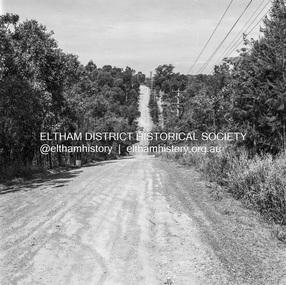
Photograph, Michael Wood, Progress Road looking east from near outside No. 196, Eltham North, 1976, 1976
... Progress Road looking east from near outside No. 196... melbourne Progress Road between Ryans Road and Lower Road, Eltham ...Progress Road between Ryans Road and Lower Road, Eltham North; prior to realignment and construction, 1976Kodak Safety Film 120 format 6 x 6 cm black and white negative; 1 strips, 2 frameseltham north, progress road, road construction -
 Eltham District Historical Society Inc
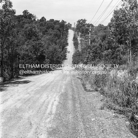
Photograph, Michael Wood, Progress Road looking east from near outside No. 196, Eltham North, 1976, 1976
... Progress Road looking east from near outside No. 196... melbourne Progress Road between Ryans Road and Lower Road, Eltham ...Progress Road between Ryans Road and Lower Road, Eltham North; prior to realignment and construction, 1976Kodak Safety Film 120 format 6 x 6 cm black and white negative; 1 strips, 2 frameseltham north, progress road, road construction -
 Eltham District Historical Society Inc
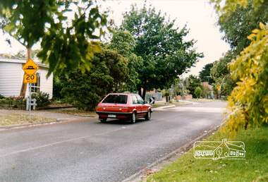
Photograph, Looking east near 51 Airlie Road, Montmorency, c.1989, 1989c
... Looking east near 51 Airlie Road, Montmorency, c.1989... east near 51 Airlie Road, Montmorency, c.1989 Photograph ...The Shire of Eltham was introducing a number of speed humps throughout the shire around this time period and took a photographic record of various new installations.Colour photographinfrastructure, airlie road, montmorency, speed humps, streets -
 Eltham District Historical Society Inc
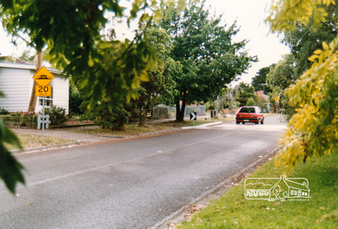
Photograph, Looking east near 51 Airlie Road, Montmorency, c.1989, 1989c
... Looking east near 51 Airlie Road, Montmorency, c.1989... east near 51 Airlie Road, Montmorency, c.1989 Photograph ...The Shire of Eltham was introducing a number of speed humps throughout the shire around this time period and took a photographic record of various new installations.Colour photographinfrastructure, airlie road, montmorency, speed humps, streets -
 Eltham District Historical Society Inc
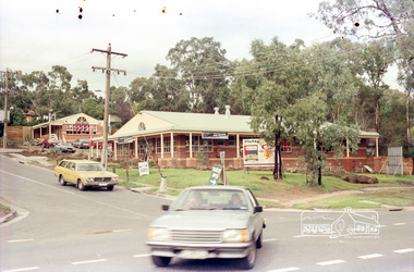
Photograph, View from the vicinity of Leanne Drive of the Food Plus Service Station at corner of Beard Street with Main Road, Eltham East, c.1987
... Service Station at corner of Beard Street with Main Road, Eltham... with Main Road, Eltham East, c.1987 Photograph ...Roll of 35mm colour negative film, 7 stripsKodak GA 100 5095roads, main road, beard street, bp service station, eltham east, food plus, leanne drive -
 Eltham District Historical Society Inc
Photograph, Corner of Beard Street with Main Road, Eltham East showing newly developed shops, c.1987
... Corner of Beard Street with Main Road, Eltham East showing... melbourne roads main road beard street eltham east shops nillumbik ...Roll of 35mm colour negative film, 7 stripsKodak GA 100 5095roads, main road, beard street, eltham east, shops, nillumbik bakery, bowz hair designers, real estate agent -
 Eltham District Historical Society Inc
Photograph, Looking south along the east side of Main Road towards York Street, Eltham, February 1968, Feb 1968
... Looking south along the east side of Main Road towards York... north along Main Road through the shopping centre to just north ...Shows Eltham Stock and Poultry Feed Store. Site of current Le Pine Funeral Home In February 1968 an unknown person took a series of photos from the Eltham Hotel at Pitt Street heading north along Main Road through the shopping centre to just north of Elsa Court covering the length of the section of Main Road which was duplicated shortly thereafter. Shows the condition and environment of the streesscape of Main Road, Eltham immediately prior to the duplication between Pitt Street and Elsa Court through the shopping centre. Also shows a number of shops and businesses that operated at that time.Black and white photographduplication, eltham, main road, briquettes, fuel merchant, le pine funeral home, york street, a.r warren, eltham feed store -
 Eltham District Historical Society Inc
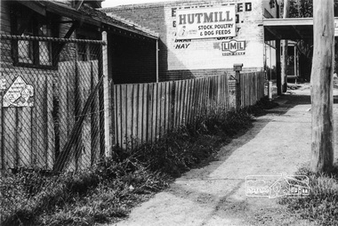
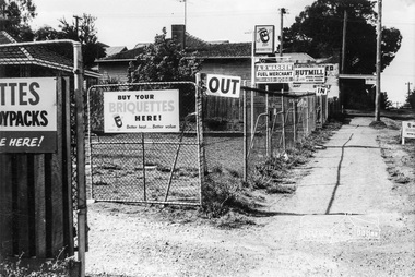
Photograph, Looking south along the east side of Main Road from Henry Street to Bridge Street, Eltham, February 1968, Feb 1968
... Looking south along the east side of Main Road from Henry... photograph Looking south along the east side of Main Road from Henry ...Shows Warrens Fuel Merchant yard and Eltham Feed Store. Site of current Le Pine Funeral Home In February 1968 an unknown person took a series of photos from the Eltham Hotel at Pitt Street heading north along Main Road through the shopping centre to just north of Elsa Court covering the length of the section of Main Road which was duplicated shortly thereafter. Shows the condition and environment of the streesscape of Main Road, Eltham immediately prior to the duplication between Pitt Street and Elsa Court through the shopping centre. Also shows a number of shops and businesses that operated at that time.Black and white photographduplication, eltham, main road, briquettes, fuel merchant, le pine funeral home, york street, a.r warren, eltham feed store -
 Eltham District Historical Society Inc
Photograph, Looking north from the east side of Main Road between Henry and York Streets, Eltham, February 1968, Feb 1968
... Looking north from the east side of Main Road between Henry... the east side of Main Road between Henry and York Streets, Eltham ...Eltham Shire Office and Shillinglaw trees to the left of photo In February 1968 an unknown person took a series of photos from the Eltham Hotel at Pitt Street heading north along Main Road through the shopping centre to just north of Elsa Court covering the length of the section of Main Road which was duplicated shortly thereafter. Shows the condition and environment of the streesscape of Main Road, Eltham immediately prior to the duplication between Pitt Street and Elsa Court through the shopping centre. Also shows a number of shops and businesses that operated at that time.Black and white photographduplication, eltham, main road, eltham shire offices, shillinglaw trees -
 Eltham District Historical Society Inc
Photograph, Our Lady's Church and school buildings on the east side of Main Road, Eltham, February 1968, Feb 1968
... Our Lady's Church and school buildings on the east side of... Hotel at Pitt Street heading north along Main Road through ...Shows car parking at left across Main RoadIn February 1968 an unknown person took a series of photos from the Eltham Hotel at Pitt Street heading north along Main Road through the shopping centre to just north of Elsa Court covering the length of the section of Main Road which was duplicated shortly thereafter. Shows the condition and environment of the streesscape of Main Road, Eltham immediately prior to the duplication between Pitt Street and Elsa Court through the shopping centre. Also shows a number of shops and businesses that operated at that time.Black and white photographduplication, eltham, main road, our ladys church -
 Eltham District Historical Society Inc
Photograph, Looking north along the east side of Main Road from near Henry Street, Eltham, February 1968, Feb 1968
... Looking north along the east side of Main Road from near... north along the east side of Main Road from near Henry Street ...Shows the Commercial Bank of Australia on the Dudley Street intersection and part of the War Memorial on the left amongst the parked cars.In February 1968 an unknown person took a series of photos from the Eltham Hotel at Pitt Street heading north along Main Road through the shopping centre to just north of Elsa Court covering the length of the section of Main Road which was duplicated shortly thereafter. Shows the condition and environment of the streesscape of Main Road, Eltham immediately prior to the duplication between Pitt Street and Elsa Court through the shopping centre. Also shows a number of shops and businesses that operated at that time.Black and white photographduplication, eltham, main road, commercial bank, eltham, dudley street, shire of eltham war memorial, arthur street, shopping centre, eltham shire office -
 Eltham District Historical Society Inc
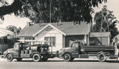
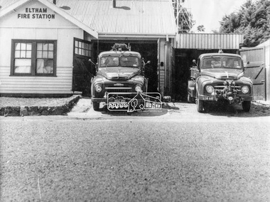
Photograph, Hugh Fisher, Eltham Fire Station, east side of Main Road, 1950s, 1950s
... Eltham Fire Station, east side of Main Road, 1950s... in 2002. eltham fire station Main Road Photo by Hugh Fischer, c ...The Eltham Fire Station was opened in 31 April 1935. Years later the building was removed and erected for use of 1st Research Scout Group in Research Park by the early 1970s to make way for the Eltham Village Complex which was under construction by 1971. The Research Scout Hall was destroyed by fire in 2002.Black and white photographPhoto by Hugh Fischer, c.1950seltham, fire station, main road -
 Eltham District Historical Society Inc
Photograph, George W. Bell, Eltham Fire Station, east side of Main Road, c.Jan 1964
... Eltham Fire Station, east side of Main Road... image Eltham Fire Station, east side of Main Road Photograph ...The photograph was taken (and donated) by George W. Bell during the period of fire, c.1963-c.1964. The actual fire station was built c.1930 and was in use till c.1964 when a new fire station was built on the opposite side of Main Road. The building, originally situated just south of Arthur Street, on Main Road was ultimately relocated in 1970 to Research Park for use by the 1st Research Scout group. The site is now part of the current Coles supermarket and Eltham Village complex. The Fire Trucks are an Austin STU (small town unit) on the left and an Austin urban pumper on the right. This photo forms part of a collection of photographs gathered by the Shire of Eltham for their centenary project book,"Pioneers and Painters: 100 years of the Shire of Eltham" by Alan Marshall (1971). The collection of over 500 images is held in partnership between Eltham District Historical Society and Yarra Plenty Regional Library (Eltham Library) and is now formally known as 'The Shire of Eltham Pioneers Photograph Collection.' It is significant in being the first community sourced collection representing the places and people of the Shire's first one hundred years.Digital imageaustin stu fire truck, austin urban pumper, eltham, eltham fire brigade, fire station, fire truck, george w. bell, motor vehicles, shire of eltham pioneers photograph collection -
 Eltham District Historical Society Inc
Photograph, Peter Pidgeon, Main Road looking east towards Fitzsimons Lane roundabout during Bolton Street upograde, 13 November 2017, 13/11/2017
... Main Road looking east towards Fitzsimons Lane roundabout... Road looking east towards Fitzsimons Lane roundabout during ...North bound lane closure. Born Digitalbolton street, bolton street upgrade, eltham, streets, main road, fitzsimons lane -
 Ringwood and District Historical Society
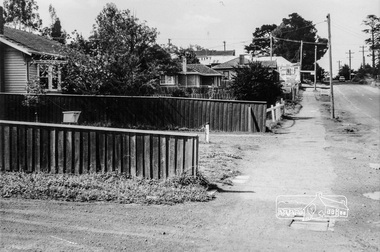
Photograph, Oban Road looking east from State School 1981
... Oban Road looking east from State School 1981...Written on back of photograph, "19/6/81. Oban Road looking..., "19/6/81. Oban Road looking east from State School". Oban Road ...Written on back of photograph, "19/6/81. Oban Road looking east from State School". -
 Ringwood and District Historical Society
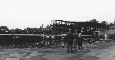
Photographs, Eastwood State School, Alexander Road, Ringwood East, severely damaged by fire - 2 May, 1970
... Eastwood State School, Alexander Road, Ringwood East..., Alexander Road, Ringwood East, severely damaged by fire - 2 May ...Printed below photograph, "Eastwood State School fire - 1970". Written on backing sheet, "See page 6 Ringwood Mail, 1/7/1970". -
 Ringwood and District Historical Society
Photograph, South east corner of Mines Road and Maroondah Highway, Ringwood. 1981
... South east corner of Mines Road and Maroondah Highway...Written on back of photograph, "24/7/81. South east corner..., "24/7/81. South east corner of Mines Road and Maroondah ...Written on back of photograph, "24/7/81. South east corner of Mines Road and Maroondah Highway." -
 Ringwood and District Historical Society
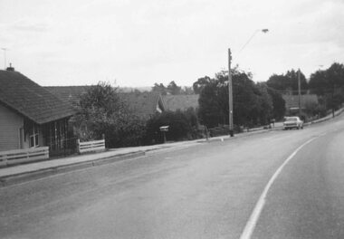
Photograph, Warrandyte Road from east corner of Oban Rd. intersection. North Ringwood 1981
... Warrandyte Road from east corner of Oban Rd. intersection...Written on back of photograph, "18/4/81. Warrandyte Road..., "18/4/81. Warrandyte Road from north-east corner of Oban Rd ...Written on back of photograph, "18/4/81. Warrandyte Road from north-east corner of Oban Rd. intersection". -
 Ringwood and District Historical Society
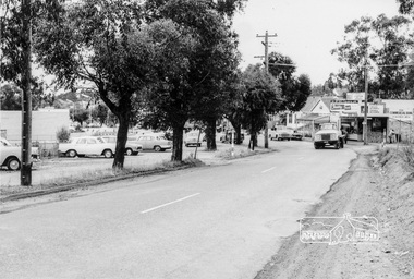
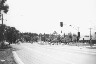
Photograph, Canterbury Road looking east from west side of Heatherdale Road intersection up towards Cadbury. Ringwood 1979
... Canterbury Road looking east from west side of Heatherdale... looking east from west side of Heatherdale Road intersection up..., "Jan. 79. Canterbury Road looking east from west side ...Written on back of photograph, "Jan. 79. Canterbury Road looking east from west side of Heatherdale Road intersection up towards Cadbury where road narrows down 3 to 1 lane. Before road widening." -
 Ringwood and District Historical Society
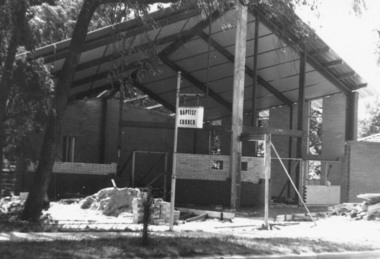
Photograph, Construction of East Ringwood Baptist Church in Dublin Road, Ringwood East prior to re-opening in 1966
... Construction of East Ringwood Baptist Church in Dublin Road..., "East Ringwood" East Ringwood Baptist Church in Dublin Road ...East Ringwood Baptist Church in Dublin Road being re-built prior to official opening on Saturday May 14, 1966.Written on back of photograph, "East Ringwood" -
 Ringwood and District Historical Society
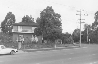
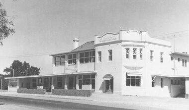
Photograph, Club Hotel, Mount Dandenong Road, Ringwood East - 1960
... Club Hotel, Mount Dandenong Road, Ringwood East - 1960.... Road Ringwood North melbourne Written on back of photographs ...Written on back of photographs, "Club Hotel Ringwood East. 1960." "Club Hotel, Mt. Dande Rd. 1960" and "1960 Club Hotel" -
 Ringwood and District Historical Society
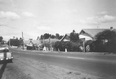
Photograph, Bedford Road,Ringwood East, looking west from outside No.128. (House far left is No.126) - 1/9/74
... Bedford Road,Ringwood East, looking west from outside No... is No.126 as in brochure. 1/9/74)" Bedford Road,Ringwood East ...Written on back of photograph, "Bedford Rd. looking west from outside No.128. (House far left is No.126 as in brochure. 1/9/74)" -
 Ringwood and District Historical Society
Photograph, South side of Bedford Road, Ringwood East, taken from outside shops on the corner of Illoura Avenue - 1/9/1974
... South side of Bedford Road, Ringwood East, taken from... Road Ringwood North melbourne Written on back of photograph ...Written on back of photograph, "Bedford Rd. looking at south side towards east from outside shops cnr. Illoura Ave. (As in brochure)" -
 Ringwood and District Historical Society
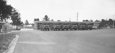
Photograph, Army Depot, Dublin Road, Ringwood East, 1973
... Army Depot, Dublin Road, Ringwood East, 1973...Written on backing sheet, "Army Depot, Dublin Road... Depot, Dublin Road, Ringwood East, 1973". Army Depot, Dublin ...Written on backing sheet, "Army Depot, Dublin Road, Ringwood East, 1973". -
 Ringwood and District Historical Society
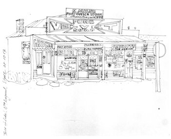
Photograph, Hand drawn picture by Eric Thake dated 1954 depicting Milne's Post Office and Store on the south-east corner of Oban Road and Warrandyte Road, North Ringwood
... Milne's Post Office and Store on the south-east corner of Oban... Road Ringwood North melbourne Typed below picture, "Mr. K ...Typed below picture, "Mr. K. Milnes store. Corner Oban Rd. and Warrandyte Rd. 1954. Now demolished". -
 Ringwood and District Historical Society
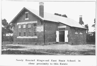
Photograph, Newly Erected Ringwood East State School, Everard Road, 1925 (Two Photographs)
... Newly Erected Ringwood East State School, Everard Road...". Newly Erected Ringwood East State School, Everard Road, 1925 ...Printed below photograph, "Newly Erected Ringwood East State School, in close proximity to this Estate". Written on back of photograph, "Photo taken from Sub. Div. plan Land Sale 1st November 1924. Ringwood East Electric Station Estate, 1st November 1924. School Everard Road". Typed below another copy: "Ringwood East S.S. On completion 1925". -
 Ringwood and District Historical Society
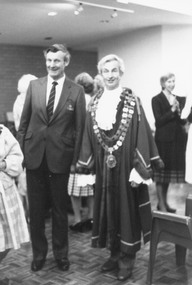
Photograph, City of Ringwood Chief Executive, Mr. Alan Robertson (left), and Mayor Cr. Bill Wilkins attending the opening of "Lionsbrae" aged care facility, Everard Road Ringwood East - 17/11/1985
... " aged care facility, Everard Road Ringwood East - 17/11/1985... of "Lionsbrae" aged care facility, Everard Road Ringwood East - 17/11 ...Black and white photograph Mr. Alan Robertson (left), Mayor Cr. Bill Wilkins. Partly obscured Cr. Betty Milton. -
 Ringwood and District Historical Society
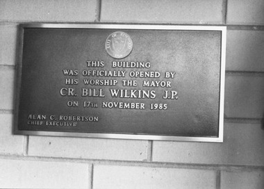
Photograph, Foundation stone at "Lionsbrae" aged care facility, Everard Road Ringwood East - 17/11/1985
... Road Ringwood East - 17/11/1985.... Road Ringwood North melbourne "This building was officially ...Catalogue card reads, 'Foundation stone at "Lionsbrae", 17/11/1985'."This building was officially opened by His Worship The Mayor Cr. Bill Wilkins J.P. on 17th November 1985 - Alan C. Robertson Chief Executive" -
 Ringwood and District Historical Society
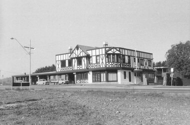
Photograph, Club Hotel, Mount Dandenong Road, Ringwood East 1973
... Club Hotel, Mount Dandenong Road, Ringwood East 1973... Road Ringwood North melbourne Black and white photographs ...Black and white photographs of Tudor style Club hotel