Showing 9591 items matching "east street"
-
 Port Melbourne Historical & Preservation Society
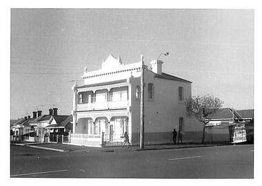
Photograph - Guernsey House, 232 Esplanade East, cnr. Bridge Street, Port Melbourne, Janet and Allen Walsh, 1973
... Guernsey House, 232 Esplanade East, cnr. Bridge Street... Melbourne Town Hall 333 Bay Street Port Melbourne melbourne Shot ...Shot in 1973 with particular interest in architectureSet of 31 photographs taken in June and July 1973 Guernsey House, Esplanade East, corner Bridge StIdentified and dated on back in inkbuilt environment - domestic, janet walsh, allen walsh, guernsey house, esplanade east -
 Ballaarat Mechanics' Institute (BMI Ballarat)
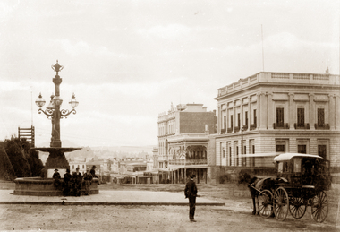
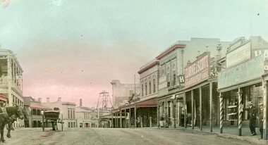
Looking east down Sturt Street
... Looking east down Sturt Street... St Looking east down Sturt Street ...This photograph is from the Max Harris Collection held by the Ballaraat Mechanics' Institute. Please contact BMI for all print and usage inquiries.ballarat, sturt, bridge st -
 Ballarat RSL Sub-Branch Inc.
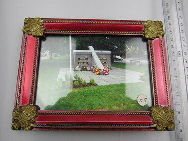
Photograph - Framed South East Memorial, Sturt Street, Ballarat
... Photograph - Framed South East Memorial, Sturt Street... South East Memorial, Sturt Street, Ballarat ...photo/pictures, ballarat rsl, ballarat -
 Ballarat Heritage Services
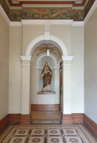
Photograph, Sacred Heart Mercy Convent, Victoria Street, Ballarat East
... Sacred Heart Mercy Convent, Victoria Street, Ballarat East... Mercy Convent, Victoria Street, Ballarat East, as well... Heart Mercy Convent, Victoria Street, Ballarat East, as well ...In 1872 members of the Jesuits purchased land in Walpole Street. Three years later, on 14 February 1875, Archbishop Gould laid a foundation stone for a school. By 1899 the land for the current church was purchased after mining speculator and Mt Lyell 'Copper King' James Crotty donated 3,000.00 pounds. The foundation stone was laid on 15 December 1918 by Archbishop Mannix. The cost of constructing the domed church was 15,000.00 pounds. A Fincham and Sons organ was installed in 1927, and refurbished in 1977. NEW PRESBYTERY AT KEW. Plans have been prepared by Mr. R. Harper, architect and builder, for the erection of a new presbytery for the Rev. P. Rafferty, adjoining the Sacred Heart Church, Cotham-road, Kew. The new building, which will be in brick and of two stories, will be behind the present priests' residence, which will continue to be used until the new presbytery is completed. The cost will be £6000, and the work will be begun almost immediately. The old presbytery was purchased many years ago by the late Rev. Fr. P. O'Donohue from the late Mr. Smart for £3000, and the full amount of the purchase money was donated by the late Mr. James Crotty. At different times additions were made to the building, but the small rooms made it altogether unsuitable as a residence for three priests, and made remodelling impracticable. The new presbytery will be in keeping with the Church of the Sacred Heart and the surroundings on the elevated site. At one time the old Sacred Heart Church was in Walpole-street, Kew. (The Advocate, 09 December 1937) The whole of the estate of the late Jas. Crotty has now been realised ex cepting 4000 shares in the Mount Lyell Company and a small parcel of general mining shares. All the debts and legacies, including £10,000 to St. Patrick's and £3300 to the testator's parish church at Kew, and also probate duty, have been paid. On present values the Mount Lyell shares. are worth a total of £37,000, and at the present rate of dividends the return represents an income of about £2000 per annum. Over and above this there is a sum of between £20,000 and £30,000 available for investment, and this, together with the dividends brings the income of the estate up to about £3000 per annum. A sum of £1100 per annum will be absorbed in annuities under the terms of the will. Whatever amount is realised beyond the sum necessary to pay the annuities goes to Archbishop Carr for the church and charitable purposes until the death of the last annuitant, when the resi duary estate will be divided between the Little Sisters of the Poor (North cote) and St. Joseph's Home (Surrey Hills). (Launceston Examiner, 18 July 1899) Sunday last being the anniversary of tire opening of the Sacred Heart Church, Kew, the pastor, Rev. Fr. Manly, made a special appeal at the various Masses. The beautiful design for marble altar for the Lady Chapel, which is on view in the vestibule, continues to attract attention. The Children of Mary Sodality have kindly undertaken to provide it, and the president, Miss Frances O'Sulliv!an, 43 Rideway-avenue, Kew, will be pleased to receive and acknowledge subscriptions from clients of Our Lady. They may also be placed in box near Lady Altar. (The Advocate, 06 December 1923) Number of photographes of the entrance to Sacred Heart Mercy Convent, Victoria Street, Ballarat East, as well as stained glass windows in the chapel.sacred heart mercy convent, ballarat east, stained glass window, sacred heart of jesus, john hove, announciation, kathleen blanche meagan, sacred heart college -
 Stawell Historical Society Inc
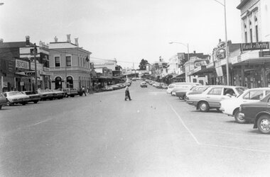
Photograph, Main Street Looking East with the Post Office on the left 1980's
... Main Street Looking East with the Post Office on the left...Main Street Looking East. Post Office 1980's... grampians Main Street Looking East. Post Office 1980's Stawell ...Main Street Looking East. Post Office 1980'sstawell streetscape -
 Stawell Historical Society Inc
Photograph, Main Street looking East from Newtons Butchers 1906
... Main Street looking East from Newtons Butchers 1906...Main Street looking East from Newtons Butchers 1906... grampians Main Street looking East from Newtons Butchers 1906 ...Main Street looking East from Newtons Butchers 1906stawell streetscape -
 Stawell Historical Society Inc
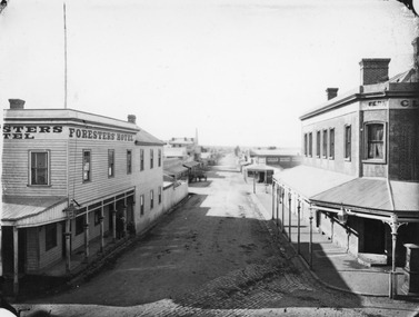
Photograph, Main Street & Patrick Streets corner looking East down Patrick Street with the Foresters Hotel on left corner 1878
... Main Street & Patrick Streets corner looking East down... looking East down Patrick Street. Weatherboard Foresters Hotel... looking East down Patrick Street. Weatherboard Foresters Hotel ...First floor view from corner of Main & Patrick Streets looking East down Patrick Street. Weatherboard Foresters Hotel in Main Street on left corner. Foresters Hotel was built in 1868 by Mr. Joseph Cawley, Mr. and Mrs. Cawley were the occupants for 30 years. The site was previously occupied by a Billiards Room. In 1917 the building became Foresters Coffee Palace with new owner Mr. J.C. Crothers who purchased the building for 410 pounds and leased it to Mr. Robert Wennerbom. The next lease holder was Miss Fulton and in 1921 Mrs. R. Claringbold took over and called the building Foresters House. The building was sold in 1935 and demolished shortly after sale. Businesses visible down Patrick street, Foresters Hotel, J.H. Wallis Royal Exchange Hotel on Big Hillside of Street. With St Patrick's church tower visible in distance. Melbourne Cash Store Wines and Spirits on corner of Patrick and Sloane Street near centre of photo. Ferns Hotel / Times office on right of photo, corner of Patrick and Main Street. Post Box on Corner at right of photo. 1878First floor view from Main Street Patrick Street intersection looking down Patrick Street. Foresters Hotel on left. Fern Boarding House on right.Victorian Views. C. Herbert, Photo. Stawell 1878stawell businesses streetscape -
 University of Melbourne, Burnley Campus Archives
Photograph - Black and white print, Aerial View of Burnley Campus, 1977
... east swan street... in the bend of the Yarra River, Glenferrie Road to the East Swan... river glenferrie road east swan street aerial view Framed ...Framed enlargements. (A) Burnley College and surrounding suburbs showing the nearly constructed Freeway, the College in the bend of the Yarra River, Glenferrie Road to the East Swan Street to the North. (B) Enlargement of (A) showing detail of Burnley College.burnley college, suburbs, freeway, yarra river, glenferrie road, east swan street, aerial view -
 Stawell Historical Society Inc
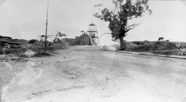
Photograph, Sloane's & Scotchman United Quartz Mining Co Looking East up upper Main Street c1916
... Sloane's & Scotchman United Quartz Mining Co Looking East...Sloane's & Scotchman Mining Co Looking East up upper Main... grampians Sloane's & Scotchman Mining Co Looking East up upper Main ...Sloane's & Scotchman Mining Co Looking East up upper Main Street The back view of the Ore Bin can be seen. Street view looking uphill towards mine site. Cows grazing at right.stawell mining -
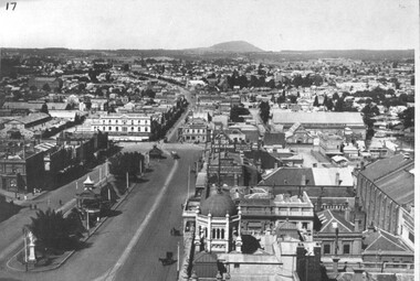 City of Ballarat Libraries
Photograph, Photo taken from the Town Hall Tower along Sturt Street facing east
... Photo taken from the Town Hall Tower along Sturt Street... Street looking east. The Camp Hill Gardens can be seen.... showing lower Sturt Street looking east. The Camp Hill Gardens can ...Photo taken from the Town Hall Tower showing lower Sturt Street looking east. The Camp Hill Gardens can be seen.town hall, ballarat, sturt street, ballarat east -
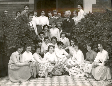 Federation University Historical Collection
Photograph - Photograph - Black and white, Ballarat Teachers' College Resident's at 130 Victoria Street, Ballarat East, 1960s, 1960s
... Street, Ballarat East, 1960s... Street, Ballarat East. Mavis Canty stand centre right in dark...130 Victoria Street, Ballarat East, Victoria , Australia... of their hostel at 130 Victoria Street, Ballarat East. Mavis Canty stand ...A number of female student teachers of the Ballarat Teachers' College pose at the front of their hostel at 130 Victoria Street, Ballarat East. Mavis Canty stand centre right in dark dress with a rose on the collar.Written on back "Ballarat Teachers' College, Mavis Canty with girls of the Ballarat Teachers College Hostel, 196-"ballarat teachers' college, 130 victoria street, hostel -
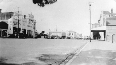 Stawell Historical Society Inc
Photograph, Main Street Stawell looking East from St Georges Street with McClure's Garage, Post Office & the State Savings Bank on right 1930
... Main Street Stawell looking East from St Georges Street... Savings Bank on Right. 1930 looking East from St Georges Street... Savings Bank on Right. 1930 looking East from St Georges Street ...Main Street Stawell McClure's garage Post Office State Savings Bank on Right. 1930 looking East from St Georges Streetstawell businesses streetscape -
 Ringwood and District Historical Society
Document - Book draft, History of St Stephens Uniting Church, Freeman Street, Ringwood East, Vic. May 1955 to October 2003, Feb-07
... History of St Stephens Uniting Church, Freeman Street..., Freeman Street, Ringwood East, Vic. May 1955 to October 2003... Stephens Uniting Church, Freeman Street, Ringwood East, Vic. May ...Handwritten draft - History of St Stephens Uniting Church, Freeman Street, Ringwood East, Vic. May 1955 to October 2003, compiled from minute books and church records by Keith Sutton, February 2007. -
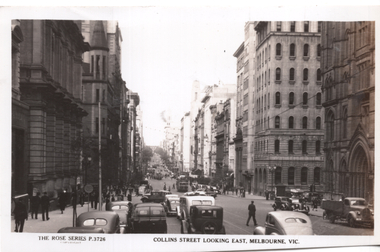 Melbourne Tram Museum
Postcard, Rose Stereograph Co, "Collins Street Looking East Melbourne", c1950
... "Collins Street Looking East Melbourne"...Rose Series postcard No. P 3726 titled "Collins Street... on the rear. Unused. "Collins Street Looking East Melbourne" Postcard ...Rose Series postcard No. P 3726 titled "Collins Street Looking East Melbourne" from near Market St. Has several W2 class trams in the distance. Yields information about Collins St from near Market St looking east.Postcard - printed real photograph with Rose Stereograph Co. name on the rear. Unused.trams, tramways, w2 class, collins st. -
City of Moorabbin Historical Society (Operating the Box Cottage Museum)
Document - Tenth Anniversary - Presbyterian Church East Bentleigh, 1957 - 1967, 1967
... Street East Bentleigh. The site and building is now (2022) being... Presbyterian Church East Bentleigh, built in 1957 in Cecil Street East ...Presbyterian Church East Bentleigh, built in 1957 in Cecil Street East Bentleigh. The site and building is now (2022) being used by Chabad, Bentleigh, which serves to cater to the needs of the Jewish Community.Presbyterian Church Bentleigh was formed to cater for the growing population of Bentleigh when the market gardens were subdivided into residential blocks.Document with blue cover, 18 pages. Contains text and pictures.parish of moorabbin, city of moorabbin, county of bourke, shire of moorabbin, market gardeners, presbyterian church east bentleigh, cecil street, east bentleigh, subdivision of land, religion -
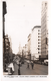 Melbourne Tram Museum
Postcard, Rose Stereograph Co, "Collins Street Looking East Melbourne", c1950
... "Collins Street Looking East Melbourne"...Rose Series postcard No. P 3495 titled "Collins Street... Stereograph Co. name on the rear. Unused. "Collins Street Looking East ...Rose Series postcard No. P 3495 titled "Collins Street Looking East Melbourne" from west of Elizabeth Steet Has a W2 class tram at the Elizabeth Street stop. On the right is the newly completed Royal Bank chamber, completed in 1941, and the MLC buliding. Yields information about Collins St from near Queen St looking east. 1940'sPostcard - printed real photograph with Rose Stereograph Co. name on the rear. Unused.trams, tramways, w2 class, collins st, elizabeth st -
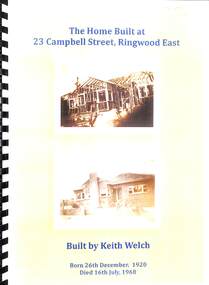 Ringwood and District Historical Society
Book, Biography of owner of 23, Campbell Street, Ringwood East, 1920-1968
... Biography of owner of 23, Campbell Street, Ringwood East... built and lived in the house at 23, Campbell Street, Ringwood... and lived in the house at 23, Campbell Street, Ringwood East ...Keith Welch was a local builderBiography in yellow covered spiral binder containing a short biography of Keith Welch (26-12-1920 - 16-7-1968) who built and lived in the house at 23, Campbell Street, Ringwood East. Complied by his widow Gloria Welch in 2008. Contains many family photos and associated family events. The house was sold by Richard Carter in 2013. -
 Stawell Historical Society Inc
Photograph, Upper Main Street Looking East 1886
... Upper Main Street Looking East 1886...Upper Main Street Looking East 1886. From left J... grampians Upper Main Street Looking East 1886. From left J ...Upper Main Street Looking East 1886. From left J Allingham Drapers. J Chadwick & Co Drapers. Bank of Victoria partly obscured, Commercial Hotel, Oriental bank, Punchard's Furniture. On right is the side of Mechanics Institute obscured. B.S. Dawson Chemists & Wadsworth Watchmaker. English Scottish & Australian Bank . Upper Main Street scene with people standing in roadway, Side of cart visible on left. c 1880stawell streetscape -
 Ringwood and District Historical Society
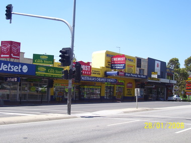
Photograph, Former shops to the east of Melbourne Street in January 2008. Knocked down in later preparation for construction work beginning at the Ringwood Railway Station and Stage 5 of Eastland circa 2014
... Former shops to the east of Melbourne Street in January... in 2008-2014, member of RDHS Former shops to the east of Melbourne ...Photographs taken by Terry Ahern in 2008-2014, member of RDHS -
 Ringwood and District Historical Society
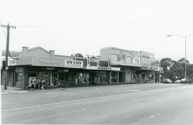
Photograph, North side of Maroondah Highway, Ringwood Shops east of Melbourne Street on 26th January, 1991
... North side of Maroondah Highway, Ringwood Shops east of... of Maroondah Highway, Ringwood Shops east of Melbourne Street on 26th ...Digital photograph -
 Eltham District Historical Society Inc
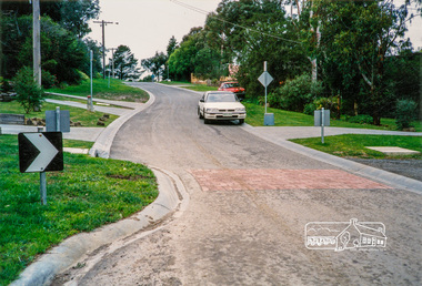
Photograph, Looking east along Pitt Street towards the intersection with Bible Street, Eltham, c. September 1966, 1966c
... Looking east along Pitt Street towards the intersection... photographic print Looking east along Pitt Street towards ...Black and white photographic printOriginally located in a Filmpro King Size Prints processing envelope $3.01 Shire of Eltham 9/9/66 and noted as Calrossie Ave area and crossed out Eltham-Yarra Glen Road, Bridge Street to Elsa Court existing conditions mid 1967bible street, eltham milk bar, pitt street, road construction, streets -
 Eltham District Historical Society Inc
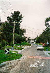
Photograph, Looking east along Pitt Street, Eltham, c. September 1966, Stebbing Cottage on right, 1966c
... Looking east along Pitt Street, Eltham, c. September 1966... photographic print Looking east along Pitt Street, Eltham, c. September ...Stebbing cottage on rightBlack and white photographic printOriginally located in a Filmpro King Size Prints processing envelope $3.01 Shire of Eltham 9/9/66 and noted as Calrossie Ave area and crossed out Eltham-Yarra Glen Road, Bridge Street to Elsa Court existing conditions mid 1967pitt street, road construction, stebbing cottage, streets -
 Eltham District Historical Society Inc
Slide, Quinn Estate looking east along Sackville Street just prior to Quinn Way, Montmorency, c.Oct. 1980
... Quinn Estate looking east along Sackville Street just prior... Sackville Street Processed Oct 1980 35 mm colour positive ...One of a series of images of roads and infrastructure focussed on the Quinn Estate in Montmorency taken by Eltham Shire Council Planning and Engineering officers. They provide perspective of the changes in housing styles and road development that began sweeping in from the mid 1970s with increasing urbanisation of what was once more outlying suburbs and regions.35 mm colour positive transparency Mount - Kodak Kodachrome CardProcessed Oct 1980roads, housing estate, infrastructure, montmorency, quinn estate, quinn way, sackville street -
 Eltham District Historical Society Inc
Slide, Looking east up Baxter Street from Bolton Street, Eltham, 18 July 1972, 1972
... Looking east up Baxter Street from Bolton Street, Eltham... Mount - Agfacolor Service (Blue) Looking east up Baxter Street ...Reconstruction works by Eltham Shire Council, Bolton Street, Eltham, 18 July 1972 35 mm colour positive transparency Mount - Agfacolor Service (Blue)baxter street, bolton steet, bolton street shops, eltham, eltham shire council, infrastructure, main road, road construction -
 Eltham District Historical Society Inc
Slide, Looking east up Thornton Street from Bolton Street, Eltham, 18 July 1972, 1972
... Looking east up Thornton Street from Bolton Street, Eltham...) Looking east up Thornton Street from Bolton Street, Eltham, 18 ...Reconstruction works by Eltham Shire Council, Bolton Street, Eltham, 18 July 197235 mm colour positive transparency Mount - Agfacolor Service (Blue)bolton steet, eltham, eltham shire council, infrastructure, road construction, thornton street -
 Eltham District Historical Society Inc
Slide, Looking east along Godalmin Street from Bolton Street, Eltham, 18 July 1972, 1972
... Looking east along Godalmin Street from Bolton Street... Street, Eltham, 18 July 1972 House on right is No. 4 Godalmin ...Reconstruction works by Eltham Shire Council, Bolton Street, Eltham, 18 July 1972 House on right is No. 4 Godalmin Street Godalmin Street is now not connected to Bolton Street35 mm colour positive transparency Mount - Agfacolor Service (Blue)bolton steet, eltham, eltham shire council, godalmin street, infrastructure, road construction -
 Eltham District Historical Society Inc
Photograph, Looking east along Walsh Street towards Porter Street, Eltham, just past the Bolton Street shops, c.1989, 1989c
... Looking east along Walsh Street towards Porter Street... Street Colour photograph Looking east along Walsh Street towards ...Colour photographeltham, streets, bolton street shops, porter street, walsh street -
 Eltham District Historical Society Inc
Photograph, Looking east along Walsh Street towards Porter Street, Eltham, just past the Bolton Street shops, c.1989, 1989c
... Looking east along Walsh Street towards Porter Street... street Colour photograph Looking east along Walsh Street towards ...Colour photographeltham, streets, bolton street shops, porter street, walsh street -
 Eltham District Historical Society Inc
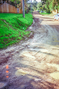
Photograph, Road surface conditions around Eltham: Looking east along Franklin Street from intersection with Bible Street, 7 Aug 1996, 1996
... Road surface conditions around Eltham: Looking east along... conditions around Eltham: Looking east along Franklin Street from ...Shows sections of Franklin, John and Napoleon streets were still unmade as of late 1996 and the condition of those roads with potholes at the intersections with Bible Street.Reflects on the changing nature of the local street-scape and housesRoll of 35mm colour negative film, 7 stripsKodak Gold 100-5eltham, napoleon street, bible street, franklin street, john street -
 Eltham District Historical Society Inc
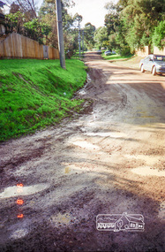
Photograph, Road surface conditions around Eltham: Looking east along Franklin Street from intersection with Bible Street, 7 Aug 1996, 1996
... Road surface conditions around Eltham: Looking east along... conditions around Eltham: Looking east along Franklin Street from ...Shows sections of Franklin, John and Napoleon streets were still unmade as of late 1996 and the condition of those roads with potholes at the intersections with Bible Street.Reflects on the changing nature of the local street-scape and housesRoll of 35mm colour negative film, 7 stripsKodak Gold 100-5eltham, napoleon street, bible street, franklin street, john street