Showing 6959 items matching "entrances"
-
 Phillip Island and District Historical Society Inc.
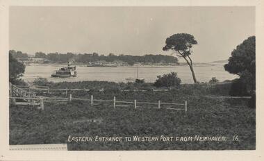
Photograph - Post Card, Early 20th Century
One of a group of photographs from the Bryant West Collection donated by Mary Karney.Black & White postcard of the Eastern Entrance to Westernport showing a Ferry and other vessels with San Remo on the other side of the bay.Eastern Entrance to Western Port from Newhaven. 16.western port phillip island, ferries, san remo, bryant west collection, mary karney -
 Lakes Entrance Historical Society
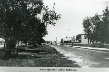
Photograph - Lakes Entrance, 1920c
Also 10 x 15 cm sepia copy, has remnants of glue of the back, little bit fadedBlack and white photograph of Esplanade, showing Maranui Guest House, Police Station, corner of Bellevue Guest House and Club Hotel in distance. Natural vegetation of Coastal Banksia on grass verge between road and waterfront, and beside Maranui Guest House. Lakes Entrance VictoriaThe Esplanade Lakes Entrancewaterfront, township, guesthouses, police -
 Lakes Entrance Historical Society
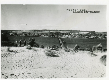
Postcard - Township, 1950c
2 copies 6 x 9Black and white small format postcard of footbridge over Cunninghame Arm. It shows people on bare sand dunes in foreground boat moored beside bridge, motor vehicles parked along retaining wall on North shore with town buildings in background. Lakes Entrance VictoriaFootbridge Lakes Entrancebridges, waterways, township, people -
 Lakes Entrance Historical Society
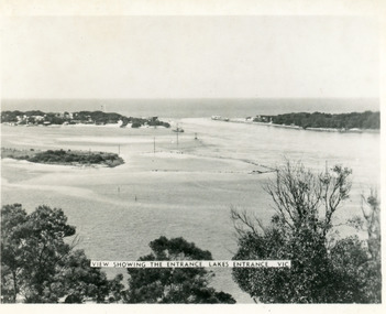
Photograph - The Entrance, Martin Orville, 1940c
Another copy Black and white 7 x 8.5 with inscription'View showing the Entrance, Lakes Entrance, Vic'Black and white photograph of Bullock Island, the New Works, township and entrance from Bass Strait to the Gippsland Lakes. Taken at high tide. Lakes Entrance Victoriaislands, waterways, topography -
 Glenelg Shire Council Cultural Collection
Photograph - Photograph - Casterton, Victoria, c. 1963
SOURCED FROM CASTERTON TOWN HALL (FORMER SHIRE OF GLENELG)Black and white photo. View of entrance to the Administration block of the Casterton HospitalBack: 'Casterton Memorial Hospital Entrance to Administration Block' - handwritten in green birocasterton, casterton hospital -
 Lakes Entrance Historical Society
Postcard - Backwater, Bulmer H D, 1922c
Black and white photographic postcard, showing early aerial view of township of Lakes Entrance, Cunninghame Arm, North Arm and sand dunes, ocean in lower foreground, Eastern wharf and various boats on lake. Princes Highway went along Esplanade, Myer Street and Roadknight Street, very little vegetation on sand dunes, no foot bridge yet, good view of North Arm, few houses. Lakes Entrance VictoriaLakes Entrance and Backwater from the Air.islands, aerial photograph, waterways, topography, township -
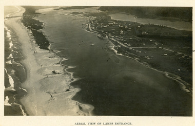 Lakes Entrance Historical Society
Photograph - Lakes Entrance, 1923c
Two copies 16.5 x 25.5 very darkBlack and white photograph showing early aerial view of township of Lakes Entrance, photo shows highway going along Myer Street and along Roadknight Street, no shops in Myer Street appears to be no foot bridge, therefore taken prior to 1937, sparce vegetation on foreground dunes, four barriers built on dunes to stop erosion through sand, two masted sailing boat in lake. Bullock Island in distance appears very small, Snake Island of Rigby Island in centre distance. Lakes Entrance VictoriaAerial View of Lakes Entrancewaterways, coast, aerial photograph, islands, township -
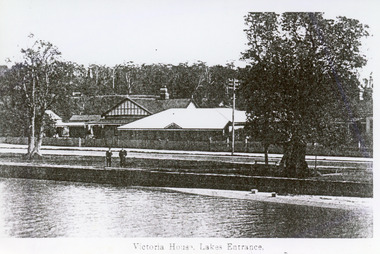 Lakes Entrance Historical Society
Photograph - Victoria House, 1920c
Photo taken prior to 1924, no memorial cypress treesBlack and white tinted photograph of Victoria House, showing a group of buildings on Esplanade. Rock wall on edge of lake. Two coastal banksias on verge of road, two men standing on rock wall. Lakes Entrance VictoriaVictoria House Lakes Entranceguesthouses, waterfront, architecture -
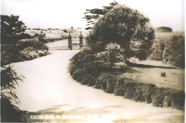 Port Fairy Historical Society Museum and Archives
Photograph, Entrance to Gardens, Port Fairy
Entrance to gardens Port Fairy. The Port Fairy Botanical Gardens were formed in 1856 making it one of the earliest gardens in Victoria. The first curator was James Prior, he was paid fifty-two pounds per annum. He was an outstanding curator having been apprenticed to the trade in England at the age of 12, his brother Edward in later years was the Curator of the Koroit Gardens. Prior retired in 1903. During the years of his curatorship Port Fairy was said to have the best gardens outside the city of Melbourne, he was constantly in touch with Baron Von Mueller and later Guilfoyle of the Royal Botanical Gardens of Melbourne. In the early years plants from all over the world were planted here with varying rates of success many of them sent by Baron Von Mueller. In the 1930’ and 40’s the gardens were still very beautiful, and the curator was Roy Manuell. The beautiful iron gates at the entrance were destroyed in the 1946 floods and were replaced in 1989 using some of the material from the original gates. From the 1950’s on the gardens went into a state of decline, much being taken up by the caravan park until in 1986, after a public meeting ‘Friends of the Gardens’ was founded when the entrance section was restored. PhotographEntrance to Gardens Port Fairybotanical gardens, gate, path, dunes -
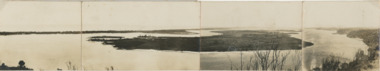 Lakes Entrance Historical Society
Postcard, Reeves Channel, Rigby Island, the entrance, Bullock Island , Lakes Entrance Victoria, 1920 c
Views of Gippsland Lakes from Jemmy's Point Lakes EntranceBlack and white panoramic folding postcard of the Gippsland Lakes including Reeves Channel, Rigby Island, the entrance, Bullock Island and Lakes Entrance township taken from Jemmys Point Lakes Entrance Victoria. Also panoramic postcard view from southern part of Rigby Island to Lakes Entrance township. And a third postcard "KALIMNA COVE LAKES ENTRANCE"waterways, gippsland lakes -
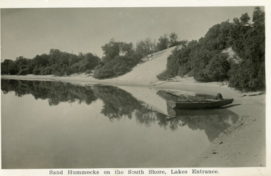 Lakes Entrance Historical Society
Postcard, Bulmer H D, Cunninghame Arm. Lakes Entrance Victoria, 1930c
Black and white postcard of the south shore of Cunninghame Arm. It shows a rowing boat with dog, on the shore and the scrub covered sand hummocks. Lakes Entrance VictoriaSand Hummocks on South shore, Lakes Entrance.bridges, topography, waterways -
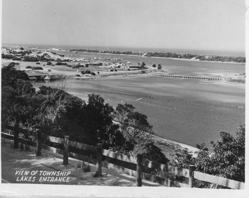 Lakes Entrance Historical Society
Postcard - North Arm bridge Lakes Entrance Victoria, 1947c
Black and white small format postcard showing town, North Arm bridge, post and rail fence beside the road, bridge to Bullock Island, Cunninghame Arm and sand hummocks, motor boat on the lake. Lakes Entrance VictoriaView of Township Lakes Entrancebridges, township -
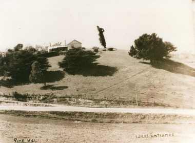 Lakes Entrance Historical Society
Photograph - Pine Hill Guesthouse, 1950c
Also second copy which is a very clear photo.Sepia toned photograph of Pine Hill Guesthouse, showing rambling building on top of hill, landmark tree, and pine trees on hillside. Road in foreground is Princes Highway. In far distance a glimpse of Cunninghame Arm. Lakes Entrance VictoriaPine Hill Lakes Entranceguesthouses, roads and streets, topography -
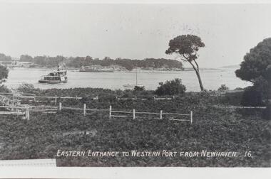 Phillip Island and District Historical Society Inc.
Photograph, Early 20th Century
One of 20 photographs/postcards donated by Mary KarneyBlack & White copy of a postcard showing the eastern entrance to Westernport from Newhaven. A ferry and yacht in the foreground and a vessel on the other side."Eastern Entrance to Western Port from Newhaven. 16."westernport bay, newhaven phillip island, eastern entrance to westernport, mary karney -
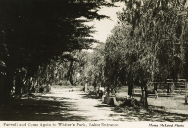 Lakes Entrance Historical Society
Postcard - Whiters Camp Park, Mona McLeod, 1935
Black and white postcard of back entry or exit through tree lined driveway of Whiters Camp Park Lakes Entrance VictoriaFarewell and Come Again to Whiters Park Lakes Entrancecamping, businesses, roadways -
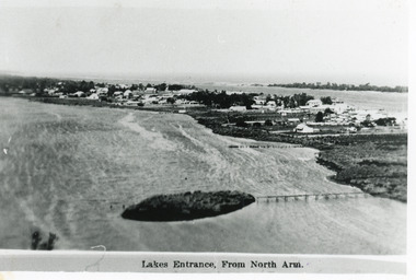 Lakes Entrance Historical Society
Photograph - Lakes Entrance, 1915c
Other copy 12.5 x 17.5Black and white photograph of the North Arm, showing a mud island in the arm behind the township, Cunninghame Arm, sand hummocks of the southern shore and Bass Strait in distance. Lakes Entrance VictoriaLakes Entrance from North Armtownship, waterways -
Lakes Entrance Historical Society
Book, Goff John, Hunt Cecil, The Story of Two Mustard Seeds, 1986
Discribes the church and the area it stands in Lakes Entrance VictoriaPresented to the Tambo shire Historical society with the compliments of the Lakes Entrance Uniting Church April 1986religion, township -
 Lakes Entrance Historical Society
Photograph - Lakes Entrance, 1945c
Two tinted copies, one 8.5 x 13.5 and one 6.5 x 9Black and white postcard showing town, twelve memorial cypress trees and spotting tower on foreshore, post office wharf, boat harbour, Club Hotel at west end of esplanade with five palm trees opposite, causeway to Bullock Island, highway bridge over North Arm, highway up to Jemmys Point, Rigby, Fraser and Flannagan Island's towards Metung. Lakes Entrance VictoriaLakes Entrance islands, aerial photograph, waterways, township -
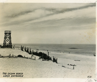 Lakes Entrance Historical Society
Postcard - Ocean Beach, 1950c
Black and white small format postcard of the ocean beach. It shows an expanse of sand dune, remains of a brush windbreak fence, and the observation tower, built for Royal Lifesaving Club, pre Surf Life Saving Club. Lakes Entrance VictoriaThe Ocean Beach Lakes Entrancebeaches, surf lifesaving -
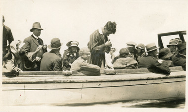 Lakes Entrance Historical Society
Photograph, 1925
Date made January 1925Black and white photograph showing crowd of tourists aboard ferry on lakes, at Lakes Entrance, Victoria.Alf and Jeans Honeymoon, Photo at Lakes Entrance, Jan 1925 (on back)waterways, boats and boating, tourism, celebration -
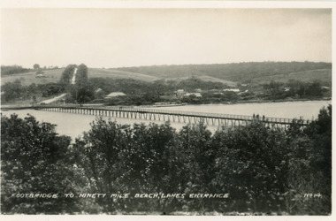 Lakes Entrance Historical Society
Postcard - Footbridge, No14 Bulmer HD, 1940c
1 same image 6.5x10.5 valentine Series donated by Keith West|1 other similar image 6.5 x 10.5|1 other similar image 9 x 14|1 other similar postcard, message on back in Spares BoxBlack and white small format postcard of the footbridge across the Cunninghame Arm, which is the access to the southern shore and ocean beach from the town. Lakes Entrance VictoriaFootbridge to Ninety Mile Beach, Lakes Entrance bridges, waterways, township -
Canterbury History Group
Photograph - Hislop Entrance, Canterbury Gardens, Jan Pigot, 1998
... Entrances ...Hislop Entrance to Canterbury Gardens, erected to commerate Councillor and Mrs Hislop and their services to the City of Camberwellcanterbury, canterbury gardens, canterbury road, entrances, mayors, councillors, hislop family -
 Marysville & District Historical Society
Photograph (Item) - Colour photograph, 20-09-2008
A colour photograph of the entrance to The Big Culvert.A colour photograph of the entrance to The Big Culvert. The Big Culvert is a historic granite and bluestone arch along the Yarra Track, a major route to Melbourne through the 1800s. Built in 1870 and a major piece of infrastructure for its time, the heritage listed culvert allowed water to flow under often-flooded the road. The Yarra Track is the former name of the gold fields road from Healesville to the Woods Point and Jordan Goldfields, in Victoria, Australia. A direct route via the Yarra River and the Great Divide was discovered by Rieck in September 1862 and became known as the Yarra Track. Early in 1863, the Victorian Government decided to construct a 193-kilometre (120 mile) road along the route. Its original width varied between 4 and 6 metres (12 and 20 feet), and was designed to accommodate horse-drawn vehicles. The Track involved the climbing of the Black Spur, descent into the Acheron Valley, and then through Marysville to the Cumberland where it followed the existing route.the big culvert, yarra track, victoria, healesville, wood's point goldfields, jordan goldfields, black spur, acheron valley, cumberland valley -
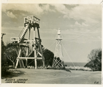 Lakes Entrance Historical Society
Postcard - Lookout tower Jemmy's Point, Valentine Series, 1940
Black and white small format postcard of the timber observation lookout at Jemmys Point, Lakes Entrance, Victoria, showing the timber tower with observation deck, signal light on steel tower nearby. Top of old standing lookout tree just visible.Jemmys Lookout Lakes Entrancehistoric sites, navigation -
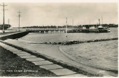 Lakes Entrance Historical Society
Postcard - Post Office Jetty, 1940c
Black and white small format postcard of the Post Office Jetty, showing a steamer at the end of the jetty, the passenger shelter, rock groyne from shore into lake, bluestone rock retaining wall and flagstone path at edge of lake, three electricity poles and one memorial cypress tree in distance. Lakes Entrance VictoriaThe Pier Lakes Entrancememorials, waterfront, ships and shipping -
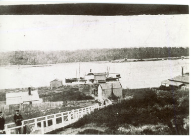 Lakes Entrance Historical Society
Photograph - New Works, 1910c
Also two other black and white copies 9 x 13 cmSepia photograph showing buildings on dunes at New Works. Building on left is works office, centre is school, right is harbour master's home. Steamer at wharf, boardwalk with two men. Lakes Entrance VictoriaLakes Entrance (New Works Jetty)boardwalk, waterways, historic site -
 Lakes Entrance Historical Society
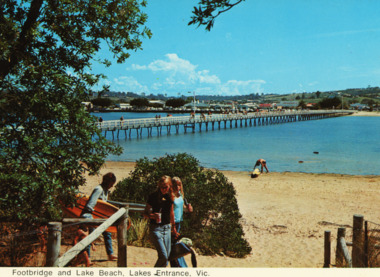
Postcard - Footbridge Cunninghame Arm, 1970 c
Colour postcards showing views of footbridge, part of Cunninghame Arm, east end of township and Myer Street hill in background and approach to ocean beach Lakes Entrance VictoriaFootbridge and lake beach Lakes Entrance Vicbridges -
 Lakes Entrance Historical Society
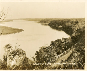
Postcard - Reeves Channel, Valentine Series, 1930c
Black and white small format postcard of Reeves Channel Gippsland Lakes, taken from Jemmys Point. It shows a glimpse of the Princes Highway, the steep shoreline of the mainland opposite Rigby Island with Fraser Island and Flannagan Island in distance. Lakes Entrance VictoriaKalimna Cove Lakes Entranceislands, waterways, topography -
 Lakes Entrance Historical Society
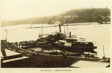
Photograph - New Works Jetty, 1910 c
Black and white photograph showing two steamers at New Works wharf, five or six other smaller vessels and crowds of people on wharf and steamers. Small shed on end of wharf, rooves of two buildings in foreground. Jemmys Point hill in the background and timber barrier wall for formation of Bullock Island. Lakes Entrance Victoria.The Wharf, Lakes Entranceships and shipping, waterways, jetties, people -
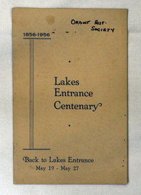 Orbost & District Historical Society
booklet, James Yeates & Sons, Lakes Entrance Centenary, 1956
This book contains a detailed history of Lakes Entrance in east Gippsland and was produced by the committee for the Back to Lakes Entrance celebration in May 1956.This booklet is a useful reference tool on the history of lakes Entrance.20 pp booklet titled "Lakes Entrance centenary 1856-1956 Back to Lakes Entrance May 19-May 27". It has a beige coloured cover with black print.on cover - top right - " Orbost hist. Society" hand-printed in black. lakes-entrance-history