Showing 460 items
matching freeways
-
 Melbourne Tram Museum
Slide, Keith Kings, 10/08/1968 12:00:00 AM
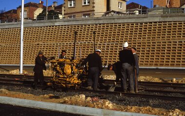
35mm Kodak white cardboard colour slide by Keith Kings of 10/8/1968 Queensway, St Kilda Junction road works, track tamping using a VR hired tamper. Note the cloth wrapped up caps on two of the workers - Italian immigrants most likely. See Keith's slide notes.Keith Kings stamp and number "32-27", with details of exposure. "VR tampers on hire in Freeway section of new track near Punt Road 10/8/68".trams, tramways, st kilda junction, trackwork, road works, queensway, ballast -
 Kew Historical Society Inc
Plan - 30 Choice Home Sites in Kilby Road, Meldrum Street and Fairway Drive, 1965
Subdivision plans and real estate flyers/brochures reveal a number of aspects of urban development and history. The Kew Historical Society's collection of these plans, as well as advertisements extracted from magazines, cover key aspects of community development and architectural history of Kew and Kew Eat as well as surrounding suburbs. While most of the plans in the collection were gifted to the Society by the former City of Kew, a number of other plans and advertisements have been donated by individuals, of which this is an example.Original 4-page, bifold brochure, one of two in the collection, of home sites created following the creation of the Eastern Freeway which separated a section of land owned by the Kew Golf Club from the main course. The new estate featured 30 lots in Meldrum Street, Kilby Road and Fairway Drive. subdivisions -- kew east (vic.), subdivisions -- kew (vic.), kew golf club -
Kew Historical Society Inc
Plan - 30 Choice Home Sites in Kilby Road, Meldrum Street and Fairway Drive, 1965
Subdivision plans and real estate flyers/brochures reveal a number of aspects of urban development and history. The Kew Historical Society's collection of these plans, as well as advertisements extracted from magazines, cover key aspects of community development and architectural history of Kew and Kew Eat as well as surrounding suburbs. While most of the plans in the collection were gifted to the Society by the former City of Kew, a number of other plans and advertisements have been donated by individuals, of which this is an example.Original 4-page, bifold brochure, one of two in the collection, of home sites created following the creation of the Eastern Freeway which separated a section of land owned by the Kew Golf Club from the main course. The new estate featured 30 lots in Meldrum Street, Kilby Road and Fairway Drive.subdivisions -- kew east (vic.), subdivisions -- kew (vic.), kew golf club -
Whitehorse Historical Society Inc.
Document, Eastern Corridor Study, 9/10/1975
... Freeways ...Bulletin, Eastern Corridor Study (Combining Koonung and Ringwood Studies) issued by the study consultants, Alan M. Voorhees & Partners P/L, Bulletin No 3, 9 October 1975: Routes 'A', 'B' and 'E' - Ringwood Sector, Lines of minimum impact.eastern freeway, alan m. voorhees & partners p/l, roads and streets, freeways, ringwood, mitcham -
Greensborough Historical Society
Newsletter, Greenhills and North Greensborough Progress Association, Community News: official journal of the Greenhills and Nth. Greensborough Progress Association and the Apollo Parkways Progress Association. December 1979, 12/1979
G.A.G.P.A. alive and well, The F5/F18 freeway and Diamond Valley Council, Diamond Creek road... what next??, Chain-sore reaction!!, Kinder news, Diamond Valley Repertory.Newsletter, 4 p.greenhills and north greensborough progress association, greenhills, apollo parkways progress association, apollo parkways -
 Melbourne Tram Museum
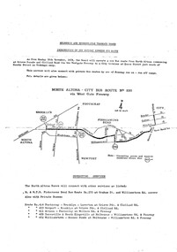
Document - Timetable/s, Notice, Melbourne & Metropolitan Tramways Board (MMTB), "Introduction of new Weekday Express Bus Service - North Altona - City Bus Route No. 232", Nov. 1978
Photocopy onto a foolscap double sided, of the introduction of a new bus service along the West Gate Freeway - 20/11/1978 - titled "Introduction of new Weekday Express Bus Service - North Altona - City Bus Route No. 232". Shows a map of the service, details of connecting services, stopping places, fares and timetable.trams, tramways, buses, timetables, north altona, route 232 -
 Greensborough Historical Society
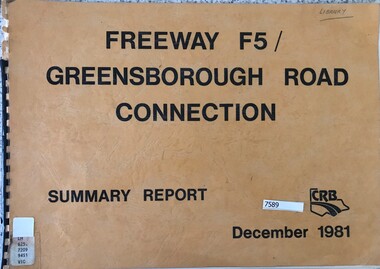
Book - Report, Country Roads Board, Freeway F5 / Greensborough Road connection. December 1981, Summary Report, 1981_
Summary report of the Country Roads Board's 1981 proposals for the F5 Freeway (now Metropolitan Ring Road) between Dalton Road and Diamond Creek Road and the duplication of Greensborough Road (Greensborough By-pass).Historic proposal for roads in the Greensborough area51 pages, text, colour maps. Plastic binding.country roads board, greensborough bypass, metropolitan ring road, greensborough road -
 Greensborough Historical Society
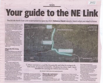
Article - Newspaper Clipping, Your guide to the NE Link
The North East link Project, is touted as the biggest road project in Victoria's history and will connect the Metropolitan Ring Road to the Eastern Freeway at Bulleen Road. This Feb 2020 article outlines the reasons for the project.News clipping, black and white text and colour image.north east link, , rosanna road rosanna, metropolitan ring road -
Robin Boyd Foundation
Letter, Melbourne and Metropolitan Board of Works, 31.03.1958
Letter to Robin Boyd regarding his letter about the proposed Eastern Suburbs Freeway to cross Riversdale Rd and Woodlands Avenue (right beside 158 Riversdale Rd, the Boyd family home). -
 Melbourne Tram Museum
Document - Report, Australian Electric Traction Association (AETA), Set of 6 options for Doncaster Light Rail Line, 1991
In 1991, the Australian Electric Traction Association (AETA) produced 7 different options to provide public transport to the Doncaster area. See reference for background to the proposals. Six of the seven options have been found and collected. Each option provides a summary, costing based in a scope of works. The Options were: 1 - Light Rail to Doncaster Shoppingtown via Eastern Freeway/Doncaster Road 2 - Light rail to Mitcham Road/Springvale Road 3 - High-performance train to Doncaster Shoppingtown via Victoria Park station Eastern Freeway/Doncaster Road 4 - Heavy rail to Doncaster Shoppingtown via Eastern Freeway to Bulleen Road and underground to Shoppingtown 5 - Heavy Rail to Blackburn Road/George St East Doncaster 7 - Extension of the Camberwell Tram (72) along Burke Road from Cotham Road to Doncaster Road. Out of all the studies, nothing happened.Yields information about the early 1990s proposal to provide public transport to the Doncaster area.Set of 6 reports or options printed on A4 paper, stapled in top left hand corner.tramcars, tramways, aeta, new tramways, doncaster, railways, light rail -
Whitehorse Historical Society Inc.
Document, Eastern Freeway Extension, 2000 - 2002
Eastern Freeway ExtensionEastern Freeway Extension- Cost estimates for community consultation option Public consultation process : report on analysis submissions Deep Creek Road - Landscape concept Media Release from Premier of Victoria VicRoads - Works update newsletters Whitehorse City Council minutes VicRoads Correspondence Schwerkolt Cottage Precinct - Concept Plan VicRoads maps.Eastern Freeway Extensioneastern freeway extension, vicroads, victoria. department of infrastructure, city of whitehorse, schwerkolt cottage, landscape planning, maps -
 Emerald Museum & Nobelius Heritage Park
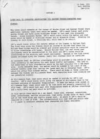
Photograph, Nightingale/Thompson Collection, 1916
From collection of Emma NIGHTINGALE, probably shows son 'William Henry Nightingale (1883 - 1971) who was an evangelist preacher with Church of Christ. The C/C college was in Glen Iris (now Monash freeway)Thompson collectionB/W photograph of large group of people standing in tiers (taken outside in garden setting)Handwritten on back of card: 'students of the College of the Bible, Glen Iris 1916'thompson collection, nightingale -
 Melbourne Tram Museum
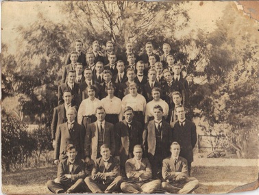
Poster, The Met, "Tram Diversion", 1986
Set of 12 Posters - printed on paper with an adhesive backing for: .1 - Tram Diversions - Bourke St - Moomba Mile footrace 28/2/1986 .2 - Moomba Festival Float Parade - gives diversions and alterations - for 10/3/1986 .3 - Anzac Day - 25/4/1986 .4 - Royal Show Parade - 14/9/1986 .5 - North Altona to City Service - Show Day 25/9/1986 .6 - Eastern Freeway - ditto .7 - Doncaster Routes - ditto .8 - William St Shuttle - not operating on nominated days during the Christmas New Year period .9 - LaTrobe St services - ditto .10 - Eastern Freeway - ditto .11 - Doncaster Routes - ditto .12 - North Altona to City Service All issued by Metropolitan Transittrams, tramways, moomba, showgrounds, royal show, anzac day, operations, latrobe st, william st, doncaster, buses, north altona -
 Greensborough Historical Society
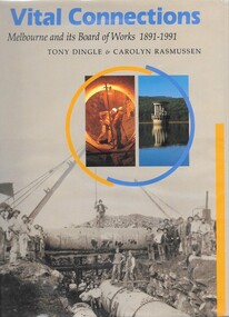
Book, Tony Dingle et al, Vital connections: Melbourne and its Board of Works 1891-1991, by Tony Dingle & Carolyn Rasmussen, 1991_
Centenary history of the Melbourne and Metropolitan Board of Works, the organisation responsible for Melbourne's water supply, sewerage and industrial waste disposal, town planning, rivers & creeks, metropolitan parks and building of freeways until its closure in 1992.432 p. hardback, black & white photographsmmbw, melbourne and metropolitan board of works -
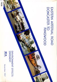 Whitehorse Historical Society Inc.
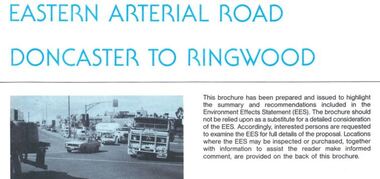
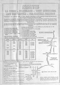
Book - Government Environment Effects Statement, Road Construction Authority (now part of VicRoads), Eastern Arterial Road - Doncaster to Ringwood, November 1987
The book covers the Environment Effects Statement for the Eastern Arterial Road Extension from Doncaster to Ringwood and the Ringwood Bypass. Aspects covered are development works, traffic affects, public transport, landscape and visual affects, noise, pedestrian/ bicycle access, lighting, air quality and construction affects. Includes maps, cross sections, photos.The book covers the Environment Effects Statement for the Eastern Arterial Road Extension from Doncaster to Ringwood and the Ringwood Bypass. Aspects covered are development works, traffic affects, public transport, landscape and visual affects, noise, pedestrian/ bicycle access, lighting, air quality and construction affects. Includes maps, cross sections, photos.non-fictionThe book covers the Environment Effects Statement for the Eastern Arterial Road Extension from Doncaster to Ringwood and the Ringwood Bypass. Aspects covered are development works, traffic affects, public transport, landscape and visual affects, noise, pedestrian/ bicycle access, lighting, air quality and construction affects. Includes maps, cross sections, photos.eastern freeway extension, eastern arterial road, mullum mullum creek, road construction, environmental impact -
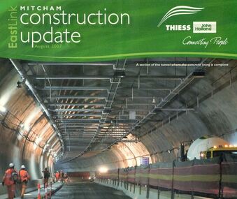 Ringwood and District Historical Society
Newsletter, Eastlink Mitcham Construction Update - August 2007
4-page A4 size colour brochure issued by Thiess John Holland as an information update on progress with tunnel construction works eventually linking the Eastern Freeway with Eastlink and Ringwood By-pass. (On 24 March 2008, Roads Minister Tim Pallas announced that the twin tunnels would be named "Melba" and "Mullum Mullum", the inbound and outbound direction respectively.) -
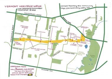 Ringwood and District Historical Society
Pamphlet - Map and Guide Notes, Vermont Heritage Walk, Vermont, Victoria - 2022
Double-sided A4 map and 9-page A4 guide notes with QR codes outlining historical and environmental points of interest for participants' walking tour of "Healesville Freeway Reserve" between Springvale Road and Boronia Road, Vermont, Vic - 3.5km, 50 minutes each way. Vermont Heritage Walk map and notes produced by Evie and Hardy Kielnhofer. -
 Kew Historical Society Inc
Photograph - Yarra Valley at Kew, 1918
During the nineteenth century, the land abutting the south side of the Yarra in Kew was devoted to dairy farming. In the twentieth century, before and after the construction of the Eastern Freeway, much of this low-lying area was used as golf courses and public parks.View of the farmland in the Yarra Valley at what is believed to be East Kew in 1918. Verso: "Willsmere / East Kew? / 1918"yarra river, yarra valley -
 Kew Historical Society Inc
Photograph - Yarra Valley at Kew, 1912
During the nineteenth century, the land abutting the south side of the Yarra in Kew was devoted to dairy farming. In the twentieth century, before and after the construction of the Eastern Freeway, much of this low-lying area was used as golf courses and public parks.Real-photo postcard of the farmland in the Yarra Valley in what is believed to be North Kew in 1912. Verso: "Willsmere / East Kew / 1912"yarra river, yarra valley, farming -- kew (vic.) -
 Kew Historical Society Inc
Photograph - Willsmere [Kew] Billabong, 1993
Willsmere Park is bounded by the the Yarra River, Green Acres Golf Club, Willow Grove and the Eastern Freeway. The land on which the park is now situated was bought by Thomas Wills at the Crown Land Sales of 1846 (Section 56). From the 1840s to the 1940s it was intensively farmed. The park is dominated by very large playing fields, while planting to the southern boundary was undertaken when the Eastern Freeway was built. It is only along the banks of the Yarra that there is any remnant native vegetation. Willsmere Park is of significance as an area of open land that remains from the flood plain that once dominated northern Kew. (Source: Kew Conservation Study, 1988)Original colour small format polaroid photograph of the 'Kew Billabong' in the Willsmere Park, taken on 16 September 1993."Willsmere Billabong 16.9.93"kew billabong, willsmere park, yarra river -- billabongs -
 Kew Historical Society Inc
Photograph - Yarra River in flood at the Willsmere Park, 1993
Willsmere Park is bounded by the the Yarra River, Green Acres Golf Club, Willow Grove and the Eastern Freeway. The land on which the park is now situated was bought by Thomas Wills at the Crown Land Sales of 1846 (Section 56). From the 1840s to the 1940s it was intensively farmed. The park is dominated by very large playing fields, while planting to the southern boundary was undertaken when the Eastern Freeway was built. It is only along the banks of the Yarra that there is any remnant native vegetation. Willsmere Park is of significance as an area of open land that remains from the flood plain that once dominated northern Kew. (Source: Kew Conservation Study, 1988)Original colour small format polaroid photograph of the Yarra River in flood at the Willsmere Park, taken on 16 September 1993."Yarra River at Willsmere Park Flooding 16.9.93"willsmere park, yarra river -- floods -- kew (vic.) -
 Kew Historical Society Inc
Photograph - Flooding in the Willsmere Park, 1993
Willsmere Park is bounded by the the Yarra River, Green Acres Golf Club, Willow Grove and the Eastern Freeway. The land on which the park is now situated was bought by Thomas Wills at the Crown Land Sales of 1846 (Section 56). From the 1840s to the 1940s it was intensively farmed. The park is dominated by very large playing fields, while planting to the southern boundary was undertaken when the Eastern Freeway was built. It is only along the banks of the Yarra that there is any remnant native vegetation. Willsmere Park is of significance as an area of open land that remains from the flood plain that once dominated northern Kew. (Source: Kew Conservation Study, 1988)Original colour small format polaroid photograph of flooding in the Willsmere Park, taken on 16 September 1993."Flooding of shared path from Willsmere Billabong 16.9.93"willsmere park, yarra river -- floods -- kew (vic.), kew billabong -
 Kew Historical Society Inc
Photograph - Flooding in the Willsmere Park, 1993
Willsmere Park is bounded by the the Yarra River, Green Acres Golf Club, Willow Grove and the Eastern Freeway. The land on which the park is now situated was bought by Thomas Wills at the Crown Land Sales of 1846 (Section 56). From the 1840s to the 1940s it was intensively farmed. The park is dominated by very large playing fields, while planting to the southern boundary was undertaken when the Eastern Freeway was built. It is only along the banks of the Yarra that there is any remnant native vegetation. Willsmere Park is of significance as an area of open land that remains from the flood plain that once dominated northern Kew. (Source: Kew Conservation Study, 1988)Original colour small format polaroid photograph of flooding in the Willsmere Park, taken on 16 September 1993."Flooding of Willsmere Park from Yarra 16.9.93"willsmere park, yarra river -- floods -- kew (vic.) -
 Kew Historical Society Inc
Photograph - Flooding of Willsmere Park from Yarra, 1993
Willsmere Park is bounded by the the Yarra River, Green Acres Golf Club, Willow Grove and the Eastern Freeway. The land on which the park is now situated was bought by Thomas Wills at the Crown Land Sales of 1846 (Section 56). From the 1840s to the 1940s it was intensively farmed. The park is dominated by very large playing fields, while planting to the southern boundary was undertaken when the Eastern Freeway was built. It is only along the banks of the Yarra that there is any remnant native vegetation. Willsmere Park is of significance as an area of open land that remains from the flood plain that once dominated northern Kew. (Source: Kew Conservation Study, 1988)Original colour small format polaroid photograph of flooding in Willsmere Park resulting from heavy rain on 15 September 1993."Flooding of Willsmere Park from Yarra 16.9.93"yarra river -- floods -- kew (vic.), willsmere park -
 Kew Historical Society Inc
Photograph - Willsmere [Kew] Billabong, 1993
Willsmere Park is bounded by the the Yarra River, Green Acres Golf Club, Willow Grove and the Eastern Freeway. The land on which the park is now situated was bought by Thomas Wills at the Crown Land Sales of 1846 (Section 56). From the 1840s to the 1940s it was intensively farmed. The park is dominated by very large playing fields, while planting to the southern boundary was undertaken when the Eastern Freeway was built. It is only along the banks of the Yarra that there is any remnant native vegetation. Willsmere Park is of significance as an area of open land that remains from the flood plain that once dominated northern Kew. (Source: Kew Conservation Study, 1988)Original colour small format polaroid photograph of Willsmere [Kew] Billabong on September 1993."Willsmere Billabong 16.9.93"yarra river -- floods -- kew (vic.), willsmere park -
 Ringwood and District Historical Society
Newsletter, Eastern Arterial Road Doncaster to Ringwood Environment Effects Statement Summary Brochure - November 1987
8-page A4 size brochure issued by Road Construction Authority reporting on the proposed extension of the Eastern Freeway between Doncaster and Ringwood. Topics include Community Consultation, Initial Four Lane Development, Estimated Capital Costs, Traffic Effects, Public Transport, Landscape Creek and Visual Aspects, Pedestrian/Bicycle Access, Noise, Air Quality, Lighting, Construction Impacts. -
 Melbourne Tram Museum
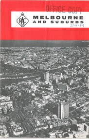
Map, Royal Automobile club of Victoria (RACv), "Melbourne and Suburbs", late 1960's
Map - folded 8 folds or sections, printed in two colours titled "Melbourne and Suburbs", published by the RACV late 1960's, giving a map of Melbourne and its suburbs, shows all tram and rail lines, highways, freeways under construction, has a detailed index and map of the city or CBD area, shows one way streets and churches, clubs etc.On front cover stamped "Office Copy" and hand written date of "28-1-69"trams, tramways, racv, melbourne, map, tramways, timetables -
 Eltham District Historical Society Inc
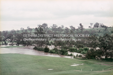
Slide, Floodwater, west from Clubhouse of Rosanna Golf Club, Lower Plenty, November 1971, 1971
Many parts of Melbourne flooded including Rosanna Golf Club, Lower Plenty in Novembere 1971. Many surburban roads, including the new south-eastern freeway were cut by flood waters. Here the level of the Plenty River floods onto the golf course. 35 mm colour positive transparency Mount - Agfacolor Service (Blue)floods, lower plenty, rosanna golf club, flooding, plenty river -
 Greensborough Historical Society
Newsletter, Greenhills and North Greensborough Progress Association, Community News: official journal of the Greenhills and Nth. Greensborough Progress Association. 20th Dec., 1972. Edition No. 10/72, 20/12/1972
This edition includes a report on the Progress Association's December 1972 meeting, Conservation in Greenhills and Diamond Valley in 1972, Letter to the Editor, Plenty River project, School news, The position with freeways in the Yarra Valley. A digital copy of this Newsletter is available from Greensborough Historical Society.Newsletter, 24 p., illus.greenhills and north greensborough progress association, greenhills -
 Melbourne Tram Museum
Ephemera - MMTB Notice - Eastern Freeway service, Melbourne & Metropolitan Tramways Board (MMTB), 12/1979
Notice to Passengers about the introduction of buses to and from La Trobe University running via the Eastern Freeway from the city via West Heidelberg and Northland from 3/12/1979. Gives information on services, times, stops, and conditions of travel and running times.Yields information about MMTB Bus services that used the Eastern Freeway to La Trobe university.A4 photocopy sheet folded into 8timetable, buses, public transport, eastern freeway, la trobe university