Showing 287 items
matching greensborough - maps
-
 Greensborough Historical Society
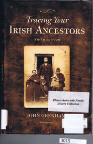
Book, Gill & Macmillan et al, Tracing your Irish ancestors, 3rd ed. John Grenham, 2006_
Hints on tracing Irish ancestors.526p., maps.family history, genealogy -
 Greensborough Historical Society
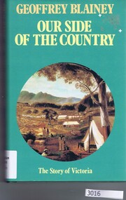
Book, Geoffrey Blainey et al, Our side of the country / Geoffrey Blainey, 1991_
A short history of Victoria.226p., maps.victoria history -
 Greensborough Historical Society
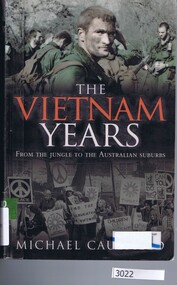
Book, Hachette, The Vietnam years: from the jungle to the Australian suburbs / Michael Caulfield, 2009_
The story of Australia's role in the Vietnam War and the lives of soldiers and their families on return to Australia.503p., illus., map.vietnam war -
 Greensborough Historical Society
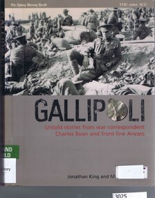
Book, Transworld Publishers, Gallipoli: untold stories from war correspondent Charles Bean and frontline Anzacs by Jonathan King and Michael Bowers, 2005_
Stories from C. E. W. Bean and photographs from Phillip Schuter.324p., illus., maps.world war 1, anzac legend, c e w bean, phillip schuter -
 Greensborough Historical Society
Book, Black Inc, The Australian victories in France / John Monash, 2015_
An account of the Australian battles in France in 1918, including the 1918 Battle of the Somme.327p., illus., maps.world war 1, the somme -
 Greensborough Historical Society
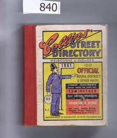
Book, Collins' Street Directory: Melbourne & suburbs 1951, 1951_
This 1951 street directory covers many Melbourne suburbs but not Greensborough. In the 1950s Greensborough was still a rural settlement. This directory is interesting for anyone wanting to check mid-20th century developments.A comprehensive coverage of suburban, inner city streets.Street directory. 411 pages, maps.melbourne, street directories -
 Greensborough Historical Society
Article, History of Plenty River Children's Cemetery; by Anne Paul, 1848-1860
The unmarked graves of the children of two Greensborough pioneer families lie in a private cemetery on the Plenty River. Burials occurred between 1848 and 1860.The significance lies in the association with two of the pioneer families of the Greensborough district. Descendants of both families still live in the area.2 printed pages of text, one page map (item 848).pioneer childrens cemetery, plenty river, partington, whatmough -
 Greensborough Historical Society
Article, Greenhills State School no.4893 (1962-1964): by Dawn Bennetts - GH4893, 1962-1964
Greenhills Primary School celebrated its 50 year anniversary and reunion in 2012. In this story, pupil Dawn Bennetts (nee Petts) recalls early memories of the school.Recalls early days at Greenhills Primary School. There appears to be few records surviving from the early days.2 pages of typed text. Copy 2 (3 Pages) amended with photographs and map of school.greenhills primary school, greenhills state school, dawn bennetts, dawn petts -
 Greensborough Historical Society
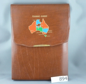
Road Maps, The Herald Road Guide, 1955-1956
Contains maps of Melbourne and surrounding areas as well as routes from Melbourne to other state capitals.Contains maps and descriptions of the Melbourne area in the era before the large scale urbanisation after 1960. Also includes country and day tour maps before highways were common.Book of road maps, 271 pages, in brown plastic carry case.maps, melbourne, victoria, day tours, touring maps -
 Greensborough Historical Society
Folder, Shire of Diamond Valley, Shire of Diamond Valley forms, 1980-1994
Forms, staff telephone lists, organisation charts, maps, administrative memos, directives and bulletins used by the Shire of Diamond Valley 1980s -1994.Arch file containing forms etc. used by the Shire of Diamond Valleyshire of diamond valley -
![Planning Document, Plan of proposed subdivision of land in Greensborough [Map shows Scotland house], 01/04/1971](/media/collectors/4f729f5697f83e03086015b8/items/5982a68921ea6b1420e4e560/item-media/59916fb521ea681094908d7a/item-fit-380x285.jpg) Greensborough Historical Society
Greensborough Historical SocietyPlanning Document, Plan of proposed subdivision of land in Greensborough [Map shows Scotland house], 01/04/1971
... Plan of proposed subdivision of land in Greensborough [Map... of land in Greensborough [Map shows Scotland house] Planning ...This subdivision of Greensborough shows the home of John Scotland (died 1888) and surrounding area bounded by Hailes, William, Lorimer, and Jessop Streets.Photocopy of plan, 2 pages.Part of plan (68G) of proposed subdivision of Greensborough, part of Crown Portion 18, Parish pf Keelbundora. Scale: 132 ft. to an inchjohn scotland, hailes street greensborough, william street greensborough, lorimer street greensborough, jessop street greensborough -
 Greensborough Historical Society
Book, Dorothy Williams, Monbulk: living in the Dandenongs, a social history, by Dorothy Williams, 1998_
History of Monbulk from early settlement in 1837 to 1997.Paperback, 325 p., black and white photographs, maps.monbulk, mount dandenong -
 Greensborough Historical Society
Book, Chris Cunningham, The Blue Mountains rediscovered: beyond the myths of early Australian exploration, by Chris Cunningham, 1996_
Written from both an historical and geographical view, this book tells the story of early inland exploration across the Blue Mountains.Paperback, 192 p., col. photographs, black and white maps.blue mountains nsw -
 Greensborough Historical Society
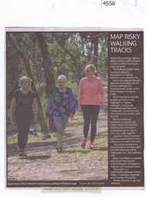
Newspaper Clipping, Diamond Valley Leader, Map risky walking tracks, 29/03/2017
Walkers are being urged to dob in dubious walking tracks in a bid to attract funding for improvements.News article 1 page, black text, colour image.walking tracks, walkspot project, womens walking wanderers -
 Greensborough Historical Society
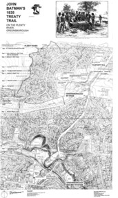
Map, Dennis Ward, John Batman's 1835 Treaty Trail on the Plenty River, 2010_
Map of the Plenty River through Greensborough and surrounding areas, annotated with historic places. Prepared by Dennis Ward, this map shows places of interest with historic markers for a proposed Heritage Trail along the Plenty. This was a joint project of Dennis Ward, Rotary Greensborough and Nillumbik Historical Society.This map shows many places of interest along the Plenty River. Large laminated map, including land subdivisions and street names.plenty river heritage trail -
 Greensborough Historical Society
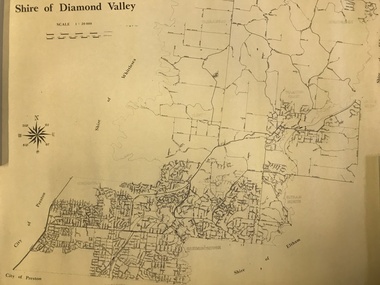
Map, Shire of Diamond Valley, 1964-1994
... Greensborough Historical Society 34A Glenauburn Road Lower ...Map of the former Shire of Diamond Valley, 1964-1994, showing the local government area from Greensborough to Hurstbridge.Map on yellowed paper.shire of diamond valley, greensborough, hurstbridge -
 Greensborough Historical Society
Map, Victoria. Department of Crown Lands and Survey, Keelbundoora; Counties of Bourke and Evelyn, 1950c
Map of the Victorian counties of Bourke and Evelyn showing parish boundaries and land ownership.Show the original landholders for this area.Map on light brown parchment, covered in plastic."L.5305" and "3462" -
 Greensborough Historical Society
Map, Green's subdivision of Greensborough, 1860c
... Copy of early map showing subdivision of Greensborough... greensborough Copy of early map showing subdivision of Greensborough ...This map shows the original subdivision of Greensborough by Edward Bernard Green. Some street names are different to today. This map shows the plan on which the town of Greensborough was based.Copy of early map showing subdivision of Greensborough. Black ink on white paper.edward bernard green, greensborough -
 Greensborough Historical Society
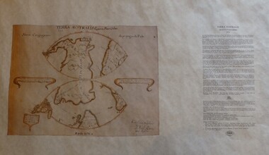
Map, Mapping Authority of NSW, Terra Australis: Quinta Pars Orbis, 1676_
The original of this map was drawn by an Italian priest Father Victorio Riccio in 1676 from knowledge brought to Manila on Dutch ships. Father Riccio was suggesting a Catholic mission to Terra Australia.Reproduction of an early map of Australia, pre-dating the voyages of Captain Cook.Facsimile map in cardboard protective tubeterra australis -
 Greensborough Historical Society
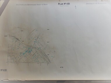
Map, Melbourne & Metropolitan Board of Works, MMBW Plan No.481, 23/09/1949
MMBW plan of part of central Greensborough, Main Street and surrounds, from sports ovals in North to Grimshaw Street in South.Map shows buildings and topography for the area.MMBW plan, black and colour ink on beige parchment, 2 copies."Scale:160 feet to 1 inch"melbourne and metropolitan board of works, mmbw, greensborough -
 Greensborough Historical Society
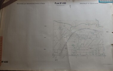
Map, Melbourne & Metropolitan Board of Works, MMBW Plan No.480, 17/10/1949
MMBW plan of part of central Greensborough, from Plenty River in North to Grimshaw Street in South, Sellars Street in West to Kerr Street in East.Map shows buildings and topography for the area.MMBW plan, black and colour ink on beige parchment, 4 copies."Scale:160 feet to 1 inch"melbourne and metropolitan board of works, mmbw, greensborough -
 Greensborough Historical Society
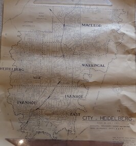
Map, City of Heidelberg. Engineers Dept, City of Heidelberg, 1960s
Map of the City of Heidelberg from the Yarra River in the South to North of Watsonia Military Camp. Shire of Diamond Valley is shown to the north.Map showing municipal and ward boundaries, black text on light brown paper."Scale: 20 CHS = to 1 IN"city of heidelberg -
 Greensborough Historical Society
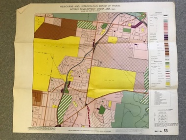
Map, Melbourne and Metropolitan Board of Works Interim Development Order 1961 Map No. 53, 27/09/1961
Denotes Zones and Reservations comprising part of the municipalities of Eltham, Heidelberg, Preston and Whittlesea, approved 27.9.61. Includes Mont Park Hospital and Watsonia Military Camp.Colour plan Date printed on plan (1959) has been over stamped with 1961. Also stamped with Government Gazette date of 27.9.1961. "Scale 800 feet to 1 inch"greensborough, watsonia -
 Greensborough Historical Society
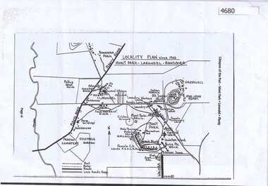
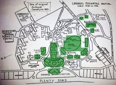
Map, Mont Park buildings still existing, 1946_
Locality Plan indicates buildings still existing within the Mont Park - Larundel mental health complex; Table lists 16 buildings by year built, initial purpose, subsequent uses and current address2 pages,one map, one table larundel, mont park -
 Greensborough Historical Society
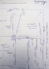
Map - Digital Image, Eric Barclay's Grace Park map, November 2016, 2016_11
Eric Barclay's Grace Park map, November 2016. Eric recalls the area around Grace Park from the late 1940s.Digital copy of black and white maperic barclay, barclay family, grace park -
 Greensborough Historical Society
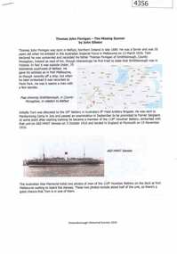
Document, John Gibson et al, Thomas John Finnigan - the missing gunner, 1914-1918
Article on the World War 1 service of Thomas Finnigan and the likelihood that he abandoned his wife and future child in Ireland when he took ship to Australia in 1915.6 p., colour images and mapthomas john finnigan, world war 1 project -
 Greensborough Historical Society
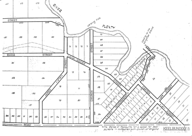
Maps, Greensborough. Parish Plan 1860, 1860c
... ? Greensborough. Parish Plan 1860 Maps ...This plan show Green's subdivision of Greensborough, north of Grimshaw Street.Enlargements of Parish plan circa 1860?One copy possibly from 1860, containing lot numbers for a government road, now Main Street, and surrounding streets.greensborough, grimshaw street greensborough, edward bernard green -
 Greensborough Historical Society
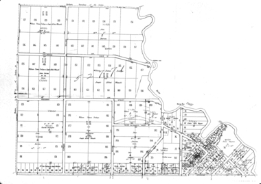
Map, Greensborough Map with Rail Line Plan, 1970s
... Greensborough Map with Rail Line Plan... Greensborough area Two copies of plan Greensborough Map with Rail Line ...Central Greensborough area, including railway line and some landowners. Basic map made c. 1902; annotations dated to circa 1970sTwo copies of planParish of Keelbundora, County of Bourke. Central Greensborough areagreensborough, greensborough railway station -
 Greensborough Historical Society
Photograph - Digital Image, Marilyn Smith, Larundel map and sign, 05/09/2017
This photograph shows the signs at the old Larundel site. Some buildings on this site are heritage listed on the Victorian Heritage Database.Digital copy of colour photographlarundel hospital -
 Greensborough Historical Society
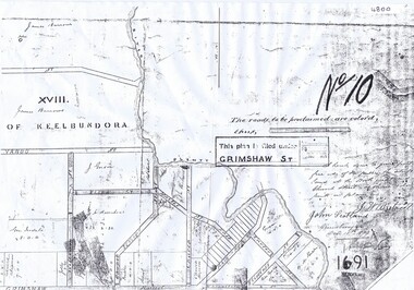
Plan, Parish Plan Map of Land North of Grimshaw Street, 11/12/1879
Part of Parish plan of land north of Grimshaw Street bounded by the Plenty River. Includes annotation signed by John Scotland and J. W. Britnell, dated Dec. 11th 1879.Photocopy of part of Parish plan of land north of Grimshaw Street bounded by the Plenty River. Includes annotation signed by John Scotland and J. W. Britnell, dated Dec. 11th 1879greensborough, grimshaw street greensborough, jonah britnell, john scotland