Showing 2951 items matching "highways"
-
 City of Moorabbin Historical Society (Operating the Box Cottage Museum)
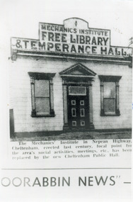
Photograph, Black & White, Cheltenham Mechanics Institute,Library, Temperance hall, c1960
The Mechanics Institute, built c 1890, was the focal point for the Cheltenham area's social activities, public meetings, adult education, etc. until its demolition 1960 when a new Cheltenham Hall was erectedThe early settlers erected this Mechanics Institute prior to 1900 as a public meeting place, library, temperance hall and it was used for social eventsBlack & White photograph in the Moorabbin News c 1960 showing the Mechanics Institute, c1900 Nepean Highway Cheltenhamcheltenham mechanics institute, cheltenham temperance hall, cheltenham church of christ, keys robert, lepage everet, moorabin news, leader newspapers, horse drawn carts, toll gates brighton, motor cars 1900, steam engines, early settlers, bentleigh, mckinnon, parish of moorabbin, city of moorabbin, county of bourke, moorabbin roads board, shire of moorabbin, henry dendy's special survey 1841, were j.b.; bent thomas, o'shannassy john, king richard, charman stephen, highett william, ormond francis, maynard dennis, market gardeners, vineyards, orchards -
 Lake Bolac & District Historical Society
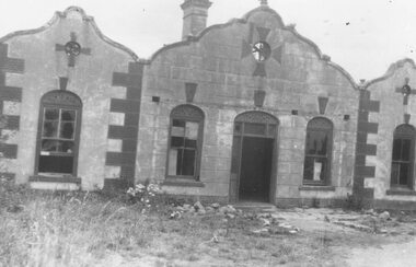
Black and white photograph, Second Lake Bolac Bush Nursing Centre
Second Lake Bolac Bush Nursing Centre on Glenelg Highway. Centre was in use from 1933 until 1957. -
 Whitehorse Historical Society Inc.
Map, Deep Creek Road, Mitcham, c1975
Enlargement of aerial photograph of area bounded by Dalmar Road, Cray Road, Glenvale Road and Maroondah Highway, MitchamEnlargement of aerial photograph of area bounded by Dalmar Road, Cray Road, Glenvale Road and Maroondah Highway, MitchamEnlargement of aerial photograph of area bounded by Dalmar Road, Cray Road, Glenvale Road and Maroondah Highway, Mitchamcray road, donvale, glenvale road, donvale, maroondah highway, mitcham, dalmor road, mitcham, deep creek road, mitcham, aerial photographs -
Whitehorse Historical Society Inc.
Legal record - Land Title, Springvale Road, 1960
Aerial photograph of cnr. Springvale Road and Burwood Highway, south past Highbury Road and east to Vermont South.Aerial photograph of cnr. Springvale Road and Burwood Highway, south past Highbury Road and east to Vermont South.Aerial photograph of cnr. Springvale Road and Burwood Highway, south past Highbury Road and east to Vermont South.aerial photographs, springvale road, burwood east, burwood highway, burwood east, highbury road, burwood east, vermont south -
 Whitehorse Historical Society Inc.
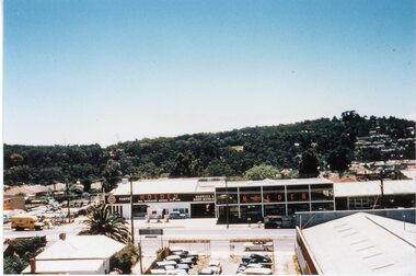
Photograph, Mitcham Shopping Centre, 1/04/2001 12:00:00 AM
Coloured photograph of Maroondah Highway Mitcham looking south along Station Street from corner of Britannia Mall.maroondah highway, mitcham, station street, britannia mall mitcham -
 Whitehorse Historical Society Inc.
Article, Family to Sell Burwood One, 2018
After being owned by a single family for 26 years, Burwood One, 172-210After being owned by a single family for 26 years, Burwood One, 172-210 Burwood Highway is for sale.After being owned by a single family for 26 years, Burwood One, 172-210 burwood one, burwood highway, burwood, nos. 172-210 -
 Whitehorse Historical Society Inc.
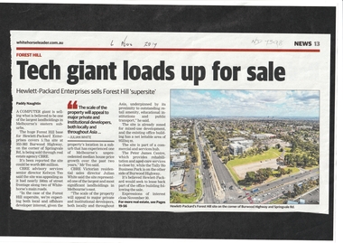
Article, Hewlett - Packard Site, 2017
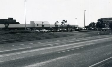
The Hewlett Packard site at 353 -383 Burwood Highway, Forest Hill which covers 5.7 ha is for sale.hewlett packard, forest hill, burwood highway, forest hill no. 353 -383 -
 Whitehorse Historical Society Inc.
Photograph, Vermont South Shopping Centre, 1985
Black and white photo of the south side of Vermont South Shopping Centre taken in 1985 from Burwood Highwayvermont south shopping centre, shopping centres -
![Photographs [Series], Noel Kelly, Chandler Highway Bridge Construction, August 2018, 07/08/2018](/media/collectors/550653872162f11fb04854aa/items/5c2f545421ea670d20799ebb/item-media/5c2f54c721ea670d207a1d1c/item-fit-380x285.jpg) Kew Historical Society Inc
Kew Historical Society IncPhotographs [Series], Noel Kelly, Chandler Highway Bridge Construction, August 2018, 07/08/2018
The second of a series of photographs taken in July/August 2018 recording work on the old and new Chandler Highway Bridges.chandler highway bridge -
 Wodonga & District Historical Society Inc
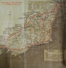
Map - Hamilton-Smith Collection Highway Map c. mid 1900s
The Hamilton-Smith collection was donated by the children of Grace Mary Hamilton-Smith nee Ellwood (1911-2004) and William John (Jack) Hamilton-Smith (1909-1984) who settled in Wodonga in the 1940s. The Ellwood family had lived in north-east Victoria since the late 1800s. Grace’s mother, Rosina Ellwood nee Smale, was the first teacher at Baranduda in 1888, and a foundation member of the C.W.A. Rosina and her husband Mark retired to Wodonga in 1934. Grace and John married at St. David’s Church, Albury in 1941. John was a grazier, and actively involved in Agricultural Societies. The collection contains significant items which reflect the local history of Wodonga, including handmade needlework, books, photographs, a wedding dress, maps, and material relating to the world wars.This item has well documented provenance and a known owner. It forms part of a significant and representative historical collection which reflects the local history of Wodonga. It contributes to our understanding of social life in mid-twentieth century Wodonga, as well as providing interpretative capacity for themes including local history and social history.A brown and tan highway map with red road markings showing the south east of Australia from Melbourne to Sydney map, highway, wodonga, melbourne, sydney, travel, hamilton-smith, hamilton-smith collection, driving, drive, car, road -
 Lakes Entrance Historical Society
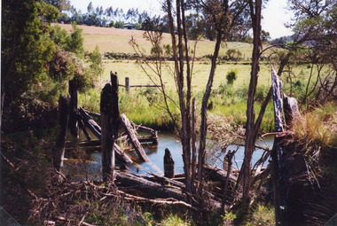
Photograph, 1998
Colour photograph of the remains of a timber bridge on the former Princes Highway at Toorloo Arm Road, Lake Tyers, Victoriabridges, waterways -
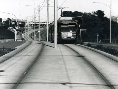 Whitehorse Historical Society Inc.
Photograph - B/W Photograph, Tram on Burwood Highway East Burwood, 1994
Black and white photograph of a tram on the Burwood Highway, coming east from the Middleborough intersection and shopping centre. 1994burwood highway blackburn south, trams -
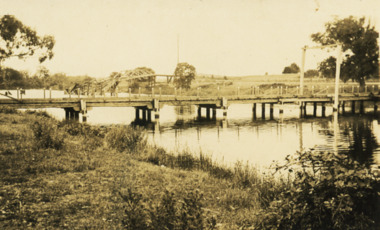 Lakes Entrance Historical Society
Photograph - Swan Reach Bridge, 1926 c
Black and white photograph of temporary bridge at Swan Reach collapsed highway bridge in background Swan Reach Victoriawaterways, bridges -
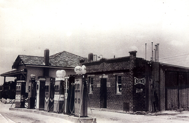 Whitehorse Historical Society Inc.
Photograph - B/W Photograph, McLean's Garage, East Burwood, mid 1930s
Black & white photo of McLean's Garage on the corner of Burwood Highway and Middleborough Roads East Burwood in mid 1930smclean's garage, east burwood -
 Ringwood and District Historical Society
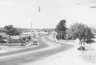
Photograph, Maroondah Highway East, Ringwood- 1969. Looking west towards Ringwood up from Ringwood Lake
Black and white photographImage shows Ringwood Mail Office on south side of Highway. -
 Ringwood and District Historical Society
Photograph, Bill Patterson Motors -Ringwood- circa 1960's
Postcard size colour photograph'Written on back of photograph" Bill Patterson Motors - Maroondah Highway -
 Ringwood and District Historical Society
Photograph, The Rest" tea rooms, Maroondah Highway, opposite Heatherdale Road
Black and white photograph of old brick building with scalloped roof-line. Decorative bricks in various places, particularly on top of windows and door.'The Rest' tea rooms, Maroondah Highway, opposite Heatherdale Road. -
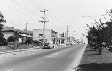
 Ringwood and District Historical Society
Photograph, Maroondah Highway West, Ringwood- 1960. Looking east from Heatherdale Road
Black and white photographWritten on back of photograph: "Maroondah Highway coming into Ringwood, 1960". -
 Ringwood and District Historical Society
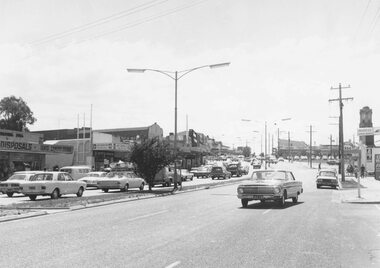
Photograph, Maroondah Highway West, Ringwood- 1973. Easterly view towards the clock tower
Black and white photographWritten on back of photograph: "Maroondah Highway looking east, 1973". -
 Ringwood and District Historical Society
Photograph, Railway Place, Ringwood, 1969
Black and white photograph Image shows shops on corner of Maroondah Highway and Ringwood Place. -
 Ringwood and District Historical Society
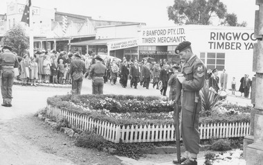
Photograph, Anzac Day at Ringwood clock tower, 3/5/1956
Black and white photographImage shows procession marching in Maroondah Highway approaching clocktower. -
 Ringwood and District Historical Society
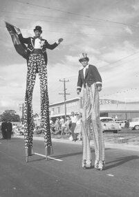
Photograph, City of Ringwood celebrations, 1960
Black and white photographImage shows a man and boy on stilts in procession on Maroondah Highway. -
 Ringwood and District Historical Society
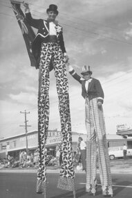
Photograph, City of Ringwood celebrations, 1960
Black and white photographImage shows a man and boy on stilts in procession on Maroondah Highway. -
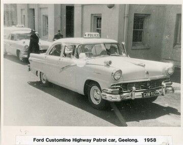 Victoria Police Museum
Photograph (police car)
Ford Customline Highway Patrol car, registration number GVM 912, at Geelong with divisional van in the background. Circa 1958police vehicles; wireless patrol; motor transport branch; motor transport section; ford customline car -
 Ringwood and District Historical Society
Photograph-B&W, Joan Walker, East Ringwood 2000-Burnt Bridge Shopping Centre, Maroondah Highway, 2000
East Ringwood 2000-Burnt Bridge Shopping Centre, Maroondah Highway- B&W Photo from Album 6501 -
Whitehorse Historical Society Inc.
Article, Our changing landscape, 1986
Article re Tally Ho farm property on Burwood Highway. In 1986 Nunawading's high tech park subdivision will commence.Article re Tally Ho farm property on Burwood Highway. In 1986 Nunawading's high tech park subdivision will commence.Article re Tally Ho farm property on Burwood Highway. In 1986 Nunawading's high tech park subdivision will commence.land subdivision, tally ho -
Whitehorse Historical Society Inc.
Map, Aerial photograph, c1950
Arial photo of Vermont South and Burwood East, Middleborough Road, Burwood Highway, Springvale Road, Highbury Road and environs.Aerial photo of Vermont South and Burwood East, Middleborough Road, Burwood Highway, Springvale Road, Highbury Road and environs.Arial photo of Vermont South and Burwood East, Middleborough Road, Burwood Highway, Springvale Road, Highbury Road and environs.vermont south, burwood east, aerial photographs -
Whitehorse Historical Society Inc.
Map, Springvale Road, 1987
Aerial photograph of cnr Springvale Road and Burwood Highway, south past Highbury Road and west past Blackburn Road.Aerial photograph of cnr Springvale Road and Burwood Highway, south past Highbury Road and west past Blackburn Road.Aerial photograph of cnr Springvale Road and Burwood Highway, south past Highbury Road and west past Blackburn Road.aerial photographs, blackburn road, burwood east, highbury road, burwood east, burwood highway, burwood east, springvale road, burwood east, burwood east -
 Whitehorse Historical Society Inc.
Photograph, Mitcham Hotel, 2012
Coloured photograph showing the Mitcham Hotel situated on the south -east corner of Mitcham Road and Maroondah Highway. Parking at the rear.mitcham hotel, hotels -
 Whitehorse Historical Society Inc.
Photograph, Vermont South Community House, 1976
Black and white photograph of the South Vermont Community House at 557 Burwood Highway, Vermont South, opened in October 1976vermont south community house, community houses, burwood highway, vermont south, neighbourhood houses