Showing 982 items matching "homestead."
-
 Eltham District Historical Society Inc
Photograph - Digital Photograph, Alan King, Edendale Farm Homestead, 29 January 2008
Edendale Farm is Nillumbik Shire Council's environment centre situated in Gastons Road, Eltham between the railway and the Diamond Creek. The homestead on the property was built in 1896 and is of historical significance, being the subject of a Heritage Overlay under the Nillumbik Planning Scheme. The Edendale property was originally part of an extensive land purchase in 1852 from the Crown by pioneer Eltham farmer Henry Stooke. He initially purchased 51 acres and later expanded his holdings by purchasing another three adjacent Crown allotments extending northerly from Josiah Holloway's Little Eltham subdivision. Despite clearing the land, Stooke did not build on this property, choosing to live on his property "Rosehill" at Lower Plenty. In 1896 Thomas Cool, Club Manager of the Victoria Coffee Palace in Melbourne purchased 7 acres of the original Stooke land and built the house now known as Edendale. Cool did not farm the land, instead using it as a gentleman’s residence, retiring to Eltham at weekends. In 1918 he purchased an additional 7 acres but in 1919 he sold the property. Later owners included J.W. Cox, the Gaston family and D. Mummery. In the 1980s the Eltham Shire Council purchased the site for use as a Council depot, but this use did not proceed. Subsequently, it was used as the Council pound. The Edendale Farm Pet Education and Retention Centre was established in the summer of 1988/1989 and was set up to replace the existing dog kennels with a high standard pet retention centre. The design style of the building was established to compliment the features of the existing house. It was equipped with 10 retention pens, a veterinary room and a pet education area where school children and other interested parties learnt about pet care procedures. It was later developed into a community farm and was run by an advisory committee and in 2000 it became an Environment Centre. In early 2006 an advisory committee was established for the development of a master plan for future development at Edendale Farm. The committee included Russell Yeoman, a former long-time shire planner and founding member of the Eltham District Historical Society. At the time of filming the Master Plan and future for Edendale was about continuing to develop Edendale as a centre of environment learning and looking at expanding displays and school program, running a lot more of life-long learning and workshops around sustainable living. Covered under Heritage Overlay, Nillumbik Planning Scheme. Published: Nillumbik Now and Then / Marguerite Marshall 2008; photographs Alan King with Marguerite Marshall.; p101 A sharp turn from busy Wattletree Road by the railway line, brings a surprise. Only 1.4 km from Eltham’s centre, sheep feed, blissfully unaware of the hectic suburban activity so close by. At the entrance to the 5.6ha Edendale Farm is another surprise. A work of art that looks like huge tree trunks transformed into bowler and top-hatted men. The Fences Act 1968 by Tony Trembath with Mark Cain and John Doyle, 1996, is classified by the National Trust of Australia as having Regional Significance. The title refers to a government act on disputes between neighbors over the placement of fences and boundaries. This takes a ‘wry swipe’ at a community divided by trivial squabbles. It also celebrates making do with limited resources.1 Further along on the left, the office wall is decorated with a massive Eltham Copper Butterfly, designed by Robert Tickner and made by school children with used plastic bottles and other waste material. Nillumbik Council runs Edendale as an Environmental Education Centre, to help preserve and enhance the local environment. As early as 1988 the former Eltham Shire Council realised Edendale’s importance in meeting people’s needs, particularly of children, to enjoy farmland. The centre, with the Eltham North Reserve to the north - including remnant bushland and open parkland - makes up the major part of the public open space for this area. The council considers this area will become increasingly important to the local community for recreational use.2 Educational programs aim to encourage community involvement to ensure the long-term rehabilitation and protection of natural bushland areas. Edendale is used by people of all ages - from school children to adults - for environmental programs and workshops, as well as for recreation, to enjoy the domestic animals and to picnic. Edendale is also home to the Environmental Works staff who manage reserves and roadsides and support Nillumbik Friends environmental groups. The Friends propagate plants at the nursery, which grows indigenous plants and sells these to the public.3 The centre demonstrates the sustainable living the farm teaches, with features like solar hot water and drive lighting and for the fireplace, logs of recycled cardboard. Edendale has had a varied history as a dog pound and even as a retreat for Thomas Cool, Club Manager of the Victoria Coffee Palace in Melbourne. His single-storey weatherboard house built in 1896, which still stands, was grander than most homes in Eltham. Although such buildings were common in many other parts of Melbourne, Eltham’s poverty and remoteness did not encourage such construction. The Victorian rectangular-shaped house, with a corrugated iron roof and veranda, has elegant large rooms, leadlight windows, ceiling roses, two bay windows and ornately carved wooden fireplace surrounds. Cool bought seven acres (2.8ha) from pioneer Eltham farmer Henry Stooke’s 200 acre (81ha) farm, which he had bought from the Crown in 1852. In 1918 Cool bought an extra seven acres (2.8ha) but in 1919 sold the estate to farmer John Cox. In 1933 Cox sold Edendale to Mrs Elizabeth Gaston, after whom the road leading to the centre was named. The property was owned by several Gaston family members, who called it Edendale, then by a police constable, Douglas Mummery, until the Shire of Eltham bought it in 1970. Oddly Edendale was known as Mummery’s for almost 20 years, although Mummery owned it only for a short time.4 The shire used Edendale as a dog pound until amalgamation with other municipalities in 1996. The pound then moved to the Yan Yean Road, Plenty site, which had been used by the former Diamond Valley Shire Council. To the west and north the centre is bounded by Diamond Creek and on the east by the Melbourne-Hurstbridge railway line. Part of the Research creek forms the centre’s southern boundary.This collection of almost 130 photos about places and people within the Shire of Nillumbik, an urban and rural municipality in Melbourne's north, contributes to an understanding of the history of the Shire. Published in 2008 immediately prior to the Black Saturday bushfires of February 7, 2009, it documents sites that were impacted, and in some cases destroyed by the fires. It includes photographs taken especially for the publication, creating a unique time capsule representing the Shire in the early 21st century. It remains the most recent comprehenesive publication devoted to the Shire's history connecting local residents to the past. nillumbik now and then (marshall-king) collection, edendale farm -
 Hume City Civic Collection
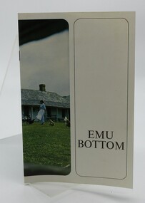
Booklet, The Ruskin Press PTY LTD, EMU BOTTOM
Book containing information about the Emu Bottom Homestead with some coloured and black and white photographs. The homestead operated as a wedding venue or for other special events and was also opened to the public at various times when Hedley and Jan Elliott owned the property The property was also known as "Holly Green" at one stage.Small paperback booklet with an image of Emu Bottom homestead on the cover with a woman and chickens on front lawn.EMU BOTTOMemu bottom, george evans, emu bottom homestead, sunbury -
 Lakes Entrance Historical Society
Photograph - Home Hardware, 1993
Home Hardware previously Homestead Hardware Esplanade through to Gray Street 1993Black and white photograph of Paul Hasler of Home Hardware previously Homestead Hardware Lakes Entrance Victoriabusinesses, hardware -
 Hume City Civic Collection
Photograph, 1937
When this photo was taken "Holly Green" as it was called then was owned by the Webb family. It was originally called "Emu Bottom" when the Evans family owned the property and re-named "Emu Bottom" when Hedly Elliot acquired it in the 1960s.A mounted black and white photograph of "Holly Green". There is a picket fence with a stone wall entrance on either side of a cyclone gate in the foreground. The fountain is on the LHS and a flowerbed on the RHS. The homestead is beyond the lawn. The mount is buff coloured with an inscription underneath the photo in gothic script.HOLLY GREEN / VICTORIA'S OLDEST HOMESTEAD AT THE AGE OF 101 YEARS / SUNBURY, 1937holly green, emu bottom, fences, fountains, sunbury, evans, george, webb, harry, stringer, esme, elliot, hedley, oldest house, house names, 1930s, george evans collection -
 Phillip Island and District Historical Society Inc.
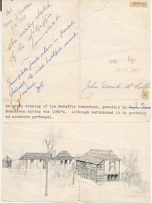
Drawing, 1860's
One of a collection of photographs and drawings donated by Mr J. W. Gliddon and used in his book "Phillip Island in Picture and Story"An early drawing of the McHaffie homestead, possibly by J. B. Henderson during the 1860's. Although unfinished it is probably an accurate portrayal."An early sketch of the McHaffie homestead" "Incomplete parts shown in pencil. Probably the most truthful record extant. J. W. G." "John David McHaffie."mchaffie homestead, phillip island, mr. j. w. gliddon -
 Greensborough Historical Society
Photograph - Digital Image, Willis Vale site, 2014_
Photograph of the site of the 'Willis Vale' homestead, home of the Partington family. The derelict Willis Vale house was destroyed in 1964 when a fire originating from North Plenty Gorge - Kurrak Road - was lit by two teenage boys and made its way several kilometres down to Partington's Flat Greensborough.Digital copy of colour photograph."This house is where Willis Vale homestead was on Partingtons Flat"partington family, willis vale -
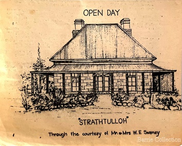 Melton City Libraries
Drawing, Open Day at Strathtulloh, Unknown
"Strathtulloh, 1402-1600 Greigs Road, Melton South, is significant as an early property in Victoria, retaining different eras of pioneering dwellings, ranging from a ruin to a fine Colonial style homestead. The property has close historical association with the early settlement of the Melton district, and was owned by the Henty family in the 1840s. The Strathtulloh property was alienated by the Crown in 1840 to Charles James Garrard, who sold it in 1848 to Charles and Stephen Henty, whose sister Jane and her husband Samuel Bryan lived there in the late 1840s. In 1853 the property then passed to William Tulloh, after whom the homestead was named. A primitive bluestone ruin of near the Toolern Creek, built of vesicular bluestone and mud mortar, is of unknown origin. It has commonly been assumed to pre-date 1840, and to have belonged to the original holder of the Exford lease, Dr Watton or Port Phillip Association member Dr Cotterill. This is unlikely, as the 1841 census records Dr Watton, and everyone else in the district, as living in a ‘wood’ dwelling. It may instead have been the residence of Garrard, and the Bryans, in the 1840s and an early map names a site near here as ‘Bryan’s outstation’. It is assumed that the two-level stone building that became the kitchen is the earliest intact building on the site, and was the first homestead; it is likely to date to the 1840s or 1850s. The main homestead is a substantial villa constructed of random coursed bluestone, with a verandah facing three sides, attic bedrooms with dormer windows, a fan light over the front door, a hipped roof originally clad in slate, and a large cellar. Although demonstrating characteristics of pioneering construction, such as unworked log beams, pit sawn beams, hand-sawn lintels and colonial door locks, documentary evidence shows that it was built c.1869. The homestead has now been structurally repaired and decoratively restored; a sympathetic new semi-detached rear extension was added in the early years of the 21st century. The former kitchen building has also undergone minor repairs and alterations". Strathtulloh Homestead at 1402-1600 Greigs Road, Melton Southlocal architecture -
 Lakes Entrance Historical Society
Postcard, Whiters Camp Park, 1935c
The Homestead, L C P Furnished Apartments have become very popular (on back)Black and white small format postcard of the Homestead at Whiters Camp Park. A timber and fibro cement building in Californian bungalow style. Low pitched gable roof with built in veranda extensions. Homestead was the residence of the proprietor and family. Formal garden in foreground image. Lakes Entrance Victoriatourism, houses, resort -
 Camperdown & District Historical Society
Photograph - ''Wuurong'' homestead, Camperdown, c1870s
"'Wuurong'' homestead (originally 'Basin Banks') was built c1867 by Donald McNicol (1812-1903) shepherd, store owner and pastoralist. The property was leased c1870 by James Dawson (1806-1900) Guardian of the Aborigines, pastoralist and environmentalist. James Dawson renamed the property 'Wuurrong'. His daughter, Isabella Park Dawson (1842-1929), recorded the languages and customs of Western Victorian First Nations people and together with her father, published the book "Australian Aborigines" (1881).Black and white photograph of ''Wuurong'' homestead Front: An Early Photograph of "Wuurrong" Built By Donald McNicolcamperdown, cdhs, wuurong, djargurd wurrung, djargurdwurrung, cdhsfirstnations -
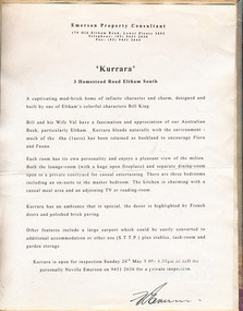 Eltham District Historical Society Inc
Leaflet, Kurrara, 3 Homestead Road, Eltham South, 1991, 1991
Contained in Volume 1 of a set of two spiral magnetic photo albums, each containing 10 leaves, 20 pages; Vol. 1 labelled "Houses - Eltham South" and Vol. 2 labelled "Eltham Houses". Leaflet promoting house auctioneltham, eltham south, real estate advertisement, houses, kurrara, neville emerson real estate -
 Eltham District Historical Society Inc
Newsclipping, 16 Homestead Road, Eltham South
Contained in Volume 2 of a set of two spiral magnetic photo albums, each containing 10 leaves, 20 pages; Vol. 1 labelled "Houses - Eltham South" and Vol. 2 labelled "Eltham Houses". Newspaper clippings promoting house auctioneltham, real estate advertisement, houses, homestead road, stockdale and leggo -
 Phillip Island and District Historical Society Inc.
Book, COX, Philip et al, Australian homestead, 1972
Stamped 'Cowes Public Library'.farmhouses, australia, architecture, domestic, historic buildings, farm buildings -
Phillip Island and District Historical Society Inc.
Book, Frankston Historical Society, Ballam Park Homestead, 1999
ballam park homestead, history, historic buildings, victoria, ballam, structures, history -
 Greensborough Historical Society
Booklet, Barbara Rielly, Viewbank Homestead 1837-c.1922: uncovering our past for the future, 1999
Contains biographical notes on James and Isabella Williamson, first purchasers of the site about 1840, with newspaper clippings and photographs9p. booklet, text, black and white and colour photographs. 3 copiesviewbank homestead, williamson family -
 Phillip Island and District Historical Society Inc.
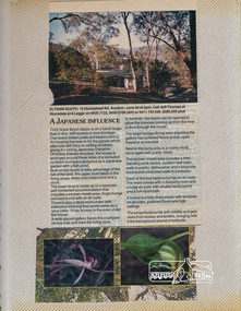
Photograph, Anderson Family & Homestead, 1888
Built in 1868 for Boarding House. Added to in 1887 - 88. Sold when Robert Anderson's second wife died. Several owners but came back into the family with Grandson Stan Anderson. Sold again when Stan died. Glen Isla now owned by Mr & Mrs Lunn who have restored it to its present condition. Now owned by Mr & Mrs Baker - 2018.House built in 1868, to become a Boarding House. A 2-story weatherboard building with brick chimney and filials at each point of gabled roof. Long windows. Attached at back and far side 2 single story joined gable roof buildings and adjoining wooden lattice building. Back yard white picket fence. 5 Figures out front. Built by Robert Andersonlocal history, photographs, buildings, historic., glen isla homestead, phillip island, black & white photograph, mrs emma anderson jacobs, robert coxon anderson -
 Phillip Island and District Historical Society Inc.
Foreword, Anderson Family & Homestead, 1994
A brief summary of The Anderson Family History from arrival of early pioneer Robert Coxon Anderson on the Island.Summary of the Anderson Family History, Robert Coxon Anderson and Glen Isla.local history, documents-family history, history of family - buildings the anderson family, phillip island, black type on white paper, mrs emma anderson jacobs, family history -
 Phillip Island and District Historical Society Inc.
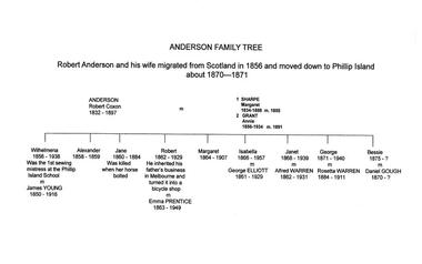
Family Tree, Anderson Family & Homestead, 1980
Robert Anderson and wife migrated to Australia in 1856 and moved to Phillip Island about 1870 - 71. His descendants are tabulated with some brief history of them. On one Family Tree it has that Robert Coxon Anderson married Margaret Sharpe in 1855 then Bessy Flemming after Margaret died. In another Family Tree the 2nd wife is noted as Annie Grant marrying Robert in 1891. The above Family Tree has been changed to Annie Grant.The Anderson' Family Treelocal history, documents, family history, family descendants from robert anderson, phillip island, hand printed in ink on white paper, mrs emma anderson jacobs, anderson family tree -
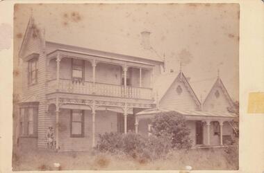 Phillip Island and District Historical Society Inc.
Photograph, Anderson Family & Homestead, 1888
Built 1868 for Boarding House. Additions in 1887 - 88. Sold when Robert Anderson's second wife died. Several subsequent owners, back into Anderson Family with Grandson Stan Anderson. Sold again when Stan died. Glen Isla sold to Mr & Mrs Lunn who have restored it to its present condition. Now owned and run as a Boutique B & B by Ian & Madeleine Baker - as at 2019.Photograph of full front view of 2-story weatherboard house with gable roof. Filials at each point of gabled roof. Upstairs wrought iron verandah. Twin gable roofed. Single story adjoined buildings, wooden, wrought iron verandah. figure of woman and large bush in front, one brick chimney.local history, photography, photographs, slides, film, buildings, historic, glen isla homestead, phillip island, black & white photograph, mrs emma anderson jacobs, homesteads -
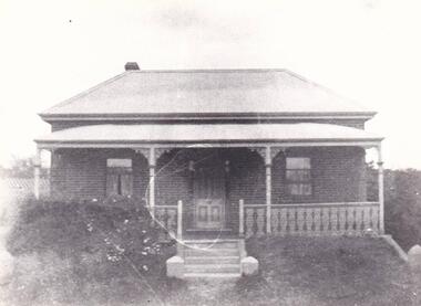
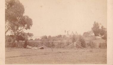 Phillip Island and District Historical Society Inc.
Photograph, Anderson Family & Homestead
Glen Isla built in 1868 by Robert Anderson, additions 1987 - 88. Had several owners subsequently, bought again into family by Grandson Stan Anderson but sold when he died. Now owned and restored by Mr & Mrs Lunn.Distant view of Glen Isla House depicting rural setting and Western Port Bay glimpse in background.local history, photography, photographs, slides, film, glen isla house, phillip island, sepia photograph, mrs emma anderson jacobs -
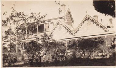 Phillip Island and District Historical Society Inc.
Photograph, Anderson Family & Homestead, 1887
Two early Photographs of Glen Isla Home in garden setting. No specific date. Taken from 2 different angles.Two-story Weatherboard Gabled House - Glen Isla - in early years.local history, photography, photographs, slides, film, buildings, historic, the house - glen isla - in early years, phillip island, sepia photograph, mrs emma anderson jacobs -
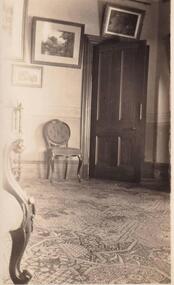
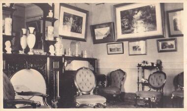
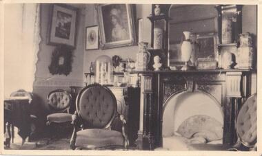 Phillip Island and District Historical Society Inc.
Photograph, Anderson Family Homestead, 1868
Drawing Room of Glen Isla showing beautiful Antique furniture. Large mirror above Marble Fire Place. Shelves with Porcelain Vases. Two Marble busts, open Fan in Hearth. Many Photographs on walls.Interior Photograph of Glen Isla Drawing Roomlocal history, photography, photographs, slides, film, buildings, historic, glen isla drawing room, phillip island, sepia photograph, mrs emma anderson jacobs -
 Phillip Island and District Historical Society Inc.
Photograph, Anderson Family Homestead, 1868
Small section of Glen Isla Drawing Room, open door and patterned floor covering.Small section of Drawing Room - Glen Islalocal history, photography, photographs, slides, film, buildings, historic, glen isla drawing room, sepia photograph, mrs emma anderson jacobs -
 Phillip Island and District Historical Society Inc.
Photograph, Anderson Family Homestead, 1868
Drawing Room of Glen Isla showing beautiful Antique furniture. Large mirror above Marble Fire Place. Shelves with Porcelain Vases. two Marble busts, open fan in Hearth. Many Photographs on walls.Interior Photograph of Glen Isla Drawing Roomlocal history, photography, photographs, slides, film, buildings, historic, glen isla drawing room, phillip island, sepia photograph, mrs emma anderson jacobs -
 Phillip Island and District Historical Society Inc.
Photograph, Anderson Family Homestead
Not knownSingle fronted Brick Cottage, corrugated iron roofing. One Chimney on left. Two front windows. Wooden front door. Wrought iron balustrade and on top of posts attached to Porch. Five steps up to Verandah and direct to front door. Anderson's bricks used for the house.local history, photography, photographs, slides, film, buildings, historic, cottage, black & white photograph, mrs emma anderson jacobs -
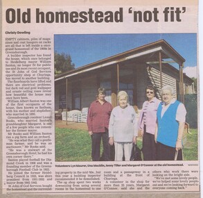 Greensborough Historical Society
Newspaper Clipping - Digital Image, Old homestead 'not fit', 2000c
The old house at Churinga, once owned by William Santon, and now used by the Churinga Opportunity Shop has been declared unsafe for public use.Digital copy of news article 1 page, black text and colour imagewilliam santon, churinga, saxam -
Greensborough Historical Society
Article, Noel Withers, Willis Vale Homestead 1841-1962, 1841-1962
Willis Vale was built in 1841 by George Maygar and named after his wife's maiden name of Willis. This article outlines the lessees and owners of the property, Robert Whatmough (1863) and Charles Partington (1878).Outlines the history of this Greensborough property.3 pages, text and black and white imageswillis vale, robert whatmough, george maygar, charles partington -
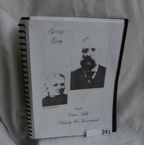 Greensborough Historical Society
Folder, George Gray and the 'Cleir Hills' nursery and homestead, 1813o
Family history by Kay Walker, great grand-daughter of George and Jane Gray. The Gray family were the owners of the 'Cleir Hills' nursery in Cottlesbridge.George Gray's parents lived in Greensborough in the 1850s. His father Owen was a local storekeeper.Spiral bound folder with clear cover. Approx 40 photocopied pages of Gray family history.gray family, george gray, cleir hills, cottlesbridge -
 Eltham District Historical Society Inc
Photograph, Stevenson Homestead "Bankhead", Kangaroo Ground. Robert Stevenson and family
Stevenson, Robert, Kangaroo Ground, was born in the County of Evelyn, Victoria in 1845, He is the son of the late Joseph Stevenson and retains the property purchased by his father, with 47 acres adjoining, making in all 127 acres, where he carries on farming, and also a vineyard, the grapes from which have taken a number of prizes at agricultural societies’ shows at Heidelberg and other places. He was married in 1872, and has a family of two sons and five daughters. From: Victoria and it’s Metropolis: Past and Present by Alexander Sutherland ; R. L. J. Ellery ...[et.al. Melbourne : McCarron, Bird, 1888]. Page. 414 This photo forms part of a collection of photographs gathered by the Shire of Eltham for their centenary project book,"Pioneers and Painters: 100 years of the Shire of Eltham" by Alan Marshall (1971). The collection of over 500 images is held in partnership between Eltham District Historical Society and Yarra Plenty Regional Library (Eltham Library) and is now formally known as the 'The Shire of Eltham Pioneers Photograph Collection.' It is significant in being the first community sourced collection representing the places and people of the Shire's first one hundred years.Digital imagesepp, shire of eltham pioneers photograph collection, kangaroo ground, bankhead, robert stevenson, stevenson homestead -
 Eltham District Historical Society Inc
Photograph, "Pretty Hill", Kangaroo Ground. James Johnston's homestead
Kangaroo Ground pioneers James Johnston (died 1895) with his wife Elizabeth commenced building this stone house on his Pretty Hill property, Kangaroo Ground in 1842. It was one of the oldest homes in the district till 1938 when new owner Mr Percy Cope, a master builder demolished the old building and a new brick building was erected in its place. Pretty Hill is one of the highest spots in the district with splendid views of the surrounding country.This photo forms part of a collection of photographs gathered by the Shire of Eltham for their centenary project book,"Pioneers and Painters: 100 years of the Shire of Eltham" by Alan Marshall (1971). The collection of over 500 images is held in partnership between Eltham District Historical Society and Yarra Plenty Regional Library (Eltham Library) and is now formally known as 'The Shire of Eltham Pioneers Photograph Collection'. It is significant in being the first community sourced collection representing the places and people of the Shire's first one hundred years.Digital imagesepp, shire of eltham pioneers photograph collection, kangaroo ground, pretty hill, stonen house, homestead, johnston family, james johnston -
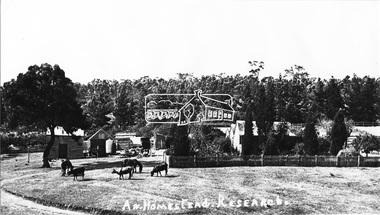 Eltham District Historical Society Inc
Photograph, "A Homestead" - Research
Source: Mrs. E.R. Reynolds, Thompson Crescent, ResearchThis photo forms part of a collection of photographs gathered by the Shire of Eltham for their centenary project book,"Pioneers and Painters: 100 years of the Shire of Eltham" by Alan Marshall (1971). The collection of over 500 images is held in partnership between Eltham District Historical Society and Yarra Plenty Regional Library (Eltham Library) and is now formally known as the 'The Shire of Eltham Pioneers Photograph Collection.' It is significant in being the first community sourced collection representing the places and people of the Shire's first one hundred years.Digital imagesepp, shire of eltham pioneers photograph collection, research (vic.)