Showing 1651 items matching "junctions"
-
 Melbourne Tram Museum
Photograph - Digital Image, Kevin O'Reilly, St Kilda looking east over St Kilda Junction, late 1925
Image from CD (Compact Diskette for use in computers) - see Reg Item 135. Image titled "St Kilda" on CD, of looking east over St Kilda Junction from. Has St Kilda tramway Jtn (St Kilda Road, Fitzroy St, Barkly St, Brighton Road, Wellington St and Punt Road in the photograph, and the "Junction Oval". Mid to late 1925 as workmen are converting the cable track in Fitzroy St and Wellington St looks or appears converted with a crossover installed near the junction. Two cable car sets visible in St Kilda Road, on in Brighton Road and a bus? Also a bus? in Fitzroy St.trams, tramways, st kilda junction, st kilda railway station, fitzroy st, brighton rd, cable trams -
 Melbourne Tram Museum
Photograph - Black & White Photograph/s, 1970's
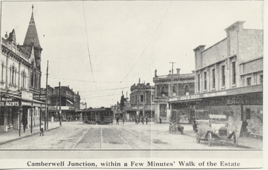
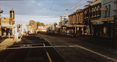
Black and white copy photograph from a Real Estate Poster of a bogie tram (HTT?) turning from Riversdale Road into Camberwell Road, c1920. Has a car (Ford Model T) parked in the street and a motorcycle. Camberwell Junction, Adair Bros, Wilson Real Estate Agents. Post office on the left hand side of the photo with the tower. Has title on photograph "Camberwell Junction, with a Few Minutes' Walk of the Estate"trams, tramways, mmtb, camberwell junction, camberwell rd -
 Kew Historical Society Inc
Photograph - Filling in the Outer Circle Railway cutting at East Kew, 1939
W.D. Vaughan (Kew's Civic Century, 1960, pp.195-6) quotes Council Minutes of 1938 and 1939 to record that: "After protracted negotiations between the Council, the Railways Department and the Tramways Board agreement was reached in June, 1938, for the filling of the railway cutting at the Harp Junction and shifting tram tracks to the High Street alignment ... The Outer Circle railway land from Princess Street to Park Crescent was purchased by the Kew Council in October, 1939, for 2,750 [pounds]. The land from Park Crescent to High Street was leased for 1 [pound] per annum. Considerable work was done in levelling the embankments to the original surface level."Important and rare photograph of the period, showing major works by Kew Council in Kew East working on a significant piece of urban infrastructure.Small, original black and white positive (photograph) showing workers and vehicles filling in the tracks of the former Outer Circle railway at East Kew. In the background is the metal bridge with brick piers, adjacent to the Harp Junction. The bridge crossed the cutting, linking the two parts of High Street. Behind the tip truck, painted on the side with the name 'Fowler Quarries' [located Keilor Road, North Essendon], one can see shops [including T.G. Garroway, Cash Grocer] in High Street. What appears to be the City of Kew Steamroller is immediately in front of the bridge. A group of passers-by watch from the bridge and from the road. Annotation in pencil on verso: "Filling in Outer Circle line at High St East Kew prior to straightening High St. (c. Feb 1930?)outer circle railway, railway cuttings, harp junction, high street -- kew east -
 Upper Yarra Museum
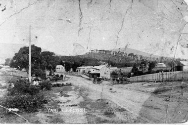
Negative Photographic Reproduction, Main St Yarra Junction
03042 Main street opposite the railway station, 1909, Yarra Junction. Upper Yarra Shire 1888-1988 Centenary collection. Black & white Negative, scanned at 600 dpiearly main street yarra junction -
 Whitehorse Historical Society Inc.
Document, Harwood, 16/08/1994
Study of Heritage value of 'Harwood', 17-21 Junction Road, Blackburn North commissioned by the City of Nunawading. Assessment covered aesthetic, historic, scientific and social values, plus photographs.heritage studies, city of nunawading, harwood, junction road blackburn north, nos. 17-21, junction road, blackburn north, no. 17-21, harris, john, redman, walter, tivendale, stanley, filshie, douglas, walling, edna -
 Ballarat Tramway Museum
Photograph - Colour Photograph/s, Carolyn Dean, c1990
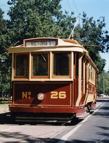
Colour Photograph of BTM No. 26 showing Victoria St. c1990 at Depot Junction, heading north. Photograph used in pamphlets such as Reg. items 294 and 300. Printed on Kodak Paper.btm, depot junction, pamphlets, tram 26 -
 Kew Historical Society Inc
Photograph, Stewart West, Junction of High Street and Cotham Road, Kew, 2001, 2001
Photograph taken by Stuart West for an exhibit comparing past and present streetscapes in KewColour photograph by Stuart West of the junction of High Street and Cotham Road, Kew. The photo was shot in 2001. It shows the Kew War Memorial, former Post Office and Court House.kew post office, cotham road (kew), high steet (kew) -
![Cotham Road [Kew]](/media/collectors/550653872162f11fb04854aa/items/6132d605e06408664db73aee/item-media/6132d631e06408664db73d5f/item-fit-380x285.jpg) Kew Historical Society Inc
Kew Historical Society IncPhotograph - Cotham Road [Kew], c.1985
Original colour positive photograph of the junction of Cotham Road and High Street in Kew, showing businesses of the period, including the Westpac Bank (left), the Greyhound Hotel, Coles and the newsagency (right)"Cotham Rd"cotham road, high street -- kew (vic.), roads -
 Melbourne Tram Museum
Photograph - Colour Print, c1985
Colour print of A class tram 259 running as a Special in High St Kew at the junction with the Mont Albert line, c1985. Has a Coles store and Maton's Pharmacy building in the background.trams, tramways, a class, kew, high st, tram 259 -
Stawell Historical Society Inc
Map, Department of Crown Lands and Survey Victoria, Allotments in the Township of Banyana. Parish of Burrum Burrum. 1946 / 1971, 1971
Richardson River. Avon River JunctionPaper Map of County of BorungReprint of the 1946 edition. Drawn and reproduced at the Department of Crown Lands and Survey Victoria 1971.survey -
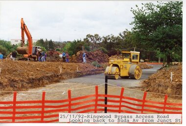 Ringwood and District Historical Society
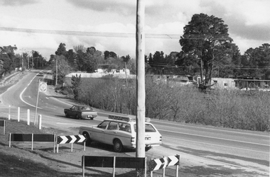
Photograph, Eastlink Ringwood Bypass Construction-Access Road looking back to Suda Ave from Junction St 25/11/1992
Colour photographWritten on back of photograph ; "25/11/92 Ringwood Bypass Access Rd - Looking back to Suda Ave from Junction St" -
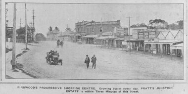 Ringwood and District Historical Society
Photograph, Maroondah Highway Central, Ringwood. Ringwood Shopping Centre, Whitehorse Rd- 1924
Black and white photograph (3 copies) Typed below one photograph: "Ringwood Shopping Centre, Whitehorse Rd. - 1924". Typed below other copies: "Ringwood's progressive shopping centre. Growing busier every day. Pratt's Junction Estate is within Three Minutes of this Street". Typed on back of one copy: "Copied from a circular by F.V. Parker 24/11/23 advertising Pratts Junction Estate. 86 lots. Oliver St. Georges Rd. & Junction St., between Mullum Creek & Whitehorse Rd. £3 deposit and 1£ per month." -
 Federation University Historical Collection
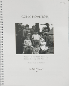
Book, Anne Pitman, Going Home to RJ: Rokewood Junction Stories, Local History and Families: More than a Memoir, 2023
Beverley Chatham ( daughter of Arthur Chatham) suggested that Commerlghip refers to Watering holes and underground springs found in the Little Woady Yallok and Mt Misery Creeks. Rokewood Junction was proclaimed a township in 1885, originally known as a gold-mining township called Paddy's Gully Diggings.Ringbound publication of 212 pagesnon-fictionBeverley Chatham ( daughter of Arthur Chatham) suggested that Commerlghip refers to Watering holes and underground springs found in the Little Woady Yallok and Mt Misery Creeks. Rokewood Junction was proclaimed a township in 1885, originally known as a gold-mining township called Paddy's Gully Diggings. rokewood, rokewood junction, chatham, kurus-a-ruc, henry pitman, elizabeth pitman, william henry pitman, rokewood junction state school, commeralghip, paddy's gully bridge, illabrook, conereyalk, woady yalloak creek, mt misery creek, paddy's gully diggings., dereel, pitfield, wadawurrung, william rutland, squatters, aborigines, aboriginal, charlotte walsh, maurice walsh, julie pitman, ben liston, sheep and wool, george hawkins, natthew wakeling, christopher moody, mt misery goldfield, john bower, mary bower, hyslop's hotel, cumberland store, jane hyslop, edward collyer, jospeh gladstone, lucas's bakery, henry batty, william young, ellen rigby, chinese, joseph anguey, eliza anguey, murder of thomas ulick burke, william achultze, william schiltze, nicholas grenfell, tomas bramley murder, emily malhoff, drowning, ah lin, eliza richards, luisa bupell, eleanor holmes, rachel holmes, joseph holloway, noah holloway, thomas faulkner, robert eli hearn, george todhunter briggs, john robinson fairweather, rokewood common, edward bussell, louisa bussell, irving rachinger, john chatham, doris chatham, peter chatham, jack chatham, imogen chatham, domenico rizzoli, mary rizzoli, rokewood junction railway line, illabrook football and netball club, cape clear, red cross, keith annear, fire brigade, rokewood junction post office, len aarons, dereel pre-emptive right, rokewood junction avenue of honour, arthur chatham -
 Halls Gap & Grampians Historical Society
Photograph - B/W, C 1950s (?)
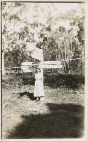
The woman is Mrs. Ron Groves, formerly Dulcie Stevenson, Cheltenham.The photo shows a woman standing in front of road signs at a road junction. The visible signs read "17 Stawell" and "163 Melbourne" to the left and "Halls Gap 1" and "Dunkeld 49" to the right.people, tourists -
 Kiewa Valley Historical Society
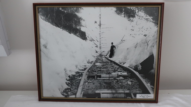
Photos - Junction Dam Spillway, Kiewa Hydro Electric Scheme
2 black and white small photos titled - A. 'Bogong Village, Kiewa Hydro Electric Project' and B. 'Junction Dam & Spillway, Lake Guy, Bogong, Kiewa Hydro Electric Project' -
 Melbourne Tram Museum
Photograph - Black & White Photograph/s, LWR, c1920
Copy photographs . Photograph, Black and White of MMTB tram F46 about to pass under the railway bridge at Caulfield. Photo is very poor copy. Has the Caulfield loop junction in the foreground.In ink on the rear: " Melbourne Probably F46, under railway bridge at Caulfield, About 1920." Has KSK number LWR5 and ADV322trams, tramways, f class, pmtt, bridges, caulfield, tram 46 -
 Melbourne Tram Museum
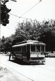
Photograph - Black and White photograph, 1967
Black and White photograph of W5 790, Route 56, West Coburg about to leave the junction at Flemington Road and run through Royal Park. The tram shelter and cross over are in the view.On rear in ink "Melbourne Vic (1967)"trams, tramways, w5 class, royal park, flemington road, route 56, shelters, tram 790 -
Malmsbury Historical Society
Photograph (Item), The Mansions Malmsbury + 2 M/Print, Malmsbury ca1970
People - "Young, Betty" Buildings - "The Mansions,Junction Holtel" -
 Kiewa Valley Historical Society
Postcard - Junction Dam - Circa 1950, Circa 1950
This postcard was produced in the 1950's for the tourist trade in the Kiewa Valley and Alpine region. It encompasses the period when the State of Victoria was pressured by the ever increasing demand by industry and its population for electricity supplies. Hydro electricity was seen as an untapped natural resource to quench this demand. The Victorian Alps and the rivers flowing into its valleys was ideal for the construction of the Kiewa Hydro Electricity Scheme. The late 1940's saw the development of this scheme and the changing of sections of alpine landscape is covered by this and other postcards/pictures (tourists, construction workers, and established rural populations). This period in time was before the established wildlife and forest/nature groups became political activist who changed legislative acts to protect the environment.This rural region (Kiewa Valley/alpine plains) was at most only significant to a smaller group of winter sports, summer hikers/horse riders and rural farmers/graziers. The numbers of tourists and the increase in the local resident population was boosted by the construction of the Hydro Electricity Scheme. This influx to the regional population resulted in a corresponding diversity in services and brought about an environment that responded to a growing level of tourists and thereby permitting this industry to grow more rapidly than it would have naturally. This postcard details an attraction to the "cleaner" method of providing electricity. This postcard was purchased in 1950 by a surveyor at Landford's Gap.This black and white photograph on a Valentine's postcard is from a V2 Argus photograph. It is on a 200g/m paper density one side gloss only/. See 0480 (A) -(L) for other photos of similar postcards."JUNCTION DAM & SPILLWAY, LAKE GUY, BOGONG, KIEWA HYDRO-ELECTRIC PROJECT" "V5" on the flip side" VALENTINE'S POST CARD " "A GENUINE PHOTOGRAPH"kiewa valley tourism, victorian alps, alternate energy supplies, alpine population growth, junction dam, secv -
 Ringwood and District Historical Society
Photograph, Junction of Warrandyte Road, Old Warrandyte Road and Tortice Drive, North Ringwood looking south 1981
Written on back of photograph, "19/6/81. The junction of Warrandyte Road, Old Warrandyte Road and Tortice Drive, North Ringwood looking south." -
 Kiewa Valley Historical Society
Set of 6 framed photographs - Kiewa Hydro Electric Scheme
Official photo of KHES constructed by SECVOfficial photo of KHES in the Kiewa Valley1. No. 1 Pipeline - from Anchor 1 to Anchor 5. August 1955 2. Junction Dam - General View from Downstream - May 1943 3. No. 3 Power Station - Clover Flat Camp - February 1951 4. Clover Dam - October 1954 5. View from Downstream of Junction Dam - July 1943 6. Upper Kiewa Valley Road 3 to 4 Mile - Mt Arthur in Background - July 1954 khes, secv -
 Ballarat Tramway Museum
Photograph - Black & White Photograph/s - set of 4, Richard Gilbert, Sept. 1975
Series of four Black and white photographs of tram 26 being operated following maintenance in Wendouree Parade. The tramcar record sheets note that the car was lifted 15-3-1975 and lowered 27-7-1975 and tested on the same day. Seems to have re-entered service on 28/9/1975. .1 - At Gardens Loop. .2 - At depot Junction .3 - At St Aidans Drive with Andrew Hall standing at the rear of the tram. .4 - at depot Junction. trams, tramways, btps, gardens loop, maintenance, wendouree parade, depot junction, st aidans drive, tram 26 -
 Ballarat Tramway Museum
Photograph - Colour Photograph/s - set of 6, Carolyn Dean, 19/10/2003 12:00:00 AM
Set of six photographs taken by Carolyn Dean of the BTM services - AGM 2003 on 19.10.2003. 2600.1 - No. 28 arriving at Depot Junction. 2600.2 - No. 28 leaving Depot Junction with No. 27 waiting to cross Wendouree Parade 2660.3 - No. 27 crossing Wendouree Parade on Members Special 2600.4 - No. 27 at Carlton St. terminus 2660.5 - Nos. 661, 27 and 45 on Depot Fan 2660.4 - Tower Truck outside Depot on No. 1 Road, with No. 45 in background.On rear of each print in blue biro "19.10.03" / "Photo by Carolyn Dean".btm, depot, wendouree parade, tram 28, tram 27, tram 45, tram 661 -
 Ballarat Tramway Museum
Ephemera - Membership Card/s, Ballarat Tramway Museum (BTM), 2015
Colour photograph printed onto white card as a BTM Membership card for 2015 - 2016. Photo of trams 27 and 671 at depot junction Jan. 2015 following the reconstruction of Wendouree Parade. Has the words "Ballarat Tramway Museum" in green block printing on the upper edge of the card. On rear along bottom edge, has words "Trams 27 & 671 at Depot Junction 2015. Photo P. Winspur" Two copies held. No label on rear.trams, tramways, membership cards, depot junction, btm, wendouree parade, road works -
 Whitehorse Historical Society Inc.
Photograph - B/W Photograph, Ploughing at 17 - 21 Junction Road, Blackburn
Black and white photo of ploughing on 'Harwood' a home at 17 - 21 Junction Road Blackburn. Home is believed to be wrongly described as the Slater home. See ND1270 at G-H 53. 2 copies.ploughing, harwood, junction road, blackburn north, nos.17 - 21 -
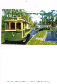
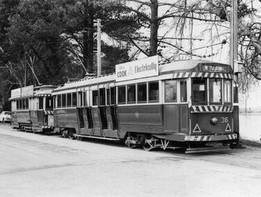 Ballarat Tramway Museum
Photograph - Black & White Photograph/s, Leon Marshall-Wood, Aug. 1964
Yields information about the Ballarat's tramcars in the mid 1960's before the white strip was extended under the dash canopy lighting.Black and white photograph of Ballarat No. 36 and a single truck car at the SEC's Depot Junction. No. 36 has the destination of Mt Pleasant, and a "Cook with Electricity" roof advertisement. A single truck stands behind.On the Rear in ink "Wendouree Pde, Ballarat 8/64" and a "L. Marshall-Wood Photograph" stamp on the rear.tramways, trams, wendouree parade, secv, depot junction, tram 36 -
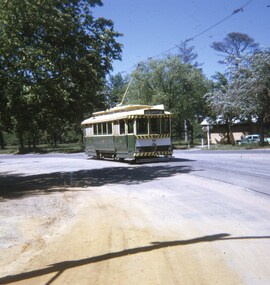 Ballarat Tramway Museum
Slide - 27 mm sq slide/s, Andrew Howlett, Tram 28 in Wendouree Parade, Mar. 1969
Yields information about the services in Wendouree Parade near the future BTPS/BTM depot junction.Colour slide, Kodak white cardboard mount, developed March 1969, of No. 28 (Mt Pleasant) in Wendouree Parade approaching what is now the BTM Depot Junction. Has the toilet block in the background.ballarat, tramways, trams, wendouree parade, depot junction, tram 28 -
 Kew Historical Society Inc
Photograph, Stewart West, High Street, Kew, 2001, 2001
High Street, Kew. View west towards Kew Junction. One of a pair of photographs prepared by Stuart West comparing the vista in c. 1890 and 2001. This photograph dates from the later date.Nilhigh street (kew) -
 Kew Historical Society Inc
Photograph - Street Works, Studley Park Road, March 1934
Studley Park Road, like most streets in Kew, was originally a dirt road. Street works during the Great Depression included bituminising major roads in the district. This photograph of Council works originated in the City of Kew Engineers Department as a record of works undertaken. It was given to the collection by a Mrs Fisher in 1998.Well provenanced photograph of Council-funded public works in Kew during the Great Depression. Original sepia monochrome positive of Council workers standing on and beside a dray in Studley Park Road, Kew while resurfacing of the street was taking place. The Kew Junction is just visible behind the men.Typed reverse: "B4 / Kew C.C. / Spreading premixed material on Studley Park Road with drag spreader, view from rear of machine, March 1934"roadworks -- kew (vic.), street works -- kew (vic.), public works kew (vic.), studley park road -- kew (vic.), city of kew -- engineers department, city of kew -- public works -- great depression -- 1930s -
 Bendigo Historical Society Inc.
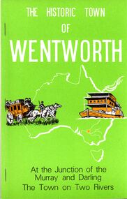
Book - STRAUCH COLLECTION: THE HISTORIC TOWN OF WENTWORTH
BHS CollectionThe Historic Town Of Wentworth, at the junction of the Murray and Darling, the town on two rivers.History of Wentworth Sunraysia's oldest town seventh edition December 1984, soft cover 88 pages with black and white photographs.australia, history, wentworth, australia-history-nsw-wentworth