Showing 1133 items matching "kew east"
-
 Kew Historical Society Inc
Photograph - Flooding of the Yarra Valley at Kew East, 1974
... Flooding of the Yarra Valley at Kew East... of the Yarra bordering Kew and Kew East in the north and west... land at East Kew under floodwater on 16 May 1974. The vantage... bordering Kew and Kew East in the north and west of the municipality ...Flooding of the Yarra Valley, including that section of the Yarra bordering Kew and Kew East in the north and west of the municipality, was a regular occurrence. Extreme flood events of the Yarra River are recorded to have occurred in 1891, 1901, 1916, 1923 and 1934. The Municipality of Kew's response to these floods was to enact planning decisions restricting residential development in flood prone areas following the floods of 1916, 1921 and 1934. While floods continued after the development of the Upper Yarra Reservoir (construction 1948-57), the regularity and extent of these inundations diminished. During the nineteenth century, the land abutting the south side of the Yarra in Kew was devoted to dairy farming. In the twentieth century, before and after the construction of the Eastern Freeway, much of this low-lying area was used as golf courses and public parks.Late example of the capacity of the Yarra Valley at Kew to flood, even though drainage works and the Upper Yarra Reservoir had reduced their regularity.Original black and white print photograph of the low-lying land at East Kew under floodwater on 16 May 1974. The vantage point of the photographer is Lister Street. Flooding was caused by overflowing water in Glass' Creek and the River Yarra. Annotation verso: "Lister Street looking north / Flood level / 16 May 1974 11.30am / R.L. 46.04"hays paddock, floods, yarra river, glass' creek, lister street -
 Kew Historical Society Inc
Photograph - Flooding of the Yarra Valley at Kew East, 1974
... Flooding of the Yarra Valley at Kew East... of the Yarra bordering Kew and Kew East in the north and west... land at East Kew under floodwater on 16 May 1974. The vantage... bordering Kew and Kew East in the north and west of the municipality ...Flooding of the Yarra Valley, including that section of the Yarra bordering Kew and Kew East in the north and west of the municipality, was a regular occurrence. Extreme flood events of the Yarra River are recorded to have occurred in 1891, 1901, 1916, 1923 and 1934. The Municipality of Kew's response to these floods was to enact planning decisions restricting residential development in flood prone areas following the floods of 1916, 1921 and 1934. While floods continued after the development of the Upper Yarra Reservoir (construction 1948-57), the regularity and extent of these inundations diminished. During the nineteenth century, the land abutting the south side of the Yarra in Kew was devoted to dairy farming. In the twentieth century, before and after the construction of the Eastern Freeway, much of this low-lying area was used as golf courses and public parks.Late example of the capacity of the Yarra Valley at Kew to flood, even though drainage works and the Upper Yarra Reservoir had reduced their regularity.Original black and white print photograph of the low-lying land at East Kew under floodwater on 16 May 1974. The vantage point of the photographer is Lister Street. Flooding was caused by overflowing water in Glass' Creek and the River Yarra. Annotation verso: "Lister St looking same as No.3 / 16 May 1974 11.30"floods, yarra river, glass' creek, lister street -
 Kew Historical Society Inc
Photograph - Yarra Valley Floods: Kew East, 1916
... Yarra Valley Floods: Kew East... of the Yarra bordering Kew and Kew East in the north and west...Flooding of the Yarra Valley at East Kew in 1916. The view... bordering Kew and Kew East in the north and west of the municipality ...Flooding of the Yarra Valley, including that section of the Yarra bordering Kew and Kew East in the north and west of the municipality, was a regular occurrence. Extreme flood events of the Yarra River are recorded to have occurred in 1891, 1901, 1916, 1923 and 1934. The Municipality of Kew's response to these floods was to enact planning decisions restricting residential development in flood prone areas following the floods of 1916, 1921 and 1934. While floods continued after the development of the Upper Yarra Reservoir (construction 1948-57), the regularity and extent of these inundations diminished. During the nineteenth century, the land abutting the south side of the Yarra in Kew was devoted to dairy farming. In the twentieth century, before and after the construction of the Eastern Freeway, much of this low-lying area was used as golf courses and public parks.One of a collection of photographs of flooding in the Kew section of the Yarra Valley which are in important research resource for the location and extent of flooding in the first half of the twentieth century. Flooding of the Yarra Valley at East Kew in 1916. The view is taken from the intersection of Kilby Road with what is believed to be Birdwood Street, looking across the flood waters to Ivanhoe. The extensive flooded area shown in the photograph would have included the Kew Golf Club. Verso: "Floods along Kilby Road / near Birdwood St? & Kilby Road / 1917? / 87yarra river, yarra valley, floods -- kew, kilby road -- kew (vic.), kew golf club -
 Kew Historical Society Inc
Photograph - Flooding of the Yarra Valley at Kew East, 1974
... Flooding of the Yarra Valley at Kew East... of the Yarra bordering Kew and Kew East in the north and west... land at East Kew under floodwater on 16 May 1974. The vantage... bordering Kew and Kew East in the north and west of the municipality ...Flooding of the Yarra Valley, including that section of the Yarra bordering Kew and Kew East in the north and west of the municipality, was a regular occurrence. Extreme flood events of the Yarra River are recorded to have occurred in 1891, 1901, 1916, 1923 and 1934. The Municipality of Kew's response to these floods was to enact planning decisions restricting residential development in flood prone areas following the floods of 1916, 1921 and 1934. While floods continued after the development of the Upper Yarra Reservoir (construction 1948-57), the regularity and extent of these inundations diminished. During the nineteenth century, the land abutting the south side of the Yarra in Kew was devoted to dairy farming. In the twentieth century, before and after the construction of the Eastern Freeway, much of this low-lying area was used as golf courses and public parks.Late example of the capacity of the Yarra Valley at Kew to flood, even though drainage works and the Upper Yarra Reservoir had reduced their regularity.Original black and white print photograph of the low-lying land at East Kew under floodwater on 16 May 1974. The vantage point of the photographer is Lister Street. In the photo, the fences of the Kilby Farm can be seen. Flooding was caused by overflowing water in Glass' Creek and the River Yarra. Annotation verso: "Hay's Paddock op No.30 Lister Street / 16 May 1974 11.50am / R.L. 46.04"hays paddock, floods, yarra river, glass' creek, lister street -
 Kew Historical Society Inc
Archive (Sub-series) - Subject File, Kew Historical Society, Hays Paddock (Kew East), 1958
... Hays Paddock (Kew East)...hays paddock - kew east (vic)... sources. kew historical society - archives hays paddock - kew east ...Various partiesReference, Research, InformationSecondary Values (KHS Imposed Order)Subject file containing many newspaper/magazine articles/clippings (1979-2016), some published by the City of Boroondara, and maps, summaries of reports (KNews, 1980) and proposals to create an ‘integrated playground’ at Hays Paddock.kew historical society - archives, hays paddock - kew east (vic), parks and gardens - kew east (vic)kew historical society - archives, hays paddock - kew east (vic), parks and gardens - kew east (vic) -
 Kew Historical Society Inc
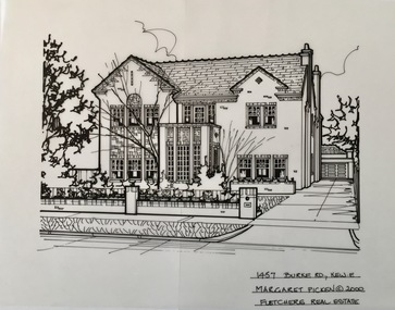
Drawing - Property Illustration, Margaret Picken, 1457 Burke Road, Kew East, 2000
... 1457 Burke Road, Kew East...property illustrations — buildings — kew east (vic.)... — buildings — kew (vic.) property illustrations — buildings — kew east ...After training as a Cartographic Draftsman within the mining industry, I worked as a property illustrator for real estate firms in the eastern suburbs of Melbourne for 23 years from 1983. I initially photographed houses with a Polaroid camera and made a 'thumbnail' sketch while there. The photos were used to scale off a sketch in pencil and then that sketch was overlaid with drafting film and the 'pen and ink' completed. The pens I used were the Rotring ‘Rapidigraph’ drafting pens. The ink was also made by Rotring (German).The film was ‘Rapidraw’, polyester drafting film, double matte. It takes a very fine line and doesn’t bleed. As well as house sketches, there were often floor plans and site plans ordered. Aerial sketches were ordered when the property needed an overall view. (Margaret Picken, 2020)This drawing is one of a series created by Margaret Picken for real estate agents in Melbourne between 1983 and 2006. Each work is signed and dated by the artist.Gift of Margaret Picken, 2020'Hastings' was built in the English Revival style in 1930. The pen and ink drawing on drafting film was created by Margaret Picken in 2000.1467 BURKE RD., KEWE. / MARGARET PICKEN (c) 2000 / FLETCHERS REAL ESTATEartist -- margaret picken 1950-, property illustrations — buildings — kew (vic.), property illustrations — buildings — kew east (vic.), 1457 burke road -- kew east (vic.) -
![Harp Junction [East Kew]](/media/collectors/550653872162f11fb04854aa/items/58cf089ed0ce9809d8713015/item-media/58cf59f9d0ce603314508da0/item-fit-380x285.jpg) Kew Historical Society Inc
Kew Historical Society IncPhotograph, Harp Junction [East Kew], 1910-1930
... Harp Junction [East Kew]...strathalbyn street (kew east)...The Harp Junction, East Kew... street (kew) strathalbyn street (kew east) harp of erin hotel ...The Harp Junction, East KewAnnotations on reverse "KH-73. View from Junction of High St (then Bulleen Rd.) & Strathalbyn St. Kew. Looking toward Boroondara Cemetery. Wall in picture is side of bridge over Outer Circle Railway. Trams later cut across this curve."high street (kew), strathalbyn street (kew east), harp of erin hotel (kew) -
 Kew Historical Society Inc
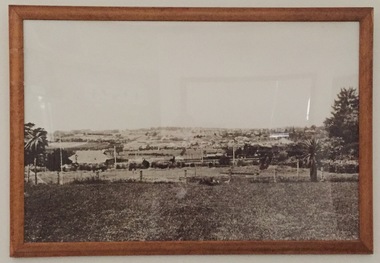
Photograph - East Kew, 1920-1930
... East Kew...east kew (vic.)...Very large framed photograph of East Kew looking towards... farmland - kew (vic.) east kew (vic.) Very large framed photograph ...Very large framed photograph of East Kew looking towards Balwyn. farmland - kew (vic.), east kew (vic.) -
 Kew Historical Society Inc
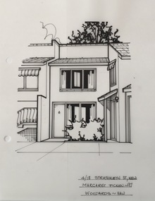
Drawing - Property Illustration, Margaret Picken, 4/18 Strathalbyn Street, Kew East, 1997
... 4/18 Strathalbyn Street, Kew East... Strathalbyn Street, Kew East by Margaret Picken.... of 4/18 Strathalbyn Street, Kew East by Margaret Picken. 4/18 ...After training as a Cartographic Draftsman within the mining industry, I worked as a property illustrator for real estate firms in the eastern suburbs of Melbourne for 22 years from 1983. I initially photographed houses with a Polaroid camera and made a 'thumbnail' sketch while there. The photos were used to scale off a sketch in pencil and then that sketch was overlaid with drafting film and the 'pen and ink' completed. The pens I used were the Rotring ‘Rapidigraph’ drafting pens. The ink was also made by Rotring (German).The film was ‘Rapidraw’, polyester drafting film, double matte. It takes a very fine line and doesn’t bleed. As well as house sketches, there were often floor plans and site plans ordered. Aerial sketches were ordered when the property needed an overall view. (Margaret Picken, 2020)This drawing is one of a series created by Margaret Picken for a number of real estate agents in Melbourne between 1983 and 2005. Each work is signed and dated by the artist.Gift of Margaret Picken, 2020Pen and ink architectural drawing on drafting film of 4/18 Strathalbyn Street, Kew East by Margaret Picken.4/18 STRATHALBYN ST., KEW / MARGARET PICKEN ~97 / WOODARDS ~ HAWartist -- margaret picken 1950-, architectural drawings -- houses -- kew (vic.), 4/18 strathalbyn street - kew (vic) -
 Ballarat Heritage Services
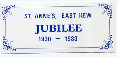
Photograph, St Anne's East Kew Jibilee Sticker, 1980, 1980
... St Anne's East Kew Jibilee Sticker, 1980...St Anne's East Kew...St Anne's East Kew opened in 1930....Blue and white sticker of St Anne's Primary School in East...St Anne's East Kew opened in 1930. Sticker St Anne's East ...St Anne's East Kew opened in 1930.Blue and white sticker of St Anne's Primary School in East Kew. sticker, st anne's east kew, education -
 Ballarat Heritage Services
Photograph - Digital photographs, L.J. Gervasoni, St Anne's East Kew, c2015
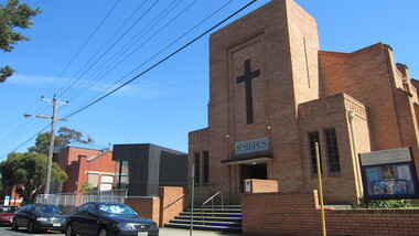
... St Anne's East Kew...east kew... is in Beresford Street, East Kew.... Office goldfields kew east kew st anne's catholic church St ...St Anne's Primary School and Catholic Church is in Beresford Street, East Kew.kew, east kew, st anne's, catholic, church, st anne's east kew, st anne's catholic church -
 Kew Historical Society Inc
Photograph - Road works in East Kew, 1977
... Road works in East Kew...kew east... in East Kew north of McCubbin Street, near Hays Paddock.... street works kew east Reverse: "JULY '77 / SHOWING AREA NORTH ...One of a series of photographs donated by the City Engineer of the former City of Kew, relating to road works. The photos variably include council workers, signage and equipment.One of a series of photographs of core local government services as practised by the City of Kew. The photographs are an accurate record of street works of the period. Original black and white photographic positive of roadworks in East Kew north of McCubbin Street, near Hays Paddock.Reverse: "JULY '77 / SHOWING AREA NORTH OF MCCUBBIN / STREET STRIPPED OF TOPSOIL"city of kew, local government -- city of kew, road works, street works, kew east -
 Kew Historical Society Inc
Photograph, City of Kew, Hays Paddock, Kew East, c.1980
... Hays Paddock, Kew East...hays paddock - kew east (vic)... paddock - kew east (vic) kew (vic) - history kew (vic) - public ...One of a series of photos created for an exhibition by the City of Kew of notable locations. The photos represent a snapshot in time.Enlarged photograph mounted on board, donated to the Kew Historical Society by the City of Kew on 10 April 1991.hays paddock - kew east (vic), kew (vic) - history, kew (vic) - public parks, kew (vic) - farming -
 Kew Historical Society Inc
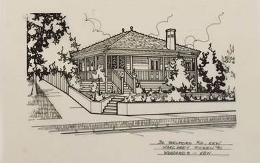
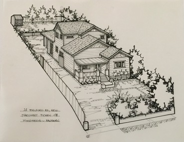
Drawing - Property Illustration, Margaret Picken, 30 Belford Road, Kew East, 1990
... 30 Belford Road, Kew East....30 belford road - kew east (vic).... east (vic). 30 BELFORD RD., KEW / MARGARET PICKEN '90 ...After training as a Cartographic Draftsman within the mining industry, I worked as a property illustrator for real estate firms in the eastern suburbs of Melbourne for 23 years from 1983. I initially photographed houses with a Polaroid camera and made a 'thumbnail' sketch while there. The photos were used to scale off a sketch in pencil and then that sketch was overlaid with drafting film and the 'pen and ink' completed. The pens I used were the Rotring ‘Rapidigraph’ drafting pens. The ink was also made by Rotring (German).The film was ‘Rapidraw’, polyester drafting film, double matte. It takes a very fine line and doesn’t bleed. As well as house sketches, there were often floor plans and site plans ordered. Aerial sketches were ordered when the property needed an overall view. (Margaret Picken, 2020)This drawing is one of a series created by Margaret Picken for a range of real estate agents in Melbourne between c.1983 and c.2005. Each work is signed and dated by the artist.Gift of Margaret Picken, 2020Pen and ink drawing on drafting film of 30 Belford Road, Kew by Margaret Picken.30 BELFORD RD., KEW / MARGARET PICKEN '90 / WOODARDS ~ KEWartist -- margaret picken 1950-, architectural drawings -- houses -- kew (vic.), 30 belford road - kew east (vic). -
 Kew Historical Society Inc
Drawing - Property Illustration, Margaret Picken, 28 Belford Road, Kew East, 1998
... 28 Belford Road, Kew East....28 belford road - kew east (vic).... east (vic). 28 BELFORD RD., KEW / MARGARET PICKEN '98/ WOODARDS ...After training as a Cartographic Draftsman within the mining industry, I worked as a property illustrator for real estate firms in the eastern suburbs of Melbourne for 23 years from 1983. I initially photographed houses with a Polaroid camera and made a 'thumbnail' sketch while there. The photos were used to scale off a sketch in pencil and then that sketch was overlaid with drafting film and the 'pen and ink' completed. The pens I used were the Rotring ‘Rapidigraph’ drafting pens. The ink was also made by Rotring (German).The film was ‘Rapidraw’, polyester drafting film, double matte. It takes a very fine line and doesn’t bleed. As well as house sketches, there were often floor plans and site plans ordered. Aerial sketches were ordered when the property needed an overall view. (Margaret Picken, 2020)This drawing is one of a series created by Margaret Picken for a range of real estate agents in Melbourne between c.1983 and c.2005. Each work is signed and dated by the artist.Gift of Margaret Picken, 2020Pen and ink drawing on drafting film of 28 Belford Road, Kew by Margaret Picken.28 BELFORD RD., KEW / MARGARET PICKEN '98/ WOODARDS ~ HAWTHORNartist -- margaret picken 1950-, architectural drawings -- houses -- kew (vic.), 28 belford road - kew east (vic). -
 Kew Historical Society Inc
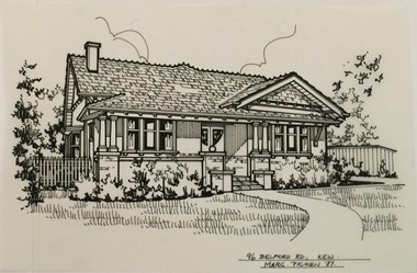
Drawing - Property Illustration, Margaret Picken, 96 Belford Road, Kew East, 1987
... 96 Belford Road, Kew East....96 belford road - kew east (vic).... east (vic). 96 BELFORD RD., KEW / MARG PICKEN '87 Pen and ink ...After training as a Cartographic Draftsman within the mining industry, I worked as a property illustrator for real estate firms in the eastern suburbs of Melbourne for 23 years from 1983. I initially photographed houses with a Polaroid camera and made a 'thumbnail' sketch while there. The photos were used to scale off a sketch in pencil and then that sketch was overlaid with drafting film and the 'pen and ink' completed. The pens I used were the Rotring ‘Rapidigraph’ drafting pens. The ink was also made by Rotring (German).The film was ‘Rapidraw’, polyester drafting film, double matte. It takes a very fine line and doesn’t bleed. As well as house sketches, there were often floor plans and site plans ordered. Aerial sketches were ordered when the property needed an overall view. (Margaret Picken, 2020)This drawing is one of a series created by Margaret Picken for a range of real estate agents in Melbourne between c.1983 and c.2003. Each work is signed and dated by the artist.Gift of Margaret Picken, 2020Pen and ink drawing on drafting film of 96 Belford Road, Kew by Margaret Picken.96 BELFORD RD., KEW / MARG PICKEN '87artist -- margaret picken 1950-, architectural drawings -- houses -- kew (vic.), 96 belford road - kew east (vic). -
 Kew Historical Society Inc
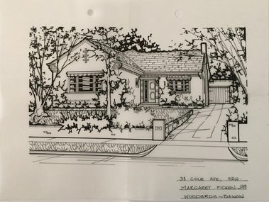
Drawing - Property Illustration, Margaret Picken, 38 Cole Avenue, Kew East, 1999
... 38 Cole Avenue, Kew East....38 cole avenue - kew east (vic)....- architectural drawings -- houses -- kew (vic.) 38 cole avenue - kew east ...After training as a Cartographic Draftsman within the mining industry, I worked as a property illustrator for real estate firms in the eastern suburbs of Melbourne for 23 years from 1983. I initially photographed houses with a Polaroid camera and made a 'thumbnail' sketch while there. The photos were used to scale off a sketch in pencil and then that sketch was overlaid with drafting film and the 'pen and ink' completed. The pens I used were the Rotring ‘Rapidigraph’ drafting pens. The ink was also made by Rotring (German).The film was ‘Rapidraw’, polyester drafting film, double matte. It takes a very fine line and doesn’t bleed. As well as house sketches, there were often floor plans and site plans ordered. Aerial sketches were ordered when the property needed an overall view. (Margaret Picken, 2020)This drawing is one of a series created by Margaret Picken for a range of real estate agents in Melbourne between c.1983 and c.2005. Each work is signed and dated by the artist.Gift of Margaret Picken, 2020Pen and ink architectural drawing on drafting film of 38 Cole Avenue, Kew by Margaret Picken.38 COLE AVE., KEW / MARGARET PICKEN ~99 / WOODARDS ~ BALWYNartist -- margaret picken 1950-, architectural drawings -- houses -- kew (vic.), 38 cole avenue - kew east (vic). -
 Kew Historical Society Inc
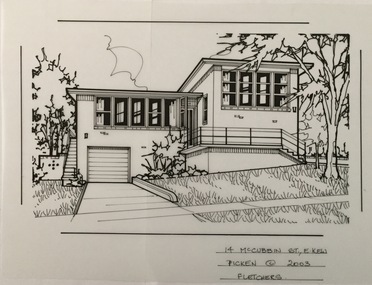
Drawing - Property Illustration, Margaret Picken, 14 McCubbin Street, Kew East, 2003
... 14 McCubbin Street, Kew East...14 mccubbin street - kew east (vic).... east (vic). 14 McCUBBIN ST., E. KEW / PICKEN © 2003 / FLETCHERS ...After training as a Cartographic Draftsman within the mining industry, I worked as a property illustrator for real estate firms in the eastern suburbs of Melbourne for 23 years from 1983. I initially photographed houses with a Polaroid camera and made a 'thumbnail' sketch while there. The photos were used to scale off a sketch in pencil and then that sketch was overlaid with drafting film and the 'pen and ink' completed. The pens I used were the Rotring ‘Rapidigraph’ drafting pens. The ink was also made by Rotring (German).The film was ‘Rapidraw’, polyester drafting film, double matte. It takes a very fine line and doesn’t bleed. As well as house sketches, there were often floor plans and site plans ordered. Aerial sketches were ordered when the property needed an overall view. (Margaret Picken, 2020)This drawing is one of a series created by Margaret Picken for a number of real estate agents in Melbourne between 1983 and 2005. Each work is signed and dated by the artist.Gift of Margaret Picken, 2020Pen and ink architectural drawing on drafting film of14 McCubbin Street, Kew by Margaret Picken.14 McCUBBIN ST., E. KEW / PICKEN © 2003 / FLETCHERSartist -- margaret picken 1950-, architectural drawings -- houses -- kew (vic.), 14 mccubbin street - kew east (vic). -
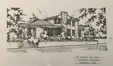 Kew Historical Society Inc
Drawing - Property Illustration, Margaret Picken, 33 Mathers Avenue, Kew East, 1992
... 33 Mathers Avenue, Kew East...33 mathers avenue - kew east (vic).... east (vic). 33 MATHERS AVE., KEW / MARGARET PICKEN ~92 ...After training as a Cartographic Draftsman within the mining industry, I worked as a property illustrator for real estate firms in the eastern suburbs of Melbourne for 23 years from 1983. I initially photographed houses with a Polaroid camera and made a 'thumbnail' sketch while there. The photos were used to scale off a sketch in pencil and then that sketch was overlaid with drafting film and the 'pen and ink' completed. The pens I used were the Rotring ‘Rapidigraph’ drafting pens. The ink was also made by Rotring (German).The film was ‘Rapidraw’, polyester drafting film, double matte. It takes a very fine line and doesn’t bleed. As well as house sketches, there were often floor plans and site plans ordered. Aerial sketches were ordered when the property needed an overall view. (Margaret Picken, 2020)This drawing is one of a series created by Margaret Picken for a number of real estate agents in Melbourne between 1983 and 2005. Each work is signed and dated by the artist.Gift of Margaret Picken, 2020Pen and ink architectural drawing on drafting film of 33 Mathers Avenue, Kew by Margaret Picken.33 MATHERS AVE., KEW / MARGARET PICKEN ~92 / WOODARDS ~ KEWartist -- margaret picken 1950-, architectural drawings -- houses -- kew (vic.), 33 mathers avenue - kew east (vic). -
 Kew Historical Society Inc
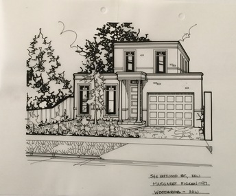
Drawing - Property Illustration, Margaret Picken, 54A Hartwood Street, Kew East, 1997
... 54A Hartwood Street, Kew East...54a hartwood street - kew east (vic)... east (vic) 54A HARTWOOD ST., KEW / MARGARET PICKEN ~97 ...After training as a Cartographic Draftsman within the mining industry, I worked as a property illustrator for real estate firms in the eastern suburbs of Melbourne for 23 years from 1983. I initially photographed houses with a Polaroid camera and made a 'thumbnail' sketch while there. The photos were used to scale off a sketch in pencil and then that sketch was overlaid with drafting film and the 'pen and ink' completed. The pens I used were the Rotring ‘Rapidigraph’ drafting pens. The ink was also made by Rotring (German).The film was ‘Rapidraw’, polyester drafting film, double matte. It takes a very fine line and doesn’t bleed. As well as house sketches, there were often floor plans and site plans ordered. Aerial sketches were ordered when the property needed an overall view. (Margaret Picken, 2020)This drawing is one of a series created by Margaret Picken for a number of real estate agents in Melbourne between 1983 and 2005. Each work is signed and dated by the artist.Gift of Margaret Picken, 2020Pen and ink architectural drawing on drafting film of 54A Hartwood Street, Kew by Margaret Picken.54A HARTWOOD ST., KEW / MARGARET PICKEN ~97 / WOODARDS ~ HAWartist -- margaret picken 1950-, architectural drawings -- houses -- kew (vic.), 54a hartwood street - kew east (vic) -
 Kew Historical Society Inc
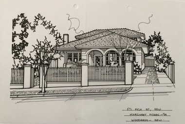
Drawing - Property Illustration, Margaret Picken, 571 High Street, Kew East, 1994
... 571 High Street, Kew East...571 high street - kew east (vic).... east (vic). 571 HIGH ST., KEW / MARGARET PICKEN ~94 / WOODARDS ...After training as a Cartographic Draftsman within the mining industry, I worked as a property illustrator for real estate firms in the eastern suburbs of Melbourne for 23 years from 1983. I initially photographed houses with a Polaroid camera and made a 'thumbnail' sketch while there. The photos were used to scale off a sketch in pencil and then that sketch was overlaid with drafting film and the 'pen and ink' completed. The pens I used were the Rotring ‘Rapidigraph’ drafting pens. The ink was also made by Rotring (German).The film was ‘Rapidraw’, polyester drafting film, double matte. It takes a very fine line and doesn’t bleed. As well as house sketches, there were often floor plans and site plans ordered. Aerial sketches were ordered when the property needed an overall view. (Margaret Picken, 2020)This drawing is one of a series created by Margaret Picken for a number of real estate agents in Melbourne between 1983 and 2005. Each work is signed and dated by the artist.Gift of Margaret Picken, 2020Pen and ink drawing on drafting film of 571 High Street, Kew by Margaret Picken.571 HIGH ST., KEW / MARGARET PICKEN ~94 / WOODARDS ~ KEWartist -- margaret picken 1950-, architectural drawings -- houses -- kew (vic.), 571 high street - kew east (vic). -
 Kew Historical Society Inc
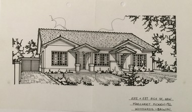
Drawing - Property Illustration, Margaret Picken, 585 & 587 High Street, Kew East, 1992
... 585 & 587 High Street, Kew East...585 & 587 high street - kew east (vic).... - kew east (vic). 585 + 587 HIGG ST., KEW / MARGARET PICKEN ~92 ...After training as a Cartographic Draftsman within the mining industry, I worked as a property illustrator for real estate firms in the eastern suburbs of Melbourne for 23 years from 1983. I initially photographed houses with a Polaroid camera and made a 'thumbnail' sketch while there. The photos were used to scale off a sketch in pencil and then that sketch was overlaid with drafting film and the 'pen and ink' completed. The pens I used were the Rotring ‘Rapidigraph’ drafting pens. The ink was also made by Rotring (German).The film was ‘Rapidraw’, polyester drafting film, double matte. It takes a very fine line and doesn’t bleed. As well as house sketches, there were often floor plans and site plans ordered. Aerial sketches were ordered when the property needed an overall view. (Margaret Picken, 2020)This drawing is one of a series created by Margaret Picken for a number of real estate agents in Melbourne between 1983 and 2005. Each work is signed and dated by the artist.Gift of Margaret Picken, 2020Pen and ink architectural drawing on drafting film of 585 & 587 High Street, Kew by Margaret Picken.585 + 587 HIGG ST., KEW / MARGARET PICKEN ~92 / WOODARDS ~ BALWYNartist -- margaret picken 1950-, architectural drawings -- houses -- kew (vic.), 585 & 587 high street - kew east (vic). -
 Kew Historical Society Inc
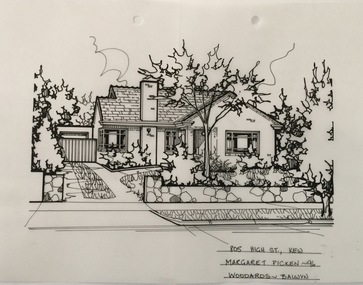
Drawing - Property Illustration, Margaret Picken, 805 High Street, Kew East, 1996
... 805 High Street, Kew East...805 high street - kew east (vic)... east (vic) 805 HIGH ST., KEW / MARGARET PICKEN ~96 / WOODARDS ...After training as a Cartographic Draftsman within the mining industry, I worked as a property illustrator for real estate firms in the eastern suburbs of Melbourne for 23 years from 1983. I initially photographed houses with a Polaroid camera and made a 'thumbnail' sketch while there. The photos were used to scale off a sketch in pencil and then that sketch was overlaid with drafting film and the 'pen and ink' completed. The pens I used were the Rotring ‘Rapidigraph’ drafting pens. The ink was also made by Rotring (German).The film was ‘Rapidraw’, polyester drafting film, double matte. It takes a very fine line and doesn’t bleed. As well as house sketches, there were often floor plans and site plans ordered. Aerial sketches were ordered when the property needed an overall view. (Margaret Picken, 2020)This drawing is one of a series created by Margaret Picken for a number of real estate agents in Melbourne between 1983 and 2005. Each work is signed and dated by the artist.Gift of Margaret Picken, 2020Pen and ink architectural drawing on drafting film of 805 High Street, Kew by Margaret Picken.805 HIGH ST., KEW / MARGARET PICKEN ~96 / WOODARDS ~ BALWYNartist -- margaret picken 1950-, architectural drawings -- houses -- kew (vic.), 805 high street - kew east (vic) -
 Kew Historical Society Inc
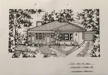
Drawing - Property Illustration, Margaret Picken, 825 High Street, Kew East, 1996
... 825 High Street, Kew East...825 high street - kew east (vic).... east (vic). 825 HIGH ST., KEW / MARGARET PICKEN ~96 / WOODARDS ...After training as a Cartographic Draftsman within the mining industry, I worked as a property illustrator for real estate firms in the eastern suburbs of Melbourne for 23 years from 1983. I initially photographed houses with a Polaroid camera and made a 'thumbnail' sketch while there. The photos were used to scale off a sketch in pencil and then that sketch was overlaid with drafting film and the 'pen and ink' completed. The pens I used were the Rotring ‘Rapidigraph’ drafting pens. The ink was also made by Rotring (German).The film was ‘Rapidraw’, polyester drafting film, double matte. It takes a very fine line and doesn’t bleed. As well as house sketches, there were often floor plans and site plans ordered. Aerial sketches were ordered when the property needed an overall view. (Margaret Picken, 2020)This drawing is one of a series created by Margaret Picken for a number of real estate agents in Melbourne between 1983 and 2005. Each work is signed and dated by the artist.Gift of Margaret Picken, 2020Pen and ink architectural drawing on drafting film of 825 High Street, Kew by Margaret Picken.825 HIGH ST., KEW / MARGARET PICKEN ~96 / WOODARDS ~ BALWYNartist -- margaret picken 1950-, architectural drawings -- houses -- kew (vic.), 825 high street - kew east (vic). -
 Kew Historical Society Inc
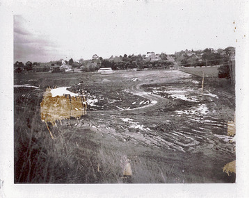
Photograph - Filling in the Outer Circle Railway cutting at East Kew, 1939
... Filling in the Outer Circle Railway cutting at East Kew...high street -- kew east... Outer Circle railway at East Kew. In the background is the metal... line at High St East Kew prior to straightening High St. (c..., showing major works by Kew Council in Kew East working ...W.D. Vaughan (Kew's Civic Century, 1960, pp.195-6) quotes Council Minutes of 1938 and 1939 to record that: "After protracted negotiations between the Council, the Railways Department and the Tramways Board agreement was reached in June, 1938, for the filling of the railway cutting at the Harp Junction and shifting tram tracks to the High Street alignment ... The Outer Circle railway land from Princess Street to Park Crescent was purchased by the Kew Council in October, 1939, for 2,750 [pounds]. The land from Park Crescent to High Street was leased for 1 [pound] per annum. Considerable work was done in levelling the embankments to the original surface level."Important and rare photograph of the period, showing major works by Kew Council in Kew East working on a significant piece of urban infrastructure.Small, original black and white positive (photograph) showing workers and vehicles filling in the tracks of the former Outer Circle railway at East Kew. In the background is the metal bridge with brick piers, adjacent to the Harp Junction. The bridge crossed the cutting, linking the two parts of High Street. Behind the tip truck, painted on the side with the name 'Fowler Quarries' [located Keilor Road, North Essendon], one can see shops [including T.G. Garroway, Cash Grocer] in High Street. What appears to be the City of Kew Steamroller is immediately in front of the bridge. A group of passers-by watch from the bridge and from the road. Annotation in pencil on verso: "Filling in Outer Circle line at High St East Kew prior to straightening High St. (c. Feb 1930?)outer circle railway, railway cuttings, harp junction, high street -- kew east -
Kew Historical Society Inc
Archive (Sub-series) - Subject File, East Kew Women’s Club, 1945-70, 1958
... East Kew Women’s Club, 1945-70...kew east (vic) - community groups...The East Kew Women’s Club was formed on 20 July 1945... The East Kew Women’s Club was formed on 20 July 1945 ...Various partiesReference, Research, InformationSecondary Values (KHS Imposed Order)Most of the original manuscripts of the Club (attendance registers, minutes of meetings, histories etc.,) are kept separately in archival boxes. The reference file contains a copy of the 9-page history of the Club’s history from 1945-65 a newspaper clipping relating to a 25-year anniversary lunch.kew (vic) - history, kew east (vic) - community groups, kew east (vic) - womenkew (vic) - history, kew east (vic) - community groups, kew east (vic) - women -
Kew Historical Society Inc
Plan - Burke Road Junction Estate, East Kew, 1940
... Burke Road Junction Estate, East Kew...Subdivisions -- Kew East (Vic.)... Junction Estate in Kew East. Advertised for sale in 1940... this is an example. Subdivisions -- Kew East (Vic.) Burke Road Junction ...Subdivision plans and real estate flyers/brochures reveal a number of aspects of urban development and history. The Kew Historical Society's collection of these plans, as well as advertisements extracted from magazines, cover key aspects of community development and architectural history of Kew and Kew Eat as well as surrounding suburbs. While most of the plans in the collection were gifted to the Society by the former City of Kew, a number of other plans and advertisements have been donated by individuals, of which this is an example.Original 4-page bifold brochure advertising the Burke Road Junction Estate in Kew East. Advertised for sale in 1940, the estate comprised 16 'Central Allotments' fronting High Street, Kilby Road, and Glass Street. Pages 1 & 4, the front and back covers, includes a panoramic photograph of the junction which features a number of shops still extant, but also with buildings long demolished and redeveloped. These include the petrol station and the dairy on the southeast and southwest corners of Burke Road and High Street/Doncaster Road. The dairy includes a statue of a cow on its roof. Pages 2 & 3 include a detailed plan of the estate. subdivisions -- kew east (vic.), burke road junction estate -
 Kew Historical Society Inc
Photograph - Flooding of the Yarra Valley at Kew East, 1974
... Flooding of the Yarra Valley at Kew East... of the Yarra bordering Kew and Kew East in the north and west... bordering Kew and Kew East in the north and west of the municipality ...Flooding of the Yarra Valley, including that section of the Yarra bordering Kew and Kew East in the north and west of the municipality, was a regular occurrence. Extreme flood events of the Yarra River are recorded to have occurred in 1891, 1901, 1916, 1923 and 1934. The Municipality of Kew's response to these floods was to enact planning decisions restricting residential development in flood prone areas following the floods of 1916, 1921 and 1934. While floods continued after the development of the Upper Yarra Reservoir (construction 1948-57), the regularity and extent of these inundations diminished. During the nineteenth century, the land abutting the south side of the Yarra in Kew was devoted to dairy farming. In the twentieth century, before and after the construction of the Eastern Freeway, much of this low-lying area was used as golf courses and public parks.Late example of the capacity of the Yarra Valley at Kew to flood, even though drainage works and the Upper Yarra Reservoir had reduced their regularity.Original black and white print photograph of Hay's Paddock under floodwater on 16 May 1974. The vantage point of the photographer is Keystone Crescent looking east. Flooding was caused by overflowing water in Glass' Creek and the River Yarra. Annotation verso: "Keystone Cr looking east / 16 May 1974 11.50am"hays paddock, floods, yarra river, glass' creek -
 Kew Historical Society Inc
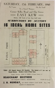
Plan - Subdivision Plan, Subdivision by Auction: 16 Ideal Home Sites, East Kew, 1940, 1940
... Subdivision by Auction: 16 Ideal Home Sites, East Kew, 1940...subdivision plans - kew east (vic)...: of 16 Ideal Home Sites, East Kew, 1940. This significant sale... by Auction of 16 Ideal Home Sites, in East Kew, on 17 February 1940... Sites, East Kew, 1940. This significant sale of land between ...An advertisement for the sale of a subdivision by Auction: of 16 Ideal Home Sites, East Kew, 1940. This significant sale of land between the Kew Golf Course and Willsmere Park led to the streets having a high degree of architectural uniformity.The subdivision in the second year of the war indicates that land sales for homes and speculation continued from the 1930s into the period of the Second World War. There is no indication on the plan that a war is occurring.Single page subdivision plan advertising the sale by Auction of 16 Ideal Home Sites, in East Kew, on 17 February 1940. Streets named in the plan include: Kilby Road, Belford Road, Elm Grove, Willow Grove. Willsmere Park is indicated but not named. The auction was conducted by Beauchamp Brothers. A number of lots are coloured pink on the plan indicating those lots for sale and/or those already sold.subdivision plans - kew east (vic) -
 Kew Historical Society Inc
Photograph, East Kew Women's Club, Carlo Giardina, 1950s
... east kew women's club...The East Kew Women’s Club was formed on 20 July 1945... boy who was sponsored by the East Kew Women's Club...East Kew Women's Club... The East Kew Women’s Club was formed on 20 July 1945 ...The East Kew Women’s Club was formed on 20 July 1945 as an experiment amongst local women, who felt that there was a need for some organised group to give full scope to their various interests and hobbies. In the beginning, they met at the house of their founder, Mrs Eric Thake, 48 Harp Road, East Kew, but the growth and interest was so rapid that it was soon necessary to find a larger meeting place, so the group moved to the Harrier’s Pavilion in Victoria Park, Kew. At the fifth meeting of the group, a committee was formed, and a constitution adopted on 4 December 1945.The Club was aimed to be non-political, non-sectarian and open to women from any locality. The Club’s motto was “To Help others, Improve Ourselves, and Foster the Community Spirit”. The first twenty years of the Club was recorded in a small, nine-page publication “East Kew Women’s Club : Twenty Years 20-7-1945 - 30-7-1965”. Following the closure of the Club in 1973, after twenty-eight years, its records were deposited with the Kew Historical Society and are thus available for research into the history of women’s groups in the post war period in Australia. The Society holds the Club’s Minute Books of Meetings (1953-73), Attendance Registers (1959-73), Visitors Book, and sundry items of print ephemera published by the Club.Black and white photograph of Carlo Giardina, an Italian boy who was sponsored by the East Kew Women's Club. The photograph is stuck into one of their registers.east kew women's club, carlo giardina