Showing 806 items matching "lake view"
-
 Glenelg Shire Council Cultural Collection
Postcard - Postcard - Cape Bridgewater Lakes, Victoria, n.d
... . View of Bridgewater Lakes, from road heading down hill towards... in Australia. View of Bridgewater Lakes, from road heading down hill ...Coloured photo postcard, wavy edge, printed in Australia. View of Bridgewater Lakes, from road heading down hill towards lakes, sea in background.Back: 'PORTLAND VIC.' 'P.37' 'The Bridgewater Lakes near Portland' printed in green, top left. -
 Halls Gap & Grampians Historical Society
Photograph - Coloured, C 2007
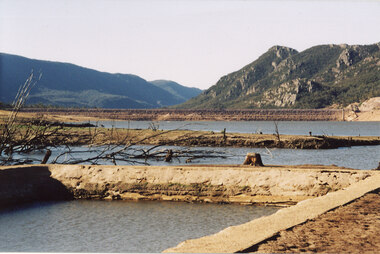
This is a photo of the exposed swimming pool of Myrtlebank, which became exposed in Lake Bellfield during the drought years (2007 - ). The view is looking towards the dam wall.Photo shows an exposed swimming pool (Myrtlebank Pool) in a very low reservoir (Lake Bellfield). There are dead branches in the water behind the pool and the dam wall can be seen in the background.recreation, swimming pool -
 Halls Gap & Grampians Historical Society
Photograph - Coloured, C 2007
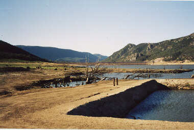
This is a photo of the exposed swimming pool of Myrtlebank, which became exposed in Lake Bellfield during the drought years (2007 - ). The view is looking towards the dam wall and further road through the valley..Photo shows an exposed swimming pool (Myrtlebank Pool) in a very low reservoir (Lake Bellfield). There are dead branches in the water behind the pool and the dam wall and former road through the valley can be seen in the background.recreation, swimming pool -
 Halls Gap & Grampians Historical Society
Photograph - B/W, C 1960s (?)
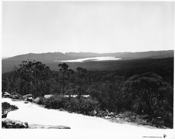
This photo is a view from the road at Reed's Lookout.The photo shows the view from beside a road (the road at Reed's Lookout), across bushland to a large reservoir (Lake Wartook). There is a range of peaks in the background. The road forms the foreground.'Forests Commission, Victoria' inscribed on bottom, right of border. 'Publicity & Public relations Branch, When reproducing please Acknowledge Forests Commission, Victoria, Negative No. 322-34' stamped on back.scenery, lookouts -
 Halls Gap & Grampians Historical Society
Photograph, C 1960s
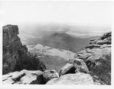
The valley is known as Fyans Valley and the township of Halls Gap. Photo is typical of those taken by the Forestry Commission (Vic) during the 1960s.Photo shows two rocky outcrops in the foreground framing a valley in the distance below. A partial view of a mountain range flanks the valley. Plains of trees and open fields, and also a lake, can be seen beyond the mountain range. Within the valley in the middle of the photo buildings, roads and cleared land can be seen.scenery, fyans valley -
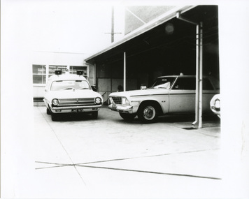 Victoria Police Museum
Photograph (police car)
Photo of the rear yard of the Mobile Traffic Section offices at 145 Chapel St. St.KildaHolden ute, front view, registration number JHE-915, parked at a right angle to a Studebaker Lark, side view. Circa 1964police vehicles; wireless patrol; motor transport branch; motor transport section; holden ute; studebaker lake car -
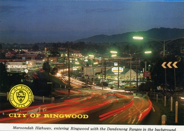 Ringwood and District Historical Society
Postcards, Colorscans (Publishing) Pty Ltd, Various postcards of Ringwood in the 1970s, c. 1968
Postcards - pack of 6: 'Ringwood Victoria - tear off postcard folder - 6 views' (two identical folders); 1. Maroondah Highway, entering Ringwood with the Dandenong Ranges in the background (3303_001.jpg); 2. Aerial View of the City of Ringwood (3303_002.jpg); 3. Eastland Regional Shopping Centre at dusk (3303_003.jpg); 4. The Ringwood Memorial Clock Tower (3303_004.jpg); 5. The Civic Centre (3303_005.jpg); 6. The Ringwood Lake (3303_006.jpg) -
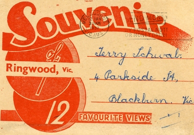 Ringwood and District Historical Society
Souvenir - Folder, Samuel Lee and Co, 12 Black and White Souvenir photos of Ringwood, 1975, 1957
Souvenir photos sent to Terry Schwab in 1957 from Mick who hoped he would have many memories of Ringwood. Donated to the Society by Terry.Buff coloured folder with red printing containing 12 black and white favourite photos of Ringwood. Streetscapes, buildings and Ringwood lake. 4 separated from rest. From Mick. +Additional Keywords: Schwab,Terry -
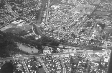 Ringwood and District Historical Society
Photograph, Aerial view taken from slide - Ringwood Lake and surrounds 1969
Written on plastic sleeve, "Aerial view taken from slide - Ringwood Lake 7/8/69". -
 Orbost & District Historical Society
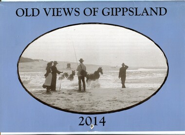
calendar, Old Views of Gippsland 2014, 2013
This is one of a series of calendars published annually by East Gippsland Historical Society.This item is a useful reference tool.A 2014 stapled calendar, titled "Old Views of Gippsland". On the blue coloured front is a black/white photograph of carriage horses being crossed through a lake entrance presumed to be Lake Tyers around the turn of the century C 1900 . It contains early photographs of East Gippsland, one for each month. There is a hole for hanging. The title is at the top and the year at the bottom in black print. -
 Ringwood and District Historical Society
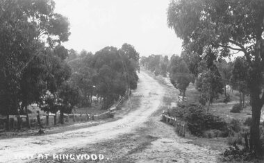
Photograph, Maroondah Highway East, Ringwood- 1870. Sandy Creek, now Ringwood Lake
3 photographs (2 large black and white, 2 small- 1 black and white, 1 sepia) Written on all photographs, "View at Ringwood" Typed below large photograph: "Main St looking east. Right hand side of gully now Ringwood Lake. Written on back of sepia print: "1870, Sandy Creek now Ringwood Lake" -
 Ringwood and District Historical Society
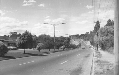
Photograph, Maroondah Highway East, Ringwood in 1973. Eastward view along Maroondah Highway towards Mount Dandenong Road
Black and white photographTyped on back of photograph: "Maroondah Highway by the lake. Looking east towards Mt. Dandenong Rd. - 1973". Ringwood Lake is on the right hand side of the highway. -
 Flagstaff Hill Maritime Museum and Village
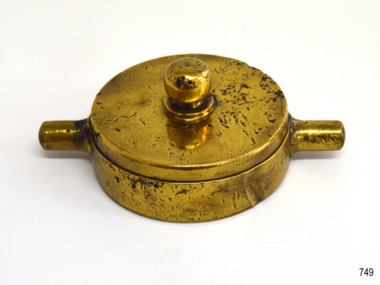
Functional object - Hydrant water Cover, Circa. 1873
The artefact is an impressively solid brass hydrant cap and was recovered from the wreck of the Loch Ard. It is believed to have been associated with the ship’s fresh water supply. Its polished appearance suggests it was also on display in a public part of the vessel, viewed by first and second class passengers as well as operated by the crew. The Loch Ard got its name from ”Loch Ard” a loch which lies to the west of Aberfoyle, and the east of Loch Lomond. It means "high lake" in Scottish Gaelic. The vessel belonged to the famous Loch Line which sailed many vessels from England to Australia. The Loch Ard was built in Glasgow by Barclay, Curdle and Co. in 1873, the vessel was a three-masted square-rigged iron sailing ship that measured 79.87 meters in length, 11.58 m in width, and 7 m in depth with a gross tonnage of 1693 tons with a mainmast that measured a massive 45.7 m in height. Loch Ard made three trips to Australia and one trip to Calcutta before its fateful voyage. Loch Ard left England on March 2, 1878, under the command of 29-year-old Captain Gibbs, who was newly married. The ship was bound for Melbourne with a crew of 37, plus 17 passengers. The general cargo reflected the affluence of Melbourne at the time. Onboard were straw hats, umbrella, perfumes, clay pipes, pianos, clocks, confectionery, linen and candles, as well as a heavier load of railway irons, cement, lead and copper. There were other items included that were intended for display in the Melbourne International Exhibition of 1880. The voyage to Port Phillip was long but uneventful. Then at 3 am on June 1, 1878, Captain Gibbs was expecting to see land. But the Loch Ard was running into a fog which greatly reduced visibility. Captain Gibbs was becoming anxious as there was no sign of land or the Cape Otway lighthouse. At 4 am the fog lifted and a lookout aloft announced that he could see breakers. The sheer cliffs of Victoria's west coast came into view, and Captain Gibbs realised that the ship was much closer to them than expected. He ordered as much sail to be set as time would permit and then attempted to steer the vessel out to sea. On coming head-on into the wind, the ship lost momentum, the sails fell limp and Loch Ard's bow swung back towards land. Gibbs then ordered the anchors to be released in an attempt to hold its position. The anchors sank some 50 fathoms - but did not hold. By this time the ship was among the breakers and the tall cliffs of Mutton Bird Island rose behind. Just half a mile from the coast, the ship's bow was suddenly pulled around by the anchor. The captain tried to tack out to sea, but the ship struck a reef at the base of Mutton Bird Island, near Port Campbell. Waves subsequently broke over the ship and the top deck became loosened from the hull. The masts and rigging came crashing down knocking passengers and crew overboard. When a lifeboat was finally launched, it crashed into the side of Loch Ard and capsized. Tom Pearce, who had launched the boat, managed to cling to its overturned hull and shelter beneath it. He drifted out to sea and then on the flood tide came into what is now known as Loch Ard Gorge. He swam to shore, bruised and dazed, and found a cave in which to shelter. Some of the crew stayed below deck to shelter from the falling rigging but drowned when the ship slipped off the reef into deeper water. Eva Carmichael a passenger had raced onto the deck to find out what was happening only to be confronted by towering cliffs looming above the stricken ship. In all the chaos, Captain Gibbs grabbed Eva and said, "If you are saved Eva, let my dear wife know that I died like a sailor". That was the last Eva Carmichael saw of the captain. She was swept off the ship by a huge wave. Eva saw Tom Pearce on a small rocky beach and yelled to attract his attention. He dived in and swam to the exhausted woman and dragged her to shore. He took her to the cave and broke the open case of brandy which had washed up on the beach. He opened a bottle to revive the unconscious woman. A few hours later Tom scaled a cliff in search of help. He followed hoof prints and came by chance upon two men from nearby Glenample Station three and a half miles away. In a complete state of exhaustion, he told the men of the tragedy. Tom then returned to the gorge while the two men rode back to the station to get help. By the time they reached Loch Ard Gorge, it was cold and dark. The two shipwreck survivors were taken to Glenample Station to recover. Eva stayed at the station for six weeks before returning to Ireland by steamship. In Melbourne, Tom Pearce received a hero's welcome. He was presented with the first gold medal of the Royal Humane Society of Victoria and a £1000 cheque from the Victorian Government. Concerts were performed to honour the young man's bravery and to raise money for those who lost family in the disaster. Of the 54 crew members and passengers on board, only two survived: the apprentice, Tom Pearce and the young woman passenger, Eva Carmichael, who lost her family in the tragedy. Ten days after the Loch Ard tragedy, salvage rights to the wreck were sold at auction for £2,120. Cargo valued at £3,000 was salvaged and placed on the beach, but most washed back into the sea when another storm developed. The wreck of Loch Ard still lies at the base of Mutton Bird Island. Much of the cargo has now been salvaged and some items were washed up into Loch Ard Gorge. Cargo and artefacts have also been illegally salvaged over many years before protective legislation was introduced in March 1982. One of the most unlikely pieces of cargo to have survived the shipwreck was a Minton majolica peacock- one of only nine in the world. The peacock was destined for the Melbourne 1880 International Exhibition in. It had been well packed, which gave it adequate protection during the violent storm. Today the Minton peacock can be seen at the Flagstaff Hill Maritime Museum in Warrnambool. From Australia's most dramatic shipwreck it has now become Australia's most valuable shipwreck artefact and is one of very few 'objects' on the Victorian State Heritage Register.The shipwreck of the Loch Ard is of significance for Victoria and is registered on the Victorian Heritage Register ( S 417). Flagstaff Hill has a varied collection of artefacts from Loch Ard and its collection is significant for being one of the largest accumulation of artefacts from this notable Victorian shipwreck. The collections object is to also give us a snapshot into history so we can interpret the story of this tragic event. The collection is also archaeologically significant as it represents aspects of Victoria's shipping history that allows us to interpret Victoria's social and historical themes of the time. The collections historically significance is that it is associated unfortunately with the worst and best-known shipwreck in Victoria's history. A brass water hydrant cover (or cap); round with a a central knob and two side stanchions for screwing on and off a pipe. the underside has a screw thread. the object was recovered from the wreck of the Loch Ard. Noneflagstaff hill, warrnambool, flagstaff hill maritime museum, shipwreck coast, flagstaff hill maritime village, great ocean road, loch line, loch ard, captain gibbs, eva carmichael, tom pearce, glenample station, mutton bird island, loch ard gorge, hydrant cap, hydrant cover, brass fitting -
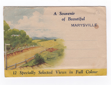 Marysville & District Historical Society
Postcard (item) - Colour photographs, Nucolorvue Productions, A Souvenir of Beautiful Marysville-12 Specially Selected Views in Full Colour, 1950's
An envelope of 12 colour photographs of attractions in and around Marysville in Victoria.An envelope of 12 colour photographs of attractions in and around Marysville in Victoria. These photographs were produced by Nucolorvue Productions in Mentone, Victoria.A Souvenir of Beautiful MARYSVILLE 12 Specially Selected Views in Full Colour Marysville, Victoria, Australia Marysville, 60 miles from Melbourne, is one of nature's/ lovely beauty spots. The invigorating mountain air helps the/ visitor to enjoy the many delightful walks amongst the tall/ timber, or through the fern glades. Apart from many excellent walking trips, Marysville district/ offers ample scope for car trips to the nearby Cumberland Forest,/ Buxton, Narbethong, or the Taggerty Valley. Skiers find Lake Mountain an attraction in the winter, whilst/ the hiker finds ample for his needs in the numerous mountain/ areas. Huge Eucalypt trees, revealing their ramrod straightness up/ to 300 feet in height, are a fitting background to the many/ beautiful creeks and waterfalls. PUBLISHED BY NUCOLORVUE PRODUCTIONS, MENTONE, VICTORIA.nicholl's lookout (image 1), eildon weir (image 2), road to lake mountain (image 3), foot of steavenson falls (image 4), steavenson falls (image 5), bush scene near marysville (image 6), bush track marysville (image 7), bridge and chalet and crossways marysville (image 8), log cabin at marysville (image 9), black spur (image 10), taggerty river (image 11), highest known hardwood tree (image 12), marysville, victoria, nucolorvue productions, postcard, souvenir -
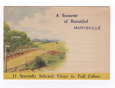 Marysville & District Historical Society
Postcard (item) - Colour photographs, Nucolorvue Productions, A Souvenir of Beautiful Marysville-12 Specially Selected Views in Full Colour, Unknown
An envelope of 12 colour photographs of attractions in and around Marysville in Victoria.An envelope of 12 colour photographs of attractions in and around Marysville in Victoria. These photographs were produced by Nucolorvue Productions in Mentone, Victoria.A Souvenir of Beautiful MARYSVILLE 12 Specially Selected Views in Full Colour Marysville, Victoria, Australia Marysville, 60 miles from Melbourne, is one of nature's/ lovely beauty spots. The invigorating mountain air helps the/ visitor to enjoy the many delightful walks amongst the tall/ timber, or through the fern glades. Apart from many excellent walking trips, Marysville district/ offers ample scope for car trips to the nearby Cumberland Forest,/ Buxton, Narbethong, or the Taggerty Valley. Skiers find Lake Mountain an attraction in the winter, whilst/ the hiker finds ample for his needs in the numerous mountain/ areas. Huge Eucalypt trees, revealing their ramrod straightness up/ to 300 feet in height, are a fitting background to the many/ beautiful creeks and waterfalls. PUBLISHED BY NUCOLORVUE PRODUCTIONS, MENTONE, VICTORIA.nicholl's lookout (image 1), eildon weir (image 2), road to lake mountain (image 3), foot of steavenson falls (image 4), steavenson falls (image 5), bush scene near marysville (image 6), bush track marysville (image 7), bridge and chalet and crossways marysville (image 8), log cabin at marysville (image 9), black spur (image 10), taggerty river (image 11), highest known hardwood tree (image 12), marysville, victoria, nucolorvue productions, postcard, souvenir -
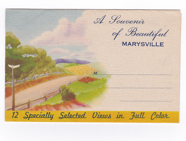 Marysville & District Historical Society
Postcard (item) - Colour photographs, Nucolorvue Productions, A Souvenir of Beautiful Marysville-12 Specially Selected Views in Full Colour, Unknown
An envelope of 12 colour photographs of attractions in and around Marysville in Victoria.An envelope of 12 colour photographs of attractions in and around Marysville in Victoria. These photographs were produced by Nucolorvue Productions in Mentone, Victoria.A Souvenir of Beautiful MARYSVILLE 12 Specially Selected Views in Full Colour Marysville, Victoria, Australia Marysville, 60 miles from Melbourne, is one of nature's/ lovely beauty spots. The invigorating mountain air helps the/ visitor to enjoy the many delightful walks amongst the tall/ timber, or through the fern glades. Apart from many excellent walking trips, Marysville district/ offers ample scope for car trips to the nearby Cumberland Forest,/ Buxton, Narbethong, or the Taggerty Valley. Skiers find Lake Mountain an attraction in the winter, whilst/ the hiker finds ample for his needs in the numerous mountain/ areas. Huge Eucalypt trees, revealing their ramrod straightness up/ to 300 feet in height, are a fitting background to the many/ beautiful creeks and waterfalls. PUBLISHED BY NUCOLORVUE PRODUCTIONS, MENTONE, VICTORIA.nicholl's lookout (image 1), eildon weir (image 2), road to lake mountain (image 3), foot of steavenson falls (image 4), steavenson falls (image 5), bush scene near marysville (image 6), bush track marysville (image 7), bridge and chalet and crossways marysville (image 8), log cabin at marysville (image 9), black spur (image 10), taggerty river (image 11), highest known hardwood tree (image 12), marysville, victoria, nucolorvue productions, postcard, souvenir -
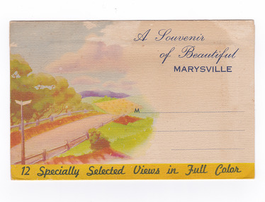 Marysville & District Historical Society
Postcard (item) - Colour photographs, Nucolorvue Productions, A Souvenir of Beautiful Marysville-12 Specially Selected Views in Full Colour, Unknown
An envelope of 12 colour photographs of attractions in and around Marysville in Victoria.An envelope of 12 colour photographs of attractions in and around Marysville in Victoria. These photographs were produced by Nucolorvue Productions in Mentone, Victoria.A Souvenir of Beautiful MARYSVILLE 12 Specially Selected Views in Full Colour Marysville, Victoria, Australia Marysville, 60 miles from Melbourne, is one of nature's/ lovely beauty spots. The invigorating mountain air helps the/ visitor to enjoy the many delightful walks amongst the tall/ timber, or through the fern glades. Apart from many excellent walking trips, Marysville district/ offers ample scope for car trips to the nearby Cumberland Forest,/ Buxton, Narbethong, or the Taggerty Valley. Skiers find Lake Mountain an attraction in the winter, whilst/ the hiker finds ample for his needs in the numerous mountain/ areas. Huge Eucalypt trees, revealing their ramrod straightness up/ to 300 feet in height, are a fitting background to the many/ beautiful creeks and waterfalls. PUBLISHED BY NUCOLORVUE PRODUCTIONS, MENTONE, VICTORIA.nicholl's lookout (image 1), eildon weir (image 2), road to lake mountain (image 3), foot of steavenson falls (image 4), steavenson falls (image 5), bush scene near marysville (image 6), bush track marysville (image 7), bridge and chalet and crossways marysville (image 8), log cabin at marysville (image 9), black spur (image 10), taggerty river (image 11), highest known hardwood tree (image 12), marysville, victoria, nucolorvue productions, postcard, souvenir -
 Marysville & District Historical Society
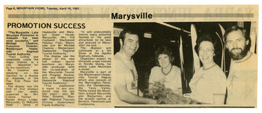
Newspaper (Item) - Newspaper article, Mountain Views, Marysville Promotion Success, 14-04-1981
A newspaper article reflecting on the success of a display to promote Marysville and Lake Mountain. This display was the first of four displays over two weeks which was organised by Mrs. Connie Pannan from Nanda Binya Lodge in Marysville; Counselor Malcolm Reed from the Shire of Healesville and Marylyn Guest House in Marysville; Mrs. Val Cockerell from Blackwood Holiday Flats in Marysville; and Mr. Michael Cheshire from the Westernport Healesville Regional Tourist Authority. The display saw the release of a new full colour tourist brochure on Marysville produced with the co-operation of the Marysville Tourist and Progress Association and Westernport Healesville Regional Tourist Authority. It was deemed to be a most successful promotional event for Marysville and Lake Moutain.A newspaper article reflecting on the success of a display to promote Marysville and Lake Mountain. The Association was formed in November 1907 to promote tourism within the area. This included the physical creation of signage, parklands, roads and walks to various attractions. marysville, victoria, lake mountain, marysville tourist and progress association, newspaper article -
 Marysville & District Historical Society
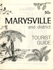
Booklet (Item) - Tourist guide, Ian and Danese Walshe et al, MARYSVILLE and district TOURIST GUIDE, 1982
A tourist guide outlining services, accommodation, activities and places of interest to visit in and around Marysville and the local district.A tourist guide outlining services, accommodation, activities and places of interest to visit in and around Marysville and the local district.marysville, victoria, australia, tourist guide, marysville hotel, castles' store, hawthorne's corner shop, tudor lodge, black spur motel and caravan park, buxton general store, golden fleece roadhouse, marysville garage, burrengeen park, lake mountain, steavenson falls, nanda binya lodge, alpenglow nursery, black spur inn hotel, silver stream trout farm, mccfarlane's grocery, barton's drapery, marysville newsagency, eildon explorer, beauty spot nursery, crossways, pumpernickel, mckenzie's tourist services, blue hills riding school, mountain view horse hire, pitt's garage, maryton park, j l gould sawmill, eildon deer park, eildon weir, maroondah dam, snob's creek, healesville sanctuary, graceburn park, cathedral range, beauty spot walk, tree fern gully walk, michaeldene track, keppel track, woods lookout track, cumberland scenic reserve, cambarville, the big tree, cora-lyn falls, barton's lookout, cumberland falls, sovereign view, wirreanda festival, scenic motel, tower motel, marylands guest house, kooringa guest house, marylyn guest house, mountain lodge, el kanah, marysville hotel motel, buxton hotel motel, black spur inn, buxton caravan park, marysville caravan park, the cumberland, marysville recreation and fun park -
 Marysville & District Historical Society
Booklet (Item) - Leisure guide, Michael Chesire & Associates Pty. Ltd, MARYSVILLE & DISTRICT LEISURE GUIDE-AUTUMN/WINTER, 1986, 1986
A free leisure guide to Marysville and the surrounding district published for Autumn and Winter, 1986. This was produced by Michael Cheshire as a free publication to promote tourism in Marysville and the surrounding district. It includes maps of the Big River Valley, Cumberland Valley, Lady Talbot Forest Drive, the Marysville area, and the township of Marysville. It was released in the autumn of 1986 and was sponsored by the Marysville Tourist & Progress Association. The Association was formed in November 1907 to promote tourism within the area. This included the physical creation of signage, parklands, roads, and walks to various attractions. A free leisure guide to Marysville and the surrounding district published for Autumn and Winter, 1986.marysville, victoria, australia, leisure guide, michael cheshire & associates pty ltd, marysville golf club, blackwood lodges, sir colin mackenzie fauna park, lake eildon, fraser national park, yarra valley wineries, marysville coach tours, kooringa, marylands guest house, lady talbot forest drive, wishing well, taggerty river recreation area, athols abbey, phantom falls, keppel falls, the beeches walking track, marylyn guest house, kufstein inn motel, the cumberland, marysville tourist & progress association, marysville newsagency & general store, crossways restaurant & motel, beauty spot walk, tree fern gully walk, michaeldene track, keppel track, woods lookout track, marysville hotel motel, lake mountain ski hire, marysville recreation and fun park, mytanta horseback safaris, upper big river valley, the big culvert, marysville mountain view horse hire, maryton park, amber view holiday lodges, cathedral restaurant, the top shop, tower motel, menzes garage, beauty spot nursery, marysville ski hire, lake mountain ski school, faraway forest, scenic motel, buxton trout farm, marysville hardware, timbertop steakhouse, marysville trout farm, healesville sanctuary, buxton hotel motel, nanda binya lodge, buxton antique and furniture mart, the black spur inn hotel, alexandra, lake mountain, geoffrey pope & associates -
 Marysville & District Historical Society
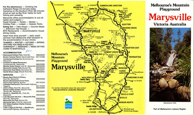
Ephemera (Item) - Tourist Guide, Melbourne's Mountain Playground Marysville Victoria Australia, Unknown
A fold out tourist guide to Marysville and the surrounding district.A fold out tourist guide to Marysville and the surrounding district.marysville, victoria, australia, steavenson falls, marysville golf club, cathedral range, blackwood holiday flats, cumberland holiday inn, kooringa conference and holiday centre, marylyn guest house, marysville caravan park, marysville hotel motel, nanda binya lodge, scenic motel, tower motel, cathedral restaurant, chris's place, danish coffee garden, tudor lodge roadhouse, buxton trout farm, silverstream trout farm, lake mountain ski hire, marysville fun park, mountain view horse hire, jl gould sawmills, marysville dairy, marysville drapery shop, marysville garage, marysville newsagency, top shop -
 Marysville & District Historical Society
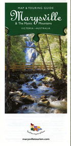
Map (Item) - Map and touring guide, Murrindindi Regional Tourism Association Inc, Marysville & The Mystic Mountains VICTORIA-AUSTRALIA, 08-2002
A fold out map and touring guide of Marysville and the surrounding district published in 2002 by Murrindindi Regional Tourism Association Inc.A fold out map and touring guide of Marysville and the surrounding district published in 2002 by Murrindindi Regional Tourism Association Inc.marysville, victoria, australia, map and touring guide, mystic mountains tourism, the beeches rainforest walk, lake mountain, cambarville, cathedral range state park, the cumberland, abbey green b&b cottages, anastasia fairytale cottage, ashlar cottage b&b, somerled mountain retreat, baree mudbrick cottages, blackwood cottages, camellia cottage, cathedral view b&b, cottage riverside, crossways country inn, dalrymples guest cottages, esa country ministries, hillcrest, keppels hotel motel, kerami house, lomatia lodge, lyell guest cottages, marylands country house, marysville caravan park, marysville holiday cottages, maryton park, melina cottage, moondai farm b&b, mountain lodge marysville, mount cathedral lodge, mystic mountains holiday cottages, nanda binya lodge, rendezvous on murchison, scenic b&b, the hermitage, tower motel, waratah house, willowbank at taggerty, woodlands of narbethong, keppels, lake mountain resort cafe, lanterns at willowbank, mantirri blueberry farm, marysville country bakery, the old woolshed cafe, clearstream olives, uncle fred & aunty val's old style lolly shop, acheron valley alpacas country store & gallery, bruno's art and sculpture garden, country touch, things of sand & stone, willowbank gallery, marysville auto & hardware, marysville newsagency & general store, marysville visitor information centre, narbethong visitor information centre, gallipoli park, keppels lookout, lady talbot drive, steavenson falls, steavenson river, taggerty river, acheron river, black spur trail riding centre, buxton trout farm, lake mountain resort ski hire, lake mountain ski school, marysville district country club, marysville ski centre, narbethong ski hire, rubicon horse riding, country touch tours, murrindindi regional tourism association inc -
 Marysville & District Historical Society
Ephemera (Item) - Visitor's Guide, Shire of Alexandra, ALEXANDRA EILDON MARYSVILLE Visitor's Guide, Unknown
A tourist guide for Alexandra, Eildon and Marysville produced by the Shire of Alexandra.A tourist guide for Alexandra, Eildon and Marysville produced by the Shire of Alexandra.alexandra, eildon, marysville, victoria, australia, tourist guide, steavenson falls, blackwood lodges, marysville hotel motel, the cumberland, gallery restaurant marysville, marysville gallery, cross country ski hire, marylyn guest house, marylands guest house, marysville crafts & gifts, hearts of oak antiques, geoffrey pope & associates, cedron house marysville, amber view holiday lodges marysville, marysville ski hire, lake mountain ski school, fruit salad farm, taggerty general store, arbor green galleries marysville, black spur roadhouse, black spur motel & caravan park, marysville caravan park, the hermitage narbethong, danish coffee garden, maryton park, buxton trout farm, lake mountain outdoor centre marysville, australian bush pioneer's farm, the camel farm and zoo buxton, marysville mountain view horse hire, marysville golf and bowls club, yarrolyn holiday park taggerty, riverland lodge taggerty, beauty spot walk, tree fern gully walk, michaeldene track, keppel track, woods lookout track -
 Marysville & District Historical Society
Newspaper (Item) - Newspaper article, The Age, POCKET GUIDE TO MARYSVILLE, 22-11-2008
A newspaper article on Marysville, its local attractions, places to shop and dine, where to stay and ways of traveling to Marysville. This article was published in The Age on Saturday, November 22, 2008.A newspaper article on Marysville, its local attractions, places to shop and dine, where to stay and ways of traveling to Marysville.marysville, victoria, australia, the age, black spur, marysville visitor information centre, steavenson falls, lady talbot drive, taggerty river, keppel falls, phantom falls, beeches rainforest walk, cambarville, yarra ranges national park, the big tree, cumberland walk, lake mountain, steavenson river, acheron river, buxton bait and tackle, marysville trout and salmon ponds, buxton trout and salmon farm, bruno's art and sculpture garden, villa day spa, cathedral view natural therapies, marysville massage, murchison street, village walk, uncle fred & aunty val's old style lolly shop, country touch gallery, manical mechanicals, hidden talent craft gallery, carmyle farm boutique, marysville community market, marysville patisserie, marysville country bakery, fraga's cafe restaurant, terracotta room, marylands country house, the cumberland, mantirri blueberry farm, narbethong, marysville farmers market, the black spur inn, allawah country cottages, barree mud brick cottages -
 Marysville & District Historical Society
Map (Item) - Tourist map, Mystic Mountains Tourism, OFFICIAL VISITORS' MAP MARYSVILLE LAKE MOUNTAIN, Unknown
A visitors' map of Marysville and Lake Mountain produced by Mystic Mountains Tourism for Visit Victoria.A visitors' map of Marysville and Lake Mountain produced by Mystic Mountains Tourism for Visit Victoria.The Marysville and Lake Mountain Visitor Map and Touring Guide has been compiled and/ published by Mystic Mountains Tourism Inc. Copyright./ Production and artwork Graph Attack P/Lmarysville, lake mountain, victoria, australia, visitor's map, official visitors' map marysville lake mountain, buxton, narbethong, taggerty, visit victoria, mystic mountains tourism inc, graph attack p/l, mystic mountains, marysville triangle, marysville visitor information centre, marylands country house, black spur, steavenson falls, lady talbot drive, cambarville, cathedral ranges, wirreanda festival, lake mountain summit walk, summit walk loop, leadbeaters loop, day loop walk, buxton hotel, igloo roadhouse, karmann waters, silverstream b&b cottages, buxton trout and salmon farm, the niche wine bar, buxton post office & general store, choppers buxton roadhouse, woodlands rainforest bungalows, chestnut glade, black spur inn, wombat cottage, abbey lake luxury b&b spa cottages, mystic mountain ski hire & outdoors, pnl 4wdriving, blue views holiday units & ski hire, marapana agistment park & farm stay b&b, danico design, things of sand & stone, mantirri blueberry farm, allawah country cottages, amberview cottages, ashlar cottage b&b, black spur motel & caravan park, blackwood deluxe cottages, blackwood courtyard b&b, dalrymples guest cottages, delderfield, el kanah guest house, fruit salad farm, kerami guest house, keppels hotel, lake mountain-snow gum lodge, lomatia lodge, lyell guest cottages, magnolia house, keppel waters, lyrebird apartments, marysville caravan park, all view spa apartments, riverside cottages, maryton park b&b country cottages, melina cottage, mountain lodge, mystic mountains holiday cottages, nanda binya lodge, rendezvous luxury cottages, scenic b&b motel, the cumberland, south cathedral farm, tower motel, willowbank at taggerty, woodlands rainforest retreat, marysville & district country club inc, mystic mountains ski hire & outdoors, rubicon valley horse riding, marysville trout and salmon ponds, gallipoli park, keppels lookout, cambarville-yarra ranges national park, lake mountain-yarra ranges national park, lady talbot drive-yarra ranges national park, cathedral range state park, steavenson river, taggerty river, acheron river, lake mountain alpine resort, bruno's art and sculpture garden, manical mechanicals, uncle fred & aunty val's old style lolly shop, carmyle farm boutique, crossways historic country inn, fraga's, gilberts restaurant, heights licensed bistro, the old woolshed cafe, cathedral view natural therapies, crystal journey -
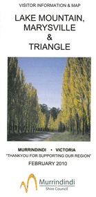 Marysville & District Historical Society
Map (Item) - Tourist map, Murrindindi Shire Council, VISITOR INFORMATION & MAP LAKE MOUNTAIN, MARYSVILLE & TRIANGLE, 02-2010
A visitor information map for Lake Mountain, Marysville and the local district produced by the Murrindindi Shire Council in February 2010. This information guide and map was produced after the 2009 Black Saturday bushfires destroyed most of the township of Marysville.A visitor information map for Lake Mountain, Marysville and the local district produced by the Murrindindi Shire Council in February 2010.Murrindindi Shire Council has made every effort to ensure the information provided at the time/ of printing is correct, but accepts no responsibility for an inaccuracies or omissions.lake mountain, marysville, victoria, australia, visitor information & map, murrindindi shire council, big 4 holiday park taggerty, black spur inn, black spur motel & caravan park, bush creek buddha, buxton hotel motel, cathedral valley farm, chestnut glade, crossways historic country inn, delderfield luxury b&b, kingbilli country estate, marapana agistment park & farm stay b&b, maryton park b&b, pinjarra gardens, sarsens rest, silverstream b&b, tower motel, willowbank at taggerty, wombat cottage, woodlands rainforest retreat, buxton general store and post office, buxton zoo nursery, cathedral view natural therapies, country touch, cross country ski hire, foodworks, highwood health retreat, lake mountain ski hire, lit & beyond, lj hooker, maroondah outdoor equipment/bait & tackle, marysville medical centre, marysville patisserie, marysville ski centre, marysville triangle real estate, marysville visitor information centre, mystic mountains ski hire/outdoors, pat's hairdressing, penni lanes country wares, plant's by shelian -
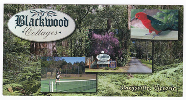 Marysville & District Historical Society
Postcard (Item) - Colour postcard, Blackwood Cottages, Pre 2009
A colour postcard from Blackwood Cottages in Marysville.A colour postcard from Blackwood Cottages in Marysville.12.5.2007 Dear Lorna, Each day is perfect after near/ frost overnight. The colours/ are beautiful - the little/ town seems to glow./ Walked to the Falls on Tuesday/ + saw 3 Lyrebirds - one male/ going through his repetiore of/ local birds./ Yesterday Rod drove me up to/ Lake Mountain where we did/ Look Walk taking in 3 lookouts/ with lovely views./ The cottage is very/ comfortable + well/ appointed. Cockatoos,/ parrots, magpies, kook-/ aburras + magpies all come to my feet! Do hope all goes well with you - love - Jan. MRS N MACDONALD/ 24 PRINCETOWN ROAD/ MOUNT WAVERLEY./ VIC 3149marysville, victoria, australia, blackwood cottages, postcard, souvenir, accommodation -
 Glen Eira Historical Society
Album - Album page, Ripponlea, 192 Hotham Street, Circa 1972
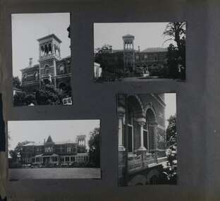
This photograph is part of the Caulfield Historical Album 1972. This album was created in approximately 1972 as part of a project by the Caulfield Historical Society to assist in identifying buildings worthy of preservation. The album is related to a Survey the Caulfield Historical Society developed in collaboration with the National Trust of Australia (Victoria) and Caulfield City Council to identify historic buildings within the City of Caulfield that warranted the protection of a National Trust Classification. Principal photographer thought to be Trevor Hart, member of Caulfield Historical Society. Most photographs were taken between 1966-1972 with a small number of photographs being older and from unknown sources. All photographs are black and white except where stated, with 386 photographs over 198 pages.From Victorian Heritage Database citation for Rippon Lea H0614 https://vhd.heritagecouncil.vic.gov.au/places/427(as at 23/10/2020) Rippon Lea was commenced in 1868 by Frederick Sargood, a most successful politician and merchant. He was born in England in 1834 and arrived in Melbourne in 1850. He soon joined his father's wholesale soft goods firm, spending some time as its manager on the goldfields. Sargood entered the Legislative Council in 1874. He was Victoria's first Minister for Defence in 1883. Sir Frederick Sargood was created CMG. In 1885 and KCMG in 1890 as a reward for his contribution to public life. He died suddenly in 1903. Rippon Lea was designed by the leading firm of architects, Reed and Barnes. Joseph Reed had travelled in Europe in 1863, including northern Italy. When he returned he introduced the use of polychromy. While not the first examples, Rippon Lea and the Independent Church in Collins Street were the best and set a fashion which became a distinctly Melbourne style, particularly used for houses and churches. Its popularity was possible because of the new availability of different coloured bricks. Reed's fine Lombardic Romanesque details soon became debased by others. As Sargood's family grew and his fortunes prospered, Rippon Lea was extended to include 33 rooms - a complete mansion. The cast iron porte cochere and the northern conservatory were added in 1897. The architects were Taylor and Fitts. The ballroom was added in 1882 and remodelled in 1889. Many alterations have changed the interior and exterior during the ownerships of Benjamin Nathan and later his daughter Mrs Louisa Jones in the 1930s and are in their own right of significance. Sir Thomas Bent owned the property from 1903 until 1911 but never lived there. He subdivided much of the land. The original garden dates from about 1868, and it seems that William Guilfoyle of the Botanic Gardens was involved. It was redesigned in a more natural style in the 1880s by Sargood and his head gardener, Adam Anderson. The lake, waterfalls, fernery, hill and grotto are balanced by mighty deciduous trees and conifers. These are interspersed with, but never dominated by Australian species such as eucalyptus and other exotics. The sinuous drive with its carefully prepared approach to the house is notable. The original vegetable gardens, orchard and outer paddocks no longer survive. The shade house is important as the largest known in Australia and possibly the world. Its curved plan and form of construction are particularly notable. It was built about 1884.Page 90 of Photograph Album with five photographs (one landscape and 4 portrait) of Ripponlea - two different views of the front entrance to the mansion, one of the front gates and two different views of the main residence.Handwritten: "Ripponlea" 192 Hotham Street [top right] / North [under top left photo] / Neg 255 Dec 1972 MAIN DRIVE [under bottom left photo] / Neg 238 8 OCT 1966 [under middle right photo] / 88 [bottom right]trevor hart, elsternwick, mansion, hotham street, frederick sargood, reed and barnes, cast iron porte cochere, conservatory, 1860's, 1890's, ballroom, 1880's, benjamin nathan, louisa jones, thomas bent, sir thomas bent, william guilfoyle, adam anderson, lake, grotto, shade house, portico, ripponlea, victorian, sir frederick sargood, architects, polychrome bricks, lombardic romanesque architectural style, rippon lea, taylor and fitts, land subdivisions, gardens, drives, vegetable gardens, orchards -
 Glen Eira Historical Society
Album - Album page, Ripponlea, 192 Hotham Street, Circa 1972
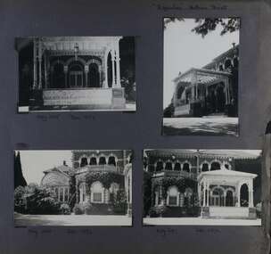
This photograph is part of the Caulfield Historical Album 1972. This album was created in approximately 1972 as part of a project by the Caulfield Historical Society to assist in identifying buildings worthy of preservation. The album is related to a Survey the Caulfield Historical Society developed in collaboration with the National Trust of Australia (Victoria) and Caulfield City Council to identify historic buildings within the City of Caulfield that warranted the protection of a National Trust Classification. Principal photographer thought to be Trevor Hart, member of Caulfield Historical Society. Most photographs were taken between 1966-1972 with a small number of photographs being older and from unknown sources. All photographs are black and white except where stated, with 386 photographs over 198 pages.From Victorian Heritage Database citation for Rippon Lea H0614 https://vhd.heritagecouncil.vic.gov.au/places/427(as at 23/10/2020) Rippon Lea was commenced in 1868 by Frederick Sargood, a most successful politician and merchant. He was born in England in 1834 and arrived in Melbourne in 1850. He soon joined his father's wholesale soft goods firm, spending some time as its manager on the goldfields. Sargood entered the Legislative Council in 1874. He was Victoria?s first Minister for Defence in 1883. Sir Frederick Sargood was created CMG. In 1885 and KCMG in 1890 as a reward for his contribution to public life. He died suddenly in 1903. Rippon Lea was designed by the leading firm of architects, Reed and Barnes. Joseph Reed had travelled in Europe in 1863, including northern Italy. When he returned he introduced the use of polychromy. While not the first examples, Rippon Lea and the Independent Church in Collins Street were the best and set a fashion which became a distinctly Melbourne style, particularly used for houses and churches. Its popularity was possible because of the new availability of different coloured bricks. Reed's fine Lombardic Romanesque details soon became debased by others. As Sargood's family grew and his fortunes prospered, Rippon Lea was extended to include 33 rooms - a complete mansion. The cast iron porte cochere and the northern conservatory were added in 1897. The architects were Taylor and Fitts. The ballroom was added in 1882 and remodelled in 1889. Many alterations have changed the interior and exterior during the ownerships of Benjamin Nathan and later his daughter Mrs Louisa Jones in the 1930s and are in their own right of significance. Sir Thomas Bent owned the property from 1903 until 1911 but never lived there. He subdivided much of the land. The original garden dates from about 1868, and it seems that William Guilfoyle of the Botanic Gardens was involved. It was redesigned in a more natural style in the 1880s by Sargood and his head gardener, Adam Anderson. The lake, waterfalls, fernery, hill and grotto are balanced by mighty deciduous trees and conifers. These are interspersed with, but never dominated by Australian species such as eucalyptus and other exotics. The sinuous drive with its carefully prepared approach to the house is notable. The original vegetable gardens, orchard and outer paddocks no longer survive. The shade house is important as the largest known in Australia and possibly the world. Its curved plan and form of construction are particularly notable. It was built about 1884.Page 91 of Photograph Album with four photographs (two portrait and two landscape) of various external views of Ripponlea.Handwritten: SOUTH [under top left photo] / SOUTH [under top right photo] / WEST [under bottom left photo] / 91 [bottom left]trevor hart, elsternwick, mansion, hotham street, frederick sargood, reed and barnes, cast iron porte cochere, conservatory, 1860's, 1890's, ballroom, 1880's, benjamin nathan, louisa jones, thomas bent, sir thomas bent, william guilfoyle, adam anderson, lake, grotto, shade house, portico, ripponlea, victorian, sir frederick sargood, architects, taylor and fitts, rippon lea, polychrome bricks, lombardic romanesque style -
 Glen Eira Historical Society
Album - Album page, Ripponlea, Hotham Street, Circa 1972
This photograph is part of the Caulfield Historical Album 1972. This album was created in approximately 1972 as part of a project by the Caulfield Historical Society to assist in identifying buildings worthy of preservation. The album is related to a Survey the Caulfield Historical Society developed in collaboration with the National Trust of Australia (Victoria) and Caulfield City Council to identify historic buildings within the City of Caulfield that warranted the protection of a National Trust Classification. Principal photographer thought to be Trevor Hart, member of Caulfield Historical Society. Most photographs were taken between 1966-1972 with a small number of photographs being older and from unknown sources. All photographs are black and white except where stated, with 386 photographs over 198 pages.From Victorian Heritage Database citation for Rippon Lea H0614 https://vhd.heritagecouncil.vic.gov.au/places/427(as at 23/10/2020) Rippon Lea was commenced in 1868 by Frederick Sargood, a most successful politician and merchant. He was born in England in 1834 and arrived in Melbourne in 1850. He soon joined his father's wholesale soft goods firm, spending some time as its manager on the goldfields. Sargood entered the Legislative Council in 1874. He was Victoria?s first Minister for Defence in 1883. Sir Frederick Sargood was created CMG. In 1885 and KCMG in 1890 as a reward for his contribution to public life. He died suddenly in 1903. Rippon Lea was designed by the leading firm of architects, Reed and Barnes. Joseph Reed had travelled in Europe in 1863, including northern Italy. When he returned he introduced the use of polychromy. While not the first examples, Rippon Lea and the Independent Church in Collins Street were the best and set a fashion which became a distinctly Melbourne style, particularly used for houses and churches. Its popularity was possible because of the new availability of different coloured bricks. Reed's fine Lombardic Romanesque details soon became debased by others. As Sargood's family grew and his fortunes prospered, Rippon Lea was extended to include 33 rooms - a complete mansion. The cast iron porte cochere and the northern conservatory were added in 1897. The architects were Taylor and Fitts. The ballroom was added in 1882 and remodelled in 1889. Many alterations have changed the interior and exterior during the ownerships of Benjamin Nathan and later his daughter Mrs Louisa Jones in the 1930s and are in their own right of significance. Sir Thomas Bent owned the property from 1903 until 1911 but never lived there. He subdivided much of the land. The original garden dates from about 1868, and it seems that William Guilfoyle of the Botanic Gardens was involved. It was redesigned in a more natural style in the 1880s by Sargood and his head gardener, Adam Anderson. The lake, waterfalls, fernery, hill and grotto are balanced by mighty deciduous trees and conifers. These are interspersed with, but never dominated by Australian species such as eucalyptus and other exotics. The sinuous drive with its carefully prepared approach to the house is notable. The original vegetable gardens, orchard and outer paddocks no longer survive. The shade house is important as the largest known in Australia and possibly the world. Its curved plan and form of construction are particularly notable. It was built about 1884.Page 92 of Photograph Album with four photographs (three landscape and one portrait) of Ripponlea - views of entrance and left front of mansion.Handwritten: "Ripponlea" Hotham Street [top right] / Neg 245 Dec 1972 [under top left photo] / Neg 246 Dec 1972 [under bottom left photo] / Neg 247 Dec 1972 [under bottom right photo] / 92 [bottom right]trevor hart, elsternwick, mansion, hotham street, frederick sargood, reed and barnes, lombardic, romanesque, cast iron porte cochere, conservatory, 1860's, 1890's, ballroom, 1880's, benjamin nathan, louisa jones, thomas bent, sir thomas bent, william guilfoyle, adam anderson, lake, grotto, shade house, portico, ripponlea, victorian, sir frederick sargood, architects, polychrome bricks, lombardic romanesque style, rippon lea, entrances