Showing 563 items
matching lands and survey
-
 Bendigo Historical Society Inc.
Map - JACK FLYNN COLLECTION: ECHUCA NORTH, November 1953
Map: Echuca North, County of Rodney. Parish plan.By Authority: W.M. Houston, Government Printer. Drawn and Reproduced at the Dept., of Lands and Survey Melbourne, Victoria. November 1953map, rodney, parish plan, echuca north rodney -
 Bendigo Historical Society Inc.
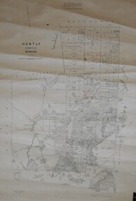
Map - JACK FLYNN COLLECTION: HUNTLY, August 1954
Map: Parish of Huntly, County of Bendigo. Parish plan.By Authority W.M. Houston, Government Printer. Drawn and Reproduced at the Dept, of Lands and Survey, Melbourne, Victoria. August 1954.map, bendigo, parish plan, huntly -
 Bendigo Historical Society Inc.
Map - JACK FLYNN COLLECTION: GOORNONG, August 1953
Map: Township of Goornong, Parish of Goornong, County of Bendigo. Parish plan.By Authority W.M. Houston. Government Printer. Drawn and Reproduced at the Dept., of Lands and Survey, Melbourne, Victoria. August 1953map, bendigo, township, goornong -
 Bendigo Historical Society Inc.
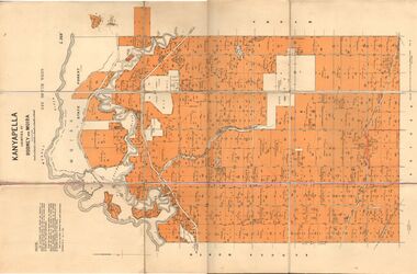
Map - JACK FLYNN COLLECTION: KANYAPELLA, 22/05/1939
Map: Parish of Kanyapella, Counties of Rodney and Moira. Parish plan.By Authority, T. Rider Acting Govt, Printer Melbourne. Drawn and Reproduced at the Dept. of Lands and Survey, Melbourne, Victoria.map, moira, parish plan, kanyapella, counties of rodney and moira -
 Clunes Museum
Map - MAPS, A.C. BROOKS GOVERNMENT PRINTER MELBOURNE
.1 PARISH OF CLUNES, COUNTY OF TALBOT. (3 COPIES) (1) STAMP: DRAWING OFFICE RECORDS COPY, STATE ELECTRICITY COMMISSION OF VICTORIA. ELECTRICITY DEPARTMENT (THIS PLAN MUST NOT BE TAKEN FOR FIELD USE. PLEASE DO NOT DEFACE) C71 ON LEFT BOTTOM CORNER, CLUNES SHEET 1 (2) '19' HANDWRITTEN ON ALL FOUR CORNERS AND PLASTIC TAB FOR HANGING (3) PLASTIC TAB FOR HANGING .2 MAP BECKWORTH COUNTY OF TALBOT (3 COPIES) (1) IN RED: B-61. L.4855. THE ALLOTMENTS COLOURED BROWN ARE FREEHOLD (2) WITH PLASTIC TAB FOR HANGING (3) WITH PLASTIC TAB FOR HANGING. '14' HAND WRITTEN IN ALL 4 CORNERS AND VARIOUS PENCIL NOTATIONS ON THE MAP..1.2 DRAWN AND REPRODUCED AT THE DEPARTMENT OF LANDS & SURVEY MELBOURNE. PRICE 2/- .1 IN PENCIL ON BOTTOM ' 211 ' 20%parish of clunes, electricity supply department, beckworth -
Tarnagulla History Archive
Telegram, March 1862
Donald Clark Collection. A large lot of papers, including this and many other telegrams, were apparently found in the ceiling cavity of the Sandy Creek/Tarnagulla Post and Telegraph Office in the later 20th Century, during building works.Telegram sent from Tarnagulla Telegraph Office from Chas Harding to Frederic Harding at the Department of Lands a& Survey, Melbourne. Text reads "Wait no selling. Gold struck in works'. -
 Bendigo Military Museum
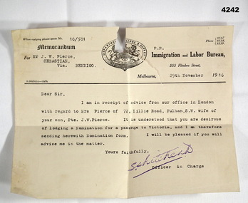
Letter - ADMINISTRATION LETTER, 29.11.1916
The letter from the immigration and Labour Bureau revolves around J.W.Pierce getting his sons wife passage to Australia. The son is also J.W.Pierce No 261 21st Batt AIF who was in France. His wife’s name was Hazel whom he married in late 1916. James returned home in 1919, there is no records in his service documents as to his wife getting passage to Australia. This is George Frederick Pierces brother. George won the DCM. Refer Cat No 4136P for his service details, award and death. Part of the collection of William (Bill) Thomason, refer Cat No 4136P for more items.Letter on official letterhead, yellowed colour, printed in black, ref No 16/581, entries typed in black. At th top is a coat of Arms with “Department of Lands and Survey" around the top.“For Mr J.W. Pierce Sebastion Via Bendigo, 29th November 1916”letters, immigration, military -
Bendigo Historical Society Inc.
Map - VICTORIA, Circa 1926
Map: Map showing Counties, including Railway lines and Geographic features. Compiled and engraved at the Department of Lands and Survey Melbourne, Revised October 1926 ( number 184 in Map Cupboard 1)map, victoria, counties, counties of victoria, geographic features -
 Whitehorse Historical Society Inc.
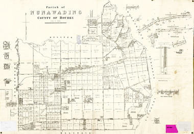
Legal record - Map, Parish of Nunawading, c1930
Office of Lands and survey map, 1864 with many further subdivisions of 1870 onwards added.Office of Lands and survey map, 1864 with many further subdivisions of 1870 onwards added. Boundaries of City of Box Hill included. Note added re Slater's land in Blackburn North. Office of Lands and survey map, 1864 with many further subdivisions of 1870 onwards added. maps, shire of blackburn and mitcham, city of box hill, slater family -
Bendigo Historical Society Inc.
Map - PANNOOMILLOO : COUNTY OF BENDIGO, 1957
Map. Pannoomilloo, County of Bendigo, Pannoobamawm, Milloo, Warragamba, Diggorra, Property Allotments. Drawn and Reproduced at the Department of Lands and Survey,1957. Price 2/-. (number 412 in Map Cupboard 1 ).W.M. Houston, Government Printer, Melbourne.bendigo, hospital -
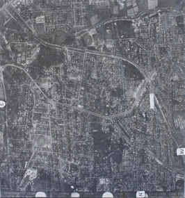 Ringwood and District Historical Society
Photograph, Aerial photograph of Heathmont, Victoria - c.1960s, 1975
Aerial view of Heathmont - black and white photograph on chipboard backing. (Protected by slightly damaged plastic cover which could be removed for clearer image.)Department of Crown Lands and Survey Melbourne, Project Run 31A 27-12-1975, Lens 209 1951M ASL. -
 Bendigo Historical Society Inc.
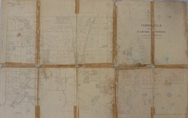
Map - JACK FLYNN MAP COLLECTION: GLADSTONE AND BENDIGO - TARNAGULLA, 13th May 1922
Map 388. Counties of Gladstone and Bendigo a Map of Tarnagulla with Kingower, Glenalbyn, Inglewood, Waanyarra and Laanecoorie boarding. The map is in poor condition and in several pieces. It has been previously taped together. The front page is of red card with white tape along the spine to hold it together, top half Tarnagulla is hand written in black lead on a label with blue trim.By Authority A.J. Mullett, Government Printer, Melbourne. Photo-Lithographed at the Department of Lands and Survey, Melbourne by W.J. Butson. 13.5.22map, bendigo, tarnagulla, tarnagulla, kingower, glenalbyn, laanecoorie, inglewood. -
 Bendigo Historical Society Inc.
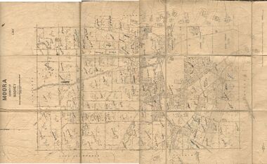
Map - JACK FLYNN COLLECTION: MOORA, 9/10/22
Map: Parish of Moora, County of Rodney. Parish plan.By Authority A.J. Mullet Government Printer Melbourne. Photo Lithographed at the Dept, of Lands and Survey, Melbourne by W.J. Butson. 3.10.22map, rodney, parish plan, moora -
 Bendigo Historical Society Inc.
Map - JACK FLYNN COLLECTION: BONN, 16/07/1919
Map: Parish of Bonn, County of Rodney. Parish plan.By Authority A. J. Mullett. Government Printer, Melbourne. Photo Lithographed at the Department of Lands and Survey. Melbourne by W. J. Butson.map, rodney, parish plan, bonn, rodney -
 Bendigo Historical Society Inc.
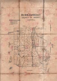
Map - JACK FLYNN COLLECTION: BURRUMBOOT, August 1951
Map: Parish of Burrumboot, County of Rodney. Parish plan.By Authority J.J. Gourley, Government Printer Melbourne. Drawn and Reproduced at the Dept of Lands and Survey, Melbourne, Victoria. August 1951map, rodney, parish plan, burrumboot, rodney -
 Bendigo Historical Society Inc.
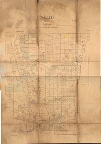
Map - JACK FLYNN COLLECTION: TOOLLEEN, 25/05.1926
Map: Parish of Toolleen, County of Rodney. Parish plan.By Authority, H.J. Green. Govt., Printer. Photo-Lithographed at the Department of Lands and Survey Melbourne. W. J. Butson 25.5.26.map, rodney, parish plan, toolleen -
 Bendigo Historical Society Inc.
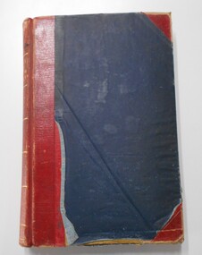
Book - LANDS OFFICE: INDEX LANDS AND SURVEY
Index lands and Survey. Sandhurst, Kangaroo Flat, Eaglehawk, White Hills, And Nerring. Land Sales, Beginning April 17, 1854. The last entry is dated 23.9.74. markings on spine of book are at top 04 in black, in gold lettering index lands and Survey, in black Bendigo, Eaglehawk, Kangaroo Flat White Hills and Nerring, near the bottom is the letter B in black, a white sticker with the letters VV. Read in conjunction with 2239 (a to g), located in Box 77.lands office, index, survey -
Whitehorse Historical Society Inc.
Map, Melbourne and suburbs, 1923
Section of map 'Melbourne and Suburbs' compiled at the Department of Lands and Survey, Melbourne by E. S. Hilcke, March 1923, reprinted 1940.Section of map 'Melbourne and Suburbs' compiled at the Department of Lands and Survey, Melbourne by E. S. Hilcke, March 1923, reprinted 1940. Scale 40 chains: 1 inch. - Shire of Blackburn and MitchamSection of map 'Melbourne and Suburbs' compiled at the Department of Lands and Survey, Melbourne by E. S. Hilcke, March 1923, reprinted 1940.department of lands and surve, melbourne and suburbs -
 Warrnambool and District Historical Society Inc.
Original Document, Map: Agricultural area of Ballangeich 1865, 1865
George Eddington arrived in Australia in 1839 and named and established property in 1841 calling the property Ballangeich after a Pass near his home town of Stirling in Scotland. It is situated 151 miles west of Melbourne and to the south of Mortlake and was originally part of the Mortlake shire, which was proclaimed 26th Jan 1864. Nearest streams are the Hopkins Riverand Lyall and Drysdale creek running through good agricultural land. This map relates to the breaking up of large runs which the Victorian government enabled through selection acts of the 1860's. The previously larger runs which were mainly cattle and sheep based were now more open to closer settlement and a greater variety in farming.The lots range in size from approximately 50 acres to around 600 acres.Some areas are set aside for reserves. By 1886 the population of Ballangeich had grown to around 600 with an hotel, three state schools and a church.Tri weekly coaches ran to Colac, Warrnambool and Camperdown providing access to supplies mail and communication. This map is typical of many which were produced in the 1860's in Victoria during a significant period of Victoria's and Warrnambool district history.Rectangular light card paper with black text showing allotments of land The area is coloured in green with scale at bottom right cornerAt the top: Plan of the Agricultural area of Ballangeich 1865 At the bottom left: Prepared by the Board of Lands & Works in accordance with the Amending Land Act 1865 Lands & Survey Office Melbourne 13th April 1865. With signaturehistory of warrnambool, ballangeich, land surveys victoria 1865, lands act 1865 victoria, ballangeich map 1865 -
 Stawell Historical Society Inc
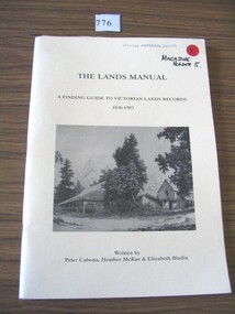
Book, Peter Cabena, Heather McRae & ElizabethBladin, The Lands Manual - A Finding guide to Victorias Lands Records 1836-1983, 1989
The Purpose of this manual is to describe the documentary archives of the Department of Crown Lands and Survey (Lands Department) and Explain, how they can be used for historical researchYellow card Cover Black Print and B/W Photo of two wooden buildings The Lands Manual A Finding guide to Victorian Lands Records 1836-1983 Written by Peter Cabena, Heather McRae & Elizabeth Baldinstawell -
 Bendigo Historical Society Inc.
Map - JACK FLYNN COLLECTION: ARCHDALE, 15/01/1936
Map: Parish of Archdale, County of Gladstone. Parish plan. The Allotments have been coloured in with pencil.By Authority H.J. Green, Government Printer Melbourne. Drawn and Reproduced at the Dept, of Lands and Survey, Melbourne, Victoria. 15/01/36map, gladstone, parish plan, archdale , gladstone -
Bendigo Historical Society Inc.
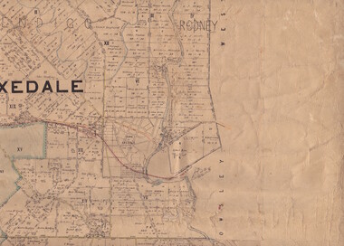
Map - WELLSFORD : COUNTY OF BENDIGO, 6-10-03
Map. Wellsford, County of Bendigo, Bagshot, Ellesmere, Axedale, Hunty, Sandhurst, Strathfieldsaye. Photo-Lithograph ed at the Department of Lands and Survey Melbourne. 6-10-03. (number 21 in map cupboard 1)T.E. McGearsonmap, bendigo, wellsford -
University of Melbourne, Burnley Campus Archives
Plan, Plan of Richmond Park, 1872
Plan of Richmond Park L4461. Shows Horticultural Society's Garden without extra land used for Field Station (see 11.0363, but earlier). Photo-lithographed at the Department of Lands and Survey, 6th Sept. 1872.Handwritten notes on reverse and another railway line marked in pencil.richmond, parks, field station -
 Bendigo Historical Society Inc.
Map - Parish of Strathfieldsaye
Map owned by Henry Thomas (Jack) Qualtrough who worked for the Victorian Forestry Commission. Shire of Strathfieldsaye County of Bendigo canvas backed map. L5169. Includes Axedale, Kimbolton, Eppalock and Sedgewick. Photographed/Lithographed for the Department of Lands and Survey Melbourne by T E McGauran 24.3.07. Price 1/-.map, axedale, kimbolton, sedgewick, eppalock -
Bendigo Historical Society Inc.
Map - FRED COWIE COLLECTION: AERIAL MAPS OF HEATHCOTE/EPPALOCK, 28-9-1960
Map, Heathcote C2, Township of Heathcote, Melbourne Road through town branching off to Bendigo & Echuca. Aerial Survey of Victoria. Photo-map prepared by Department of Crown Lands and Survey from photographs taken in 1960. Copied photographically at the Central Plan Office.Fred Cowie,46 McIvor Rd,Bgo..Central Plan Officemap -
Bendigo Historical Society Inc.
Map - FRED COWIE COLLECTION: AERIAL MAPS OF HEATHCOTE/EPPALOCK, 28-9-60
Map, Heathcote C4, Aerial Survey of Victoria,Photo-map prepared by Department of Crown Lands and Survey from photographs taken in 1960. Copied photographically at the Central Plan Office.Date 28-9-60,C.P.O.Neg.No.21590.Scale 4 inches to 1 mile. Fred Cowie,46 McIvor Rd,Bgo..Central Plan Office.map -
Clunes Museum
Administrative record - BOOK, GARDEN LICENCE 5/
RECEIPT BOOK. DEPARTMENT OF LANDS AND SURVEY. LICENCE TO ENTER UPON CROWN LANDS NOT EXCEEDING IN AREA ONE ACRE AS SPECIFIED, HEREUNDER FOR PURPOSE OF GARDEN AND RESIDENCE.BLUE COVERED RECEIPT BOOK CONTAINING PAYMENTS FOR GARDEN LICENCE NOd 188181 TO 188200 DATED MARCH 1885 TO NOVEMBER 1885local history, local gov., council, licence, garden -
 Bendigo Historical Society Inc.
Document - LANDS OFFICE - CROWN LANDS SURVEYED AND SOLD SANDHURST - 1857 - 1879, 1857 - 1879
Journal: black hard cover with buff spine and corners. Contains details of crown land surveyed and sold, district of Sandhurst. Double pages numbered on top right, page columns - parish, town lands, particulars, survey fees, date of survey, date of sale, auction, selection price per acre, total amount, purchaser. No index. On spine '08' 'Bendigo A' 26th June 1857 to 1879 (?)Lands Officeplace, land sales, lands office, crown land, land surveys, bendigo, sandhurst -
Bendigo Historical Society Inc.
Map - PANNOOMILLOO : COUNTY OF BENDIGO, 17-12-13
Map. Pannoomilloo, County of Bendigo, Pannoobamawm, Warragamba, Milloo, Diggorra. Photo-Lithographed at the Department of Lands and Survey, Melbourne by W.J. Butson 17-12-13, Price 1/-. (number 82 in map cupboard 1)W.J. Butson.map, bendigo, pannoomilloo -
 Bendigo Historical Society Inc.
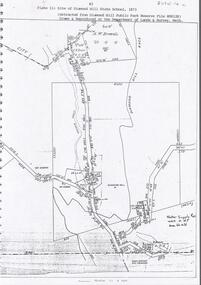
Document - DIAMOND HILL STATE SCHOOL SITE
Map (copy) showing the site of Diamond Hill State School, 1873. On top of page 'extracted from Diamond Hill Public Park Reserve File RS8128, drawn and reproduced at the Department of Lands and Survey, Melbourne'bendigo, education, diamond hill state school