Showing 5241 items
matching level
-
 Glenelg Shire Council Cultural Collection
Photograph - Photograph - Quarry, Cape Grant, n.d
Port of Portland Authority Archivesport of portland archives, cape grant quarry -
Tatura Irrigation & Wartime Camps Museum
Photograph, Cattanach Canal, 1957
Taken by the photographer for Victoria State Rivers and Water Supply Commission.Large black and white photograph. Water in lowest level of canal, three levels of embankment shown on either side, rock fill left foregroundBelow photo: "Cattanach Canal"irrigation, victoria state rivers and water supply commission, cattanach canal -
Phillip Island and District Historical Society Inc.
Photograph
Part of collection of Photographs donated to the Museum by the family of the late Mr. Jack Jenner. (1977)Black & White Photograph of Sea below Cape Woolamai(Written on side of photograph) "Cape Woolamai - 375' above sea level"local history, photography, photographs, slides, film, view cape woolamai, phillip island, black & white photograph, jack jenner, coastline cape woolamai -
Federation University Historical Collection
Equipment - Scientific Instrument, T. Cooke & Sons Ltd, Theodolite, early 1900s
The theodolite is used in surveying and measures vertical and horizontal angles. Placed on a tripod, it is used to find angles in road building, tunnel alignment and other civil engineering work. The theodoliteTheodolite with four levelling screws. External focusing.ballarat school of mines, surveying, engineering, cooke, theodolite, scientific instrument -
 Victorian Aboriginal Corporation for Languages
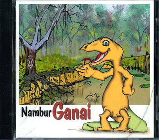
CD-ROM, Yirruk Tinnor Gunnai Language Program, Nambur Ganai : an interactive Indigenous language program, 2000
Accompanying workbook also available for beginner levelCD-ROMganai, curriculum development -
 Queenscliffe Maritime Museum
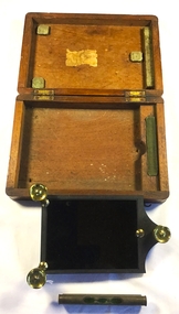
Instrument - Solar reflector
Various artifacts from the steamship 'Wattle'. The Steam Tug Wattle, a steel ship, was built as a harbor tug in 1933. Steam is supplied from a two-furnace Scotch Marine wet-back boiler which was originally fired with dewatered and filtered waste oil but has recently been converted to burn distillate for environmental and maintenance reasons. It was launched at Cockatoo Island on 27 June 1933 by Cockatoo Docks & Engineering Co. Ltd. (CODECO) on order from the Commonwealth Shipping Board. Now fully restored it operates excursions in Port Phillip and the Yarra.Solar Reflector with spirit level in wooden boxst wattle, navigational intruments -
 Otway Districts Historical Society
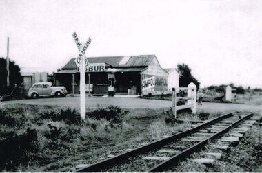
Photograph, Laver's Hill General Store, c.1945, c.1945
Lavers Hill General Store, or more usually, Hampshire's Store, was owned initially for two years by Hampshire and Hutley, and then for 17 years by Mr and Mrs P. Hampshire (senior) who serviced the area including during the Depression. On their retirement their son, Percy, went into partnership with Leo Brauer for four years, and then ran it with his wife, Nea, for a further eight years until the store burnt down. The Store was a placed where the community congregated. It was a place where people met or waited for the train or the Cream Bus or the Mail Bus. Inside it was a place where you could buy groceries, fruit and vegetables, footwear, petrol, and so on. It was a place where children could buy a big stick of licorice for a halfpenny or 3d. worth of broken biscuits. Blackwood Gully Tea Rooms now stands in its place. B/W. Laver's Hill General Store, c.1945, with petrol bowser and sedan outside, and the level crossing to the right and the level crossing sign midfield.lavers hill; general store; railways; petrol bowser; hampshire; hutley; leo brauer; -
 Bendigo Historical Society Inc.
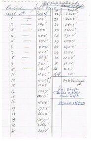
Document - CARLISLE GOLD MINE - SHAFT DEPTH
Page from a note book with the level numbers and their depth and Sills. Goes from level 1 to level 32 at 3430 feet. A Well depth of 30 feet for a total of 3460 feet. Notes taken from Mines Dept. Copied 28/1/1970.mine, gold, carlisle, carlisle gold mine, shaft depth, mines dept. -
Glenelg Shire Council Cultural Collection
Photograph - Photograph - Cape Grant Quarry, n.d
Port of Portland Authority Archivesport of portland archives, cape grant quarry -
 Glenelg Shire Council Cultural Collection
Photograph - Photograph - levelling machine, Portland, c. 1970
Port of Portland Authority archivesFront: (no inscriptions) Back: (no inscriptions)port of portland archives, machinery, equipment -
 Federation University Art Collection
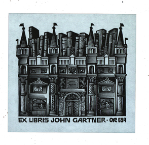
Bookplate, 'Ex Libris John Gartner'
John Gartner was a fine printer and publisher, an author, a noted philatelist, and also collector of Australian banknotes and coins. He was born on 16 July 1914 and was largely self-educated, leaving school at fourteen for work following the death of his father. Gartner developed a strong interest in the history of typography and printing and was apprenticed at the Advocate where his father had been a linotype operator. Aged 17, Gartner bought a hand press and some fonts of type, and in 1937 acquired a platen press from which he set and printed his private press books, published under the imprint of The Hawthorn Press. Gartner had a strong collection of Australian bookplates. He also looked at the work of artists overseas and commissioned personal plates. He subsequently built an international collection with preference for artists who printed from wood. His initial searches were in Belgium and Holland.(http://www3.slv.vic.gov.au/latrobejournal/issue/latrobe-84/t1-g-t7.html) Multi level Gothic buildings with flag holding turretsOR694bookplate, keith wingrove memorial trust, australian bookplate design awards, printmaking -
 4th/19th Prince of Wales's Light Horse Regiment Unit History Room
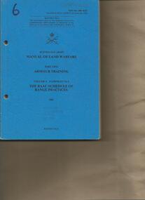
Booklet, Manual of Land Warfare Part 2 Armour Training Vol 4 Pam 2 The RAAC Schedule of Range Practices 1983, 1983
Soft covered booklet dealing with progressive training in all levels from individual qualification courses to sub-unit continuation training and individual training for various levels of promotion.7610-66-108- 8327armour range practices -
Bendigo Historical Society Inc.
Document - NEW CHUM & VICTORIA LINES OF REEF - NEW CHUM SYNCLINE
Handwritten notes mentioning the 9th, 10th and 15th level north and south of the C N Gwynne bdg and distances. Bulk of production from 9 level and intermediate below - ?document, gold, new chum & victoria lines of reef, new chum & victoria lines of reef, new chum syncline, c n gwynne -
 Kew Historical Society Inc
Photograph - 'Fernhurst', 13 Fernhurst Grove, 1978
George Wharton arrived in Melbourne in 1844. An architect and surveyor, he was appointed to lay out the 'Village of Kew' by N.A. Fenwick following the land sales of 1851. A protagonist for Kew's separation from the Boroondara District Road Board, he was elected chairman when Kew achieved municipal status in December 1860. His home, 'Fernhurst', was built in 1866 on eight acres in Studley Park, with a four-storey tower and pyramidal roof. The Italianate home was a prominent Kew landmark. It was demolished in 1979 and replaced by St Paul's College in 1980.Rare colour photograph of what was once a significant mansion in Kew.Original colour positive photograph (Kodak print) of 'Fernhurst' in 1978. Photographed by Stewart West in May 1978, one year before it was demolished, the photograph gives little idea of the large landholding once surrounding the house. Originally accessed from near the corner of Princess Street and Studley Park Road, its gardens had been subdivided in the 1900s and its footprint restricted to 13 Fernhurst Grove. Like many other grand houses, by the 1970s it had been converted into apartments. From the photograph, one can see that the house had retained many of its original features such as the distinctive tower and the wide bow-fronted verandah. The slates on the roof (apart from those on the tower) had been replaced by tiles and the cement render of the exterior painted white. Annotated reverse: "Fernhurst from higher ground level side shot / 7"fernhurst, 13 fernhurst grove -- kew (vic.), george wharton, italianate architecture, vila maria society, st paul's school for the blind -
Bendigo Historical Society Inc.
Map - HUSTLER'S REEF & HUSTLER'S REEF NO 1 MINES - PLAN OF THE HUSTLER'S REEF & HUSTLER'S REEF NO 1 MINES
Plan of the Hustler's Reef & Hustler's Reef No 1 Mines on the Hustler's Line of Reefs, Bendigo Bulletin No 33, Plate No XVI. Plan shows the two shafts and the levels in relation to it. No 9 Level 896 feet 9 inches connecting No 10 Level at 867 feet 2 inches. Plan shows depth of levels and geographical features. Signed by H A Whitelaw, Underground Survey Office, Bendigo. Geographical Survey of Victoria emblem.mining, parish map, hustler's reef & hustler's reef no 1 mines, hustler's line of reefs, plan of the hustler's reef & hustler's reef no 1 mines, h a whitelaw, underground survey office bendigo, geographical survey of victoria, mining -
 Melbourne Tram Museum
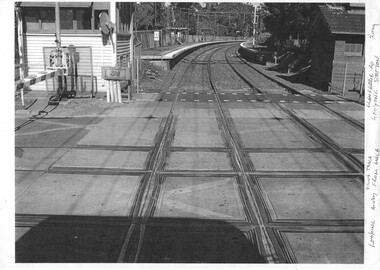
Photograph - Black & White Photograph/s, 2009
Set of two Photographs printed on A4 sheet, photocopy - of the rail tram level crossing at Glenferrie Road, Kooyong showing the rubber inserts and the level crossing - taken from the cab of a train in either direction. Shows the level crossing, platform and track, along with part of the signal box and boom barriers.1 - "Looking away down track from Melbourne - Glenferrie Rd Kooyong Station - 2009" 2 - "Looking towards Melbourne up track - Glenferrie Rd Kooyong Station - 2009"trams, tramways, kooyong, level crossings, glenferrie road, tramway square, railway squares -
 Federation University Historical Collection
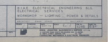
Plan, Ballarat School of Mines M.B. John Workshop Building, c1979
Ewan Jones and Associates were the architect of this building on the SMB Campus. Two plans for new workshops along Albert Street. Later to be refurbished for Ballarat Tech. The first level was designed for Fitting and Machining. The second level for Art, Ceramics, painting and decorating.m.b. john building, workshops, trades, ceramics, ballarat tech, buildings, ewan jones and associates, smb campus, ballarat school of mines -
 Surrey Hills Historical Society Collection
Book, Raheen: a house and its people, 2007
Raheen is a 120 year old Victorian house owned by Richard and Jeanne Pratt. Mrs Jeanne Pratt commissioned the book and this copy was presented to Sue Barnett on a visit by members of the Boroondara Historical Societies. The visit was organised by local member Mr Josh Frydenburg. 92p. ill. bibliog., Raheen was a grand two-storey red brick house in the Italianate Style, with a prominent tower and an arcaded loggia on two levels. This book explores its history, restoration and further development over many years. 92p. ill. bibliog., Raheen was a grand two-storey red brick house in the Italianate Style, with a prominent tower and an arcaded loggia on two levels. This book explores its history, restoration and further development over many years.Endpaper: Surrey Hills Historical Society / Jeanne Pratt / 27/7/2013(mr) ian allen oam, (mr) william lawrence bailieu, ehud barak, (dr) james broadbent, (mr) robert bruce, (mr) george h w bush, (mrs) barbara pierce bush, (mr) arthur calwell, (ms) jane dennithorne, (mr) eamon de valera, (sir) james augustine gobbo, (mr) lloyd hill, (mr) william morris hughes, (lord) (mr) immanuel jakobovits, (mr) philip johnson, (cardinal) (mr) walter kaspar, moshe katsav, (mr) james robert knox, (mr) terence lane, (mr) edward latham, (mr) michael lehany, (dr) (mr) miles lewis, (mr) sam lipski am, (sir) (mr) thomas francis little, (mr) peter lovell, (mr) egidio lunardon, (mr) (cardinal) jean-marie lustiger, (mr) daniel patrick mannix, (sir) (mr) robert gordon menzies, (mr) henry miller, (mr) glen murcutt ao, (mr) benjamin netanyahu, (mr) ngo dinh diem, (mr) phillip nikolitsis, i (eoh) m(eng) pei, (mr) shimon peres, (mr) joseph reed, (mr) yves st laurent, (mr) william salway, (mr) james henry scullin, jessie serle, (mr) justin david simonds, (mrs) heliose waislitz, (miss) heliose pratt, (mr) john wren, (sir) (mr) henry john wrixon, (mr) richard pratt, (mrs) jeanne pratt, raheen, historical buildings, kew, victoria, italianate style, house names -
Federation University Historical Collection
Instrument - Scientific Instrument, A.P. Greenfield & Co, Tripod, c1890
Tripod with brass top and hinges Fits levels 04114 and 04117ballarat school of mines, tripod, surveying -
 Orbost & District Historical Society
vase, first half 20th century
Glass vase. Milky white. Multi-leveled rim in spikes.vase-glass container -
Victorian Aboriginal Corporation for Languages
Booklet with CDROM, Korrawinga Aboriginal Corporation, Yaalam Butchulla : speaking Butchulla, 2004
Learning tool for speaking the Butchulla language for beginners and middle levels.CD-ROM -
 Flagstaff Hill Maritime Museum and Village
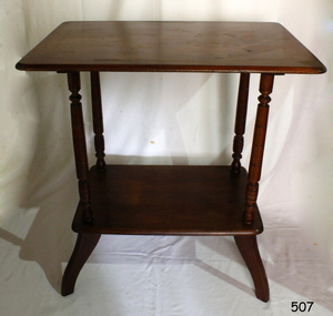
Table
Table wooden with 4 wooden legs with two levels, supported by four columns. Dark varnish finish, some scratching of legs near floor level. Table has noticeable wobble.flagstaff hill, warrnambool, shipwrecked-coast, flagstaff-hill, flagstaff-hill-maritime-museum, maritime-museum, shipwreck-coast, flagstaff-hill-maritime-village -
 Marysville & District Historical Society
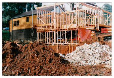
Photograph (Item) - Colour photograph, Unknown
A colour photograph taken during the construction of Arbor Green Cottage in Marysville. This cottage, along with most of the buildings in the township, was destroyed in the 2009 Black Saturday bushfires.A colour photograph taken during the construction of Arbor Green Cottage in Marysville.1 Falls Rd M'sville./ The future ahead./ The Arbor Green Galleries/ 3 Levels.marysville, victoria, australia, photograph, accommodation, arbor green cottage, 2009 black saturday bushfires -
 Kew Historical Society Inc
Photograph - Flooding of the Yarra Valley at Kew, 1974
Flooding of the Yarra Valley, including that section of the Yarra bordering Kew and Kew East in the north and west of the municipality, was a regular occurrence. Extreme flood events of the Yarra River are recorded to have occurred in 1891, 1901, 1916, 1923 and 1934. The Municipality of Kew's response to these floods was to enact planning decisions restricting residential development in flood prone areas following the floods of 1916, 1921 and 1934. While floods continued after the development of the Upper Yarra Reservoir (construction 1948-57), the regularity and extent of these inundations diminished. During the nineteenth century, the land abutting the south side of the Yarra in Kew was devoted to dairy farming. In the twentieth century, before and after the construction of the Eastern Freeway, much of this low-lying area was used as golf courses and public parks.Late example of the capacity of the Yarra Valley at Kew to flood, even though drainage works and the Upper Yarra Reservoir had reduced their regularity.Original black and white print photograph of the low-lying land at East Kew under floodwater on 16 May 1974. The photograph is taken from 43 Kellett Grove.Annotation verso: "Kellett Gve No.43 / Flood Level / 16 May 1974 11.40am"floods, yarra river, kellett grove -
Glenelg Shire Council Cultural Collection
Photograph - Photograph - Cape Grant Quarry, n.d
Port of Portland Authority Archivesport of portland archives, cape grant quarry -
 Geoffrey Kaye Museum of Anaesthetic History
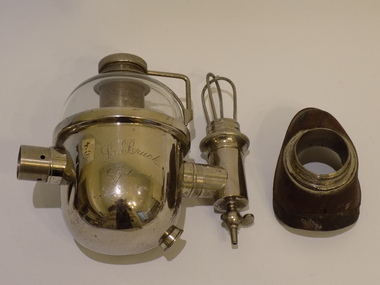
Inhaler, Bruck, 1908
The Bruck Inhaler is a modification of the Clover Inhaler, designed by Lambert Bruck. Bruck added a glass dome which enabled the level of ether to be monitored during administration. This was a revolutionary change as it removed guess work from the process.The Bruck Inhaler is a historically, aesthetically and scientifically significant piece. The basic design is based on the Clover Inhaler, but with a rounded bottom. The idea of a glass viewing window was possibly inspired by Wilson-Smith Inhaler. The Bruck Inhaler is historically significant as it is the first inhaler to be made with a completely clear lower glass section. This improved the usability for the ether administrator, and eliminated much of the guesswork associated with dosage and ether levels, which in turn improved the patient experience. This piece provides a strong local link to both anaesthetic and general medical practice at the turn of the century. The design is credited to Ludwig Bruck of Sydney, and was presumably manufactured in the same area. Bruck, as the attributed designer, holds much relevance to the significance of the object, as connected with him is much historical information about the social context of medical practice. Ludwig Bruck was a prominent figure in the medical industry. He started his medical career in Sydney as a Medical Transfer Agent, and later owned a shop at 16 Castlereagh Street, Sydney. This business is listed in the 1903 Register of Firms as a Medical Agent and Importer of Medical Instruments and Books. Bruck was vocal as a journalist and published analyses of medical statistics, as well as the well known Australasian Medical Dictionary and Handbook, which included the “List of Unregistered Medical Practitioners”. Ludwig Bruck was an immigrant. He was of German descent, which placed him in a precarious position within Sydney society during the turn of century. Bruck conducted several public conversations with prominent members of the Australian Natives Association through the Sunday News in regards to his disagreement of the employment of medical practitioners by the ANA specifically to corroborate their health insurance policies. He was also a stalwart supporter of the Australian arm of the British Medical Association, being the publisher of the first and subsequent editions of The Australian Medical Gazette. Bruck chose to end his life with a combination of poison and chloroform on 14 August 1915, after being accused of trading with the enemy during World War One. His suicide note stated his horror at leaving his business partner to deal with the tarring of his reputation as the reason for his decision. The Bruck Inhaler has aesthetic significance as it is a beautiful example of turn of the century surgical design and craftsmanship. Aseptic methods of surgery were well known by 1909, and the aesthetic design of the Bruck Inhaler conformed to these principles. The ability for the surgeon to unscrew, clean and sterilize each part of the Inhaler contributes to the streamlined design of the piece. The Buck Inhaler holds scientific significance. There is the capacity for further research to be undertaken on the object. Geoffrey Kaye often collected multiple examples of equipment, usually one for reverse engineering and another for teaching. There are currently two examples of the Bruck Inhaler in the collection, presenting an opportunity for further technical research on the object. The inhaler is oval shaped with one half made of glass to allow observation of the ether level. A vertical cross tube, 22mm in diameter passes between the face-piece and the bag [missing]. There is a stopcock for admission of oxygen or nitrous oxide opposite the bag attachment. There is a central tube, 28mm in diameter, with controllable ports on either side. There is also a tear-drop shaped fask mask.Hand engraved on side of base: L. Bruck / Sydneyclover, joseph, bruck, lambert, inhaler, rebreather, nitrous oxide, oxygen, williams, probyn -
Glenelg Shire Council Cultural Collection
Photograph - Photograph - Cape Grant Quarry, n.d
Port of Portland Authority Archivesport of portland archives, cape grant quarry -
Glenelg Shire Council Cultural Collection
Photograph - Photograph - Cape Grant Quarry, n.d
Port of Portland Authority ArchivesBack: Purple PHT stamp -
Glenelg Shire Council Cultural Collection
Photograph - Photograph - Cape Grant Quarry, 27/08/1953
Port of Portland Authority ArchivesBack: Purple PHT stampport of portland archives, cape grant quarry -
 Federation University Historical Collection
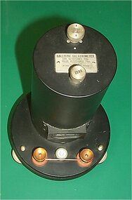
Scientific Instument, Ballistic Gavanometer
Galvonometer in an upright cylindrical metal case on a circular base, with levelling feet.scientific instrument, galvanometer, ballistic galvanometer