Showing 609 items
matching lower plenty river
-
 Greensborough Historical Society
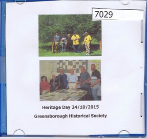
CD-ROM, Greensborough Historical Society Heritage Day 2015, photographs by Marilyn Smith, 24/10/2015
Photographs of participants in Plenty River Trail walk led by Noel Withers 24/10/2015, and at following BBQ. CD-ROM containing 65 photographs, with written background notesplenty river trail, greensborough historical society -
 Greensborough Historical Society
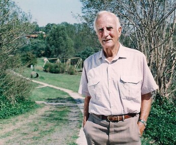
Photograph - Digital Image, Tom Vickers on the Plenty River Trail, 1985_
Tom Vickers on the Plenty River Trail circa 1985.Tom Vickers was a prominent member of the community and a local pharmacist.Digital copy of colour photographvickers family, tom vickers, plenty river trail -
 Greensborough Historical Society
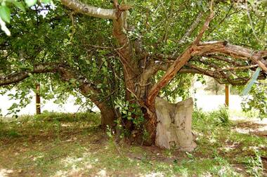
Photograph - Digital Image, Batman Apple Tree 2018, 2018_
The Batman apple tree is located on the Plenty Trail north of Greensborough. The tree dates from the mid 1800s and is said to have been purchased from John Batman's estate after his death.Digital copy of colour photographbatman apple tree, john batman, plenty river trail -
 Greensborough Historical Society
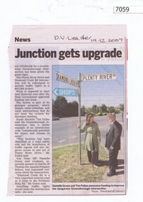
Newspaper Clipping, Junction gets upgrade, 19/12/2007
Article on the upgrade of the Diamond Creek Road and Plenty River Drive intersection. Black and white text, colour imageplenty river drive greensborough, diamond creek road greensborough -
 Greensborough Historical Society
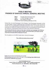
Document, Friends of Banyule Annual General Meeting 2019, 28/11/2019
Friends of Banyule has been involved in campaigns relating to the North East Link, the environment and the River Yarra (Speaker for this Meeting)1 p. text, col. & black and white illus., with 2 leaflets on NorthEast Link distributed at the meetingyarra river, north east link, friends of banyule -
 Greensborough Historical Society
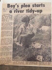
Newspaper Clipping - Digital Image, Boy's plea start Plenty River tidy-up, 09/12/1980
Christopher Foster, age 11, was sick of not being able to find yabbies in the Plenty River. He wrote to a local Councillor and asked that the River be cleaned up.Digital copy of newspaper article, black text and black and white image.plenty river, chris foster -
 Greensborough Historical Society
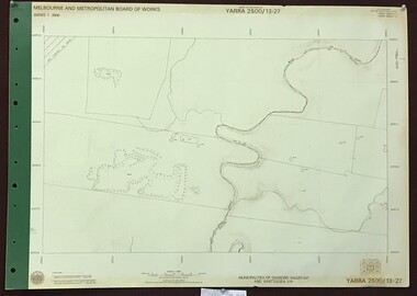
Map, Melbourne and Metropolitan Board of Works. Survey Division, MMBW, Yarra 2500 / 14.28. Yarrambat Park, 1977_09
Melbourne and Metropolitan Board of Works. Yarra 2500 [base map] 14.28. Yarrambat Park. Municipalities of Diamond Valley 257 and Whittlesea 239. Prominent streets include: Bannons Road and Yan Yean Road. Features include the Plenty River.MMBW Map in 1:2500 [scale] series. Cream parchment with green tape reinforcing on edges and punched holes on left edge.mmbw, melbourne and metropolitan board of works, shire of diamond valley, whttlesea, yarrambat - maps -
 Greensborough Historical Society
Map, Melbourne and Metropolitan Board of Works. Survey Division, MMBW, Yarra 2500 / 13.24. Plenty, Memorial Drive, 1979_03
Melbourne and Metropolitan Board of Works. Yarra 2500 [base map] 13-24. Plenty, Memorial Drive. Parish of Morang 3183. Municipalities of Diamond Valley 257 and Whittlesea 239. Prominent streets include: Oatland Road, River Avenue and Memorial Drive. Includes Plenty River and SEC Transmission easement.MMBW Map in 1:2500 [scale] series. Cream parchment with green tape reinforcing on edges and punched holes on left edge.mmbw, melbourne and metropolitan board of works, shire of diamond valley, plenty - maps -
 Greensborough Historical Society
Map, Melbourne and Metropolitan Board of Works. Survey Division, MMBW, Yarra 2500 / 13.26. Yarrambat, Worns Lane, 1978_02
Melbourne and Metropolitan Board of Works. Yarra 2500 [base map] 13.26. Yarrambat, Worns Lane. Municipalities of Diamond Valley 257 and Whittlesea 239. Prominent streets include: Worns Road, North Oatlands Road and Licola Street. Features include Plenty River.MMBW Map in 1:2500 [scale] series. Cream parchment with green tape reinforcing on edges and punched holes on left edge.mmbw, melbourne and metropolitan board of works, shire of diamond valley, whttlesea, yarrambat - maps -
 Greensborough Historical Society
Map, Melbourne and Metropolitan Board of Works. Survey Division, MMBW, Yarra 2500 / 13.23. Plenty, Middle Gorge, 1978_04
Melbourne and Metropolitan Board of Works. Yarra 2500 [base map] 13-23. Plenty / Middle Gorge. Parish of Morang 3183. Municipalities of Diamond Valley 257 and Whittlesea 239. Prominent streets include: Gorge Road, Kurrak Road and Browns Lane. Features include the Plenty River and Plenty Gorge Park.MMBW Map in 1:2500 [scale] series. Cream parchment with green tape reinforcing on edges and punched holes on left edge.mmbw, melbourne and metropolitan board of works, shire of diamond valley, plenty - maps, plenty gorge park -
 Greensborough Historical Society
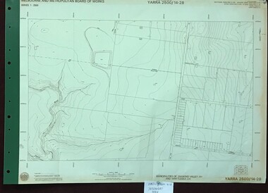
Map, Melbourne and Metropolitan Board of Works. Survey Division, MMBW, Yarra 2500 / 13.27. Morang wetlands, 1977_09
Melbourne and Metropolitan Board of Works. Yarra 2500 [base map] 13.27. Morang wetlands. Municipality of Diamond Valley 257 and Whittlesea 239. Features include the Plenty River and SEC Transmission Line easement. MMBW Map in 1:2500 [scale] series. Cream parchment with green tape reinforcing on edges and punched holes on left edge.mmbw, melbourne and metropolitan board of works, shire of diamond valley, morang - maps -
 Greensborough Historical Society
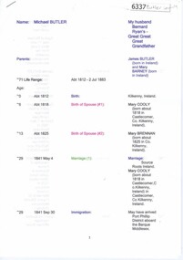
Genealogical Document, Michael Butler and family, 2017_
Michael Butler and his family are recorded as living on the Plenty River in 1840. Later records and Titles give the address as Clear Hills near Greensborough. The location appears to be in Plenty.17 pages, including family tree and copies of titlesbutler family, michael butler, clear hills, plenty -
 Greensborough Historical Society
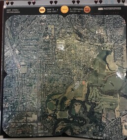
Aerial Photograph, AAM Photographics, Heidelberg AAM1969c 106, 24/11/1991
... Plenty River, South boundary Lower Plenty Road.... Plenty Lower Plenty melbourne One of an overlapping series ...One of an overlapping series of aerial photographs of the Heidelberg/Greensborough areas in 1991, covering the Simpson Barracks, Greensborough & Viewbank. North boundary Nell Street, East boundary Plenty River, South boundary Lower Plenty Road.Laminated colour aerial photographsimpson barracks, greensborough, viewbank -
 Greensborough Historical Society
Map, Municipality of Heidelberg Plan No. 480, 17/10/1948
Map shows streets, buildings, river and major drainage easements in area covered by West boundary Sellars Street, North boundary Yando Street & South boundary Grimshaw Street. Adjoins Map No. 481 to East. Black & white map, features marked in green, gradients in red. Scale: 160 feet to 1 inchgreensborough -
 Greensborough Historical Society
Map, Municipality of Heidelberg Plan No. 481, 23/9/1949
Central area of Greensborough, South boundary Grimshaw Street, showing river and buildings in green and gradients in red. Adjoins Map No. 480 to West.Black & white map with features in red and green. Scale: 160 feet to 1 inch.greensborough, grimshaw street greensborough -
 Greensborough Historical Society
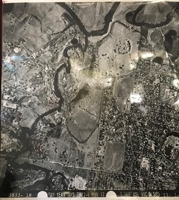
Aerial Photograph, Yan Yean M/S 7922 Run 17 No. 3833-18, 1/11/1984
Covers Viewbank area: North boundary Martin's Lane; South boundary Yarra River & Birrarung Park; East boundary east of Plenty RiverLaminated black and white aerial photograph; adjoins 6227 on west sideviewbank -
 Greensborough Historical Society
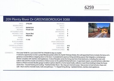
Advertising Leaflet, Barry Plant Greensborough, 209 Plenty River Drive Greensborough, 08/08/2018
Real estate advertisement for 209 Plenty River Drive Greensborough, a 3 bedroom house. This house was sold in July 2018 for $742,000. Previous sales: June 2012 for $490,000; December 1998 $134,000 and December 1985 for $83,000.Real estate advertisement black text and colour photographplenty river drive greensborough -
 Greensborough Historical Society
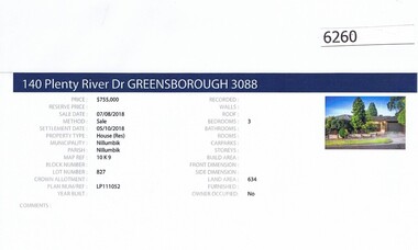
Advertising Leaflet, Barry Plant Greensborough, 140 Plenty River Drive Greensborough, 07/08/2018
Real estate advertisement for 140 Plenty River Drive Greensborough, a 3 bedroom house. This house was sold in August 2018 for $755,000. Previous sales: October 2007 for $425,000; and December 1981 for $72,000.Real estate advertisement black text and colour photographplenty river drive greensborough -
![Newspaper Clipping - Digital Image, Act at home to help the earth [Greensborough Primary School Gr2062], 18/06/2001](/media/collectors/4f729f5697f83e03086015b8/items/5bb9789021ea6716dc37f527/item-media/5bb978bd21ea6716dc382477/item-fit-380x285.jpg) Greensborough Historical Society
Greensborough Historical SocietyNewspaper Clipping - Digital Image, Act at home to help the earth [Greensborough Primary School Gr2062], 18/06/2001
Students from Greensborough Primary School planted trees along the Plenty River, assisted by Mayor of Banyule Councillor Dale Peters.Newspaper clipping, black and white text and colour image.greensborough primary school, plenty river, dale peters -
 Greensborough Historical Society
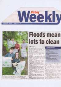
Newspaper Clipping - Digital Image, Barak Bushland Reserve - Floods mean a lot to clean, 02/03/2005
Receding flood water levels have revealed much rubbish. Clean Up Australia day volunteers work throughout Banyule and Nillumbik to collect the rubbish.Newspaper clipping, black and white text and colour image.clean up australia day, plenty river -
 Greensborough Historical Society
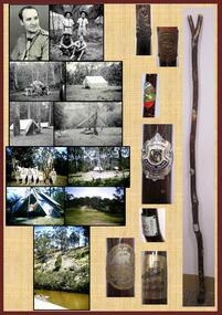
Poster, Lewis C Tulk, My Scout Stave, by Lewis Tulk, 02/02/2018
Lewis Tulk's account of his scouting experiences, including reference to the campsite at Kangaroo Point, Plenty River, Janefield.Laminated poster, with text, black and white and coloured photographs and scout emblem.scouting, lewis tulk -
 Greensborough Historical Society
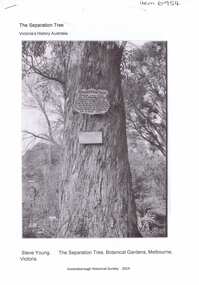
Article, The Separation tree, 2019_
The tree was one of two original red river gums that pre-dated European occupation, and was the site where colonists congregated to celebrate the announcement of Victoria's separation from New South Wales on 15 November 1850. It died as the result of vandalism in 2010 and 2013. Saplings of the original are planted around Melbourne, including along the Plenty River Trail in Greensborough3 p. Wikipedia article; photograph of the tree in the Botanical Gardens, Melbourne (before it was vandalised), and copy of the document of separation of the province of Victoria from the Colony of New South Wales, owned by Colin Boucher..separation tree -
 Greensborough Historical Society
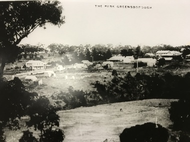
Photograph, The Park Greensborough, 1900c
View of Greensborough Park from Partington's Hill, showing sporting ground, Plenty River, Marble Hall, sparse housing on north side of Main Road, the Farmers' Arms hotel, the Rechabite Hall and Main Road bridge over the the railway line. Marble Hall is the double-storied building on the corner of Main Road.Part of a collection of 5 enlarged photographs dating from the early 1900s.Black and white enlargement of photographgreensborough park, main street greensborough, rechabite hall, farmers' arms hotel, marble hall, greensborough railway -
 Greensborough Historical Society
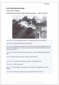
Photograph, Main Road bridge looking to township of Greensborough, 1929c
View of Main Street Greensborough from Partington's Hill including Plenty River bridge and Marble Hall on corner of Carter Street (now Para Road) and Main Street. This view of Greensborough Park shows the old pan toilets, the hawthorn fence line and the rather undeveloped roadside area of the park. Looking up Main Street we see the old Chapman house at the corner of Poulter Avenue and some newer houses below this. The stone river bridge appears to be only a single lane wide and the road approaching the bridge is unsealed. The rail bridge shows evidence of soot from steam trains and at the extreme left of picture the two concrete buildings indicate the line had been electrified. This occurred in 1923. Sparse housing is seen in the Flintoff Street and Grimshaw Street area.Part of a collection of photographic enlargements of views of Greensborough in the early 1900s.Black and white enlargement of photographic imagemain street greensborough, marble hall, greensborough railway, chapman house, greensborough park, poulter avenue greensborough, carter street, para road -
 Greensborough Historical Society
Photograph, Plenty River Bridge Greensborough, 1910c
Early photograph of Main Street bridge over the Plenty River, taken around 1910. Quirk's Tailor shop is seen in the background and a horse and cart coming down the road. The road appears unsealed. Rampant blackberries can be seen growing around the bridge abutments. Part of a collection of photographic enlargements of Greensborough sites.Black and white enlargement of photographic imagemain street bridge, main street greensborough, plenty river greensborough, quirk's tailor shop, blackberry, mckenzie bridge -
![Advertising Leaflet, John McEwen and Co, Heidelberg Park Estate [Lower Plenty], 1913c](/media/collectors/4f729f5697f83e03086015b8/items/5dcfb52321ea671434e9ca4c/item-media/5dcfb56321ea671434ea0352/item-fit-380x285.jpg) Greensborough Historical Society
Greensborough Historical SocietyAdvertising Leaflet, John McEwen and Co, Heidelberg Park Estate [Lower Plenty], 1913c
Copy of auction leaflet for the sale of land fronting the Plenty River. Known as Heidelberg Park, this land is in what is now Lower Plenty. Sale circa 1913Digital copy of auction leaflet, 1 page.heidelberg park, lower plenty, land sales -
 Greensborough Historical Society
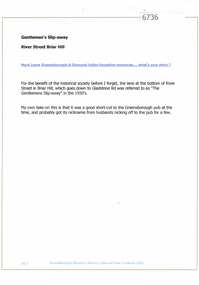
Article and Photograph, Gentlemen's slip away, 2016_
Explanation of the term "gentlemen's slip-away", said to refer to the lane at the bottom of River Street Briar Hill which goes to Gladstone Road - a short cut to the Greensborough Hotel?This photograph and text was copied from a Facebook site. Members are people who lived in the Greensborough area and share their reminiscences of the area with others. The site is administered by a GHS member but is not officially affiliated with the Society. Any information is the opinion of the contributor. Article and photograph sourced from social media.river street briar hill, gladstone road briar hill, greensborough hotel -
 Greensborough Historical Society
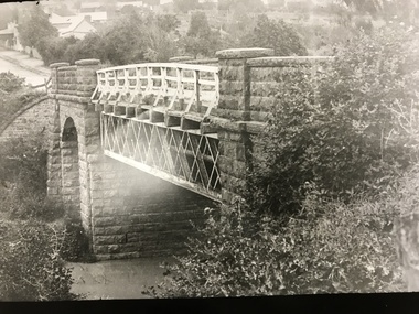
Article and Photograph, Main Street Bluestone bridge, 2017_
Information and photos about the bluestone bridge over the Plenty River in Main Street GreensboroughThis photograph and text was copied from a Facebook site. Members are people who lived in the Greensborough area and share their reminiscences of the area with others. The site is administered by a GHS member but is not officially affiliated with the Society. Any information is the opinion of the contributor. Article and photograph sourced from social media.bluestone bridge greensborough, plenty river, main street greensborough -
 Greensborough Historical Society
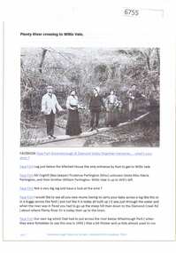
Article and Photograph, Plenty River crossing to Willis Vale, 2016_
Information and photo of members of the Partington family on the log crossing the Plenty River to the family's home at Willis Vale c1905. In the photo are Maria, Prudence and William Partington and Mr Coghill.This photograph and text was copied from a Facebook site. Members are people who lived in the Greensborough area and share their reminiscences of the area with others. The site is administered by a GHS member but is not officially affiliated with the Society. Any information is the opinion of the contributor. Article and photograph sourced from social media.willis vale, partington family, coghill, greensborough -
 Greensborough Historical Society
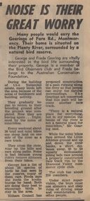
Newspaper Clipping - Digital Image, Noise is their great worry, 21/08/1973
A family living near the Plenty River in Montmorency are concerned about the noise of mini-bike riders and their effect on local bird life. [1973]Digital copy of newspaper article, black text.plenty river montmorency, montmorency