Showing 654 items matching "main road shops"
-
 Eltham District Historical Society Inc
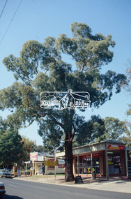
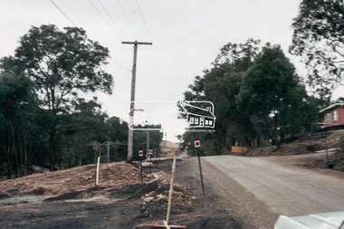
Slide - Photograph, Heidelberg-Kinglake Road, Hurstbridge, c.1992
35mm colour positive transparency Mount - Black and Whiteheidelberg-kinglake road, heritage tree, hurstbridge, hurstbridge shopping centre, infrastructure, roads, shopping centre, significant tree -
 Eltham District Historical Society Inc
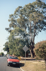
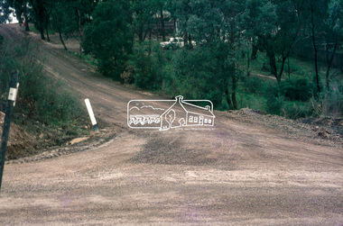
Slide - Photograph, Heidelberg-Kinglake Road, Hurstbridge, c.1992
35mm colour positive transparency Mount - Black and Whiteheidelberg-kinglake road, heritage tree, hurstbridge, hurstbridge shopping centre, infrastructure, roads, shopping centre, significant tree -
 Eltham District Historical Society Inc
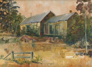
Painting, C. Lillie Brown, Briar Hill Cottage by C. Lillie Brown
Painting by C. Lillie Brown (Caroline) of house at 25 Beaconsfield Road, Briar Hill, formnerly owned by Miss Humphries who ran a lolly shop in the left hand sode of the building. Frequented by children from the Briar Hill school which was opposite. House now demolished.29.2 x 39.1 cm Oil on (Fredrix USA) linen mounted paper board 12" x 16 " (30.5 x 40.6 cm) in standard frame Signed in brown paint lower left C Lillie Brown25 beaconsfield road, briar hill, miss humphries, lolly shop, briar hill school -
 Eltham District Historical Society Inc
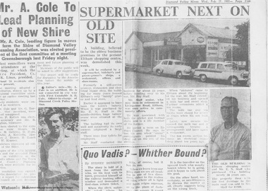
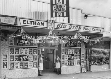
Newspaper clipping, Supermarket next on old site, Diamond Valley Mirror, Wed. Feb 17, 1965, p5, 1965
In February 1965, Staffs Railway Store, the oldest business premises in the Eltham shopping district was demolished. Formerly a self-service grocery, restaurant and electrical repair shop, the building for many years housed Eltham’s only ‘family’ grocer and feed store. Earlier it had appeared to have been the town’s bakery. The building had been purchased in late March 1939 by Mr Eric N. Staff. At the time of E.N. Staff’s purchase there were huge bakers’ ovens located at the rear and the building also had a well and four toilets for employees. When the ‘pictures’ came to Eltham with the opening of the Eltham Public Hall across the road in 1941, Mr E.N. Staff extended the business and opened a milk bar and sweet shop. Further extensions re-established the tea rooms of days gone by. Mr E.N. Staff conducted business for about 15 years before handing over the reins to his son, Ray Staff. When his son Ray took over, the milk bar and tea rooms were closed for several years but the milk bar and was later re-opened and subsequently became a greengrocers and later again, a restaurant. The tea rooms section was converted to an electrical repair shop about 1955. Electoral Roll records for 1967 record Raymond Charles Staff at 929 Main Road, Eltham, grocer, and in 1968 at Lot 4, Hillcrest Avenue, Eltham, taxi truck operator. So it would appear that Ray continued to run the business for approximately two years after the original store was demolished and a new supermarket was built. Today, 929 Main Road is the Nongkhai Thai Restaurant and is precisely where the original Staffs store stood. Even though the facade has been modified at eye level with new larger windows, the upper facade is identical to that of the new Eltham Big Star Food Centre of 1965/66. But how did the original building, the oldest premises in the 1965 era shopping centre come about? On August 12th, 1902 at the Eltham Courthouse, appearing before T. Smallman, Esq,. Police Magistrate, and Messrs. W. Duncan and W.J. Taylor, Justices of the Peace is Luther Haley, baker. Wilfred Henry Johnston, by his agent Stanley Ernest Elder had applied for a warrant of ejectment under the Landlord and Tenant Act 1890 against Luther Haley from the bakery premises at the corner of Main Road and York Street. From the evidence presented we learn that Mrs Burgoyne of Eltham had purchased the property some months earlier from Mr Johnston, which consisted of a store and bakery establishment at Eltham occupied by Mr. Luther Haley, and whose lease expired some little time back, and up to the present time, Mr. Haley was not prepared to leave. He informed the court that he is unable to secure at Eltham a suitable house in which to carry on his business, but was building a place near the railway station which he expected to be done in about three weeks time, and he is then prepared to give up possession of the premises he now occupies. Mr Smallman informed the defendant, Luther Haley, that he will have to quit the premises in three weeks from the present date, and that a warrant of ejectment would be issued. However he also informed Mr Haley that he would order the warrant to lie in the office for three weeks from that date. The premises under construction referred to by Luther Haley in court were situated on the western side of Main Road, near the railway station slightly opposite present-day Arthur Street. It was opened around September 1902 as a General Store, Bakery and Tea Rooms. This was the original building in the present-day shopping precinct. At the time the only thing nearby was the railway station. Luther Haley’s business appeared to prosper and he would have catered to not only the locals abut also day visitors by train on Sundays coming up from Melbourne, offering fresh baked produce, tea rooms and summer drinks. The fields across Main Road running between present day Arthur Street and Luck Street were known as Haley’s Paddock and at times were used for community festivities and picnics. A newspaper report on the annual State schools picnic held at Haley’s Paddock on March 11, 1904 described it as “quite close to the railway station, and is quite capable of holding comfortably 10,000 people. With its ample shade and hilly surroundings, it is an ideal place for any gathering.” Luther Haley successfully ran his general store, bakery and tea rooms until 1917 when he and his family departed the district and moved to Westgarth Street in Northcote where he changed careers and became a publisher. It was then taken over by Hannah Lloyd and became known as Lloyd’s Railway General Store from 1917 to 1920. From then it had a succession of owners, one as short as two months until March 31, 1939 when the Grocery Business formerly carried on by Mr. T.K. White of Eltham for the previous eight years was purchased by Mr Eric N. Staff of Research and became known as E.N. Staff’s Railway Store. The ownership timeline for the store is as follows: Luther Haley Sep 1902-1917 Hannah Lloyd 1917-c.Feb 1920 Messrs J.R. & N.E. Lee 1920-Sep 1922 A. & E. Copeland Sep 1922-Sep 1925 Mr Price Sep 1925-Nov 1925 Mr Warren Nov 1925?-Nov 1926 A.W.J. Edwards Nov 1926-1931 T.K. White 1931-Mar 1939 Eric Staff Apr 1939-c.1954 Ray Staff c.1954-Feb 1965 then demolished Ray Staff Eltham Big Star Food Centre c.1965-1967 Digital file only from scan of copy on loan to EDHSa. copeland, a.w.j. edwards, big star food centre, e. copeland, eltham, eric staff, general store, hannah lloyd, j.r. lee, lloyd's general store, luther haley, main road, n.e. lee, price, ray staff, staffs general store, supermarket, t.k. white -
 Eltham District Historical Society Inc
Photograph, Eltham Big Star Food Centre, Main Road, Eltham, c.1966
In February 1965, Staffs Railway Store, the oldest business premises in the Eltham shopping district was demolished. Formerly a self-service grocery, restaurant and electrical repair shop, the building for many years housed Eltham’s only ‘family’ grocer and feed store. Earlier it had appeared to have been the town’s bakery. The building had been purchased in late March 1939 by Mr Eric N. Staff. At the time of E.N. Staff’s purchase there were huge bakers’ ovens located at the rear and the building also had a well and four toilets for employees. When the ‘pictures’ came to Eltham with the opening of the Eltham Public Hall across the road in 1941, Mr E.N. Staff extended the business and opened a milk bar and sweet shop. Further extensions re-established the tea rooms of days gone by. Mr E.N. Staff conducted business for about 15 years before handing over the reins to his son, Ray Staff. When his son Ray took over, the milk bar and tea rooms were closed for several years but the milk bar and was later re-opened and subsequently became a greengrocers and later again, a restaurant. The tea rooms section was converted to an electrical repair shop about 1955. Electoral Roll records for 1967 record Raymond Charles Staff at 929 Main Road, Eltham, grocer, and in 1968 at Lot 4, Hillcrest Avenue, Eltham, taxi truck operator. So it would appear that Ray continued to run the business for approximately two years after the original store was demolished and a new supermarket was built. Today, 929 Main Road is the Nongkhai Thai Restaurant and is precisely where the original Staffs store stood. Even though the facade has been modified at eye level with new larger windows, the upper facade is identical to that of the new Eltham Big Star Food Centre of 1965/66. But how did the original building, the oldest premises in the 1965 era shopping centre come about? On August 12th, 1902 at the Eltham Courthouse, appearing before T. Smallman, Esq,. Police Magistrate, and Messrs. W. Duncan and W.J. Taylor, Justices of the Peace is Luther Haley, baker. Wilfred Henry Johnston, by his agent Stanley Ernest Elder had applied for a warrant of ejectment under the Landlord and Tenant Act 1890 against Luther Haley from the bakery premises at the corner of Main Road and York Street. From the evidence presented we learn that Mrs Burgoyne of Eltham had purchased the property some months earlier from Mr Johnston, which consisted of a store and bakery establishment at Eltham occupied by Mr. Luther Haley, and whose lease expired some little time back, and up to the present time, Mr. Haley was not prepared to leave. He informed the court that he is unable to secure at Eltham a suitable house in which to carry on his business, but was building a place near the railway station which he expected to be done in about three weeks time, and he is then prepared to give up possession of the premises he now occupies. Mr Smallman informed the defendant, Luther Haley, that he will have to quit the premises in three weeks from the present date, and that a warrant of ejectment would be issued. However he also informed Mr Haley that he would order the warrant to lie in the office for three weeks from that date. The premises under construction referred to by Luther Haley in court were situated on the western side of Main Road, near the railway station slightly opposite present-day Arthur Street. It was opened around September 1902 as a General Store, Bakery and Tea Rooms. This was the original building in the present-day shopping precinct. At the time the only thing nearby was the railway station. Luther Haley’s business appeared to prosper and he would have catered to not only the locals abut also day visitors by train on Sundays coming up from Melbourne, offering fresh baked produce, tea rooms and summer drinks. The fields across Main Road running between present day Arthur Street and Luck Street were known as Haley’s Paddock and at times were used for community festivities and picnics. A newspaper report on the annual State schools picnic held at Haley’s Paddock on March 11, 1904 described it as “quite close to the railway station, and is quite capable of holding comfortably 10,000 people. With its ample shade and hilly surroundings, it is an ideal place for any gathering.” Luther Haley successfully ran his general store, bakery and tea rooms until 1917 when he and his family departed the district and moved to Westgarth Street in Northcote where he changed careers and became a publisher. It was then taken over by Hannah Lloyd and became known as Lloyd’s Railway General Store from 1917 to 1920. From then it had a succession of owners, one as short as two months until March 31, 1939 when the Grocery Business formerly carried on by Mr. T.K. White of Eltham for the previous eight years was purchased by Mr Eric N. Staff of Research and became known as E.N. Staff’s Railway Store. The ownership timeline for the store is as follows: Luther Haley Sep 1902-1917 Hannah Lloyd 1917-c.Feb 1920 Messrs J.R. & N.E. Lee 1920-Sep 1922 A. & E. Copeland Sep 1922-Sep 1925 Mr Price Sep 1925-Nov 1925 Mr Warren Nov 1925?-Nov 1926 A.W.J. Edwards Nov 1926-1931 T.K. White 1931-Mar 1939 Eric Staff Apr 1939-c.1954 Ray Staff c.1954-Feb 1965 then demolished Ray Staff Eltham Big Star Food Centre c.1965-1967 Research and copy: Peter Pidgeon (EDHS) Digital file only from scan of copy on loan to EDHSa. copeland, a.w.j. edwards, big star food centre, e. copeland, eltham, eric staff, general store, hannah lloyd, j.r. lee, lloyd's general store, luther haley, main road, n.e. lee, price, ray staff, staffs general store, supermarket, t.k. white -
 Eltham District Historical Society Inc
Photograph, Looking south along Main Road, Eltham near John Street, c.1970, 1970c
Eltham Uniting Church and former CBA bank (later Opportunity Shop) in centre left. The building on immediate left has since been demolished and is now the site of Goodstart Early Learning Eltham kinder120 format 6x9 clr positivecba bank, john street, main road, pitt street, uniting church -
 Eltham District Historical Society Inc
Slide, Looking south along Bolton Street to intersection with Main Road, 18 July 1972, 1972
Reconstruction works by Eltham Shire Council, Bolton Street, Eltham, 18 July 197235 mm colour positive transparency Mount - Agfacolor Service (Blue)bolton steet, bolton street shops, eltham, eltham shire council, infrastructure, main road, road construction -
 Eltham District Historical Society Inc
Slide, Looking north along Bolton Street towards intersection with Baxter Street, Eltham, 18 July 1972, 1972
Reconstruction works by Eltham Shire Council, Bolton Street, Eltham, 18 July 197235 mm colour positive transparency Mount - Agfacolor Service (Blue)baxter street, bolton steet, bolton street shops, eltham, eltham shire council, infrastructure, main road, road construction -
 Eltham District Historical Society Inc
Slide, Looking north along Bolton Street at intersection with Baxter Street, Eltham, 18 July 1972, 1972
Reconstruction works by Eltham Shire Council, Bolton Street, Eltham, 18 July 1972 No. 154 Bolton Street on right35 mm colour positive transparency Mount - Agfacolor Service (Blue)baxter street, bolton steet, bolton street shops, eltham, eltham shire council, infrastructure, main road, road construction -
 Eltham District Historical Society Inc
Slide, Looking east up Baxter Street from Bolton Street, Eltham, 18 July 1972, 1972
Reconstruction works by Eltham Shire Council, Bolton Street, Eltham, 18 July 1972 35 mm colour positive transparency Mount - Agfacolor Service (Blue)baxter street, bolton steet, bolton street shops, eltham, eltham shire council, infrastructure, main road, road construction -
 Eltham District Historical Society Inc
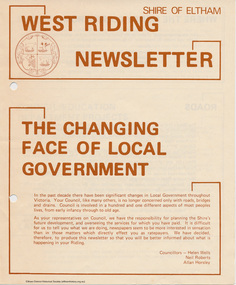
Newspaper - Folder, Shire of Eltham, West Riding Newsletter, 1978
Newsletter produced by the Shire of Eltham including introduction titled: "The changing face of local government", signed by Ward councillors: Helen Wells, Neil Roberts and Allan Horsley, a brief financial statement: "where the money comes from", roads, shopping centres, council/education department projects, land purchase, senior citizens and recreation include list of new construction and upgrades. Folder 71 from Harry Gilham Collection4 pages. Foldedallan horsley, community services, shire of eltham, budget, roads, shoppping centres, briar hill, montmorency, recreation, helen wells, neil roberts -
 Eltham District Historical Society Inc
Photograph, Tom Prior, Doney's Store, Research
A much updated version of the store and house just prior to its removal.The Reynolds family were early settlers in Research. The Reynolds/ Prior collection of photographs were taken by Tom Prior, the maternal uncle of Ivy Reynolds, around 1900 and the 60 photos in the album give a fine overview of many of the landmarks of Research and Eltham over 100 years ago. lvy lived in the family home for many years at 106 Thompson Cres Research. Ivy's father, Ernst Richard Reynolds and grandfather, Richard Reynolds, lived at the same address. Ivy's father Richard worked for Mr. Trail on his property in Research. Reynolds Road is named after the family. Mr Tom Prior (wife Eva) worked at the Melbourne zoo. He was very innovative and made his own camera, using the black cloth hood to exclude the light. The photographs are a reminder of the rural nature of Research and Eltham and its rich heritage. Black and white photograph mounted in an album, the Reynolds/Prior Photograph Collection, this being one of 53 reproduced black and white images of early Eltham.The Reynolds/Prior Photograph Collection, Presented to the Eltham District Historical Society, 14 June 2006 by Ross McDonald. A second copy was also presented to the Andrew Ross Museum, Kangaroo Grounddoney property, eltham south, general store, ingrams road, main road, research (vic.), reynolds prior collection, shops, state route 44 -
 Eltham District Historical Society Inc
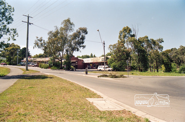
Photograph, Research Shops looking southeast from intersection of Main Road and Research Warrandyte Road, c.1992, 1992c
Roll of 35mm colour negative film, 7 strips Fuji 100main road, research (vic.), research warrandyte road -
 Eltham District Historical Society Inc
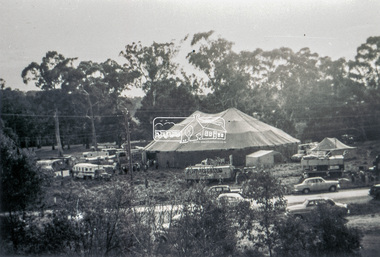
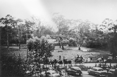
Slide - Photograph, Grace Mitchell, Ashtons Circus set up in Bremner's Reserve, Main Road, Eltham, c.1955
View from Grace Mitchell's shop at the corner of Mount Pleasant Road and Main Road. Grace Mitchell was probably best known for her Eltham shop at the corner of Mt Pleasant Road and Main Road. Grace's memories covered many local identities who were patrons of her shop between 1954 and 1971. From the elevated position of her shop and home Grace was able to view a varied passing parade of Eltham events from ERSILAC, Easter and Eltham Festival parades passing on their way to Eltham Lower Park, circuses in Wingrove Park (then Bremner’s Reserve), roadworks and other happenings. Bremner's Reserve was renamed Wingrove Park c.1970 This photo was from a series of images presented by Grace Mitchell at a Society talk 10 March 1993 on the theme of “My Eltham”.35mm Kodak 5052 TMX Black and White transparency, 1 strip, 6 frames Black and white print 17 x 25.4 cmashtons circus, bremner's flat, circus, grace mitchell, main road, mount pleasant road, wingrove park -
 Eltham District Historical Society Inc
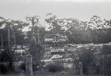
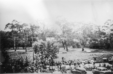
Slide - Photograph, Grace Mitchell, Ashtons Circus set up in Bremner's Reserve, Main Road, Eltham, c.1955
View from Grace Mitchell's shop at the corner of Mount Pleasant Road and Main Road. Grace Mitchell was probably best known for her Eltham shop at the corner of Mt Pleasant Road and Main Road. Grace's memories covered many local identities who were patrons of her shop between 1954 and 1971. From the elevated position of her shop and home Grace was able to view a varied passing parade of Eltham events from ERSILAC, Easter and Eltham Festival parades passing on their way to Eltham Lower Park, circuses in Wingrove Park (then Bremner’s Reserve), roadworks and other happenings. Bremner's Reserve was renamed Wingrove Park c.1970 This photo was from a series of images presented by Grace Mitchell at a Society talk 10 March 1993 on the theme of “My Eltham”.35mm Kodak 5052 TMX Black and White transparency, 1 strip, 6 frames Black and white print 17 x 25.4 cmashtons circus, bremner's flat, circus, grace mitchell, main road, mount pleasant road, wingrove park -
 Eltham District Historical Society Inc
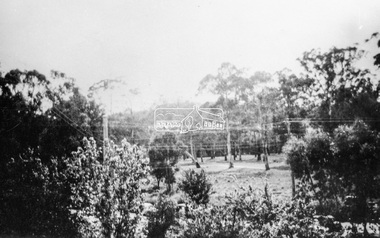
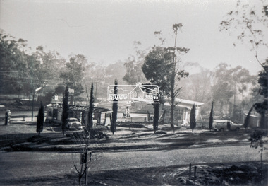
Photograph, Grace Mitchell, Bremners Flat, Main Road, Eltham, 1958c
View from Grace Mitchell's shop at the corner of Mount Pleasant Road and Main Road. Grace Mitchell was probably best known for her Eltham shop at the corner of Mt Pleasant Road and Main Road. Grace's memories covered many local identities who were patrons of her shop between 1954 and 1971. From the elevated position of her shop and home Grace was able to view a varied passing parade of Eltham events from ERSILAC, Easter and Eltham Festival parades passing on their way to Eltham Lower Park, circuses in Wingrove Park (then Bremner’s Reserve), roadworks and other happenings. Bremner's Reserve was renamed Wingrove Park c.1970 This photo was from a series of images presented by Grace Mitchell at a Society talk 10 March 1993 on the theme of “My Eltham”.Black and white print 17 x 25.4 cmbremner's flat, main road, mount pleasant road, wingrove park -
 Eltham District Historical Society Inc
Photograph, Grace Mitchell, Diamond Creek in flood, Bremners Flat, Main Road, Eltham, c.1958
View from Grace Mitchell's shop at the corner of Mount Pleasant Road and Main Road. Grace Mitchell was probably best known for her Eltham shop at the corner of Mt Pleasant Road and Main Road. Grace's memories covered many local identities who were patrons of her shop between 1954 and 1971. From the elevated position of her shop and home Grace was able to view a varied passing parade of Eltham events from ERSILAC, Easter and Eltham Festival parades passing on their way to Eltham Lower Park, circuses in Wingrove Park (then Bremner’s Reserve), roadworks and other happenings. Bremner's Reserve was renamed Wingrove Park c.1970 This photo was from a series of images presented by Grace Mitchell at a Society talk 10 March 1993 on the theme of “My Eltham”.Black and white print 17 x 25.4 cmbremner's flat, diamond creek, floods, main road, mount pleasant road, wingrove park -
 Eltham District Historical Society Inc
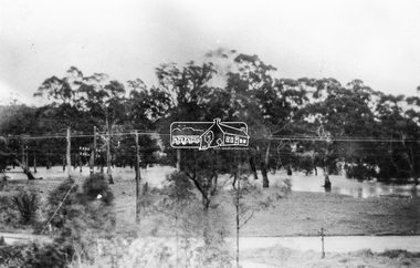
Slide - Photograph, Grace Mitchell, Portable buildings on trucks possibly for installation at the Golden Fleece Service Station, corner of Main Road and Mount Pleasant Road, Eltham, c.1961
View from Grace Mitchell's shop at the corner of Mount Pleasant Road and Main Road. Grace Mitchell was probably best known for her Eltham shop at the corner of Mt Pleasant Road and Main Road. Grace's memories covered many local identities who were patrons of her shop between 1954 and 1971. From the elevated position of her shop and home Grace was able to view a varied passing parade of Eltham events from ERSILAC, Easter and Eltham Festival parades passing on their way to Eltham Lower Park, circuses in Wingrove Park (then Bremner’s Reserve), roadworks and other happenings. Bremner's Reserve was renamed Wingrove Park c.1970 This photo was from a series of images presented by Grace Mitchell at a Society talk 10 March 1993 on the theme of “My Eltham”.35mm Kodak 5052 TMX Black and White transparency, 1 strip, 6 frames Black and white print 17 x 25.4 cmgolden fleece service station, main road, mount pleasant road -
 Eltham District Historical Society Inc
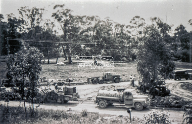
Slide - Photograph, Grace Mitchell, Roadworks at intersection of Main Road and Mount Pleasant Road, Eltham, c.1962
View from Grace Mitchell's shop at the corner of Mount Pleasant Road and Main Road. Grace Mitchell was probably best known for her Eltham shop at the corner of Mt Pleasant Road and Main Road. Grace's memories covered many local identities who were patrons of her shop between 1954 and 1971. From the elevated position of her shop and home Grace was able to view a varied passing parade of Eltham events from ERSILAC, Easter and Eltham Festival parades passing on their way to Eltham Lower Park, circuses in Wingrove Park (then Bremner’s Reserve), roadworks and other happenings. Bremner's Reserve was renamed Wingrove Park c.1970 35mm Kodak 5052 TMX Black and White transparency, 1 strip, 6 frames Black and white print 17 x 25.4 cmbremner's flat, eltham, golden fleece service station, main road, mount pleasant road, road construction, wingrove park -
 Eltham District Historical Society Inc
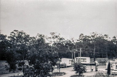
Slide - Photograph, Grace Mitchell, Golden Fleece Service Station at the corner of Main Road and Mount Pleasant Road, Eltham, c.1961
View from Grace Mitchell's shop at the corner of Mount Pleasant Road and Main Road. Grace Mitchell was probably best known for her Eltham shop at the corner of Mt Pleasant Road and Main Road. Grace's memories covered many local identities who were patrons of her shop between 1954 and 1971. From the elevated position of her shop and home Grace was able to view a varied passing parade of Eltham events from ERSILAC, Easter and Eltham Festival parades passing on their way to Eltham Lower Park, circuses in Wingrove Park (then Bremner’s Reserve), roadworks and other happenings. Bremner's Reserve was renamed Wingrove Park c.1970 This photo was from a series of images presented by Grace Mitchell at a Society talk 10 March 1993 on the theme of “My Eltham”. The Holden wagon appears to be an FB or EK model with finned rear taillights. The FB was produced January 1960-May 1961 and the EK May 1961 to July 196235mm Kodak 5052 TMX Black and White transparency, 1 strip, 6 frames Black and white print 17 x 25.4 cmgolden fleece service station, main road, mount pleasant road -
 Eltham District Historical Society Inc
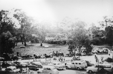
Photograph, Grace Mitchell, Possibly the Ersilac Parade travelling along Main Road, Eltham, c.1958
View from Grace Mitchell's shop at the corner of Mount Pleasant Road and Main Road. Grace Mitchell was probably best known for her Eltham shop at the corner of Mt Pleasant Road and Main Road. Grace's memories covered many local identities who were patrons of her shop between 1954 and 1971. From the elevated position of her shop and home Grace was able to view a varied passing parade of Eltham events from ERSILAC, Easter and Eltham Festival parades passing on their way to Eltham Lower Park, circuses in Wingrove Park (then Bremner’s Reserve), roadworks and other happenings. Bremner's Reserve was renamed Wingrove Park c.1970 This photo was from a series of images presented by Grace Mitchell at a Society talk 10 March 1993 on the theme of “My Eltham”.Black and white print 17 x 25.4 cmcars, bremner's flat, eltham, ersilac parade, main road, mount pleasant road, wingrove park, festival, horse drawn carriage -
 Eltham District Historical Society Inc
Photograph, Grace Mitchell, Possibly the Ersilac Parade travelling along Main Road, Eltham, 1958c
View from Grace Mitchell's shop at the corner of Mount Pleasant Road and Main Road. Grace Mitchell was probably best known for her Eltham shop at the corner of Mt Pleasant Road and Main Road. Grace's memories covered many local identities who were patrons of her shop between 1954 and 1971. From the elevated position of her shop and home Grace was able to view a varied passing parade of Eltham events from ERSILAC, Easter and Eltham Festival parades passing on their way to Eltham Lower Park, circuses in Wingrove Park (then Bremner’s Reserve), roadworks and other happenings. Bremner's Reserve was renamed Wingrove Park c.1970 This photo was from a series of images presented by Grace Mitchell at a Society talk 10 March 1993 on the theme of “My Eltham”.Black and white print 17 x 25.4 cmcars, bremner's flat, eltham, ersilac parade, main road, mount pleasant road, wingrove park, festival, horse drawn carriage -
 Eltham District Historical Society Inc
Photograph, Grace Mitchell, Possibly the Ersilac Parade travelling along Main Road, Eltham, c.1958
View from Grace Mitchell's shop at the corner of Mount Pleasant Road and Main Road. Grace Mitchell was probably best known for her Eltham shop at the corner of Mt Pleasant Road and Main Road. Grace's memories covered many local identities who were patrons of her shop between 1954 and 1971. From the elevated position of her shop and home Grace was able to view a varied passing parade of Eltham events from ERSILAC, Easter and Eltham Festival parades passing on their way to Eltham Lower Park, circuses in Wingrove Park (then Bremner’s Reserve), roadworks and other happenings. Bremner's Reserve was renamed Wingrove Park c.1970 This photo was from a series of images presented by Grace Mitchell at a Society talk 10 March 1993 on the theme of “My Eltham”.Black and white print 17 x 25.4 cmcars, bremner's flat, eltham, ersilac parade, main road, mount pleasant road, wingrove park, festival, horse drawn carriage -
 Eltham District Historical Society Inc
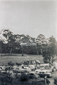
Slide - Photograph, Possibly the Ersilac Parade travelling along Main Road, Eltham, c.1958
View from Grace Mitchell's shop at the corner of Mount Pleasant Road and Main Road. Grace Mitchell was probably best known for her Eltham shop at the corner of Mt Pleasant Road and Main Road. Grace's memories covered many local identities who were patrons of her shop between 1954 and 1971. From the elevated position of her shop and home Grace was able to view a varied passing parade of Eltham events from ERSILAC, Easter and Eltham Festival parades passing on their way to Eltham Lower Park, circuses in Wingrove Park (then Bremner’s Reserve), roadworks and other happenings. Bremner's Reserve was renamed Wingrove Park c.1970 This photo was from a series of images presented by Grace Mitchell at a Society talk 10 March 1993 on the theme of “My Eltham”. Alistair Knox had one of the first VW Beetles in Eltham; perhaps the one shown is his. This model has a large rear window, first introduced in 1958. The Holden ute could be an FC or FE. The FE was produced July 1956-April 1958 and the FC May 1958-January 196035mm Kodak 5052 TMX Black and White transparency, 1 strip, 6 frames Black and white print 17 x 25.4 cmcars, bremner's flat, eltham, ersilac parade, main road, mount pleasant road, wingrove park, festival, horse drawn carriage -
 Eltham District Historical Society Inc
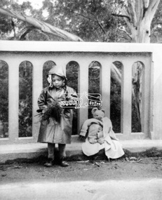
Photograph, Grace Mitchell, A young Jenni Mitchell with flowers and teddy bear on Main Road Bridge, Eltham, 1958c
Grace Mitchell was probably best known for her Eltham shop at the corner of Mt Pleasant Road and Main Road. Grace's memories covered many local identities who were patrons of her shop between 1954 and 1971. From the elevated position of her shop and home Grace was able to view a varied passing parade of Eltham events from ERSILAC, Easter and Eltham Festival parades passing on their way to Eltham Lower Park, circuses in Wingrove Park (then Bremner’s Reserve), roadworks and other happenings. Bremner's Reserve was renamed Wingrove Park c.1970 This photo of her daughter Jenni was from a series of images presented by Grace Mitchell at a Society talk 10 March 1993 on the theme of “My Eltham”. Jenni Mitchell was born 1955 according to Australian Art Sales Digest and grew up to become a noted local Eltham artist and one time Councillor.Black and white print 17 x 25.4 cmjenni mitchell, main road bridge, eltham -
 Eltham District Historical Society Inc
Document - Folder, Eltham Community Festival, 1986
1. Letter from the Secretary of Shire of Eltham Historical Society to Ben Hall of Tullamarine, 11 August 1986 - Enquiry (11 Aug 1986) as to whether Ben Hall would be interested in partnering with the Society in the 1986 Eltham Festival (8-9 November) to participate in the parade and then offer rides after the parade to recover costs of entry. 2. Copy of letter (8 Apr 1987) offering payment in recognition of Ben Hall's efforts for the parade in 1986 3. Eltham's festival celebrates International Year of Peace, Diamond Valley News, Tuesday, October 14, 1986 (on reverse, advertising for opening of The Photo Centre at Shop 11, Eltham Mall, Arthur Street) 4. Firewaorks brilliant, Diamond Valley News, Tuesday, November 11, 1986, p12Letter A4 x 21986, ben hall, eltham festival, eltham town park, parade, phyllis macdonald, russell yeoman, 11 bridge street eltham, advertising, banner project, eltham clubs, eltham combined service clubs, eltham community centre, eltham community festival, eltham hotel, eltham police, eltham pre-school, lions club eltham, pine connection, plenty valley montessori school, research football club, research oval, research pre-school, research primary school, research scout group, sgt arthur traynor, shire of eltham banner project, shire of eltham historical society, 953 main road eltham, wattle studios -
 Eltham District Historical Society Inc
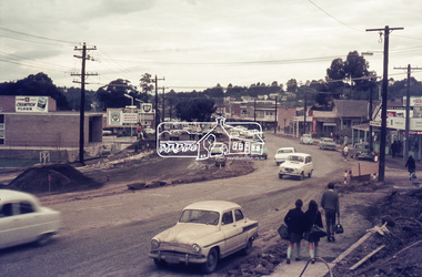
Photograph, Looking north along Main Road at Dudley Street, Eltham, c.February 1968, 1968
... Street, Dudley Street, duplication, Eltham, Main Road, shopping ...Immediately prior to duplication of Main Road35mm Colour positive transparency Mount - Agfacolor Service (Blue stepped)arthur street, dudley street, duplication, eltham, main road, shopping centre -
 Eltham District Historical Society Inc
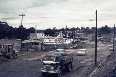
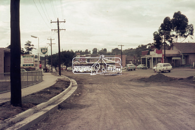
Photograph, Roadworks, Main Road widening, Eltham, 15 July 1968, 1968
Looking north from near Dudley Street towards shopping strip35mm Colour positive transparency Mount - Agfacolor Service (Blue stepped)arthur street, bp service station, dudley street, duplication, eltham, eltham fire brigade, eltham war memorial, fire station, main road, road construction, war memorial gates -
 Eltham District Historical Society Inc
Photograph, Roadworks, Main Road widening, Eltham, 15 July 1968, 1968
Looking north from near Dudley Street towards shopping strip35mm Colour positive transparency Mount - Agfacolor Service (Blue stepped)bp service station, duplication, eltham, eltham fire brigade, fire station, main road, road construction -
 Eltham District Historical Society Inc
Photograph, Roadworks, Main Road widening, Eltham, c.15 July 1968, 1968
Looking north from near Dudley Street towards shopping strip35mm Colour positive transparency Mount - Agfacolor Service (Blue stepped)arthur street, bp service station, duplication, eltham, eltham fire brigade, fire station, main road, road construction