Showing 8398 items matching "mckillops-bridge"
-
 Wheen Bee Foundation
Publication, Brother Adam, In search of the best strains of bees (Brother Adam), Hebden Bridge, 1983, 1983
-
 Beechworth Honey Archive
Publication, Collecting bee books: beekeeping in a nutshell (Kinross, J.), Hebden Bridge
-
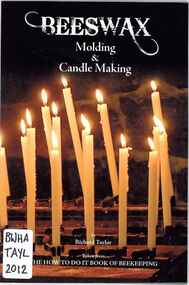 Beechworth Honey Archive
Publication, Beeswax: moulding & candle making (Taylor, R.), Hebden Bridge, 2012, 2012
-
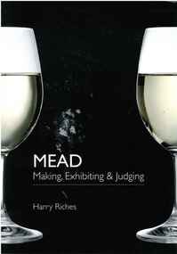 Beechworth Honey Archive
Publication, Mead: making, exhibiting and judging. (Riches, Harry R. C.). Hedben Bridge UK, 2009, 2009
80 pages, illustrated -
 Beechworth Honey Archive
Publication, Pollen identification for beekeepers. (Sawyer, Rex and Pickard, R. S. (editor)). Hebden Bridge, UK, 2006, 2006
111 pages, illustrated. -
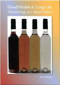 Beechworth Honey Archive
Publication, Good health & long life: meanderings of a mead maker. (Dennis, Brian P.). Hebden Bridge, UK, 2011, 2011
38 pages, illustrated. -
 Glenelg Shire Council Cultural Collection
Document - Engineering report - typed, 10/02/1964
Five foolscap pages with typed information and photographs, Dartmoor Hamilton Road, Bridge over Humphy's Creek. Stapled top left, signed by E.J.E. Byrne, Bridge Inspecting Engineer.engineering, professional report, bridge, building works, dartmoor -
 Linton and District Historical Society Inc
Photograph, Dilapidated bridge over Springdallah Creek, Happy Valley/Piggoreet, 2010
This bridge was built in the 1880s. By the 1980s it was in a dilapidated condition and was replaced. The old bridge was further damaged by storms and flooding in November 2010 and January 2011. (The newer bridge was completely washed away when the Springdallah Creek flooded in January 2011.) In 2025, little remains of the old bridge.Two colour photographs of a trestle bridge spanning Springdallah Creek, Linton-Piggoreet Road. The two photographs have been sticky-taped together to form one panoramic image.trestle bridges, old springdallah bridge -
 Federation University Historical Collection
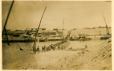
Postcard, Crossing the Suez via Pontoon Bridge, 1915
During WWI some AIF soldiers were located at the Suez in Egypt.Postcard with sepia photograph of Suez canal with soldiers crossing a pontoon bridge.Verso: "POST CARD" at centre top, "Correspondence" LHS top and "Address" RHS top "No 2" in black ink handwritten on top LHS corner. Handwriting blacked out on centre. "crossing the Suez via Pontoon Bridge" in pencilsuez, soldiers, wwi, world war one, canal, pontoon bridge, holmes, anzac -
 Phillip Island and District Historical Society Inc.
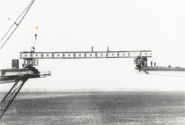
Photograph, Phillip Island Bridge, 1968/9
1969 Phillip Island Bridge under construction. From the Jack Jenner Collection.Joining Girder between two sides of new Bridge. Part of crane shown. Men on the girder and each side.local history, photographs, civil engineering, bridges, phillip island bridge under construction, black & white photograph, jack jenner collection, phillip island bridges, public construction -
 Ballarat Heritage Services
Photograph - Photograph - Colour, The Edna Walling Bridge at Locarno Spring in the Hepburn Springs Reserve, 2020, 12/12/2020
The Hepburn Springs Progress Association invited Edna Walling the the Hepburn Springs Reserve, and sandstone paths and bridges resulted. In 1934 there was a proposal to spend 2,000 to 3,000 poinds at the Hepburn Springs Reserve, with a govenrment loan suggested. Colour photograph of the stone bridge at Locarno Spring in the Hepburn Springs Reserve.hepburn springs, locarno, mineral water, hepburn springs reserve, locarno spring, edna walling -
 Federation University Historical Collection
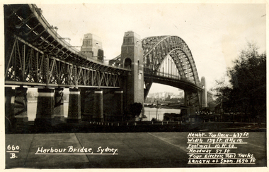
Postcard, Kodak, Sydney Harbour Bridge, c1949, 13/10/1949
Postcard written by Frank Wright to a friend, W. Snelling in London. Frank Wright was a renown resident of Smeaton, where he was born. He lived at Laura Villa, and attended Smeaton State School. His father William was a gold miner and his mother's name was Sarah. Their family won many singing and instrumental awards. Frank was tutored by Percy Code and was awarded a gold medal for the highest marks in the ALCM examinations in the British Colonies at the age of seventeen years. He became the Australian Open Cornet Champion by the age of eighteen. A year later, Frank conducted the City of Ballarat Band, and later the Ballarat Soldiers’ Memorial Band. He formed the Frank Wright Frisco Band and Frank Wright and his Coliseum Orchestra. These bands won many South Street awards, and Frank as conductor won many awards in the Australian Band Championship contest. In 1933 Frank Wright sailed to England to conduct the famous St Hilda’s Band and was later appointed Musical Director of the London County Council, where he organized many amazing concerts in parks, in and around the London district. He was made Professor of Brass and Military Band Scoring and conducted at the Guildhall of Music and Drama. Frank was often invited to adjudicate Brass Band Championships around Europe, in Australia, including South Street and in New Zealand. The Frank Wright Medal at the Royal South Street competition is awarded to an individual recognized as making an outstanding contribution to brass music in Australia.Black and white photograph of the Sydney Harbour Bridge. A small section of the city and water can be seen beneath the arched span of the bridge.Written in white on front - 660.B, Harbour Bridge, Sydney., Height-Top arch - 437 ft.,Width 159 ft. 11 3/4 in., Footways 10 ft. ea., Roadway 57 ft., Four Electric Rail Tracks., Length of span 1650 ft. Handwritten on back - Message to W. Snelling in London from Frank Wrightfrank wright, cornet, conductor, sydney harbour bridge -
 Phillip Island and District Historical Society Inc.
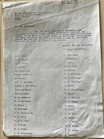
Document, Petition for bridge between Phillip Island and San Remo 1937
On 29 November 1940, a suspension bridge opened between San Remo on the mainland and with Newhaven on Phillip Island. The 540 metre bridge had two lanes but no footpaths, instead having six pedestrian refuges. The main span was 168 metres long. The cables had previously been used on a bridge on Sydney's North Shore. Because of weight restrictions, tourist coaches had to offload their passengers. [Wikipedia]HistoricalFoolscap size photocopy of a petition to Shire of Phillip Island for a bridge to Phillip Island in 1937. Signed by 42 local residents and ratepayers.first phillip island bridge to san remo, phillip island suspension bridge, petition, odlum, ockleford, regos, mcguigan, west, mcfee, richardson, underdown, mcmaster, cleeland, neely, leeson, saunders, scott, brown, hislop, donnellan, rackham, findlay, anderson -
 Orbost & District Historical Society
black and white photograph, July 1922
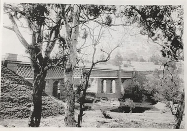
A new bridge over the Snowy River at Orbost was opened for traffic on June 20th 1922. It was designed for future joint use by road and railway traffic, but it was only used for road traffic. During the last few years the condition of an old suspension bridge [the 1893 bridge] which was the only vehicular crossing between the town of Orbost and the railway station, caused much concern. The structure was of timber, except for the wire suspension cables of its central span of about 100 feet. A design was prepared in 1914 for a permanent bridge with five spans of 85 feet composed of plate girders on concrete piers. With great increase in the price of steel work during the war, the cost of this design became prohibitive, and the need for a new structure becoming urgent, alternative proposals were investigated. As a result the present design was adopted as providing a sem-permanent bridge at moderate cost. The new bridge spans the river about 160 feet upstream from the old bridge on a slight skew, the piers being at an angle of 80 degrees with the centre line of the bridge. It has a camber of about 2 feet 5 inches in its total length of 527 feet. ( information from Newsletter March 2014 - Lois Crisp) The photograph shows Mrs James Cameron cutting the ribbon at the opening of the Orbost Pile Bridge in 1922. This second bridge, was built by the Victorian Railways and the Country Roads Board. Constructed at a cost of 35,000 pounds and used second-hand girders from the Flinders Street- Spencer Street viaduct. On July 4 1922 it was officially opened by Mrs James Cameron. Unfortunately, her husband, who had long championed the building of the bridge so that it would be ready for the railway to continue to the border, was too ill to attend the ceremony. In fact, James Cameron died on July 13 after a long and severe illness (ref. S.R.M. 20.7.1922). There is a section of this ribbon in the collection - Registration No. 366. This is a pictorial record of a significant event in Orbost's history.A black / white photograph of a pile bridge with a suspension bridge behind it. There are many people standing on the bridge.on back - "Opening of Pile Bridge - 1922"snowy-river-bridge ceremonies cameron-mrs -
Hume City Civic Collection
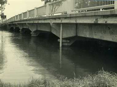
Photograph, Macedon Street Bridge, 1986
The photograph was taken showing the underside of the Macedon Street Bridge which spans the Jacksons Creek. It was constructed in the second half of the 1800s and replaced a pontoon that was used for river crossings.This is one of the five historic bridges which have been constructed in Sunbury.A non- digital black and white photograph of two arched bluestone bridge spanning a watercourse.macedon street bridge, bridges, jacksons creek -
 Charlton Golden Grains Museum Inc
Photograph, Cameron, Ian, 1973 February Flood, Feb 1973
1973 flood. High water depth under Paterson Bridge, Charlton Victoria,B/W photograph of 1973 flood. High water depth under Paterson Bridge.flood, james paterson bridge, charlton -
 Phillip Island and District Historical Society Inc.
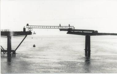
Photograph, Suspension Bridge, 1939-1940
Phillip Island's first Bridge for vehicular traffic under construction. Phillip Island Suspension Bridge under construction - angled view taken from San Remo with small boat at middle leftlocal history, photographs, civil engineering, bridges, phillip island - suspension bridge, black & white photograph, jack jenner collection, phillip island bridges, public construction -
 St Arnaud and District Historical Society
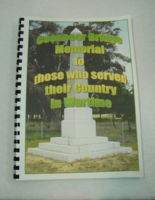
Book. Coonooer Bridge Memorial, Coonooer Bridge Memorial to those who served their Country in Wartime
Following the Great War of 1914-18 the people who lived in the general area around Coonooer Bridge , (18 kms from St.Arnaud ) erected a Monument in honour of those men and women who served their country in a time of war. In 1920 the monument was erected across from the hall, situated in a small pine plantation which was also planted by community members. The names of those that served their country during war time were placed on the monument. After the 2nd World War the names of the local men and women who once again were asked to serve their country were added to the memorial to honour and remember the sacrifice that they made.This book was compiled to honour and enable families and future generations to remember those who served.This is the only book listing these servicemen that served from the Coonooer Bridge Area.Spiral plastic bound book.Clear perspex cover. Coloured pages.Includes photographs of servicemen, medals and war service information.Dedicated to the people of Coonooer Bridge. -
 Kew Historical Society Inc
Photograph, Chandler Highway Bridge, 1930s
The railway viaduct linking the Outer Circle railway from Kew to Fairfield was constructed in the 1890s. In the 1930s it was converted into a motorway bridge.Photocopy of a photograph of the bridge linking Kew and Fairfield. Dated to the 1930s following the construction off the Chanler Highway.outer circle railway, viaduct (kew fairfield), john monash, chandler highway bridge -
 Mt Dandenong & District Historical Society Inc.
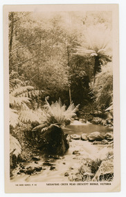
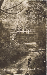
Photograph, Sassafras Creek Near Crescent Bridge. Victoria
Rose Series post card # P. 90. Sassafras Creek near The Crescent Bridge. View of water and ferns. Post 1920.Rose Series sepia coloured post card showing a small creek running through the centre of the photo edged by rocks and tree ferns.On front: The Rose Series, P. 90. SASSAFRAS CREEK NEAR CRESCENT BRIDGE. VICTORIA.sassafras creek, crescent bridge, creek, bridge, tree ferns, rose series, post card -
 Phillip Island and District Historical Society Inc.
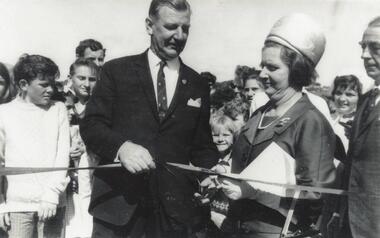
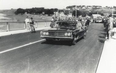
Photograph, Phillip Island Bridge Opening, 1969
Official Opening of 2nd Bridge, 1969, connecting San Remo and Newhaven. From the Jack Jenner Collection.Close up of Hon. Porter & Mrs Porter cutting ribbon at Opening of Bridge. Children & other spectators in background.local history, photographs, civil engineering, bridges, opening of phillip island bridge, black & white photograph, jack jenner collection, phillip island bridges, public construction -
 Marysville & District Historical Society
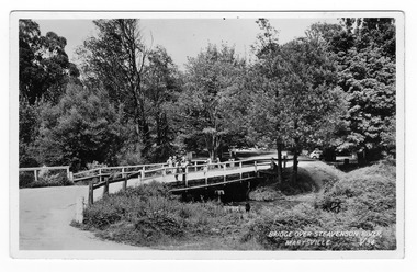
Postcard (Item) - Black and white postcard, Valentine Publishing Co. Pty. Ltd, BRIDGE OVER STEAVENSON RIVER, MARYSVILLE. V.34, 1923-1963
A black and white photograph of a bridge over the Steavenson River in Marysville in Victoria.A black and white photograph of a bridge over the Steavenson River in Marysville in Victoria. The Steavenson River is named after the Victorian Assistant Commissioner of Roads and Bridges, John Steavenson who arrived in Victoria in the early 1860s. This postcard was produced by Valentine Publishing Co Pty. Ltd. as a souvenir of Marysville.VALENTINE'S POST CARD A GENUINE PHOTOGRAPH 1940marysville, victoria, steavenson river, valentine publishing co, postcard, souvenir, john steavenson -
 Chelsea & District Historical Society Inc
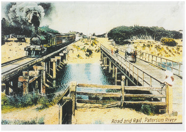
Photograph - Patterson River Postcards, Rail and Road Bridge, c 1905
The first bridge over the river was built in the early 1880's, prior to this it was a pontoon bridge. Dr. Sheldon's Magnetic Liniment was advertised as being able to relieve "at once rheumatism, lumbago, lame back, cuts, bruises or burns, will effect a cure in a remarkably short time. Price 1s 6d and 3s"Two postcards of the road bridge (Nepean Highway) with a horse and cart and people crossing and single line rail bridge , with a steam train crossing over Patterson River, near the mouth of the river. One card has been coloured, the other has been modified to advertise Dr Sheldon's Magnetic Liniment.DR SHELDON'S NEW DISCOVERY 16' & 3' BANISHES ALL PAINS AT CARRUM VICTORIApatterson river, road bridge, rail bridge, dr sheldon's linament, chelsea, steam train, transport, chelsea bridge, patterson bridge -
 Wodonga & District Historical Society Inc
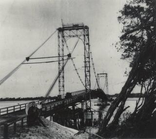
Photograph - Bethanga Bridge
The Bethanga Bridge was built between 1927 and 1930 as a joint venture between Victoria and New South Wales and was a key element of the River Murray Waters Agreement. It consists of nine spans of 82 metres long. Each span is supported between double reinforced concrete pylons and a riveted steel camel back Pratt truss. The overall span of the bridge is a length of 752 metres. It was completed in 1929 at a cost of £194,000. The road deck was initially constructed from timber but was replaced in 1961 with a concrete waffle slab deck 7.7metres wide. In 1961 the bridge deck and truss structure were raised 300 millimetres to allow for the enlargement of the lake. The bridge was designed in NSW by road engineer Percy Alan and the trusses were built by the Charles Ruwolt Pty. Ltd. Charles Ruwolt Pty. Ltd. was originally established by Charles Ruwolt as a foundry at Wangaratta in 1902 and transferred its operations to Richmond, Melbourne in 1914. By 1938 it had become one of the biggest engineering companies in Australia. After Charles Ruwolt’s death in 1946, Vickers Ltd. acquired the company and in 1948 the firm became known as Vickers Ruwolt Pty. Ltd. Because of the Bethanga Bridge’s unique location, over the waters of a dam with the border running down the centre of the body of water, the Bethanga Bridge is the only built structure shared by both Victoria and New South Wales. As the border of New South Wales aligns with the southern bank of the Murray River all of the other bridges along its length are deemed to be in New South Wales. The Bethanga Bridge is listed on both the New South Wales State Heritage Register and the Victorian Heritage Database. In 2015 the Bethanga Bridge was nominated for a heritage award by the Institution of Engineering Australia.These images are significant because they document the construction of a bridge which links Victoria and New South Wales and has been recognised for its historical, technical and engineering significance.A collection of photos documenting the construction of the Bethanga Bridge which links the States of Victoria and New South Wales as part of the construction of the Hume Dam .bethanga bridge, hume dam constuction, charles ruwolt, percy allan engineer -
 Cockatoo History & Heritage Group
Postcard, Barratt Photo of Men on McBride St Bridge Cockatoo
An early Barratt photo of the Cockatoo Creek, looking towards the McBride St bridge. The four men depicted in the image, look relaxed and are taking in the serenity of the creek below.Dear Florrie, just a card to let you know I haven't quite ? altogether am up here among the ferns and ? It is a lovely place for a quiet holiday the fern gullys are just lovely you can see the Ranges in the distance as blue as the sea. This view is the bridge over Cockatoo creek near the R. Station. As space is short I will close Best Love from ?Original Barratt Photo, of four men standing on the McBride St bridge over the Cockatoo CreekRear of the postcard includes handwritten correspondence in ink, to someone called Florriea. t barratt, postcard, cockatoo creek, cockatoo, views of cockatoo, -
 Phillip Island and District Historical Society Inc.
Photograph, Suspension Bridge, 1939-40
Phillip Island Suspension Bridge under construction - completed in 1940Phillip Island Suspension Bridge taken from shore on angle - Phillip Island side - trees pushed onto right hand side.local history, photographs, civil engineering, bridges, phillip island suspension bridge, black & white photograph, jack jenner collection, phillip island bridges -
 Phillip Island and District Historical Society Inc.
Photograph, Phillip Island Bridge Opening, 1969
First traffic across 2nd Bridge, 1969, between Sand Remo & Newhaven, after official opening ceremony. From the Jack Jenner Collection.Minister's Car driving across newly opened Bridge between San Remo & Phillip Island 1969.local history, photographs, civil engineering, bridges, opening of phillip island bridge, black & white photograph, jack jenner collection, phillip island bridges, public construction -
 Marysville & District Historical Society
Photograph (Item) - Black and white photograph, Bridge Over The Cumberland, c1900
An early black and white photograph of a bridge over the Cumberland Creek near Marysville in Victoria.An early black and white photograph of a bridge over the Cumberland Creek near Marysville in Victoria. The Cumberland Creek is in the Cumberland Valley near Cambarville which was a timber town near Marysville. Cambarville is notable for its giant mountain ash (Eucalyptus regnans) trees within the Cumberland Memorial Scenic Reserve, and relics from former sawmills and gold mining. The Big Culvert is located nearby on the Marysville - Woods Point Road, which was historically part of the Yarra Track. Cambarville was established as a timber mill town in the 1940s. Timber mill owners A Cameron and FJ Barton named Cambarville. They established the mill to salvage timber from trees destroyed in the 1939 bushfires. Cambarville was impacted by the 2009 Black Saturday bushfires and any remaining structures were destroyed.ARMSTRONG COLLECTION 42 STATION STREET/ SANDRINGHAM 3191/ TEL. (03) 9521 5442/ IAN M.L. ARMSTRONG OAMcumberland creek, marysville, victoria, cumberland valley, cambarville, mountain ash, eucalyptus regnans, cumberland memorial reserve, the big culvert, marysville-wood's point road, yarra track, a cameron, fj barton, 2009 black saturday bushfires -
 Stawell Historical Society Inc
Book, P. Van Diesen, Tobacco Growing in Dadswells Bridge, 1991
History Option H.3.C. Tobacco Industry at Dadwells Bridge Contains various photographs.Clear Plastic cover with dark blue edge. on Plastic History Option P. Van Diesen. On Paper underneath cover Tobacco Growing in Dadswell Bridgestawell farming