Showing 345 items matching "mining geology"
-
 Bendigo Historical Society Inc.
Book - 'BULLETINS OF THE GEOLOGICAL SURVEY OF VICTORIA NO. 30'. THE PEARL AND HERCULES AND ENERGETIC MINES, BENDIGO, 1914
Bulletins of the Geological Survey of Victoria No. 30. The Pearl and Hercules and Energetic Mines, Bendigo, with plans and sections. By W. Baraganath Underground maps of the 4 (four) mines referred to in this book. Priced six pence Inscribed on the front cover: A. Richardson, 29 Harrison Street, Bendigo.Department of Mines. By W. Baraganathbendigo, mining, early history., mining, pearl, hercules and energetic mines. -
 Bendigo Historical Society Inc.
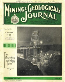
Book - MINING & GEOLOGICAL JOURNAL. VOL 1, NO.4, 1939
... Bendigo. Book MINING & GEOLOGICAL JOURNAL. VOL 1, NO.4. ...Mining & Gelogical Journal Vol.1, No.4. January 1939 published by the Department of Mines Government of Victoria, 72 pages with photographs, illustrations, maps & advertisements. Articles on mining including some Bendigo & district mines.Name on cover A.Richardson 29 Harrison St Bendigo.Department of Mines Victoria.magazine, organization, mining, mining - mines - mining equipment, bendigo mines.central nell gwynne. -
 Bendigo Historical Society Inc.
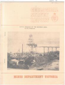
Document - CAROL HOLSWORTH COLLECTION: 1977 GEOLOGY OF THE BENDIGO AREA
... BENDIGO Mining geological survey report Sixteen page booklet ...Sixteen page booklet Geological Survey Report, Mines Department Victoria. 'Geology of the Bendigo Area' by H.E. Wilkinson. Photo of Lansell's 222 Mine on the New Chum Line, Bendigo. Tallest poppet head on the field, approximately 38 m high, with a shaft depth of 635 m.bendigo, mining, geological survey report -
 Bendigo Historical Society Inc.
Document - CAROL HOLSWORTH COLLECTION: GEOLOGICAL REPORT BENDIGO GOLDFIELD BULLETIN 43
... BENDIGO Mining geological bulletin Four page document Geological ...Four page document Geological Report Bendigo Goldfield, C.E. Willman and H.E. Wilkinson. Contents include: folds, cleavage, lineations, lineated quartz in laminated veins, faults, major and minor faults, joints, structural domains and relationship to mineralization.bendigo, mining, geological bulletin -
 Bendigo Historical Society Inc.
Document - CAROL HOLSWORTH COLLECTION: GEOLOGICAL REPORT BENDIGO
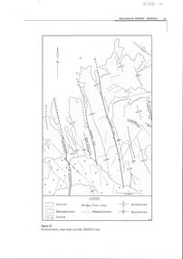
... BENDIGO Mining geological bulletin Four page document ...Four page document, not sequential. Front page: structural trends, major faults and folds in the Bendigo area are depicted in a diagram. Fault lines and folds include the Leichardt Fault, the Break O'Day Fault, Sebastian Fault, Whitelaw Fault, the Yankee Creek Fault and the Fosterville Fault. Aecond page shows the typical reef forms on the Bendigo goldfield (Willman 1988) in a diagram. The Sebastian goldfield is described, with its four lines of reef, the Eureka, Gaskill's, Frederick the Great and Gamboni. Third page describes the White Hills gravels. Fourth page is a table showing thel biostratigraphic zonation of the Ordovician bedrock based on key graptolite forms and assemblages.bendigo, mining, geological bulletin -
 Bendigo Historical Society Inc.
Document - CAROL HOLSWORTH COLLECTION: GEOLOGICAL REPORT BENDIGO GOLDFIELD
... BENDIGO Mining geological bulletin 93 Four page document ...Four page document, an extract from the Geological Report on the Bendigo Goldfield. On front page, a line drawing of a puddling machine. Contents include: alluvial mining, reef mining, the boom years, deep sinking, decline of mining, modern exploration, physiography, the hills, the valleys and the soils. A table demonstrates the development of graptolite structures, including the Lancefieldian, Bendigonian, Chewtonian and Castlemainian graptolite species. Two diagrams demonstrate saddle and bedded reefs and fault reefs. Written on top of the document: C.E. William and H.E. Wilkinson, 1992. Geological Survey Report No. 93.bendigo, mining, geological bulletin 93 -
 Bendigo Historical Society Inc.
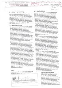
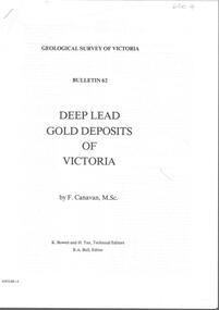
Document - CAROL HOLSWORTH COLLECTION: DEEP LEAD GOLD DEPOSITS OF VICTORIA
... BENDIGO Mining geological survey bulletin 62 Bendigo Sebastian ...Bulletin 62 from the Geological Survey of Victoria, titled ' Derep Lead Gold Deposits of Victoria' by F. Canavan, M Sc. K. Bowen and H. Tan, Technical Editors, R.A. Bull, Editor. Bendigo and Sebastian District and the Huntly Telegraph Lead, are discussed in the paper.bendigo, mining, geological survey bulletin 62, bendigo, sebastian, geological survey. -
Bendigo Historical Society Inc.
Map - MAP: VIRGINIA MINE GARDEN GULLY LINE OF REEF
Map of Virginia Mine on the Garden Gully line of reef, Eaglehawk, transverse section. Shaft, levels and Garden Gully anticlinal axial line drawn. Key shows types of formations - quartz, spurs, sandstone, slate, cleavage, lava. This map forms part of the Geological Survey of Victoria, Structure of Bendigo Goldfield report, No. 47, 1923. H.Herman, late Director of Geological Survey.Geological Survey Victoria, Geological Survey Office, Bendigo.bendigo, gold mining, virgina mine eaglehawk, eaglehawk, bendigo, gold mining, virginia mine, garden gully line of reef. -
Bendigo Historical Society Inc.
Map - BENDIGO GOLD FIELD LONGITUDINAL VERTICAL PROJECTIONS
... mining reef lines mining companies geological survey Geological ...Bendigo gold field map showing vertical projections of portions of three anticlinal axial planes showing stratigraphical zones and caps of known saddle reefs. This map forms part of the Geological Survey of Victoria, Structure of Bendigo Goldfield report, No. 47, 1923. H.Herman, late Director of Geological Survey.Geological Survey Victoriabendigo, gold mining, vertical projections, bendigo, goldfield, gold mining, reef lines, mining companies, geological survey -
 Bendigo Historical Society Inc.
Document - TAMBOUR MAJOR MINE
Six page document describing resources found in a search for 'Tambour major' and 'Mine' with Informit databaxse, VPI&E (formerly ELIXIR) and AESIS Databases. For example, record 1: Author Caldwell, J.J. Melbourne Geological Survey of Victoria 1946 3 figs, 3 microfiche frames, 2 negatives. Subject: Bendigo Major Mine, transverse section.bendigo, mining, tambour major -
 Bendigo Historical Society Inc.
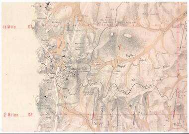
Map - DIAMOND HILL AREA
Copy of map of Diamond Hill area, with the Trig Station mid centre on map. Shafts, mines and geological features are marked.bendigo, mining, diamond hill -
 Bendigo Historical Society Inc.
Document - CENTRAL DEBORAH GOLD MINE: HISTORY AND DESCRIPTION
2 typed copies of history and description of the Central Deborah Mine. Document describes the Historical Record, Historical Background, Brief Chronological History, Some Facts (a brief description of the machinery), Miners' Wages, Price of Gold, Huge Mining Machinery of Other Days, Some Notes on the Geology and the Central Deborah Reefs. Written by A. Richardson. One copy has 1235 D in a circle written on the top left corner and the second copy has Mr John Arthur 15/11/71 30c written across the top.mine, gold, central deborah mine, central deborah gold mine, history of central deborah gold mine, victoria hill, mining machinery, a. richardson, central deborah gold mine geology, central deborah gold mine reefs, price of gold -
 Bendigo Historical Society Inc.
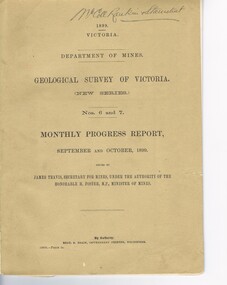
Document - MCCOLL, RANKIN AND STANISTREET COLLECTION: GEOLOGICAL SURVEY OF VICTORIA 1899, 1899
Booklet: 1899 Victoria Department of Mines Geological survey of Victoria (new series Nos. 6 &7. Monthly progress report, September, October issued by James Travis secretary for mines, under the Authority of the Hon. H. Foster M.P. Minister of Mines. McColl Rankin & Stanistreet, 1899 Victoria.MCCOLL RANKIN & STANISTREETorganization, business, industrial - mining, mccoll rankin & stanistreet -
 Bendigo Historical Society Inc.
Document - CENTRAL DEBORAH GOLD MINE - HISTORY OF CENTRAL DEBORAH GOLD MINE 1939 - 1954
... . Also mentioned is the geology and Method of Mining.... History of Central Deborah Gold Mine Geology of the Central ...4 typed pages of the history of the Central Deborah Gold Mine from 1939 to 1954. Mentions the start of mining at this site and Victor Pabst, who in 1917 recommended that the shaft be deepened. His advice was not acted on for another twenty-two years. Also mentioned is the geology and Method of Mining.mine, gold, central deborah gold mine, central deborah gold mine, history of central deborah gold mine, geology of the central deborah gold mine, method of mining -
 Bendigo Historical Society Inc.
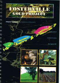
Document - FOSTERVILLE GOLD MINE COLLECTION: PROJECT UPGRADE TECHNICAL APPENDICES
Black cover book, wire binding. Pages in reports numbered individually, overall approx 250 page report. On front: "Fosterville Gold Project' Project upgrade, EES Technical Appendix B. Central North, Central Ellesmere, Harringtons Hill." Page 1 'Perseverance Exploration Pty Limited' Book contains technical appendices. Topics: hydro geological assessment; surface drainage study, noise emission to residential properties, flora survey, tailings dam site; flora survey Wellesford Forest; Daley's Hill Plant List; diurnal Avifauna Survey - Wellesford Forest; survey of vertebrate fauna - Wellesford Forest; brief summary of fauna - Daley's Hill, Axedale, Aboriginal Archaeological survey; archaeological investigation Fosterville; traffic survey - Fosterville Sulphide Project; traffic report.bendigo, mining, fosterville gold mine -
 Bendigo Historical Society Inc.
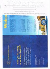
Document - FOSTERVILLE GOLD MINE COLLECTION: OPEN DAY 2019
Two page document for Kirkland Lake Gold Open day 2019. Open Day activities include: bus tours, technical services display, geology, exploration, processing, community and environment display, minerals council of Australia, Swick drilling, Central Deborah Gold Mine, Face painting, Goldfields Re-vegetation, Delecca's hire equipment, MacMahon underground mining services, Sandvik, and ISH24 safety specialists. Map of 'Fosterville Gold Mine Site Map' with activities highlighted. Fosterville is Victoria's larges gold producer and in 2918 a records 356,230 ounces at an average grade of 24.9 g per tonne. The mine has over 600 full time employees in 2019. Entry for '9 levels of darkness' tour at Central Deborah Mine attached.bendigo, mining, fosterville gold mine -
 Bendigo Historical Society Inc.
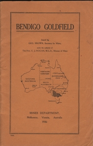
Book - BENDIGO GOLDFIELD
booklet, 51 pages. 'Bendigo Goldfield' issued by Geo Brown, Secretary for Mines. Mines Department 1936. Contains information on the geology of the Bendigo goldfield and major lines of reef and mines. Map of goldfield showing reef lines and mines attached to back cover.bendigo, mining, bendigo goldfield -
Bendigo Historical Society Inc.
Map - GEOLOGICAL MAP OF BENDIGO GOLD FIELD
... BENDIGO Mining Geological Map. H. Herman, Director of Geological ...Two framed laminated maps (a,b) of Bendigo goldfield reef lines, map (b) is a continuation of the reef lines in map (a). On map(a) written in black on top: 'Geological Map, Bendigo Gold Field', Scale of chains, anticlines, synclines, shafts, alluvial and contours marked. Map (b) is continuation of (a). Written on the bottom RH corner of map: 'Prepared in 1923 in the Bendigo Office Mines Department under the direction of H. Herman, Director of Geological Surveys, from surveys by H.S. Whitelaw, Fiield Geologist, assisted by E.S. Usher & J. J. Moore. Re-issued in 1936.'H. Herman, Director of Geological Surveys, from surveys by H.S. Whitelaw, Fiield Geologist, assisted by E.S. Usher & J. J. Moore. Re-issued in 1936.'bendigo, mining, geological map. -
 Bendigo Historical Society Inc.
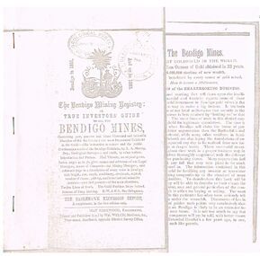
Document - THE BENDIGO MINING REGISTRY
Photocopy of The Bendigo Mining Registry or True Investors guide to all the Bendigo Mines in 1851 and up to 1883. Contains an original poem, Index, names and addresses of Legal Managers, names of Companies and Mining Managers, and reference page to a description of every mine in Bendigo, with length, size, depth, machinery, dividends, capital, number of shares, paid-up, and historical and scientific sketches - past and present - of the main situations. Twelve Lines of Reefs. The Gold Problem Scare Solved. Success of Deep Sinking. E - W & N. S. Parallelograms.document, gold, bendigo mines 1851 - 1883, the bendigo mining registry, r a murray, hay kirkwood, wm welch, district survey office, geological survey of victoria -
Clunes Museum
Plan, 23RD SEPTEMBER,1854
... GOLD MINING .1 .2 HANDWRITTEN GEOLOGICAL SKETCH/PLAN COMBINED ...GEOLOGICAL SKETCH PLAN AND LETTER FOR TWO RIGHTS CLAIMED BY DONALD CAMERON AT "CLUNES" - 320 ACRES IN THE WEST SIDE OF "CRESWICK CREEK" AND 160 ACRES IN EAST SIDE.1 .2 HANDWRITTEN GEOLOGICAL SKETCH/PLAN COMBINED WITH CORRESPONDENCE DATED 23 SEPTEMBER 1854 - FROM THOMAS BURR, SURVEYOR, 1854 AND PROVIDED TO THE SURVEYOR GENERAL. IT RELATED TO TWO RIGHTS CLAIMS BY PRESCRIPTION OF DONALD CAMERON ESQ.local history, plan, donald cameron, thomas burr, gold mining -
Clunes Museum
Map - SURVEYERS MAP OF CLUNES, J. FINNIE, 1883
A SURVEYORS MAP OF CLUNES. GEOLOGICALLY AND TOPOGRAPHICALLY SURVEYED BY R.A.F. MURRAY.LITHOGRAPHED BY R. SHEPHERD AND PRINTED BY J. FINNIE MINING DEPARTMENT, MELBOURNE,1883document, surveyers map of clunes, map of clunes -
Clunes Museum
Document - GEOLOGICAL REPORT, CIRCA 1897
REPORT BY E. LIDGEY, FIELD GEOLOGIST, 1897REPORT ON AURIFEROUS ZONE FROM ROKEWOOD TO CLUNES, AND THENCE TO MOUNT CAMERONSEE OVERlocal history, document, report, mining -
Clunes Museum
Document - REPORTS
... E J Dunn described the geology of the mining in an around... described the geology of the mining in an around Clunes ...E J Dunn described the geology of the mining in an around Clunes and a recommendation for re-commencing mining operations in Clunes 1909.1 PHOTOCOPY OF A PAGE SHOWING RETURNS MADE BY MINING SURVEYORS AND REGISTERS TAKEN FOR THE QUARTER ENDED 31ST MARCH 1875 .2 & .3 PHOTOCOPY OF TWO PAGES OF A GEOLOGICAL SURVEY COMPLETED FOR THE GOVERNMENT (SENT IN 17/5/1909)NILlocal history, document, mining -
Stawell Historical Society Inc
Geological specimen - Mining, Broken Dimond Drill Pieces
... Samples, Basalt - granite Broken Dimond Drill Pieces Geological ...Used to drill through the red Iron stone - reefs end of Stawell. Found along Darlington Road after drilling to erect a Power Pole 2X Cylindrical Broken used Dimond Drill - Core Samples, Basalt - granite -
Stawell Historical Society Inc
Map, Department of Mines Victoria, Alluvial Map Stawell Region, 1870's
c1870 Coloured map showing Black Range North to Stawell and Illawarra. Shows geological layout.Department Mines Victoria 1952/G/2 mining, gold, map -
Stawell Historical Society Inc
Map, Stawell Gold Mine, Provisional Plan Wonga Area, c1980
c1980 Preliminary Provisional Reconnaissance Plan Showing Workings Above and Below water LevelWonga Area 1:1000 Base Geological Sheet mining, gold, map -
Stawell Historical Society Inc
Map, Geological Survey Office, Sloanes & Scotchmans united Mine, December 1916
... grampians mining gold map Geological Survey Office Ballarat December ...Sloane & Scotchman's Geological Survey Map 1916 Showing Underground DrivesGeological Survey Office Ballarat December 1916 mining, gold, map -
Stawell Historical Society Inc
Map, Gold Mines of Australia, Geological Plan Wonga Mine Area Stawell Investigation, 1950
Plans Showing Stawell Investment 1950Gold Mines of Australia Ltd mining, gold, map -
Stawell Historical Society Inc
Map, Gold Mines of Australia, Stawell Investment Geological Plan. Mine Area showing Mineshafts
The Reefs Mine shaft locationsGold Mines of Australia Ltd mining, gold, map -
Whitehorse Historical Society Inc.
Document, Intrusive rocks of Melbourne, 1976
... to be quartz diorite. mines and mining geological society of australia ...Copy of page 373 from 'Geology of Victoria' on intrusive rocks of Melbourne by K.G. Bowen.Copy of page 373 from 'Geology of Victoria' on intrusive rocks of Melbourne by K.G. Bowen. At Tally Ho there is a circular plug, considered to be quartz diorite.Copy of page 373 from 'Geology of Victoria' on intrusive rocks of Melbourne by K.G. Bowen.mines and mining, geological society of australia