Showing 462 items
matching mining sites
-
 Bendigo Historical Society Inc.
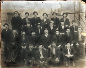
Photograph - NEW CHUM GOLD MINE, c.1911
... Mining site... PLACE Mining site new chum Black and white photograph of shift ...Black and white photograph of shift of miners, New Chum Mine. Four rows of men against background of timber building. Inscriptions: on back - 'The photo of the New Chum Gold Fields Min Diamond Hill, Bendigo was taken about 1911. The manager Wilfred Rickards seated in centre---', 'GH Furness, 116 High Street, Kangaroo Flat'.place, mining site, new chum -
 Bendigo Historical Society Inc.
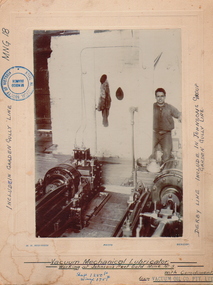
Photograph - JOHNSON'S REEF GOLD LUBRICATOR, c.1880-1890
... Mining site... PLACE Mining site johnson's reef Vacuum mechanical Lubricator ...Vacuum mechanical Lubricator Machinery (vacuum mechanical working at Johnson's Reef Gold, Mine No. 3. Lubricator. Man standing to RH side, hand on lever. Photo mounted on board. Inscriptions: included in Garden Gully Lane MNG18. Derby Line, included in Johnson's Group of Garden Gully Line. Shaft 1250ft. Winze 175ft.place, mining site, johnson's reef -
 Bendigo Historical Society Inc.
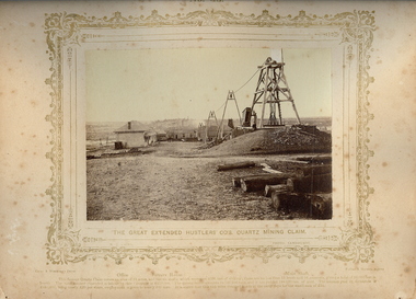
Photograph - VIEWS OF BENDIGO: THE GREAT EXTENDED HUSTLERS CO'S QUARTZ MINING CLAIM, 1875 copy,1970
... Mining site... PLACE Mining site great expended hustler quartz mine See: 'Views ...Sepia photo on cream board. Shows the Great Extended Hustlers Co's. Quartz Mining Claim. In photo, there is an Office, Battery House, Mine Shaft. Three large 'A' frames running a line down to the battery house from the poppet head. Inscription: Above image: 'Views of Bendigo|No.43.'. Below, 'The Great Extended Hustlers Co's. Quartz Mining Claim.', 'N.J.Caire Photo, Sandhurst'. Bottom, 'Casey & Wenborn's Print Forbes & Holmes, Agents',' Office Battery House Main Shaft',' The famous Quartz Claim covers on area of 24 acres, and has six shafts which represent 4000 feet of sinking; there are no less than 13 level and 16 crosscuts, giving a total of 12,000 feet in length. The total amount expended in labour by this Company £228,000. The Quartz raised amounts to 144,500 tons, and it has yielded 188,000 oz's of gold. The amount paid in dividends is £585,600 being nearly £20 per share, employment is given to nearly 200 men. It is stated that this rich mine changed hands in early days for the small sum of £30.'. On Back, RHSV stamp, Bendigo Branch '1959|186'. Nicholas CaireN.J.Caireplace, mining site, great expended hustler quartz mine, see: 'views of bendigo' by n.j.caire -
 Bendigo Historical Society Inc.
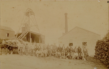
Photograph - MINE
... Mining site... PLACE Mining site mine? Sepia photo on fawn board. 27 workmen ...Sepia photo on fawn board. 27 workmen in front of mine buildings, horse and dray on left, poppet head to left, mine building and chimney stack. Large pile of cut wood on right. 3 men sitting in open windows of building behind group. Blue pencil line drawn on the board, framing the photo.place, mining site, mine? -
 Bendigo Historical Society Inc.
Document - (RONEO-ED) GUIDE TO 'THE RICH VICTORIA HILL AND ITS HISTORICAL ASSOCIATIONS', 1971
... Mining site... PLACE Mining site victoria hill a. and b. Stapled, roneo-ed ...a. and b. Stapled, roneo-ed guide of 10 pages - title 'The Rich Victoria Hill and its Historical Associations. Author: A. Richardson 30/8/1971. (I.e. a Bendigo Historical Society Publication?)place, mining site, victoria hill -
 Bendigo Historical Society Inc.
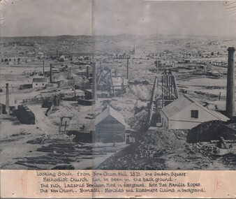
Photograph - LOOKING SOUTH FROM NEW CHUM HILL, 1873
... Mining site... PLACE Mining site new chum Black and white photograph, looking ...Black and white photograph, looking south from New Chum Hill. 1873. The Golden Square Methodist Church can be seen in the background. The rich Lazarus New Chum Mine in foreground. Note Flat Manilla Ropes. The New Chum - Bonatti - Menzies and Ellesmere Claims in background.place, mining site, new chum -
 Bendigo Historical Society Inc.
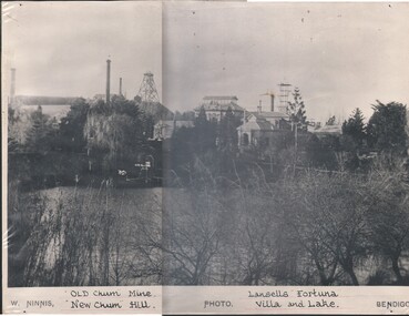
Photograph - FORTUNA COLLECTION: OLD CHUM MINE AND FORTUNA
... Mining site... PLACE Mining site new chum Black and white photograph of Old ...Black and white photograph of Old Chum Mine and New Chum Hill and Lansell's Fortuna with villa and lake. Lake in foreground.place, mining site, new chum -
 Bendigo Historical Society Inc.
Photograph - LANSELL'S 222 MINE, c. 1880's
... Mining site... PLACE Mining site lansell's 222 mine Black and white photograph ...Black and white photograph, taken from the corner of Thistle and Chum Streets, Lansell's 'Fortuna' is in the background. Note is made of the following unusual features: 1. Poppet legs 125 feet high (tallest on the field) on the North side of Chum St; engine house on opposite side. 2. 'Cleopatra Needle' type square - sectioned chimney on left and mullock road, 65 feet from ground at landing brace, where quartz was trucked directly across to Lansell's crushing battery in his 'Fortuna' grounds.place, mining site, lansell's 222 mine -
 Bendigo Historical Society Inc.
Photograph - Victoria Hill, Bendigo, 1973
Gold was discovered on Victoria Hill in 1854 and by 1861, 1,200,000 ounces of gold had been extracted from the site. The first claim was bought for 80 pounds by Prussian immigrant Christopher Ballerstedt and his son Theodore. Christopher Ballerstedt was nicknamed the "Father of the Hill" and was the first to prove that gold reefs extended below the surface. His 200-foot plus mine shafts yielded quartz rich with gold, inspired other miners, and were instrumental in Bendigo becoming the world's deepest and richest goldfield. The site still features relics of nineteenth century mining including quartz crushing machinery and the foundations of George Lansell’s 180 mine. These features are characteristic of Bendigo’s mining history and represent two prominent nineteenth century miners, Christopher Ballerstedt and George Lansell, who held important roles in the development of Bendigo. Victoria Hill Quartz Gold Mines are registered as a site of significance. The site is of historical, archaeological and scientific importance to Victoria. The mines represent the symbolic heart of Bendigo’s gold mining history and the importance that mining played in wealth creation and the development of Victoria. The diggings reserve is accessed from the rear of Albert Richardson Reserve located at 40-56 Marong Road, Ironbark. The site has steep and unformed paths and is closed to the public at dusk. It is important to stay to the paths to avoid the diggings. Interpretive signs help visitors to appreciate the importance of the site and the remaining relics of Bendigo’s mining history.Victoria Hill Ironbark, Bendigo. Photos of the poppet head, sand heap, tailings, shafts and tunnels. Before development into a tourist attraction.history, bendigo, victoria hill, ironbark, diggings -
 Bendigo Historical Society Inc.
Document - DEBORAH REEF PROJECT ENVIRONMENT EFFECTS STATEMENT
Two page document. On top, first page ' Bendigo Mining N.L., Deborah Reef Project, Environment Effects Statement, Summary Brochure'. Poppet head on top LH corner of document. A map of central Bendigo is drawn on page 1 and shows the location of the proposed processing plant near the Airport. Further maps on page 2 and 3 show the North Deborah Mine Site, the pipeline route and the airfield site. The summary brochure provides an outline of the material contained in the Environment Effects Statement and proposed planning scheme amendments upon which, the Deborah Reef Project will be assessed. Page four lists the issues that impact on this submission: planning and land use; socio economic environment; traffic; discharges to air; water management; explosives storage and handling; subsidence; heritage; flora and fauna and landscape and visual assessment. The 16th March, 1989, is the date given for submissions to be lodged in regard to this project.Bendigo Mining N.Lbendigo, mining, deborah reef project -
 Bendigo Historical Society Inc.
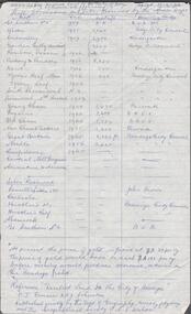
Document - ALBERT RICHARDSON COLLECTION: SHAFTS ALIENATED AND SITES RESERVED BY THE MINES DEPARTMENT
Handwritten one page table of information. On top of page ' Ref. derelict land in the City of Bendigo copied 17.4.62. Shafts alienated and sites reserved by the Mines Dept' List of mines, dates, depth of shaft, receiving body. For example: Londonderry, 1957, 2900 feet, Kindergarten. Reference: 'Derelict Land in the City of Bendigo' P.J. Rimmer and R.J. Johnston. Published jointly by the Dept of Geography, University of Sydney and The Geographical Society of NSW.Albert Richardsonbendigo, mining, derelict land reused -
 Bendigo Historical Society Inc.
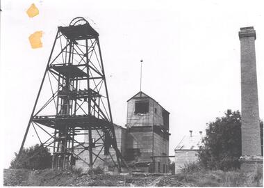
Photograph - DEBORAH GOLD MINE 1930'S
Black and white photograph, copy, of the Big Deborah Gold Mine, possibly taken in the 1930's. Deborah mine was near the junction of Abel and Adam Street, Golden Square. Image shows the mine site, a square brick chimney on the extreme RH side, engine room and stamper sheds in the middle and steel poppet head on LH side. Colour photo of Big Deborah, minus less the winding wheels at the top of the poppet legs.bendigo, mining, deborah gold mine -
 Bendigo Historical Society Inc.
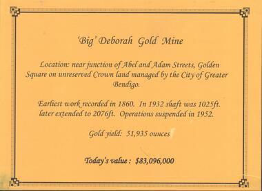
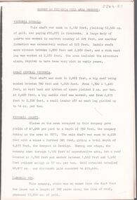
Photograph - DEBORAH GOLD MINE, GOLDEN SQUARE
Information display card regarding the 'Big' Deborah Gold Mine, located near the junction of Abel and Adam Street, Golden Square. Earliest work recorded 1860. Shaft 2076 feet. Operations suspended in 1952. Gold yield 51,935 ounces. Battery shed still on site containing a 5 head stamper which was originally a 20 head stamper. The battery was manufactured by Horwood's Foundry, Bendigo. Photos of mine site taken in 2012: a.Engine room concrete footings, iron work visible. Pepper corn trees in background. Pampas grass in foreground. Steel mesh fence on RH side, enclosing the poppet head site. b. Concrete footings, peppercorn tree in background. c. Corrugated iron shed constructed over the stampers. Steel mesh front. d. Steel poppet head, no winding wheel at top. Pampas grass in foreground. e.. Stamper shed and steel poppet legs in background enclosing dilapidated wooden poppet head legs. f. Close up image of weights in stamper room g.Winding wheel on stampers h.Looking upwards to top of stampersbendigo, mining, deborah gold mine -
 Bendigo Historical Society Inc.
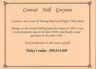
Document - CENTRAL NELL GWYNNE GOLD MINE
Interpretive sign and 4 photos Central Nell Gwynne Gold Mine, used in display. Central Nell Gwynne was located near the corner of Marong Road and Happy Valley Road. Opened in 1906, ceased operation in December 1949. Total production: 61,884 ounces of Gold. Today's Value: $99,014,400. Photos: a. Colour photo, concrete footings at mine site, April 2012. b. Colour photo, Central Nell Gwynne poppet head, April 2012.Poppet head painted white with red trim. Concrete footings in foreround. c. Central Nell Gwynne mine site 1930's. Poppet head and engine room sheds on LH side, trestle way to primary crusher and crushing battery. Tailing dam in immediate foreground. on RH side. Sand heaps in middle foreground. d. Central Nell Gwynne Mine 1930. Underground view, men holding carbide lamps working at 265 level in mine. Large quartz spur formation visible in foreground.bendigo, mining, central nell gwynne -
 Bendigo Historical Society Inc.
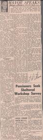
Newspaper - ALBERT RICHARDSON COLLECTION: THE MAYOR SPEAKS: MINE SITES
Newspaper article 'The Mayor Speaks' dated 12th August 1967, Bendigo Advertiser. Article by J.R. Flood. Mayor of Bendigo, detailing the location of mines including the Duchess of Edinburgh on the New Chum line, the mines on the Christmas line of reef, the Deborah reef mines, and the Sheepshead reef. Mine reclamation schemes are also addressed in the articlebendigo, mining, reef lines and mines -
 Bendigo Historical Society Inc.
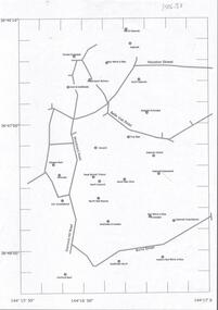
Document - CENTRAL DEBORAH GOLD MINE : GOLDEN SQUARE MINE SITES
... BENDIGO Mining golden square mine sites Map showing mines ...Map showing mines in the Golden Square, Diamond Hill area. Roads include Diamond Hill Road, Burns Street, Woodward Road, Belle Vue Road, Houston Street. Latitude and Longitude on map.bendigo, mining, golden square mine sites -
 Bendigo Historical Society Inc.
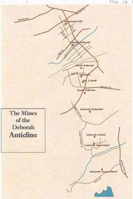
Document - THE MINES OF THE DEBORAH ANTICLINE
Plan of the mines along the Deborah Anticline: Deborah Consolidated, Deborah Associated, Deborah United, Deborah Extended, South Deborah, No. 2 shaft, Deborah North Deborah, Central Deborah, Monument Hill are all sited on the plan.Philip Wilkin, volunteer, BHSbendigo, mining, deborah line of reef -
 Bendigo Historical Society Inc.
Document - ALBERT RICHARDSON COLLECTION: VICTORIA HILL IRONBARK
... of the Victoria Hill site as a potential mining museum is discussed... of the suitability of the Victoria Hill site as a potential mining museum ...Three page handwritten document outlining the history of the Victoria Hill area. The open cuts on Victoria Hill; Lansell's Big 180 Mine, Victoria Quartz Mine; Wittscheibe's 'Jewellers Shop', Luffman and Sterry, Central Nell Gwynne and New Chum Hill are mentioned in the article. A description of the suitability of the Victoria Hill site as a potential mining museum is discussed as 'it is centrla to both the northern and southern ends of the main portion of the Bendigo and Eaglehawk mines'. William Rae built two fine residences on Happy Valley Road, and also set up a 30 head battery out of his gains from Victoria Hill.bendigo, mining, victoria hill -
 Bendigo Historical Society Inc.
Document - ALBERT RICHARDSON COLLECTION: HERCULES AND ENERGETIC
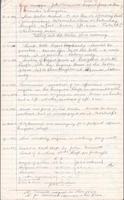
a. Five page handwritten document titled 'Mine Manager John Truscott's Report Hercules and Energetic' Other reports included from Mine Managers on the Hercules and Energetic Mines are: J. Woolcock's report 4.3.1895, F. Youlden 1898 and J. Roberts 1911. b. One page hand drawn plan of titled ' Hercules transverse plotted by A.E. R., .D., A.A., page 23, 24.3.37. Hercules Long, by A.E.K. , W.R.N 24.3.37. Plans show measurements of tramway, height of poppet head, position of ore bins and other buildings on mine site.Albert Richardsonbendigo, mining, hercules and energetic mine -
 Bendigo Historical Society Inc.
Photograph - NORTH DEBORAH GOLD MINE BENDIGO MINING PLAQUE
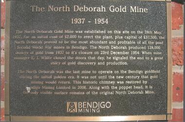
Metal plaque, gold writing, erected at the site of the former North Deborah Gold Mine when the brick chimney was restored by Bendigo Mining NL. The plaque reads: 'The North Deborah Gold Mine, 1937-1954. The North Deborah Gold mine was established on this site on the 28th May 1937. For an initial cost of 2,000 pounds to erect the plant, plus capital of 37,500 pounds, the North Debnorah proved to be the most abundant and profitable of all the post Second War mines in Bendigo. The North Deborah produced 128,000 ounces of gold from 1937 to its closure on 23rd December 1954. When mine manager E.J. White closed the doors that day he signaled the end to a great story of gold discovery and production. The North Deborah was the last mine to operate on the Bendigo goldfield during the initial golden era. It was not until the new century that gold mining would return. This historic chimney was restored by Bendigo Mining Limited in 2006. Along with the poppet head. It is the only visible surface remains of the original North Deborah Mine.' The mine site is situated off Breen Street in Golden Square.Kay MacGregor 2012bendigo, mining, north deborah mining company -
 Bendigo Historical Society Inc.
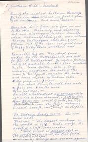
Document - ALBERT RICHARDSON COLLECTION:VICTORIA HILL NOTES
Thirteen page document with notes about Victoria Hill, some handwritten by Albert Richardson. Mine managers' reports, extracts from mining texts and an undeground diagram of the Hill are included. Dimensions of Lansell's 222 mine poppet head are described and draft notes regarding the possible interpretive signage on Victoria Hill sites for tourism.bendigo, mining, victoria hill -
 Bendigo Historical Society Inc.
Book - TOURING SACRED MINE SIGHTS OF BENDIGO, 1994
16 page booklet 'Touring Sacred Mine Sights of Bendigo' Produced by Bendigo Mining and the Victorian Chamber of Mines.1994. Researched and written by David Horsfall and printed by Bendigo Modern Press. Details and suggested walking and driving tours of old mine sites. Includes 3 maps.David G Horsfall -
 Bendigo Historical Society Inc.
Letter - KANGAROO FLAT MINE SITE COLLECTION: WESTERN MINING LETTERS RE EXPLORATION
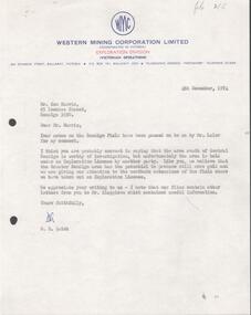
... KANGAROO FLAT MINE SITE COLLECTION: WESTERN MINING LETTERS... KANGAROO FLAT MINE SITE COLLECTION: WESTERN MINING LETTERS RE ...Letter from Western Mining Corporation to Mr Ken Harris of 85 Lowndes Street, Bendigo, 4th December 1974, concerning the exploration of the area south of Central Deborah Gold Mine. Ken Harris sent briefing notes on Bendigo mining to Mr. A.H Parbo, the Chairman and Managing Director of Western Mining Corporation, which were then passed onto D.R. Quick of WMC, the author of this letter.bendigo, gold mining, exploration, bendigo, western mining corporation, gold mining, central deborah, a.h. parbo, ken harris -
Bendigo Historical Society Inc.
Document - GREAT EXTENDED HUSTLERS: MAPS OF HUSTLERS MINE SITE
Three maps, copies. Great Extended Hustlers mine site. Hustlers Royal Reserve No. 2 Mine. Streets around Great Extended Hustlers mine site and reserve.bendigo, mining, great extended hustlers -
 Bendigo Historical Society Inc.
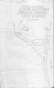
Photograph - DIAMOND HILL 1936, PLAN OF OCCUPATION
Print of 'Application of J. Hattam, plan of occupation parish of Sandhurst, County of Bendigo' Plan shows Post Office site, large dam, 'formerly cultivated site near Post Office'. A un-named gully is marked.bendigo, mining, diamond hill -
 Bendigo Historical Society Inc.
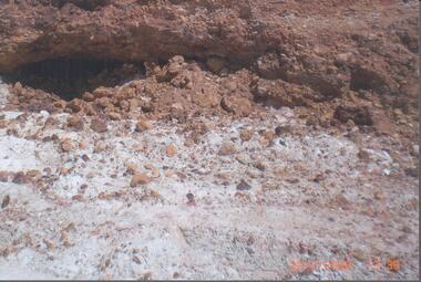
Photograph - RALPH BIRRELL COLLECTION: WHITE HILLS MINING SITE
... RALPH BIRRELL COLLECTION: WHITE HILLS MINING SITE...) Photograph RALPH BIRRELL COLLECTION: WHITE HILLS MINING SITE ...Colour photograph 'showing tunnels below the cement where the miners chipped the undersurface to get the gold The thickness of the cement can be seen'. Loose sand and gravel above the cement has already been removed. Image shows mining tunnel visible going in under the cement. White clay in foreground. (see Mosaic 4400.220 for detailed information regarding the White Hills, written by Dr. Ralph Birrell)bendigo, mining, white hills -
 Bendigo Historical Society Inc.
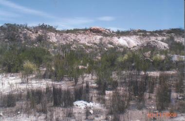
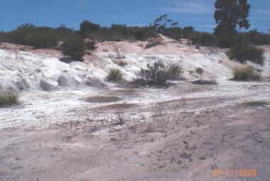
Photograph - RALPH BIRRELL COLLECTION: VIEW OF WHITE HILL
Colour photograph of White Hill area - possibly at First White Hill. Image shows white clay and gravel, low level bushes, possibly Chinese Scrub on site. 'The rim of the pit showing an exposed boulder in situ' ( in foreground of image ) (see Mosaic 4400.220 for detailed information regarding the White Hills, written by Dr. Ralph Birrell)bendigo, mining, white hills -
 Bendigo Historical Society Inc.
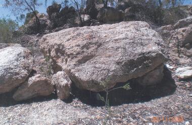
Photograph - RALPH BIRRELL COLLECTION: BOULDER ON WHITE HILLS SITE
Colour photograph of 'an exposed cement boulder on the site' of the first White Hill. (see Mosaic 4400.220 for detailed information regarding the White Hills, written by Dr. Ralph Birrell)bendigo, mining, white hills -
 Bendigo Historical Society Inc.
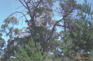
Photograph - RALPH BIRRELL COLLECTION: TREE AT FORMER GUNPOWDER MAGAZINE, WHITE HILLS
Colour photograph of tree 'planted around the gunpowder magazine site in the 1880's, most of which still remain' at White Hills, Bendig ( at the end of Riley Street) The magazine keeper's residence is nearby and is in use as private residence. A magazine for gelignite was built nearby on the site of the Bendigo East School in 1883 and was pulled down in 1915. (see Mosaic 4400.220 for detailed information regarding the White Hills, written by Dr. Ralph Birrell)bendigo, mining, white hills -
 Bendigo Historical Society Inc.
Photograph - RALPH BIRRELL COLLECTION: THE WHITE HILLS
Colour photograph of White Hills,' site adjacent to the Railway Workshops at the end of Riley Street showing the sands and gravels sitting on the white gravel and clay' written on enclosed description by Ralph Birrell. (see Mosaic 4400.220 for detailed information regarding the White Hills, written by Dr. Ralph Birrell)bendigo, mining, white hills