Showing 891 items
matching network
-
 Greensborough Historical Society
Booklet, BNLLEN, BNLLEN Annual Report 2019, 2019_
2019 Annual Report for BNLLEN (Banyule Nillumbik Local Learning & Employment Network). Outlines activities, staff and finances for the year. BNLLEN provides education, training and employment pathways for young people.22 pages, colour illus.bnllen, banyule nillumbik local learning & employment network, youth employment -
 Greensborough Historical Society
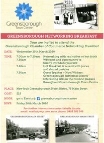
Flyer - Leaflet, Greensborough Networking Breakfast 2020, 25/03/2020
The Greensborough Chamber of Commerce Networking Breakfast was held at the Greensborough Hotel Bistro on Wednesday 25th March 2020 with guest speaker Noel Withers of GHS speaking about the historic plaques in the town centre.Single page, printed in colour on one side.greensborough chamber of commerce, noel withers, main street plaques project -
 Port Melbourne Historical & Preservation Society
Photograph - Fundraising stall, Port Melbourne Picket Group, Bay Street, Pat Grainger, 1988
Concerned residents held a picket to protest against the withdrawal of heavy rail, and its replacement with light rail. Closure of the railway would involve the loss of the connection with Flinders St, and the rest of the rail network.Photograph of Port Melbourne Picket group holding a fund raising stall in Bay St, c1988public action campaigns, societies clubs unions and other organisations, transport - railways, port melbourne picket group, railway reserve, amelia finch, lloyd finch -
 Bacchus Marsh & District Historical Society
Map, Plan showing relative positions of the Gisborne road formation and Mr. Cosgrove's land in Darley. 1907
No background information about the roadworks referred to in this plan has been found. The portion of land referred to as 'Cosgroves' in this plan is located close to the present day Darley Park Recreation Park in Darley, near Bacchus Marsh. The land indicated appears to be close to the corner of Grey Street and Gisborne Road. James Cosgrove who died in 1923 aged 65 owned a farm of 52 acres in this area of Darley.Single page map showing a proposed deviation of the Gisborne road in Darley and its position relative to land owned by Mr. Cosgrove. The land owned by Cosgrove is shaded in pink. No scale indicated. Part of a set of maps which are pasted into a bound volume containing 76 maps or plans in total. High resolution digital image stored on BMDHS computer network. Signature (illegible), Eng, Bac Marsh Shire, 30/9/07bacchus marsh roads and streets, darley victoria maps -
 Bacchus Marsh & District Historical Society
Map, Village allotments, Parish of Myrniong, County of Bourke
Myrniong is a village 9 kilometers west of Bacchus Marsh. Prior to 1863 the area was known as Blow's Flat. This map which was produced in 1903 and according to the catalogue record of this map held at the State Library of Victoria was based on an earlier map created in 1861. The early layout of streets for the village of Myrniong can be seen on this map. The streets shown are, Main Street, Hardy Street, Blow Street, Myrniong Street, Shuter Street, and Blackwood Street. An area marked as a reserve for a school can be seen between Hardy Street and Main Street.A single page paper map. A cadastral parish map of Myrniong in Victoria, showing numbered land allotments. Photo-lithographed at the Department of Lands & Survey, Melbourne, in 1903. Based on an original map created in 1861. The map is pasted into a bound volume containing 76 maps or plans in total. High resolution digital image stored on BMDHS computer network. Surveyed by John Hardy, Surveyor ; photo-lithographed at the Department of Lands & Survey, Melbourne by T.F. McGauran, 24.12.03myrniong parish plan, myrniong parish maps -
 Melbourne Tram Museum
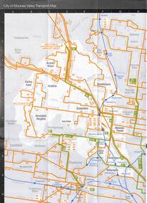
Map, Metlink, "Your Guide to Melbourne's Public Transport System - City of Manningham", "City of Moonee Valley", c2005
Map - 18 fold - 6x3 - pocket size, printed in full colour, titled "Your Guide to Melbourne's Public Transport System - City of Manningham", published by Metlink c2005. Has a map of transport routes in the City of Manningham, details of Metcards, bus routes, maps of the tram and train network and Metcard agents. .2 - as for .1, but for the City of Moonee Valleytrams, tramways, maps, city of manningham, city of moonee valley -
 Melbourne Tram Museum
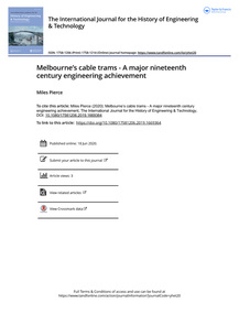
Document - Report, Miles Pierce, "Melbourne's cable trams - A major nineteenth century engineering achievement", 1919 - 1920
Research report - 28 A4 pages + cover sheet, titled "Melbourne's cable trams - A major nineteenth century engineering achievement", written by Miles Pierce and published in the June 2020 issue of "The International Journal for the History of Engineering & Technology" Paper looks at the history of the cable tram network in Melbourne, its construction, financing, operation, technology and its place in the world.trams, tramways, cable trams, melbourne, construction, operations -
 Bacchus Marsh & District Historical Society
Map, Lerderderg Gorge Road Goodmans Creek to Gisborne Road
The date of this map and its purpose has not been established. It was possibly produced to indicate landholders who were impacted by works along the Lerderderg Gorge Road. A single page paper map showing various blocks of land along the route of the Lerderderg Gorge Road near Bacchus Marsh from Goodmans Creek to the point where the road joins with Gisborne Road. The map is pasted into a bound volume containing 76 maps or plans in total. High resolution digital image stored on BMDHS computer network. bacchus marsh victoria maps, lerderderg gorge road bacchus marsh maps -
 Melbourne Tram Museum
Newspaper - Newspaper clipping, The Age Newspaper, "Trams CEO on a track to lift service", 01/07/2023
Interview with Yarra Trams CEO, Carla Purcell. Appointed to CEO role by Yarra Trams owner Kelli's Downer in November 2022, but started in April 2023 after returning from maternity leave. Tender process is underway for next tram franchise, currently worth $500M per year. Yarra Trams have operated the network for 13 years with current contract expiring at end of 2024. Tram patronage currently at 75% of pre-Covid levels. Melbourne's tram network currently consists of 475 trams, 250 km of track, 2300 employees servicing 200M annual passengers.Informative interview with Carla Purcell, CEO of Yarra TramsNewspaper clipping from the Age titled: "Trams CEO on a track to lift service"tramways, ceo, yarra trams, keolis downer-edi, tender documents, trams -
 Melbourne Tram Museum
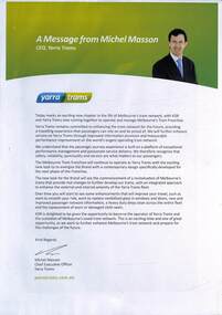
Poster, Yarra Trams, "A message from Michel Masson", Nov. 2009
Poster with a message from Michel Masson, Yarra Tram's CEO after Keolis Downer - EDI took over the franchise for the operation of Melbourne's tram network. See also item 833 for associated details. November 2009.Yields information about the Keolis Downer EDI outlook on the operation of the Yarra Tram's network.Full colour poster printed on an A4 sheet.trams, tramways, posters, yarra trams, michel masson, keolis downer-edi -
 Queen Victoria Women's Centre
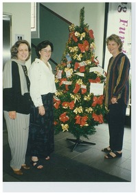
Photograph, December 1997
Colour photograph. Christmas 1997 Networking and Shilling Fund Breakfast. Three women are standing in the ground floor north foyer of the QVWC building. They stand around a Christmas tree adorned with multiple and various dollar notes. Left to right: Glenys Sharma (first General Manager), Kerri Ward (Marketing from Francis Tobin & Associates) and Janet England (first Chair of the Trust). Was a standard size but has been cut. christmas decorations, christmas, fundraising events -
 Bacchus Marsh & District Historical Society
Map, Coimadai Parish Map, County of Bourke. Circa 1890s-1900s
The cadastral Parish of Coimadai, a subdivision of the County of Bourke, lies directly north of the township of Bacchus Marsh. The date of this map is uncertain. T.F. McGauran the person who made a photo-lithographic copy of the map was in charge of photo-lithography at the Victorian Department of Lands and Survey in the late 19th century until about 1910.A single page paper map showing the map for the Parish of Coimadai in the County of Bourke. A cadastral map showing parish boundaries and land ownership. A rectangle shaped area is missing from the centre of the map due to a tear or deliberate excision. The map is pasted into a bound volume containing 76 maps or plans in total. High resolution digital image stored on BMDHS computer network. Photo-lithographed at the Department of Lands and Survey, Melbourne by T.F. McGauran 26.8.[??] NOTE. Photo litho from L.P showing temporary surveys and occupation of land prepared for departmental use onlybacchus marsh region parish plans, coimadai parish maps, coimadai parish plan -
 Bacchus Marsh & District Historical Society
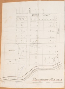
Map, Langmann's Estate Bacchus Marsh
The date of this map has not been determined. It bears the signature of D.A. Little upon of a portion of the map. Little was Bacchus Marsh Shire Secretary and Engineer between 1886 and 1914 which dates the map to some time between 1886 and 1914.A single page paper map showing a portions of land in part of Bacchus Marsh.The area shown is described as Langmann's Estate. The area is bounded by the Werribee River, Fisken Street, Waddle Street(sic.) (Waddell) and Lord Street. The map is pasted into a bound volume containing 76 maps or plans in total. High resolution digital image stored on BMDHS computer network. interim map record stage 1, bacchus marsh victoria maps -
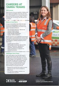 Melbourne Tram Museum
Pamphlet, Keolis Downer, "Careers at Yarra Trams", c2016
Pamphlet - single side A4 sheet, printed in full colour "Careers at Yarra Trams" outlining Keolis Downer as the operator of the Melbourne network, roles (non operational) available at Yarra Trams, and working at Yarra Trams. Written to promote women in Yarra with numbers giving showing the participation by women since July 2014. Has Keolis Downer and Yarra Trams logos.trams, tramways, yarra trams, women, keolis -
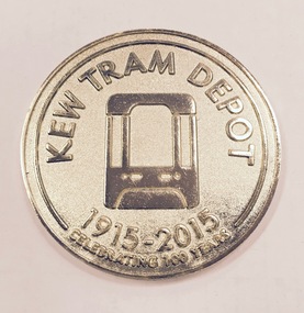 Kew Historical Society Inc
Souvenir - Medallion, Kew Tram Depot 1915-2015, 2015
Kew tram depot is located on the corner of Barkers Road and High Street, Kew, a suburb of Melbourne, Australia. Operated by Yarra Trams, it is one of eight tram depots on the Melbourne tram network. The depot opened on 8 May 1915.Commemorative medallion in blue presentation box, given to the Kew Historical Society on the anniversary of the Kew Depot in 2015.Front: Schematic engraving of tram with the words "Kew Tram Depot : 1915-2015 : Celebrating 100 Years". Reverse: Schematic engraving of exterior of Depot, surrounded by the words "Commemorating all staff who have contributed to the success of Kew Depot".kew tram depot, commemorative medallions, tramways memorabilia -
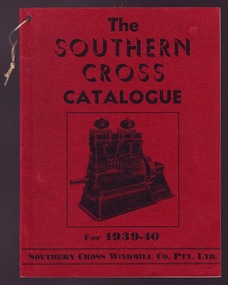 Mansfield Historical Society
Book, "The Harbour" Newspaper & Publishing Co Ltd, Southern Cross Catalogue 1939-40, 1939
The Southern Cross Organisation had its origin in a small Foundry in Toowoomba, Queensland, in 1871, and has grown into a Commonwealth-wide organisation with a selling network serving the whole of Australia and supplying Southern Cross Products as far away and Deccan, in India.This object is significant because it is complete and the pages are clean, straight & unmarked with the binding is in good condition.Soft Red CoverSouthern Cross Catalogue for 1939-40windmills, petrol engines, kerosine engines, pumps, milking machines, tanks, lighting plants, home light batteries -
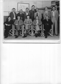 Kiewa Valley Historical Society
Photos - 1. Mt Beauty R.S.L. Committee 1949-1950 2.ANZAC service at Mt Beauty cearly 1950s
R.S.L. is the Returned and Services League of Australia, a member based charity founded in 1916, and the largest veterans' charity in Australia. It provides a support network and community for veterans and their families. They have a commemorative service each year on 25th April, ANZAC Day.The Mt Beauty RSL committee members in 1949 is a list of people living in Mt Beauty at the time and who were working as a support team for veterans and their families. The ANZAC crowd at the temporary memorial indicate the interest in the town for a commemoration and the need for a more permanent structure.Both Black & White large photos. 1. Group of men - Mt Beauty R.S.L. Committee with names on reverse. 2. Anzac Day at Mt Beauty. Early 1950s. People including school children, gathered around a temporary war memorial structure near the current (2023) roundabout. In the background is the main workshop. The Tail race channel hasn't been constructed. On the back in pen of RSL photo: Mt Beauty R S L Committee 1949 -50 / Standing Fred De Little, Roy Cobby, WaJ. Jones/ Joe Lang, Ian Bennett, Stan Leanard, Ted White/ Seated / Harry Edney, Jack Chapman (Tres), Harold Boon (Pres), R Webster (Sec), /Joe Breen returned services league, anzac day, rsl 1949 -
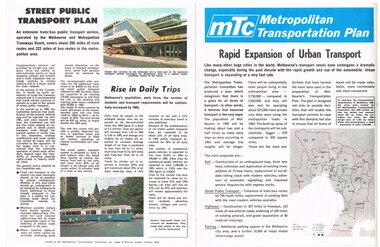 Melbourne Tram Museum
Pamphlet, The Metropolitan Transportation Committee, "Metropolitan Transportation Plan - Rapid Expansion of Urban Transport", c1968-69
Pamphlet full colour, four pages, printed on off white paper titled "Metropolitan Transportation Plan - Rapid Expansion of Urban Transport", issued by the Metropolitan Transportation Committee, c1968 - 69, explaining the planning of the Committee for Melbourne's transport in 1985. Looks at the future of Melbourne's rail, bus, tram and road network. Includes the survey and implementation. See Reg Item 623 for part of the final plan.trams, tramways, melbourne, road transport, tramways, railways, public transport, transportation plan -
 Melbourne Tram Museum
Document - Press Release, Yarra Trams, "A Century of Electric Trams in Melbourne", 5/05/2006 12:00:00 AM
Printed Press Release or Media Release, titled "A Century of Electric Trams in Melbourne", dated 5/5/2006 giving details of the event, the forthcoming weekend and quotes Mr. Dennis Cliche. Gives details of forthcoming events, and that Yarra Trams is celebrating its second anniversary of Yarra Trams taking responsibility for Melbourne's entire network. Included a flyer - same as Reg 841 - but included with this item.trams, tramways, yarra trams, centenary, 100 years of electric trams, st kilda, essendon, nmetl -
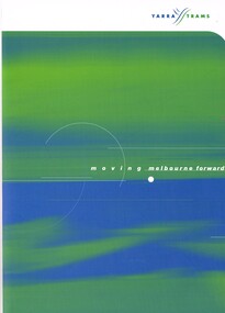 Melbourne Tram Museum
Document - Folder, Yarra Trams, "Moving Melbourne Forward", c2000
Printed folded heavy card folder with the title "Moving Melbourne Forward", able to contain papers, but more providing information about Yarra Trams following the formation of Yarra Trams - Transdev and Transfield in 1999. Notes Yarra trams "owns" 201 trams and 130km of track. Has a message from the CEO Hubert Guyot and details of the network and Yarra's visions for the future. Two copies held.trams, tramways, yarra trams, tramways, melbourne, transfield, transdev -
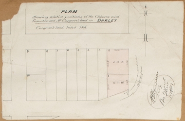
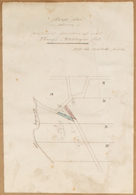
![Map, [Plan for road to give J. Allan access to permanent water at Coimadai] circa 1870s](/media/collectors/5e461d8021ea67224c82f2a1/items/67735190d671e67dd573a84c/item-media/6773533dd671e67dd573cd90/item-fit-380x285.jpg) Bacchus Marsh & District Historical Society
Bacchus Marsh & District Historical SocietyMap, [Plan for road to give J. Allan access to permanent water at Coimadai] circa 1870s
The date of this map or plan is uncertain but it appears to be from the early to mid 1870s. One of the landholders identified on the plan, James Allan of Coimadai died suddenly on the 9th July, 1874 (see Bacchus Marsh Express, 11 July, 1874, page. 3). There are mentions of an Allans Road at Coimadai in the Bacchus Marsh Express between 1887 and 1942.Single page map showing an excision of land belonging to Charles Ross which was selected to construct a road to give another landholder, J. Allan access to permanent water. Scale 1 chain to 1 inch. Part of a set of maps which are pasted into a bound volume containing 76 maps or plans in total. High resolution digital image stored on BMDHS computer network. Plan showing Excisions from Ross's selection and 1 chain road thro' the said selection in Coimadai to give J. Allan access to permanent water. Alistair ?? Shire Eng? 6?/5/7?coimadai victoria maps, coimadai roads and streets -
 Bacchus Marsh & District Historical Society
Map, Rough plan showing proposed deviation of road through McKenzie's Flat
The date of this map or plan is uncertain. McKenzie's Flat is a bushland picnic area on the Lerderderg River in the Lerderderg State Park close to Bacchus Marsh. Single page map showing a proposed deviation of the road near the McKenzie's Flat area close to Bacchus Marsh. The proposed deviation is shaded in pink, The existing road section to be replaced is shaded in blue. No scale is indicated. Part of a set of maps which are pasted into a bound volume containing 76 maps or plans in total. High resolution digital image stored on BMDHS computer network. mckenzies flat bacchus marsh, bacchus marsh roads and streets -
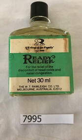 Greensborough Historical Society
Domestic object - Bottle, W. T. Rawleigh Co. Ltd, Ready relief, 1950s
One of a range of medicinal, cosmetic and other consumer products manufactured in Melbourne and sold by "door-to-door" Rawleigh salesmen in Australia from 1928. Now sold through a network of Rawleigh distributors, located in regional towns and state capitals throughout Australia.Clear glass 30 ml bottle with black bakelite screw top, containing "Ready relief" fluid used against discomfort of head colds and nasal congestion. Black and green printed label"Rawleigh 'Friend of the Family"medicines, rawleigh, w.t. rawleigh co. ltd., cold medicines -
Bialik College
Mixed media - WIZO Medal 1982
Presented to Bialik from the Women’s International Zionist Organisation (WIZO); Israel's leading organisation for education and social services, promotes an equal society for all supported by a global network of Zionist women. Please contact [email protected] to request access to this record. An appreciation trophy to Bialik from Women’s International Zionist Organisation (WIZO). A resin puck, with a flat bottom, 9cm across and 2.5cm thick. Inside the clear resin is a medal. One side has the words WIZO, with an image signifying a mother and baby. The reverse has more text, likely Hebrew, with images of women and children working and being together, trees are a feature of these scenes.Please contact [email protected] to request access to this record. A small metal strip, glue worn off and sticky tape not adhering, has been engraved with the words: Presented to Bialik College In Appreciation March 1982 judaism, women, zionist, medal, 1980s -
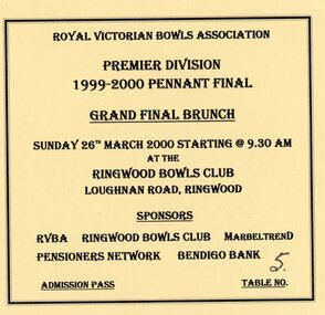 Ringwood and District Historical Society
Document, Ringwood Bowls Club- Ticket to RVBA Premier Division 1999-2000 Pennant Final Grand Final Brunch at Ringwood Club, March 2000
Yellow coloured cardboard ticket.Royal Victorian Bowls Association Premier Division 1999-2000 Pennant Final Grand Final Brunch Sunday 26th March 2000 starting @ 9.30 am at the Ringwood Bowls Club, Laughnan Road, Ringwood. Sponsors: RVBA, Ringwood Bowls Club, Marbletrend, Pensioners Network, Bendigo Bank. Admission Pass, Table No 5. -
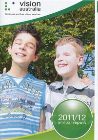 Vision Australia
Administrative record - Text, Vision Australia 2011-2012 annual report, 2012
Annual report providing overview of activities and achievements including: development of VicKids Alliance to provide services to children, inclusion of Adelaide's 5RPH to the network, change in funding due to the introduction of the NDIS, launch of first Reconciliation Action Plan, and relocation of Southport office to Robina.1 volume with illustrations providing overview of organisational achievementsandrew moffat, stephen crook, michael simpson, jan chisholm, bill mudford, pam mudford, myles tankle, steph mccorkell, barry johnston, rolf geerlings, andrew rochford, kathy fela, gaynor marsh, alan roberts, chaeyon seo, malek chamoun, emily white, aviva mushin, heidi clarke, dianne arnold, corporation records, vision australia, kevin murfitt, owen van der wall, keith barton, paul gleeson, ross mccoll, theresa smith-ruig, jan lovie-kitchin, nick carter, ron mccallum, david speyer, donald fraser, lyn allison, michael hansen, glenda alexander, maryanne diamond, leigh garwood -
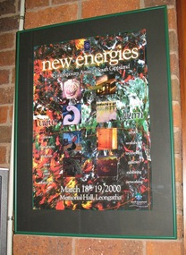 South Gippsland Shire Council
Poster, Framed, New Energies
Framed colour poster titled: "new energies/Contemporary Artists of South Gippsland" 18-19 March 2000, Memorial Hall, Leongatha. Black card window mount set in green powder coated metal frame. features a photomontage of art and craft images with text headings which include: "ceramics, photography, sculpture, print, paint, furniture, advice, workshops, technology, galleries, exhibitions, and networking". -
 Bacchus Marsh & District Historical Society
Map, Plan of land purchased by the Bacchus Marsh Shire Council from Mr. T. Low for a deviation of the Melbourne to Ballarat main road. 1877
The date of this plan is 1877 and the land indicted on it required for a road deviation is shaded in blue. It adjoins the Korkuperrimul Creek on one side which indicates the land is located just a few kilometers to the west of Bacchus Marsh. Single page map showing a portion of land purchased by the Bacchus Marsh Shire from Mr Thomas Low for the purpose of a road deviation. Land held by David Robertson is also shown on the map. Scale: 2 chains to 1 inch. Part of a set of maps which are pasted into a bound volume containing 76 maps or plans in total. High resolution digital image stored on BMDHS computer network. Surveyed by W. E. Standfield, Shire Engineer, Bacchus Marsh, 12/4/77bacchus marsh roads and streets, melbourne to ballarat road -
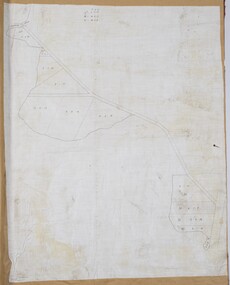
 Bacchus Marsh & District Historical Society
Map, Gaynor Street Area Land Sales, Maddingley, 1888
This map was produced for a major sale of land in the Maddingley area of Bacchus Marsh in 1888. The sale was conducted by two firms from Melbourne, Carney and Kelly 12 Swanston Street Melbourne. and 'Richardson, Kerr & Co. 40 Flinders Lane Melbourne. 136 blocks were for sale.A single page paper map showing land allotments for sale in the Maddingley area of Bacchus Marsh. Locations shown include Gaynor Street, Maddingley Road South, Parwan Road, Mitchem Street, Typpynge Street, Finn Street and East Maddingley Road. . The map is pasted into a bound volume containing 76 maps or plans in total. High resolution digital image stored on BMDHS computer network. bacchus marsh victoria maps, maddingley victoria maps, land use, maddingley victoria history, land sales bacchus marsh, land sales maddingley -
 Bacchus Marsh & District Historical Society
Map, Gaynor Street Land Sales, Maddingley, circa 1880s-1890s
This map was produced for a major sale of land in the Maddingley area of Bacchus Marsh. The precise date of the sale has not been determined. Features present on the map such as the Bacchus Marsh Railway Station indicate the land sale must have taken place some time after 1887 when the Railway Station opened. A single page paper map showing land allotments for sale in the Maddingley area of Bacchus Marsh. Locations shown include Gaynor Street, Maddingley Road South, Parwan Road, Mitchem Street, Typpynge Street, Finn Street and East Maddingley Road. . The map is pasted into a bound volume containing 76 maps or plans in total. High resolution digital image stored on BMDHS computer network. bacchus marsh victoria maps, maddingley victoria maps, land use, maddingley victoria history, land sales bacchus marsh, land sales maddingley