Showing 488 items matching "north avenue"
-
 Ringwood and District Historical Society
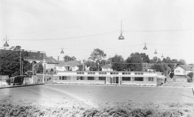
Photograph, Ringwood Bowling Green, November 1969, with Eastland (far left) and houses in Adelaide Street and Miles Avenue
Eastland to left, Adelaide St and Miles Ave with housesWritten on catalogue card, "Ringwood Bowling Green, November 1969". -
 Ringwood and District Historical Society
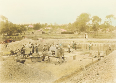
Photograph, Construction of Ringwood baths, Miles Avenue. Construction began in January 1934 and the pool was officially opened in November that year
Coloured photograph. Photograph taken by "Mervyne" Ringwood Studios."Written on back of photograph" Ringwood baths under construction. Photo taken from corner of Ringwood St & Miles Ave. Houses just above baths are in Reynolds Ave & top left in Warrandyte Road. Top centre- corner Warrandyte Road & Woodside Ave. White railing centre right is on the bridge across Mullum Creek. Adelaide St ran from Maroondah Highway to Reynolds Ave. Bridge later washed away- 1931. -
 Ringwood and District Historical Society
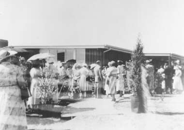
Photograph, Official opening of Greenwood Park Kindergarten, Greenwood Avenue, Ringwood on 10th December 1955. Speeches at official opening - Mrs. Helen Austin, Lady Violet Brooks, with Mrs. B. Hubbard, Mayoress, Cr. Ben Hubbard, Mayor, Mr. Roy Wilkins and Dr. B. Meredith looking on
Typed below photograph, "3. Speeches at official opening - Mrs. Helen Austin, Lady Violet Brooks, Mrs. B. Hubbard, Mayoress, Cr. Ben Hubbard, Mayor, Mr. Roy Wilkins, Dr. B. Meredith, Mrs. E.V. Pullin extreme right edge". -
 Ringwood and District Historical Society
Photograph, Official opening of Greenwood Park Kindergarten, Greenwood Avenue, Ringwood on 10th December 1955. Lady Brooks being escorted for refreshments by Mrs. E.V. Pullin. Also Mrs. Edna Lewis with her back to the camera and Mrs. Pam Gallienne next to her
Typed below photograph,"5. Lady Brooks taken for refreshments by Mrs. E.V. Pullin. Back of Mrs. Edna Lewis - Mrs. Pam Gallienne". -
 Ringwood and District Historical Society
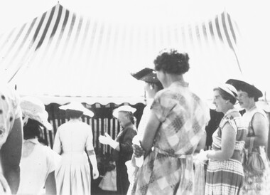
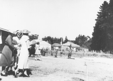
Photograph, Official opening of Greenwood Park Kindergarten, Greenwood Avenue, Ringwood, on a hot 10th December 1955, a day on which the temperature reached 104 degrees
Typed below photograph, "4. Onlookers at opening - Heat 104'" -
 Ringwood and District Historical Society
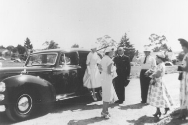
Photograph, Official opening of Greenwood Park Kindergarten, Greenwood Avenue, Ringwood on 10th December 1955. Lady Brooks being escorted to her car by Mrs. E.V. Pullin and Mrs. Jess Anderson
Typed below photograph, "6. Lady Brooks being escorted to her car - Mrs. E.V. Pullin and Mrs. Jess Anderson". -
 Ringwood and District Historical Society
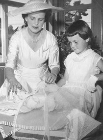
Photograph, Official opening of Greenwood Park Kindergarten, Greenwood Avenue, Ringwood on 10th December 1955. Lady Brooks in "Dollies' Corner" with Barbara Horn
Typed below photograph, "1955 Official opening - Lady Brooks in Dollies' Corner with Barbara Horn". -
 Ringwood and District Historical Society
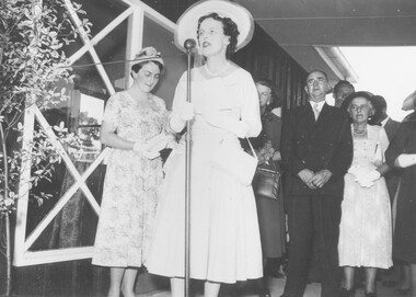
Photograph, Official opening of Greenwood Park Kindergarten, Greenwood Avenue, Ringwood on 10th December 1955. Arrival of Lady Violet Brooks, wife of the Governor of Victoria Sir Dallas Brooks, being greeted by Mrs. Helen Austin"
Typed below photograph, "Official opening Greenwood Park Kindergarten, 10th December 1955. 1. Arrival Lady Violet Brooks, wife of the Governor of Victoria Sir Dallas Brooks, being greeted by Mrs. Helen Austin". -
 Ringwood and District Historical Society
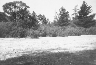
Photograph, Former antimony mine site - 1963, prior to becoming site of Maroondah Civic Centre, Braeside Avenue, Ringwood - 1963
Catalogue card reads, "Mine site, 1963. Site of Civic Centre". -
 Ringwood and District Historical Society
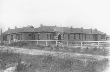
Photograph, Ringwood State School, Greenwood Avenue, Ringwood, on completion - 1922. Site was 3 1/2 acres of Count von Hariss' orchard. Land bought from A. Greenwood MLA"
Typed below photograph, "Ringwood State School - Greenwood Avenue on completion - 1922". Written on back of photograph, "1922 - Site was 3 1/2 acres of Count von Hariss(?) orchard. Land bought from A. Greenwood MLA". Identical framed photograph located in bookshelves -NWD 01-02-03 -
 Ringwood and District Historical Society
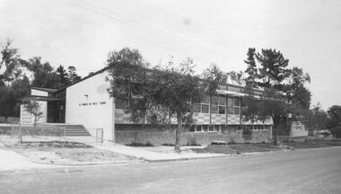
Photograph, Saint Francis De Sales church and school, corner Patterson Street and Bona Avenue, Ringwood East - 1973
Typed below photograph, "Roman Catholic Church and School, Ringwood East, 1973". -
 Ringwood and District Historical Society
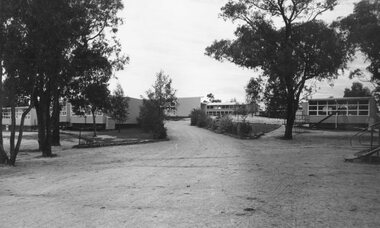
Photograph, Heathmont State School, Balfour Avenue, 1973
Written on backing sheet, "Heathmont State School - 1973". -
 Ringwood and District Historical Society
Photographs, 1977 photographs of Ringwood railway station and surrounding areas
629_001.jpg - Sept 1977 photo of Station St, corner of Greenwood Avenue 629_002.jpg - Sept 1977 photo of railway line looking north to Alan Coffey Motors 629_003.jpg - Sept 1977 photo of Ringwood railway station showing southern carpark -
 Ringwood and District Historical Society
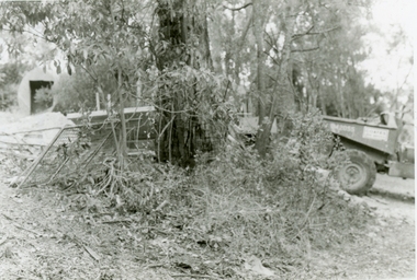
Photographs, 1979-80 MMBW pipe line project at Hubbard Reserve, North Ringwood � Boring mole pit
E560 N5 Dec 1979 A43 Boring mole pit near big box tree in 39 Burlock Avenue backyard Part of a 43-photo record of the MMBW�s engineering feat in drilling a 12 inch pipe line up to 40 feet deep through rock hardened by volcanic action associated with geological fault that occurs along the line. The work took place from October 1979 to May 1980 on the southern boundary of Hubbard Reserve, North Ringwood. The collection was presented to the Ringwood Historical Research Group by J Clarke on 9th June 1980. -
 Ringwood and District Historical Society
Photographs, 1979-80 MMBW pipe line project at Hubbard Reserve, North Ringwood � Back-hoe at pit
E560 N6 Dec 1979 A43 The back-hoe works on the beginnings of pit in 39 Burlock Avenue backyard Part of a 43-photo record of the MMBW�s engineering feat in drilling a 12 inch pipe line up to 40 feet deep through rock hardened by volcanic action associated with geological fault that occurs along the line. The work took place from October 1979 to May 1980 on the southern boundary of Hubbard Reserve, North Ringwood. The collection was presented to the Ringwood Historical Research Group by J Clarke on 9th June 1980. -
 Ringwood and District Historical Society
Photographs, 1979-80 MMBW pipe line project at Hubbard Reserve, North Ringwood � Cover of mole pit
E560 N24 Jan 1980 A43 Cover of mole pit near big box tree in 39 Burlock Avenue backyard Part of a 43-photo record of the MMBW�s engineering feat in drilling a 12 inch pipe line up to 40 feet deep through rock hardened by volcanic action associated with geological fault that occurs along the line. The work took place from October 1979 to May 1980 on the southern boundary of Hubbard Reserve, North Ringwood. The collection was presented to the Ringwood Historical Research Group by J Clarke on 9th June 1980. -
 Ringwood and District Historical Society
Photographs, 1979-80 MMBW pipe line project at Hubbard Reserve, North Ringwood � Compressor unit in backyard
Part of a 43-photo record of the MMBW�s engineering feat in drilling a 12 inch pipe line up to 40 feet deep through rock hardened by volcanic action associated with geological fault that occurs along the line. The work took place from October 1979 to May 1980 on the southern boundary of Hubbard Reserve, North Ringwood. The collection was presented to the Ringwood Historical Research Group by J Clarke on 9th June 1980.E560 N23 Jan 1980 A43 Compressor unit in backyard of 39 Burlock Avenue -
 Ringwood and District Historical Society
Photographs, 1979-80 MMBW pipe line project at Hubbard Reserve, North Ringwood � Work on boring mole pit
Part of a 43-photo record of the MMBW�s engineering feat in drilling a 12 inch pipe line up to 40 feet deep through rock hardened by volcanic action associated with geological fault that occurs along the line. The work took place from October 1979 to May 1980 on the southern boundary of Hubbard Reserve, North Ringwood. The collection was presented to the Ringwood Historical Research Group by J Clarke on 9th June 1980.E560 N22Jan 1980 A43 Work on mole boring pit in 39 Burlock Avenue backyard -
 Ringwood and District Historical Society
Photographs, 1979-80 MMBW pipe line project at Hubbard Reserve, North Ringwood � Filling at 29 Burlock Avenue
Part of a 43-photo record of the MMBW�s engineering feat in drilling a 12 inch pipe line up to 40 feet deep through rock hardened by volcanic action associated with geological fault that occurs along the line. The work took place from October 1979 to May 1980 on the southern boundary of Hubbard Reserve, North Ringwood. The collection was presented to the Ringwood Historical Research Group by J Clarke on 9th June 1980.E560 N10 Dec 1979 A43 Filling at 29 Burlock Avenue -
 Ringwood and District Historical Society
Photographs, 1979-80 MMBW pipe line project at Hubbard Reserve, North Ringwood � Filling behind 29 Burlock Avenue just off sewer line
Part of a 43-photo record of the MMBW�s engineering feat in drilling a 12 inch pipe line up to 40 feet deep through rock hardened by volcanic action associated with geological fault that occurs along the line. The work took place from October 1979 to May 1980 on the southern boundary of Hubbard Reserve, North Ringwood. The collection was presented to the Ringwood Historical Research Group by J Clarke on 9th June 1980.E560 N9 Dec 1979 A43 Filling behind 29 Burlock Avenue just off sewer line -
 Ringwood and District Historical Society
Photographs, 1979-80 MMBW pipe line project at Hubbard Reserve, North Ringwood � Filling at 29 Burlock Avenue
Part of a 43-photo record of the MMBW�s engineering feat in drilling a 12 inch pipe line up to 40 feet deep through rock hardened by volcanic action associated with geological fault that occurs along the line. The work took place from October 1979 to May 1980 on the southern boundary of Hubbard Reserve, North Ringwood. The collection was presented to the Ringwood Historical Research Group by J Clarke on 9th June 1980.E560 N11 Dec 1979 A43 Filling at 29 Burlock Avenue -
 Ringwood and District Historical Society
Photographs, 1979-80 MMBW pipe line project at Hubbard Reserve, North Ringwood � Grating over hole in Chalkley's 41 Burlock Avenue
Part of a 43-photo record of the MMBW�s engineering feat in drilling a 12 inch pipe line up to 40 feet deep through rock hardened by volcanic action associated with geological fault that occurs along the line. The work took place from October 1979 to May 1980 on the southern boundary of Hubbard Reserve, North Ringwood. The collection was presented to the Ringwood Historical Research Group by J Clarke on 9th June 1980.E560 N25 Jan 1980 A43 Grating over hole 37 feet deep in Chalkley's 41 Burlock Avenue (lot 8) -
 Ringwood and District Historical Society
Photographs, 1979-80 MMBW pipe line project at Hubbard Reserve, North Ringwood � Truck-mounted posthole digger that tried to sink shafts on MMBW sewer line behind 29-39 Burlock Avenue
Part of a 43-photo record of the MMBW�s engineering feat in drilling a 12 inch pipe line up to 40 feet deep through rock hardened by volcanic action associated with geological fault that occurs along the line. The work took place from October 1979 to May 1980 on the southern boundary of Hubbard Reserve, North Ringwood. The collection was presented to the Ringwood Historical Research Group by J Clarke on 9th June 1980.E560 N32 Feb 1980 A43 Truck-mounted posthole digger that tried to sink shafts on MMBW sewer line behind 29-39 Burlock Avenue. Four feet wide, the auger could only go down one metre and was nearly useless. -
 Ringwood and District Historical Society
Photographs, 1979-80 MMBW pipe line project at Hubbard Reserve, North Ringwood � View behind no. 39 Burlock Avenue showing compressor, mole pit cover and the big box tree
Part of a 43-photo record of the MMBW�s engineering feat in drilling a 12 inch pipe line up to 40 feet deep through rock hardened by volcanic action associated with geological fault that occurs along the line. The work took place from October 1979 to May 1980 on the southern boundary of Hubbard Reserve, North Ringwood. The collection was presented to the Ringwood Historical Research Group by J Clarke on 9th June 1980.E560 N26 Jan 1980 A43 View behind no. 39 Burlock Avenue showing compressor, mole pit cover and the big box tree -
 Ringwood and District Historical Society
Photographs, 1979-80 MMBW pipe line project at Hubbard Reserve, North Ringwood � Swivel crane over first hole west of boring pit in 39 Burlock Avenue
Part of a 43-photo record of the MMBW�s engineering feat in drilling a 12 inch pipe line up to 40 feet deep through rock hardened by volcanic action associated with geological fault that occurs along the line. The work took place from October 1979 to May 1980 on the southern boundary of Hubbard Reserve, North Ringwood. The collection was presented to the Ringwood Historical Research Group by J Clarke on 9th June 1980.E561 N3 Feb 1980 A43 Swivel crane over first hole west of boring pit in 39 Burlock Avenue. The track used to reach Burlock Avenue on left. -
 Ringwood and District Historical Society
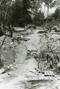
Photographs, 1979-80 MMBW pipe line project at Hubbard Reserve, North Ringwood � Tunnel shafts
Part of a 43-photo record of the MMBW�s engineering feat in drilling a 12 inch pipe line up to 40 feet deep through rock hardened by volcanic action associated with geological fault that occurs along the line. The work took place from October 1979 to May 1980 on the southern boundary of Hubbard Reserve, North Ringwood. The collection was presented to the Ringwood Historical Research Group by J Clarke on 9th June 1980.E561 N12 Feb 1980 A43 Line of tunnel shafts at 29-30 Burlock Avenue showing swivel cranes 5 and 6 from the bore-hole in Lot 7 -
 Ringwood and District Historical Society
Photographs, 1979-80 MMBW pipe line project at Hubbard Reserve, North Ringwood � Sewer tunnel
Part of a 43-photo record of the MMBW�s engineering feat in drilling a 12 inch pipe line up to 40 feet deep through rock hardened by volcanic action associated with geological fault that occurs along the line. The work took place from October 1979 to May 1980 on the southern boundary of Hubbard Reserve, North Ringwood. The collection was presented to the Ringwood Historical Research Group by J Clarke on 9th June 1980.E561 N7 Feb 1980 A43 Work on sewer tunnel below Burlock Avenue. Line of shafts running from manhole in gully to the consecutive groups on top left. -
 Ringwood and District Historical Society
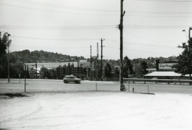
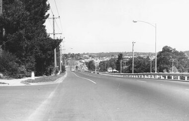
Photograph, Maroondah Highway East, Ringwood- 1973. Westward view from Braeside Avenue along Maroondah Highway
Black and white photographWritten on rear of backing sheet: "Ringwood from Braeside Av. 9/73". -
 Ringwood and District Historical Society
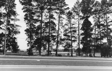
Photograph, Croydon West High School off Cutts Avenue and Maroondah Hwy, Ringwood - November, 1969
Written on backing sheet, "West Croydon School (In Ringwood municipality)". November 1969. The area behind the pine trees was used as a training ground by the Wilhelmina Soccer Club, later called Ringwood City SC and Ringwood FC. It was later sub-divided and the two streets named Wilhelmina and Juliana Courts, in honor of Wilhelmina, Queen of the Netherlands, and her daughter, Juliana, later succeeding her as Queen. The Burnt Bridge Shopping Centre can be seen in the far west on one of the images. -
 Ringwood and District Historical Society
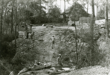
Photographs, 1979-80 MMBW pipe line project at Hubbard Reserve, North Ringwood � The new trach goes on down to Debbie Place
Part of a 43-photo record of the MMBW�s engineering feat in drilling a 12 inch pipe line up to 40 feet deep through rock hardened by volcanic action associated with geological fault that occurs along the line. The work took place from October 1979 to May 1980 on the southern boundary of Hubbard Reserve, North Ringwood. The collection was presented to the Ringwood Historical Research Group by J Clarke on 9th June 1980.E566 N13 13 May 1980 A43 The parting of the ways. My old track goes left to Burlock Avenue. The new way goes on down to Debbie Place.