Showing 836 items
matching parish map
-
 Bendigo Historical Society Inc.
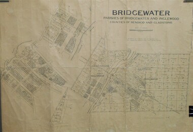
Map - JACK FLYNN COLLECTION: BRIDGEWATER, 10/09/1931
... Map: Bridgewater, Parishes of Bridgewater and Inglewood... Bendigo parish plan Bridgewater Inglewood Map: Bridgewater ...Map: Bridgewater, Parishes of Bridgewater and Inglewood, Counties of Bendigo and Gladstone. Parish plan.map, bendigo, parish plan, bridgewater inglewood -
 Bendigo Historical Society Inc.
Map - PARISH OF EGERTON, 19/03/1894
... Map: Parish of Egerton, Settlement on Lands Act 1893... act 1893. Map: Parish of Egerton, Settlement on Lands Act 1893 ...Map: Parish of Egerton, Settlement on Lands Act 1893, County of Bendigo. Parish plan ( number 245 in Map Cupboard 1)map, bendigo, settlement on lands act 1893, egerton, settlement on lands act 1893. -
Bendigo Historical Society Inc.
Map - SANDHURST (PART), Circa 1880's
... Map: Parish plan showing an area from McKenzie/View streets... Gully Map: Parish plan showing an area from McKenzie/View ...Map: Parish plan showing an area from McKenzie/View streets to Long Gully ( number 232 in Map Cupboard 1)map, bendigo, parish plan, sandhusrt, mckenzie street , view street, long gully -
Bendigo Historical Society Inc.
Map - PARISH OF MARONG, 24/09/1874
... Map; Parish of Marong ,County of Bendigo. This plan has... Bendigo parish plan Marong Map; Parish of Marong ,County ...Map; Parish of Marong ,County of Bendigo. This plan has been cut and then applied to a different backing. ( number 234 in Map Cupboard 1)map, bendigo, parish plan, marong -
Southern Sherbrooke Historical Society Inc.
Information folder - Lysterfield
... , part of parish map of Scoresby, showing holdings in Lysterfield... and the Lysterfield Valley", 2 pages -map, part of parish map of Scoresby ...Information folder containing items pertaining to the history of Lysterfield. Contents: -Articles copied from Knox HS newsletter, inc. Lysterfield, Lysterfield Road, -typescript, "Early settlement of the district later known as Lysterfield", 5 pages -typesccript, "William Lyster and the Lysterfield Valley", 2 pages -map, part of parish map of Scoresby, showing holdings in Lysterfield -illustrations, "A Victorian Model Farm: Nareewarran Grange" -illustration, The Homestead (Nareewarran Grange), 2 copies -copy, 'The Golden Age Of Australian Opera', Chapter 7, an account of William Lyster at Lysterfieldwilliam lyster, lysterfield, nareewarran grange -
Bendigo Historical Society Inc.
Map - CITY OF BENDIGO (PART), Circaa 1900
... Map: parish plan showing an area North West oh Napier St... Bendigo parish plan Bendigo Napier St Weeroona Avenue Map: parish ...Map: parish plan showing an area North West oh Napier St., Weeroona Ave. intersection ( number 216 in Map Cupboard 1)map, bendigo, parish plan, bendigo, napier st, weeroona avenue -
Bendigo Historical Society Inc.
Map - SANDHURST (PART), Circa 1880's
... Map: Parish plan showing a section of the city of Sandhurst... Bendigo parish plan Lloyd St. Sandhurst Bendigo Map: Parish plan ...Map: Parish plan showing a section of the city of Sandhurst, Northwards from Lloyd St. East bendigo. ( number 212 in Map Cupboard 1)map, bendigo, parish plan, lloyd st. sandhurst, bendigo -
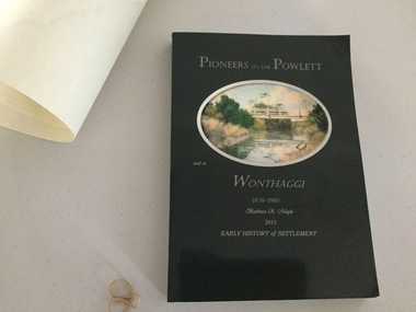 Wonthaggi & District Historical Society
Book and Map, Barbara Moyle, Pioneers on tthe Powlett and at Wonthaggi 1878-1910, 2015
... river and bridge Associated map which covers the parishes plus... R Moyle 2015 Early History of Settlement Map - Parish names... R Moyle 2015 Early History of Settlement Map - Parish names ...Book - families social histories, maps, photograps Map - block numbers town names physical / geographical featuresFarming and social history of pioneers of the Powlett River are prior to the establishment of the State Coal Mine at Wonthaggi. Significant land marks, buildings and photographs are included. Dark green cover with oval artists impression of Powlett river and bridge Associated map which covers the parishes plus key places of interestlPioneers on the Powlett and at Wonthaggi 1878-1910 Barbara R Moyle 2015 Early History of Settlement Map - Parish names, significant sitesfarming, pioneers of wonthaggi and district, wonthaggi families -
Bendigo Historical Society Inc.
Map - RESURVEY, PARISH OF SANDHURST, 1/08/1891
... Map: Resurvey , Parish of Sandhurst sheet 3. Parish plan... Bendigo parish plan Parish of Sandhurst resurvey Map: Resurvey ...Map: Resurvey , Parish of Sandhurst sheet 3. Parish plan ( number 203 in Map Cupboard 1)map, bendigo, parish plan, parish of sandhurst resurvey -
Bendigo Historical Society Inc.
Map - BRIDGEWATER, 10/09/1913
... Map: Bridgewater, Parishes of Bridgewater and Inglewood... Bendigo parish plan Bridgewater Map: Bridgewater, Parishes ...Map: Bridgewater, Parishes of Bridgewater and Inglewood, Counties of Bendigo and Gladstone (number 276 in map cupboard 1)map, bendigo, parish plan, bridgewater -
Bendigo Historical Society Inc.
Map - BENDIGO SHEET 2, No date visible
... Map: Parish plan showing portion of Bendigo city, West from... Bendigo city streets Bendigo sheet 2 bendigo streets Map: Parish ...Map: Parish plan showing portion of Bendigo city, West from the Echuca rail line, showing lake weeroona ( number 136 in Map Cupboard 1)map, bendigo, city streets, bendigo sheet 2, bendigo streets -
Bendigo Historical Society Inc.
Map - SANDHURST (PART), Circa 1880's
... Map: Parish plan covering the area from Belle Vue Rd... Street Short street Map: Parish plan covering the area from Belle ...Map: Parish plan covering the area from Belle Vue Rd. to Barnard St. and Maple St to Short St. ( number 230 in Map Cupboard 1)map, bendigo, parish plan, sandhurst, belle vue road, barnard street, maple street , short street -
Bendigo Historical Society Inc.
Map - BENDIGO (SANDHURST) PART, No date visible
... Map: Parish plan showing an area North West from... Bendigo parish plan Bendigo Long Gully Map: Parish plan showing ...Map: Parish plan showing an area North West from the McKenzie St. View St. corner to Long Gully ( number 220 in Map Cupboard 1)map, bendigo, parish plan, bendigo, long gully -
 Bendigo Historical Society Inc.
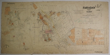
Map - FARADAY, 10/01/1879
... Map: Parish of Faraday, County of Talbot. Parish plan...MAP Talbot parish plan Faraday J. H. Morgan J. T. Thomson ...Map: Parish of Faraday, County of Talbot. Parish plan. Draughtsman J T Thomson December 1877. Examined by J H Morgan 8/11/78map, talbot, parish plan, faraday, j. h. morgan, j. t. thomson -
Stawell Historical Society Inc
Map, Township of Stawell
... , Pleasant Creek Parish of Stawell. Map No L4000..., Pleasant Creek Parish of Stawell. Map No L4000 Township of Stawell ...B/W map of Stawell Surveyed by Easton Johnston Contract surveyor Scale in Chains. Showing Special Allotments Reefs, Pleasant Creek Parish of Stawell. Map No L4000 -
 Bendigo Historical Society Inc.
Map - CAMPBELL COLLECTION: BENDIGO AND DISTRICT MAPS
... Map. Parish of Sandhurst, Parish of Huntly, Parish...MAP Bendigo parishes Map. Parish of Sandhurst, Parish ...Map. Parish of Sandhurst, Parish of Huntly, Parish of Nerring, Parish of Marong, Parish of Lockwood, Parish of Wellsford, Parish of Strathfieldsaye, Parish of Mandurang. Scale approx 1:18,000.map, bendigo, parishes -
Bendigo Historical Society Inc.
Map - LEICHARDT, 23/05/1875
... Map: Parish of Leichardt, County of Bendigo. Parish plan... Bendigo building lots Leichardt Map: Parish of Leichardt, County ...Map: Parish of Leichardt, County of Bendigo. Parish plan (coloured). Attached plan in the top left hand corner marked 'Building Lots' (number 323 in map cupboard 1)map, bendigo, building lots, leichardt -
 Bendigo Historical Society Inc.
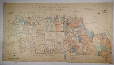
Map - SPRING PLAINS, Examined 31/01/1876
... Map: Parish of Springplains, County of Dalhousie. Parish...MAP Dalhousie parish plan Spring Plains A. D. Scott Map ...Map: Parish of Springplains, County of Dalhousie. Parish plan June 1874 A.D. Scott Examined E.D. 4.7.74 Additions made March 1877 Written in blue " See new plan."map, dalhousie, parish plan, spring plains, a. d. scott -
 Bendigo Historical Society Inc.
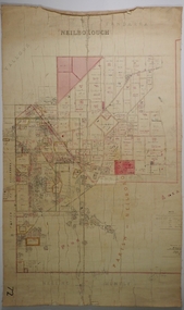
Map - NEILBOROUGH, 21/01/1875
... Map: Parish of Neilborough, County of Bendigo. Hand...MAP Bendigo parish plan Neilborough G. Black W.A. Taylor ...Map: Parish of Neilborough, County of Bendigo. Hand draughted Parish plan. Resurveyed by Mr Assistant-Surveyor G Black. Drawn by W A Taylor. Map dated 21/1/1875.map, bendigo, parish plan, neilborough, g. black, w.a. taylor -
Bendigo Historical Society Inc.
Map - CAMPBELL COLLECTION: BENDIGO AND DISTRICT MAPS
... Map. Sedgwick. Parishes of Strathfieldsaye, Lyell... Bendigo agricultural lands Map. Sedgwick. Parishes ...Map. Sedgwick. Parishes of Strathfieldsaye, Lyell and Sedgwick. Scale 20 chains to 1 inch. (number 359 in map cupboard 1)map, bendigo, agricultural lands -
Bendigo Historical Society Inc.
Map - CAMPBELL COLLECTION: BENDIGO AND DISTRICT MAPS
... Map. Lyell, Parishes of Sedgwick, Eppalock and Lyell. Scale... Bendigo agricultural lands Map. Lyell, Parishes of Sedgwick ...Map. Lyell, Parishes of Sedgwick, Eppalock and Lyell. Scale 20 chains to 1 inch. (number 348 in map cupboard 1)map, bendigo, agricultural lands -
Bendigo Historical Society Inc.
Map - BENDIGO SHEET 3
... Map: copy of Parish plan, canvas backed. Map shows Bendigo... Bendigo city streets Bendigo city streets Map: copy of Parish plan ...Map: copy of Parish plan, canvas backed. Map shows Bendigo city streets. ( number 126 in Map Cupboard 1)map, bendigo, city streets, bendigo, city streets -
Southern Sherbrooke Historical Society Inc.
Information Folder - Len Jeffery
... , undated -photocopies (2), parish map (part) -photocopy part... (2), parish map (part) -photocopy part of allotments ...Information folder containing items pertaining to Len Jeffery. Contents: -handwritten notes by Elaine Cordell, dated 2017 -letter, Peter & Ruth Jeffery, to Phil Garland, dated 25 June 2011 -letter, Peter & June Jeffery to Elaine Cordell, dated 26 July 2011 -photocopy, A4, of photo featuring Thomas & Henry Jeffery -photocopies of death notice and short obituary, undated -photocopies (2), parish map (part) -photocopy part of allotments in Parish of Narree Worran with attached newspaper clipping -photocopy of hand-drawn map of blocks in Belgrave Heights -magazine "Yarra Valley & Ranges country life", Issue 7 Winter 2011, featuring article about Peter Jeffery, Len Jeffery's nephewlennox jeffrey, peter jeffery, belgrave heights progress association -
Bendigo Historical Society Inc.
Map - RESURVEY PARISH OF SANDHURST, 23/07/1891
... Map: Resurvey, Parish of Sandhhurst sheet No. IV... Bendigo parish plan Parish of Sandhurst Resurvey Map: Resurvey ...Map: Resurvey, Parish of Sandhhurst sheet No. IV, Enlargement of part of sheet No. III. Parish plan ( number 204 in Map Cupboard 1)map, bendigo, parish plan, parish of sandhurst, resurvey -
 Bendigo Historical Society Inc.
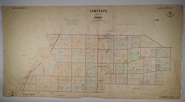
Map - PARISH OF CAMPASPE, November 1880
... Map: Parish of Campaspe, County of Rodney. Parish plan...MAP Rodney parish plan Campaspe Map: Parish of Campaspe ...Map: Parish of Campaspe, County of Rodney. Parish plan G.H.H. Smith Draughtsman August 1880 Examined J.A. Morrison 7.10.80 Photo- Lithographed J. Noone. 1.11.80 Written in green " Cancelled 16.2.66."map, rodney, parish plan, campaspe -
Bendigo Historical Society Inc.
Map - HUNTLY ? (NO NAME ON PLAN), Circa 1876
... Map: Huntly?. Hand Draughted parish plan. Originally in Map... Bendigo parish plan Huntly Map: Huntly?. Hand Draughted parish ...Map: Huntly?. Hand Draughted parish plan. Originally in Map Cupboard. Relocated to Map Drawer 5 on 22.9.22. Too long for the map cupboard.map, bendigo, parish plan, huntly -
Bendigo Historical Society Inc.
Map - PART OF ELLESMERE, 20/06/1875
... Map: Re-survey of part of the Parish of Ellesmere, hand... Bendigo parish plan Ellesmere Map: Re-survey of part of the Parish ...Map: Re-survey of part of the Parish of Ellesmere, hand draughted Parish plan Reloacated to Map Drawer 5 on 22.9.2022. Hanging strip detached.map, bendigo, parish plan, ellesmere -
Bendigo Historical Society Inc.
Map - CAMPBELL COLLECTION: BENDIGO AND DISTRICT MAPS, 11-2-37
... Map. Parish of Shelbourne, County of Bendigo. Scale 40... Inc. History House 11 Mackenzie Street Bendigo goldfields MAP ...Map. Parish of Shelbourne, County of Bendigo. Scale 40 chains to 1 inch. Drawn and reproduced at the Department of Lands and Survey, Melbourne, Victoria. Price 2/-.11-2-37. By Authority H.J. Green, Government Printer, Melbourne.H.J. Green, Government Printermap, bendigo, agricultural lands -
Bendigo Historical Society Inc.
Map - CAMPBELL COLLECTION: BENDIGO AND DISTRICT MAPS
... Map. Mandurang, Parish of Mandurang. Scale 20 chains to 1... Bendigo allotments Map. Mandurang, Parish of Mandurang. Scale 20 ...Map. Mandurang, Parish of Mandurang. Scale 20 chains to 1 inch. Total area 5993 acres. Northern Railway. (number 395 in map cupboard 1)map, bendigo, allotments -
Bendigo Historical Society Inc.
Map - CAMPBELL COLLECTION: BENDIGO AND DISTRICT MAPS
... Map. Lyell, Parishes of Sedgwick, Eppalock and Lyell. Scale... Bendigo country lands Map. Lyell, Parishes of Sedgwick, Eppalock ...Map. Lyell, Parishes of Sedgwick, Eppalock and Lyell. Scale 20 chains to 1 inch. Total area 3307 acres. (number 387 in map cupboard 1)map, bendigo, country lands