Showing 2288 items matching "parishes"
-
 Warrnambool and District Historical Society Inc.
Map, Department of Lands and Survey (Lithographers), Caramut township, 1938
This map of the township of Caramut was produced in 1938 but shows the original land owners of each town allotment and of the surrounding area. The size of all the allotments and the date of the original purchase are also shown. Caramut is a Victorian Western District town on Mustons Creek on the Hamilton Highway 48 kilometres from Warrnambool. This map was used by Rolf Crawley when he was the engineer for the Shire of Warrnambool from 1935 to 1968. The annotations on the map have probably been made by Rolf Crawley as they refer to the records and letter books of his father, John William Crawley, Junior (Shire of Warrnambool Engineer 1895 to 1935). Both Rolf Crawley and his father, John had private businesses as architects, surveyors and engineers and the map could have been used in connection with both their official Shire duties and their private businesses. The last owner of the map was the surveyor, Michael Hand who took over the business of Rolf Crawley in the late 1960s. This map is of great interest firstly because it has all the historical details of the land first purchased in the town of Caramut and area and secondly because it came from the office of Rolf Crawley, the engineer for the Shire of Warrnambool from 1935 to 1968. This is a buff-coloured paper map with a cloth backing. The map details are in black and white print. There are some handwritten red and black annotations on the map. “Town of Caramut Parish of Caramut County of Villiers’town of caramut, john william crawley junior, warrnambool, rolf crawley, warrnambool -
 Eltham District Historical Society Inc
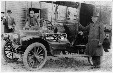
Negative - Photograph, The Roman Catholic Parish Priest, Eltham, c.1908
Man in top hat standing beside the car is most probably the Reverend John P. Carney (born 1880 Ballaghaderreen, Country Mayo, Ireland - ordained at All Hallows College, Dublin, Ireland) who spent all his years as a priest in the Melbourne Archdiocese, arriving in Melbourne in 1902. He was appointed Assistant priest at St Francis Melbourne then at Castlemaine and Gordon. He left Gordon to the pastor of the new mission at Diamond Creek where he spent about five years before moving to Footscray and later Yarraville. The automobile has been identified as a Unic Taxi built in the United Kingdom about 1908 though the actual date of this particular vehicle is unclear. The registration number 7788 was issued prior to 1910 at which point they changed to numerals only of the form nnn-nnn. Reproduced on p93 of 'Pioneers & Painters'.This photo forms part of a collection of photographs gathered by the Shire of Eltham for their centenary project book,"Pioneers and Painters: 100 years of the Shire of Eltham" by Alan Marshall (1971). The collection of over 500 images is held in partnership between Eltham District Historical Society and Yarra Plenty Regional Library (Eltham Library) and is now formally known as 'The Shire of Eltham Pioneers Photograph Collection'. It is significant in being the first community sourced collection representing the places and people of the Shire's first one hundred years.Digital image 120 format B&W negative Original sepia coloured postcard (10 x 15 cm) with cracking Black and white photograph duplicate (16.5 x 25 cm) with some corrections to mask cracksInscribed on reverse 'R.C. Parish Priest, Eltham'sepp, shire of eltham pioneers photograph collection, parish priest, automobile, john p carney, diamond creek, unic taxi, pioneers and painters, eltham, motor vehicles, rev. john p carney -
 Port Melbourne Historical & Preservation Society
Map - Footscray, Public Lands Office, 19 Oct 1857
Map of Footscray, west of Saltwater Creek; south of Hopkins Street, east of Railway and north southern boundary of Botanical Garden reserve.The Township of Footscray, Parish of Cut-Paw-Pawfootscray -
Stawell Historical Society Inc
Map - Subdivision map, Subdivision of North Woodlands Estate Map
Shows Homestead Cottage and Dam, Plus Shed. Malakoff NavarreA3 photocopy of MapParishes of Malakoff and Navarre. County of Kara karasurvey -
 Running Rabbits Military Museum operated by the Upwey Belgrave RSL Sub Branch
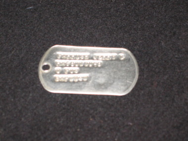
ID Tags
Jerry L Parish RA68012058equipment, 1964, ran -
Stawell Historical Society Inc
Map - Parish Map, Barkley County of Kara Kara 1920's, 1920's ?
Johnsons Gully LeadPaper map of Parish of BarkelyBy Authority H.J. Green Govt Printer. Photo Lithographed at the Department of Lands and Survey. Melbourne 22.11.2survey -
Stawell Historical Society Inc
Map, Parish of Stawell, Sheet 3, 1958
Parish of Stawell, Sheet 3stawell -
Stawell Historical Society Inc
Map, Parish of Stawell, Sheet 1
Parish of Stawell, Sheet 1stawell -
Stawell Historical Society Inc
Map, Parish of Stawell, Sheet 2, 1958
Parish of Stawell, Sheet 2stawell -
Stawell Historical Society Inc
Map, Parish of Stawell, Sheet 3, 1958
Parish of Stawell, Sheet 3stawell -
Stawell Historical Society Inc
Map, Parish of Stawell, Sheet 4, 1958
Parish of Stawell, Sheet 4stawell -
Stawell Historical Society Inc
Map, Parish of Stawell, Sheet 5, 1958
Parish of Stawell, Sheet 5stawell -
Stawell Historical Society Inc
Map, Parish of Mokepilly, County of Borung
Parish of Mokepilly, County of Borungstawell -
Whitehorse Historical Society Inc.
Map, Melbourne Geological Map, 1937
Geological Map of Melbourne & Suburbs.Geological Map of Melbourne & Suburbs. Scale: 40 chains to 1 inch with inset 10 miles to 1 inch. Includes Municipal and Parish boundaries, railways and stations, electric tramways, cable tramways, Post Offices and State schools. Area bounded by Braybrook, Preston, Blackburn & Brighton. Printed on linen.Geological Map of Melbourne & Suburbs. melbourne, maps -
 Ringwood and District Historical Society
Map, Department of Mines, Plan of area applied for under the mining leases regulations in the township of Ringwood between Maroondah Highway and Mt. Dandenong Road. Mining District of Castlemaine, County of Mornington, Parish of Ringwood T Area 58(A) 2 (R)15(P) Acres, Roods, Perches. 1934, 20-Feb-34
Map of the township of Ringwood with subdivisions between Maroondah Highway and Mt. Dandenong Road. the area applied for on lease No.8210 by E.G.Browne.Mining District of Castlemaine, County of Mornington, Parish of Ringwood T Area 58(A) 2 (R)15(P) Acres, Roods, Perches.Buff coloured sheet foolscap with black printing showing map of the township of Ringwood between Maroondah Highway and Mt. Dandenong Road. Mining District of Castlemaine, County of Mornington, Parish of Ringwood T Area 58(A) 2 (R)15(P) Acres, Roods, Perches +Additional Keywords: Browne E.G. -
 Surrey Hills Historical Society Collection
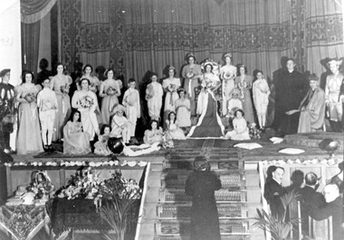
Photograph, Holy Redeemer Queen Carnival, 1938, 1938
Donor identifies the following: Parish priest - Dr W M Collins Queen - Molly Baker Attendants - Marg Wise, Lola Sans, Gertie Baker Flower girls - Madge Wise, Molly Brown, Rita O'Sullivan Probably taken in Our Holy Redeemer Hall, Mont Albert Road, Surrey Hills.This is one of only a few photos in our collection which are evidence of Queen Carnivals which originated as fundraising events. They were particularly popular in both Australian and New Zealand during the early 20th century. They were particularly common during and after World War I when they were used to raise funds for returned soldiers. It is currently the only photo in the collection of a social event connected to Our Holy Redeemer Church and the only one which includes Dr William M Collins who was the parish priest from 1933-1941. Dr Collins was a significant figure in the Catholic Church in Melbourne in the first half of the 20th century. REF: The Advocate: The first priest-editor by Fiona Power; Kairos Catholic Journal Volume 22, Issue 16. - 2 September 2011": Summary: Born in Kilmore in 1884, William Collins attended South Melbourne College and then the University of Melbourne, where he assisted in the formation of the Newman Society of Victoria. After graduating in arts in 1911, he worked at the Melbourne Public Library and the Education Department. In 1912, at the age of 28, he went to Rome, where he studied for the priesthood at Urban College. He obtained doctorates in philosophy and theology and was ordained on 3 June 1917. He returned to Melbourne and was appointed curate at St Mary’s, West Melbourne, and St Francis’, Lonsdale Street. In 1918, Dr Collins became editor of The Advocate. He remained in the role for seven years. Dr Collins was parish priest of Dandenong, Daylesford, East Malvern, Surrey Hills and Kew, and administrator at St Francis’. He died in 1959 and a Requiem Mass was held at Sacred Heart, Kew. Black and white photo of the participants in the Queen Carnival arranged on a stage in a tableaux of the coronation of the Queen. To the right are the parish priest and the archbishop and there is a man at the bottom of the stairs centre front of the stage. Guests are seated at a table to the right of the stairs and to the left of the stairs is a table with floral arrangements and other objects. "1938" hand-written on the original photo in upper LH corner.festivals and celebrations, queen carnivals, our holy redeemer church, dr w m collins, rev william m collins, (miss) molly baker, (miss) marg wise, (miss) lola sans, (miss) gertie baker, (miss) madge wise, (miss) molly brown, (miss) rita o'sullivan -
![Map, Plan of Subdivision of Crown Portion 23 & parts 24-25, Parish of Korkuperrimul [1900s?]](/media/collectors/5e461d8021ea67224c82f2a1/items/675fe058304668462205d4fb/item-media/675fe0ef304668462205d7d6/item-fit-380x285.jpg) Bacchus Marsh & District Historical Society
Bacchus Marsh & District Historical SocietyMap, Plan of Subdivision of Crown Portion 23 & parts 24-25, Parish of Korkuperrimul [1900s?]
The Parish of Korkuperrimul includes a significant section of the township of Bacchus Marsh and extends in western and northern directions from the township area. The date of the subdivision indicated on this plan has not been established. The engineer's stamp on the drawing shows the firm of Muntz and Muntz who were operating under that name in the early part of the 20th century.A single page paper map showing 20 blocks of land for sale in the Parish of Korkuperrimul. Scale 100 feet to 1 inch. The map is pasted into a bound volume containing 76 maps or plans in total. High resolution digital image stored on BMDHS computer network. Stamped: 'Muntz & Muntz Civil Engineers, Architects & Surveyors, Trustees Chambers ?? Cor Collins Street and Bank Placeland sales bacchus marsh, bacchus marsh victoria maps, land sales korkuperrimul parish -
 Bendigo Historical Society Inc.
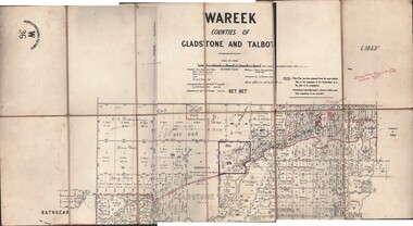
Map - JACK FLYNN COLLECTION: WAREEK, Examined 1918
Map: L.1053. Parish of Wareek, Counties of Gladstone and Talbot. Parish plan. Looks like half of the sheet is missing.Second Issue. Examined by S.F. Green. July 1918. William J. Swan, Draughtsman, August 1884. Photo-Lithographic Fac-Simile, W 36.map, gladstone, parish plan, wareek -
Bendigo Historical Society Inc.
Map - TOWNSHIP OF KANGAROO FLAT, 27/01/1932
Map: Township of Kangaroo flat, Parish of Sandhurst , County of Bendigo. Parish plan ( number 194 in Map Cupboard 1)map, bendigo, township, kangaroo flat -
Bendigo Historical Society Inc.
Map - BOROUGH OF EAGLEHAWK, 30/11/1931
Map: Borough of Eagle hawk, Parish of Nerring. Parish plan with coloured areas ( number 185 in Map Cupboard 1)map, bendigo, parish plan, borough of eaglehawk, parish of nerring -
Bendigo Historical Society Inc.
Map - TOWNSHIP OF HEATHCOTE (PART), 11/04/1935
Map: Township of Heathcote (part), Parish of Heathcote, County of Dalhousie. Parish plan (number 259 in map cupboard 1)map, dalhousie, township, heathcote, copunty of dalhousie -
Bendigo Historical Society Inc.
Map - HUNTLY (PART) RESURVEY, Circa 1877
Map: Huntly [part) resurvey, Parish of Huntly, County of Bendigo. Parish plan ( number 243 in Map Cupboard 1)map, bendigo, parish plan, huntly -
Bendigo Historical Society Inc.
Map - PARISH OF EPPALOCK RESURVEY, 23/05/1876
Map: Parish of Eppalock resurvey, County of Bendigo, hand draughted Parish plan ( number 240 in Map Cupboard 1)map, bendigo, parish plan, eppalock, resurvey -
Bendigo Historical Society Inc.
Map - WESTON, 21/10/1876
Map: Re-Survey of part of the parish of Weston, County of Rodney. Parish plan (number 309 in map cupboard 1)Murray and Hargreave, Authorised surveyorsmap, rodney, parish plan, parish of weston, murray and hargreave -
Bendigo Historical Society Inc.
Map - GRAZING ALLOTMENTS, 15/10/1894
Map: Grazing Allotments, Parishes of Whirrakee and Bagshot, County of Bendigo. Parish plan (number 331 in map cupboard 1)map, bendigo, grazing allotments, grazing allotments, whirrakee, bagshot -
 Bendigo Historical Society Inc.
Map - EPSOM ?, Circa 1880
Map: Parish plan showing an area Southwards from the parish of Huntly boundary, Covering Epsom,Ascot and White Hillsmap, bendigo, parish plan, epsom, ascot, white hills -
Whitehorse Historical Society Inc.
Map, Plan of special survey selected by H. Elgar Esq, 1841
Photocopy of plan and listing of corner stakes.Photocopy of plan and listing of corner stakes. Note on verso: Plan of special survey selected by H. Elgar Esq in the Parishes of Boroondara and Nunawading, County of Bourke. Surveyed by T.H. Nott (?Sydney) 31 May 1841. Boroondara Special Survey B.17, with attached descriptive note by T. H. Nott.Photocopy of plan and listing of corner stakes. maps, parish of boroondara, parish of nunawading, elgar, h, nott, t.h. -
 St Kilda Historical Society
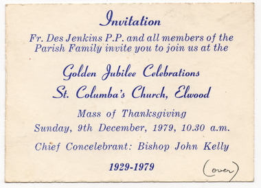
Ephemera - Invitation, Golden Jubilee Celebrations, St Columba's Church, Elwood, 1979
Invitation to a Mass of Thanksgiving in connection with the Golden Jubilee Celebrations of St Columba's Church, Elwood, on 9 December 1979. The St Columba Church and school is on the corner of Glenhuntly Road and Normandy Road, Elwood. The land was purchased in 1914. The school was built and opened first in 1918 and the church was completed and opened in 1929. The church is now part of the Catholic Parish of Sacred Heart and St Columba, serving St Kilda and Elwood communities.White card, discoloured with age, printed in blue on one side. Handwriting on both sides, in blue and blackHandwriting on back in black: Dearest Joan, This is our warm invitation, do hope you can come Mary. Handwriting on back in blue: Please come to the "Back to" in Parish Hall after Mass.churches, st columba's church, elwood -
 Federation University Historical Collection
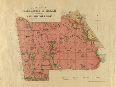
Plan, Bungaree and Dean Parish and Geological Plan, 1890, 07/1890
Ferdinand M. Krause was a Professor at the Ballarat School of Mines.Geological and Parish Map of parts of the Parishes of Bungaree and Dean in the Counties of Talbot, Grenville and Grant. The scale is 40 chains to one inch. bungaree, deen, krause, f.m. krause, musk creek, clarkes hill, badger hill, beale's reservoir, acquainted. -
Bendigo Historical Society Inc.
Map - BENDIGO WEST IRRIGATION SETTLEMENT, 27/07/1910
Map: bendigo West Irrigation Settlement, Parish of Sandhurst, County of Bendigo. Parish plan ( number 193 in Map Cupboard 1)map, bendigo, irrigation settlement, bendigo west irrigation settlement