Showing 314 items matching "parks and environment"
-
 Port Melbourne Historical & Preservation Society
Pamphlet - Beacon Cove to Webb Trail 2016, Pat Grainger, Walks around Vintage Port No.6, Jun 2016
Walks Around Vintage Port No 6. Supported by CoPP. Walk No 6 was originally reserved for Bend on the River: Westgate Park. The Westgate Park walk was not produced so the updated versions the Pub walk in 2001 and 2012 became No 6 however with the introduction of this Beacon Cove to Webb Trail as a new Walk No 6 in 2016, the 2017 version of the Pub walk reverted to No 7.Port Melbourne Historical and Preservation Society publication, "Walks around Vintage Port", No.6 Beacon Cove to Webb Trail 2016 Editionbuilt environment, piers and wharves - webb dock, beacon cove -
 Port Melbourne Historical & Preservation Society
Photograph - Graham Street towards Albert Park, Reverend Donald LANGFORD, June 1973
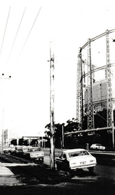
Taken from the corner of Seisman Place looking towards Albert Park, the photograph was taken before the demolition of the gasometer shown on the on right. The original Albert Park High School can be seen behind the Pickles Street sign.B & W photograph of Graham Street, Port Melbourne looking towards Pickles Street.built environment - demolition, built environment - industrial, transport - roads, education - secondary schools, gasometer -
 Port Melbourne Historical & Preservation Society
Photograph - Elevated view to Gasometers & Albert Park High School, Reverend Donald LANGFORD, June 1973
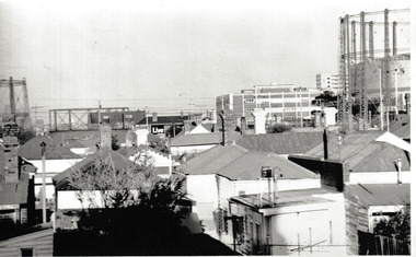
Taken from a vantage point- possibly Holy Trinity Manse -the typical 197'0's Port Melbourne roof lines are the foreground with the still erected gasometers and original Albert Park High School can be seen in the distance.B & W photograph taken before the gasometers were removed & Albert Park High School rebuilt as Albert Park College.June 1973built environment - demolition, built environment - industrial, education - secondary schools, gasometer -
 Port Melbourne Historical & Preservation Society
Photograph, James Lauritz, Parkland and the Beacon, 1989 - 1990
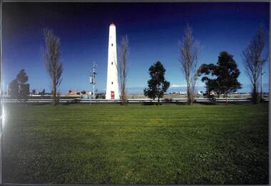
Parkland and the Beacon. A temporary extension to Howe Parade is between the park and the beacon. In the distance the area is cleared and ready for redevelopment James Lauritz print of Port Melbourne, laminated (one of 18). Copies of slides produced for Port Melbourne Councillocal government - city of port melbourne, built environment, james lauritz, beacon cove, beacon -
Port Melbourne Historical & Preservation Society
Document - Contract of Sale for Lot 35 Beacon Cove, Port Melbourne, 1996
Lot 35 is now titled 18 Park Square, Beacon Cove, Port MelbourneWhite folder with black spiral binding & Beacon Cove logo. Folder contains the Contract for Sale of Real Estate for Lot 35 Beacon Cove.built environment - domestic, department of planning and development, park square, beacon cove, mirvac -
Port Melbourne Historical & Preservation Society
Document - Vendors Statement for the sale of Lot 35 Beacon Cove, Port Melbourne, 1996
Lot 35 is now titled 18 Park Square, Beacon Cove, Port MelbourneFolder with pale green cover and black spiral binding. Folder contains Vendors Statement to the Purchaser of Real Estate pursuant to Section 32 of the Sale of Land Act 1962 for Lot 35 Beacon Cove.built environment - domestic, department of planning and development, park square, beacon cove, mirvac -
Port Melbourne Historical & Preservation Society
Document - Welcome to Beacon Cove specifications Manual for Lot 35 Beacon Cove, Port Melbourne, 1996
Lot 35 is now titled 18 Park Square, Beacon Cove, Port MelbourneLarge white folder with blue, yellow & red pattern & Beacon Cove logo. The title 'Welcome to your Beacon Cove Home is in white on blue.built environment - domestic, park square, beacon cove, mirvac -
Port Melbourne Historical & Preservation Society
Film - Video Recording - Digital, Lyn Allison, Westgate Biodiversity, 26 Jul 2022
Digital video recording of PMHPS meeting held on 26 July 2022. Lyn ALLISON is the president of Westgate Biodiversity: Bili Nursery & Land Care who presents an illuminating insight into the workings of Westgate Park, its history & what the future holds. A history of community action in bringing back nature.lyn allison, westgate biodiversity: bili nursery and land care, westgate park, natural environment - conservation -
 Port Melbourne Historical & Preservation Society
Photograph - SSB building with cars c 1950s, Public Records Office Victoria (PROV), 1886 - 1982
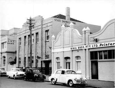
The State Savings Bank building was constructed c1891. Remodeled in 1940sCOPYRIGHT Public records Office Victoria .06 1948 building with cars (incl Holden) parked at front. Also shown are ANZ building to east and Riall Bros on West built environment - commercial, business and traders, transport - motor vehicles, state savings bank of victoria, general motors-holden, gmh -
 Port Melbourne Historical & Preservation Society
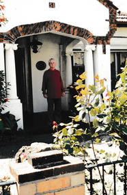
Photograph - 51 Esplanade West Port Melbourne, Janet BOLITHO, c.2006
House built in the inter-war period. Council approved a four 3 storey development with 8 on-site car parks in 2008. It was appealed to VCAT but unsuccessfully and the house was demolished in December 2010. Fire destroyed much of the building prior to ademolition.Colour photograph of Ron in porch at 51 Esplande West, Port Melbourne.built environment - domestic, built environment - demolition, esplanade west -
Port Melbourne Historical & Preservation Society
Photograph - Westgate Park, Nov 2022
Digital image of PMH&PS members visiting Westgate Park, Port Melbourne.built environment - recreational facilities, westgate park -
 Port Melbourne Historical & Preservation Society
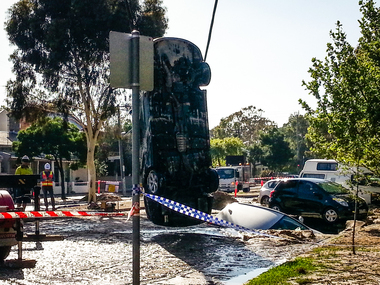
Document - Sink-hole, Liardet Street, Port Melbourne, 17 Dec 2014
In the early hours of Tuesday 16 December, 2014 a water main burst in Liardet St. The resulting sink-hole swallowed two cars and left a massive hole which took 8 days to repair and re-open the road. Several houses on the city side of Liardet St suffered water damage and water also entered the underground car park of the apartment block on the beach side.Photos taken of the damage and vehicle recoveries when a sink-hole opened up on Liardet Street on Tuesday 16 December 2014.built environment - domestic, engineering - roads streets lanes and footpaths, engineering - canals and drainage, liardet street, water supply, fran egan -
Port Melbourne Historical & Preservation Society
Map, City of Port Melbourne, Oct 1963
Gives a visual understanding of the Port Melbourne area in 1963A detailed map of the Port Melbourne area in October 1963. Details roads and laneways, undeground cables, light and power poles, sewer, bridges, piers reserve and park areas.local government, built environment, piers and wharves, natural environment - beaches and foreshore, parks and gardens, piers and wharves - princes pier, piers and wharves - station pier, engineering - roads streets lanes and footpaths, engineering - canals and drainage -
Port Melbourne Historical & Preservation Society
Photograph - Perce White Reserve, Port Melbourne, 1990s
Three photos, origin unknown, of Perce White Reserve. .01 - (landscape) .02 - (portrait) open view into bush .03 - (portrait) dark path into bushNumbers in green on back 22, 23, 20parks and gardens, environment, friends of port melbourne foreshore, perce white reserve, perce mcguire white, perce white -
 Yarra City Council
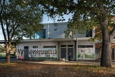
Artwork, other - Mural, Fiona McMonagle, The Park, 2022
... Parks ...'The first panel celebrates the long history of runners that use the park. Richmond Harriers Athletics Club was established in 1913 and is the oldest athletics club in Victoria. The central panel depicts young female footballers and recognises female athletes and the popularity of women and girls' teams in contemporary sports. The final panel depicts a children’s cricket match. The young players are represented through the depiction of a game that is part of our national psyche and firmly entrenched in Australian culture.'Inner-city parks like Citizens Park have many diverse uses. They provide places to play, to exercise and to relax. They are spaces for community and are often subject to competing values and interests. The re-development of the Jack Dyer Pavilion at Citizens Park allows for the growth of the local community’s diverse interests and values and enables participation and interaction. 'The Park' focuses on the recreational uses of Citizens Park and its role as a community space in an area that is changing rapidly. The mural consists of three panels that address inclusivity and access to sport. Three core sporting groups who each utilize the pavilion and park as a public recreational space are represented: children, sport teams and runners. In fostering the representation of these groups, the panels also attest to the past, present, and future of this important space.Three sporting groups are represented: athletics/runners, women footballers in line formation and young cricketers in action/play. Accompanying plaquesport, women, community, richmond, parks -
 St Kilda Historical Society
Photograph - Photo map, 28/01/1951
One of a series of photo-maps produced for the Department of Crown Lands and Survey (1857-1983). For correlation with a current map, and access to other historical photo maps of Victoria, see the Historic Photo-Maps Index published by the Department of Environment, Land, Water and Planning at https://services.land.vic.gov.au/DELWPmaps/historical-photomaps/Black and white aerial photograph1424-45 SECRET 534 Run 18 Lens 12" Melbourne Metropolitan 12150 28.1.51 M639albert park, st kilda junction, st kilda pier, catani gardens, st kilda, prahran, albert park lake, 1951, middle park, st kilda beach, windsor -
 St Kilda Historical Society
Photograph - Photo map, 28/01/1951
One of a series of photo-maps produced for the Department of Crown Lands and Survey (1857-1983). For correlation with a current map, and access to other historical photo maps of Victoria, see the Historic Photo-Maps Index published by the Department of Environment, Land, Water and Planning at https://services.land.vic.gov.au/DELWPmaps/historical-photomaps/Black and white aerial photograph1424-118 534 Run 20 Lens 12" Melbourne Metropolitan 12150 18.1.51M639elwood, point ormond, elwood park, elsternwick park, elwood beach, 1951 -
 St Kilda Historical Society
Photograph - Photo map, 30/01/1960
One of a series of photo-maps produced for the Department of Crown Lands and Survey (1857-1983). For correlation with a current map, and access to other historical photo maps of Victoria, see the Historic Photo-Maps Index published by the Department of Environment, Land, Water and Planning at https://services.land.vic.gov.au/DELWPmaps/historical-photomaps/Black and white aerial photographVic 1093-62 Melbourne & Metropolitan Project Run 21 30.1.60 Lens 10" 8.200middle park, albert park, catani gardens, st kilda west, 1960 -
 St Kilda Historical Society
Photograph - Photo map, 30/01/1960
One of a series of photo-maps produced for the Department of Crown Lands and Survey (1857-1983). For correlation with a current map, and access to other historical photo maps of Victoria, see the Historic Photo-Maps Index published by the Department of Environment, Land, Water and Planning at https://services.land.vic.gov.au/DELWPmaps/historical-photomaps/Black and white aerial photographVic 1093-60 Melbourne & Metropolitan Project Run 21 30.1.60 Lens 10" 8.200st kilda, albert park, prahran, windsor, south yarra, 1960 -
 St Kilda Historical Society
Photograph - Photo map, 30/01/1960
One of a series of photo-maps produced for the Department of Crown Lands and Survey (1857-1983). For correlation with a current map, and access to other historical photo maps of Victoria, see the Historic Photo-Maps Index published by the Department of Environment, Land, Water and Planning at https://services.land.vic.gov.au/DELWPmaps/historical-photomaps/Black and white aerial photographVic 1092-42 Melbourne & Metropolitan Project Run 22 30.1.60 Lens 10" 8.200malvern, caulfield, caulfield park, 1960 -
 St Kilda Historical Society
Photograph - Photo map, 30/01/1960
One of a series of photo-maps produced for the Department of Crown Lands and Survey (1857-1983). For correlation with a current map, and access to other historical photo maps of Victoria, see the Historic Photo-Maps Index published by the Department of Environment, Land, Water and Planning at https://services.land.vic.gov.au/DELWPmaps/historical-photomaps/Black and white aerial photographVic 1091-112 Melbourne & Metropolitan Project Run 23East 30.1.1960 Lens 10" 8.200elwood, point ormond, elwood park, elwood canal, 1960 -
 St Kilda Historical Society
Photograph - Photo map, 30/01/1960
One of a series of photo-maps produced for the Department of Crown Lands and Survey (1857-1983). For correlation with a current map, and access to other historical photo maps of Victoria, see the Historic Photo-Maps Index published by the Department of Environment, Land, Water and Planning at https://services.land.vic.gov.au/DELWPmaps/historical-photomaps/Black and white aerial photographVic 1091-110 Melbourne & Metropolitan Project Run 23East 30.1.60 Lens 10" 8.200elwood, elsternwick, elsternwick park, ripponlea, st kilda east, caulfield, balaclava, 1960 -
 St Kilda Historical Society
Photograph - Photo map, 30/01/1960
One of a series of photo-maps produced for the Department of Crown Lands and Survey (1857-1983). For correlation with a current map, and access to other historical photo maps of Victoria, see the Historic Photo-Maps Index published by the Department of Environment, Land, Water and Planning at https://services.land.vic.gov.au/DELWPmaps/historical-photomaps/Black and white aerial photographVic 1091-1 Melbourne & Metropolitan Project Run 24East 30.1.60 Lens 10" 8.200elwood, elwood beach, elwood park, 1960 -
 St Kilda Historical Society
Photograph - Photo map, 30/01/1960
One of a series of photo-maps produced for the Department of Crown Lands and Survey (1857-1983). For correlation with a current map, and access to other historical photo maps of Victoria, see the Historic Photo-Maps Index published by the Department of Environment, Land, Water and Planning at https://services.land.vic.gov.au/DELWPmaps/historical-photomaps/Black and white aerial photographVic 1091-2 Melbourne & Metropolitan Project Run 24East 30.1.60 Lens 10" 8.200elwood, elwood park, elwood beach, elsternwick park, 1960 -
 St Kilda Historical Society
Photograph - Photo map, 3/3/1964
One of a series of photo-maps produced for the Department of Crown Lands and Survey (1857-1983). For correlation with a current map, and access to other historical photo maps of Victoria, see the Historic Photo-Maps Index published by the Department of Environment, Land, Water and Planning at https://services.land.vic.gov.au/DELWPmaps/historical-photomaps/Black and white aerial photographVic 1833 Melbourne 1963 Project Run 15 3.3.64 Lens 205 152.70 M/M 5.150 56prahran, fawkner park, south yarra, albert park, 1964 -
 St Kilda Historical Society
Photograph - Photo map, 14/12/1963
One of a series of photo-maps produced for the Department of Crown Lands and Survey (1857-1983). For correlation with a current map, and access to other historical photo maps of Victoria, see the Historic Photo-Maps Index published by the Department of Environment, Land, Water and Planning at https://services.land.vic.gov.au/DELWPmaps/historical-photomaps/Black and white aerial photographVic 1807 Melbourne 1963 Project Run 16 14.12.63 Lens 205 152.70 M/M 5.150 179st kilda, prahran, albert park, st kilda east, balaclava, 1963 -
 St Kilda Historical Society
Photograph - Photo map, 14/12/1963
One of a series of photo-maps produced for the Department of Crown Lands and Survey (1857-1983). For correlation with a current map, and access to other historical photo maps of Victoria, see the Historic Photo-Maps Index published by the Department of Environment, Land, Water and Planning at https://services.land.vic.gov.au/DELWPmaps/historical-photomaps/Black and white aerial photographVic 1806 Melbourne 1964 Project Run 18 14.12.63 Lens 205 152.70 M/M 5.150 161elsternwick, elsternwick park, elwood, elwood canal, elwood beach, elwood park, 1963 -
 St Kilda Historical Society
Photograph - Photo map, 12/04/1966
One of a series of photo-maps produced for the Department of Crown Lands and Survey (1857-1983). For correlation with a current map, and access to other historical photo maps of Victoria, see the Historic Photo-Maps Index published by the Department of Environment, Land, Water and Planning at https://services.land.vic.gov.au/DELWPmaps/historical-photomaps/Black and white aerial photographVic 1933 Melbourne 1966 Project Run 12 12.4.66 Lens 122 151.75MM 9.800 152st kilda, st kilda pier, st kilda marina, albert park, fawkner park, windsor, south yarra, prahran, st kilda west, middle park, st kilda beach, 1966 -
 St Kilda Historical Society
Photograph - Photo map, 08/02/1966
One of a series of photo-maps produced for the Department of Crown Lands and Survey (1857-1983). For correlation with a current map, and access to other historical photo maps of Victoria, see the Historic Photo-Maps Index published by the Department of Environment, Land, Water and Planning at https://services.land.vic.gov.au/DELWPmaps/historical-photomaps/Black and white aerial photographVic 1916 Melbourne 1966 Project Run 13 E 8.2.66 Lens 122 151.75MM 9.800 113st kilda, st kilda marina, st kilda beach, point ormond, elwood, elwood beach, elwood park, 1966 -
 St Kilda Historical Society
Photograph - Photo map, 08/02/1966
One of a series of photo-maps produced for the Department of Crown Lands and Survey (1857-1983). For correlation with a current map, and access to other historical photo maps of Victoria, see the Historic Photo-Maps Index published by the Department of Environment, Land, Water and Planning at https://services.land.vic.gov.au/DELWPmaps/historical-photomaps/Black and white aerial photographVic 1916 Melbourne 1966 Project Run 13 E 8.2.66 Lens 122 151.75MM 9.800 111st kilda, balaclava, caulfield, caulfield north, st kilda east, elsternwick, elsterwick park, elwood park, elwood canal, elwood beach, ripponlea, 1966