Showing 1862 items
matching present day
-
 Eltham District Historical Society Inc
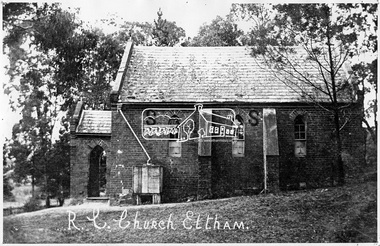
Negative - Photograph, Tom Prior, St Mary's Roman Catholic Church, Eltham, c.1900
... South, opposite the present-day Wingrove Park. It was blessed... South, opposite the present-day Wingrove Park. It was blessed ...The original St Mary’s Roman Catholic Church (1865-1912) was built of clay brick with buttress walls and a slate roof on the corner of Fordhams Road and Maria Street (Main Road), Eltham South, opposite the present-day Wingrove Park. It was blessed on September 3, 1865. With the arrival of the railway in 1901 and the town centre moving closer to the station, the decision was made to relocate the site of the church to its present-day location on Henry Street at the corner of Main Road. A new timber weatherboard church, also called St Mary's was erected and blessed on October 13, 1912. The church and land cost £1,400 (Evelyn Observer). The original brick church It was demolished in the 1920s and the bricks and windows were recycled to build a dairy on the Brinkkotter farm at Research. The timber church was destroyed by fire in 1961 and a new modern architectural (1960s) style church was erected in its place and named Our Lady of Help Christians Church.This photo forms part of a collection of photographs gathered by the Shire of Eltham for their centenary project book,"Pioneers and Painters: 100 years of the Shire of Eltham" by Alan Marshall (1971). The collection of over 500 images is held in partnership between Eltham District Historical Society and Yarra Plenty Regional Library (Eltham Library) and is now formally known as the 'The Shire of Eltham Pioneers Photograph Collection.' It is significant in being the first community sourced collection representing the places and people of the Shire's first one hundred years. The Reynolds family were early settlers in Research. The Reynolds/ Prior collection of photographs were taken by Tom Prior, the maternal uncle of Ivy Reynolds, around 1900 and the 60 photos in the album give a fine overview of many of the landmarks of Research and Eltham over 100 years ago. lvy lived in the family home for many years at 106 Thompson Cres Research. Ivy's father, Ernst Richard Reynolds and grandfather, Richard Reynolds, lived at the same address. Ivy's father Richard worked for Mr. Trail on his property in Research. Reynolds Road is named after the family. Mr Tom Prior (wife Eva) worked at the Melbourne zoo. He was very innovative and made his own camera, using the black cloth hood to exclude the light. The photographs are a reminder of the rural nature of Research and Eltham and its rich heritage.Digital image 4 x 5 inch B&W Negsepp, shire of eltham pioneers photograph collection, eltham, roman catholic church, brinkkotter, catholic church, church, reynolds prior collection, st marys catholic church -
 Eltham District Historical Society Inc
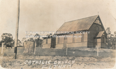
Postcard - Photograph, St Mary's Catholic Church, cnr Main Road and Henry Street, Eltham, c.1912
... South, opposite the present-day Wingrove Park. It was blessed... South, opposite the present-day Wingrove Park. It was blessed ...The original St Mary’s Roman Catholic Church (1865-1912) was built of clay brick with buttress walls and a slate roof on the corner of Fordhams Road and Maria Street (Main Road), Eltham South, opposite the present-day Wingrove Park. It was blessed on September 3, 1865. With the arrival of the railway in 1901 and the town centre moving closer to the station, the decision was made to relocate the site of the church to its present-day location on Henry Street at the corner of Main Road. A new timber weatherboard church, also called St Mary's was erected and blessed on October 13, 1912. The church and land cost £1,400 (Evelyn Observer). The original brick church It was demolished in the 1920s and the bricks and windows were recycled to build a dairy on the Brinkkotter farm at Research. The timber church was destroyed by fire in 1961 and a new modern architectural (1960s) style church was erected in its place and named Our Lady of Help Christians Church.PostcardReturn to Garnet Burges, Judge Bookchurches, catholic churches, st marys, main road, henry street, eltham -
 Eltham District Historical Society Inc
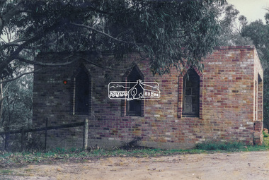
Photograph, Old dairy on the Brinkkotter farm, Research, Vic, Jul. 2001
... South, opposite the present-day Wingrove Park. It was blessed... South, opposite the present-day Wingrove Park. It was blessed ...The original St Mary’s Roman Catholic Church (1865-1912) was built of clay brick with buttress walls and a slate roof on the corner of Fordhams Road and Maria Street (Main Road), Eltham South, opposite the present-day Wingrove Park. It was blessed on September 3, 1865. With the arrival of the railway in 1901 and the town centre moving closer to the station, the decision was made to relocate the site of the church to its present-day location on Henry Street at the corner of Main Road. A new timber weatherboard church, also called St Mary's was erected and blessed on October 13, 1912. The church and land cost £1,400 (Evelyn Observer). The original brick church was demolished in the 1920s and the bricks and windows were recycled to build a dairy on the Brinkkotter farm at Research. The timber church was destroyed by fire in 1961 and a new modern architectural (1960s) style church was erected in its place and named Our Lady of Help Christians Church.Colour photographresearch (vic.), brinkkotter, catholic church, eltham, roman catholic church, st marys catholic church -
 Warrnambool and District Historical Society Inc.
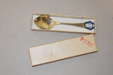
Souvenir Spoon, Pitcher Company, Warrnambool Bowling Club, 1970s
... in 1868 but the present day Warrnambool Bowls Club was founded... but the present day Warrnambool Bowls Club was founded in 1890 ...This is a souvenir jam spoon which would have been given or sold to Warrnambool Bowling Club members and visitors to Warrnambool. The game of lawn bowls was first played in Warrnambool in 1868 but the present day Warrnambool Bowls Club was founded in 1890, with a bowling green in Liebig Street, Warrnambool. Today the club has its facilities in Kelp Street Warrnambool and its logo features a Warrnambool lighthouse.This spoon is a memento of the Warrnambool Bowls Club and shows the type of souvenir popular with members and tourists some 40 or 50 years ago. This is an electro-plated nickel silver jam spoon. It has a coloured metal piece welded into the top of the spoon. This has been enamelled in blue, white and silver and has an image of a lighthouse and some printing. There are also some markings on the back of the spoon. The spoon is in a cream-coloured cardboard box which is rectangular-shaped. Spoon: Warrnambool Bowling Club Pitcher EPNS A1 Box: Pitcher Fine Silverware warrnambool bowls club, history of warrnambool -
 Eltham District Historical Society Inc
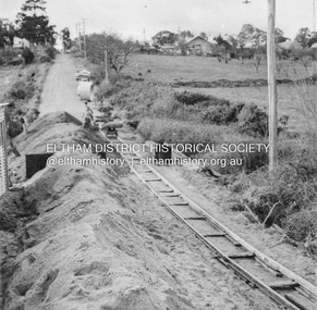
Album - Photograph, J.A. McDonald, Eltham-Greensborough Road, July 1956
... and improvements to the intersection. On the immediate right is the present... in place as of present day (2022). In many situations, the photos ...Diamond Creek Bridge (Bridge Street Bridge) General view looking to Main Road View looking east up Bridge Street to Main Road prior to widening. The Eltham Obelisk is located at the top of the hill on the left but was relocated to the Eltham RSL front garden as a reesult of road widening works and improvements to the intersection. On the immediate right is the present-day Eltham Rugby Union ovalRecord of various Shire of Eltham infrastructure works undertaken during the period of 1952-1962 involving bridge and road reconstruction projects, sometimes with Eltham Shire Council Project Reference numbers quoted. It was during this period that a number of significant improvements were made to roads and new bridges constructed within the shire that remain in place as of present day (2022). In many situations, the photos provide a tangible visible record of infrastructure that existed throughout the early days of the Shire. The album was put together by or under the direction of the Shire Engineer, J.A. McDonald.infrastructure, road construction, shire of eltham, bridge construction, bridge street bridge, eltham, eltham-greensborough road, 1956-07 -
 Eltham District Historical Society Inc
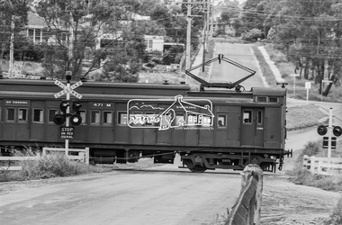
Photograph, Single Motor Carriage 471M Tait (Red Rattler) train passing through the level crossing at Wattletree Road, Eltham, c.1970, 1970
... (present day Local History Centre and home to Eltham District... (present day Local History Centre and home to Eltham District ...Note the blue stone edging surrounding the grassy island in the intersection. This stone was originally part of the blue stone lock-up situated behind the Police Station and residence at 728 Main Road (present day Local History Centre and home to Eltham District Historical Society). Following a redesign of the intersection the stone was again relocated back to 728-730 Main Road for use as garden edging.Digital TIFF file Scan of 35mm Ilford HP4 black and white transparency471m, 728 main road, local history centre, lockup, police station, red rattler, single motor carriage, tait train, wattletree road -
 Eltham District Historical Society Inc
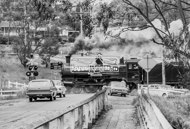
Photograph, Steam locomotive D639 with Tait (Red Rattler) carriages passing through the level crossing at Wattletree Road, Eltham bound for Hurstbridge, c.1970, 1970
... (present day Local History Centre and home to Eltham District... (present day Local History Centre and home to Eltham District ...Note the blue stone edging surrounding the grassy island in the intersection. This stone was originally part of the blue stone lock-up situated behind the Police Station and residence at 728 Main Road (present day Local History Centre and home to Eltham District Historical Society). Following a redesign of the intersection the stone was again relocated back to 728-730 Main Road for use as garden edging.Digital TIFF file Scan of 35mm Ilford HP4 black and white transparency728 main road, d-639, eltham, level crossing, local history centre, lockup, main road, police station, railway parade, red rattler, steam engine, wattletree road, wattletree road bridge -
 Greensborough Historical Society
Folder (article and photographs), Greensborough Pool in the Plenty River / compiled by Marilyn Smith, 1937o
... bridge and present day photographs are also included. A short... from the Main Street bridge and present day photographs ...Society member Marilyn Smith has compiled a collection of historic articles from local newspapers, historic and modern photographs of the swimming pool in the Plenty River Greensborough, opened in 1937. The Pool is still visible from the Main Street bridge and present day photographs are also included. A short story by Gary Partington tells of his memories of the Plenty River as he was growing up.An historical view of the Greensborough pool in the Plenty River.Folder with pink plastic cover. 12 pages of text and photographs.plenty river, greensborough swimming pool, marilyn smith, gary partington -
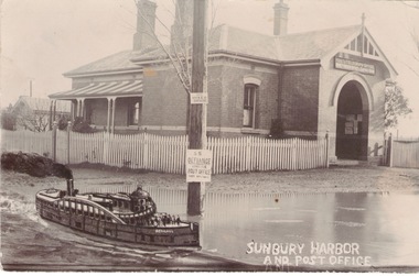 Sunbury Family History and Heritage Society Inc.
Photograph, Sunbury Post Office
... Railway Station. Although the present day post office is still... Station. Although the present day post office is still ...The Sunbury Post Office with a residence pictured in the image was the first official post office building in the town. It opened on the corner of Brook and Evans Streets in 1892. Prior to that time postal services were conducted in an office at Sunbury Railway Station. Although the present day post office is still on the Brook-Evans Streets corner, the building has undergone many changes in services and appearances over the years. Like many country towns, the post office offered many services to the residents over the years. short message has been written on the back to a person in Stirling WA.sunbury post office, sunbury railway station, brook street, evans street, post offices -
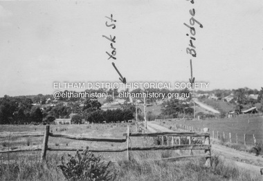 Eltham District Historical Society Inc
Album - Photograph, J.A. McDonald, Eltham-Diamond Creek Road, 21 Oct. 1953
... . On the far side of Brisbane Street is the site of present-day.... On the far side of Brisbane Street is the site of present-day ...Diamond Street Bridge 21st October, 1953 (showing York St., Bridge St., and Brisbane St in immediate foreground) View from intersection of Silver Street at Brisbane Street looking east. On the far side of Brisbane Street is the site of present-day Bunnings store. At the visible end of Brisbane Street where it turns right it then became Susan Street but today continues to the intersection with Bridge Street.Record of various Shire of Eltham infrastructure works undertaken during the period of 1952-1962 involving bridge and road reconstruction projects, sometimes with Eltham Shire Council Project Reference numbers quoted. It was during this period that a number of significant improvements were made to roads and new bridges constructed within the shire that remain in place as of present day (2022). In many situations, the photos provide a tangible visible record of infrastructure that existed throughout the early days of the Shire. The album was put together by or under the direction of the Shire Engineer, J.A. McDonald.infrastructure, road construction, shire of eltham, 1953-10-21, bridge construction, brisbane street, silver street, susan street, york street -
 Federation University Historical Collection
Document - Document - Letter, Ballarat Junior Technical School: Report from The Overseas Telecommunications Commission (Australia), 1958
... from the time he joined the Commission, 9-1-1956 to the present... the time he joined the Commission, 9-1-1956 to the present day. He ...The Overseas Telecommunications Commission (Australia) sent a progress report of Edwin Reginald Willingham to Mr Garner of Ballarat Junior Technical School. It outlines the training history from the time he joined the Commission, 9-1-1956 to the present day. He is to commence six months probation as Acting Telegraphist on 19-5-1958. He came straight from BJTS and has made steady progress. Cream page, typed. Letterhead written in blue ink Signature C W Carthewballarat junior technical school, head master, l garner, overseas telecommunications commission (australia), edwin reginald willingham, dux at ballarat junior technical school, c w carthew, acting telegrphist, training history -
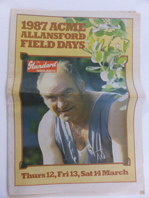 Warrnambool and District Historical Society Inc.
Document, Newspaper The Standard 1987 ACME, March 11 1987
... beginning in 1982 and continuing to the present day. Exhibitors... and continuing to the present day. Exhibitors and companies from all over ...This paper which is a supplement to the Warrnambool Standard presents events and information regarding the Acme Field Days. The Acme Field Days are held each year at Allansford beginning in 1982 and continuing to the present day. Exhibitors and companies from all over the state display their wares at the field days and the three day event usually attracts large numbers of visitors, many of whom come from the agricultural industries. A record of a local event which contains articles and farm practices of the time as well as a comprehensive collection of advertisements from local businesses.Newspaper with coloured photograph on man head and shoulders shot in overalls, with sprig of green across right side of page. Text in brown. Date in brown at bottom of page. Back cover has bright blue border with pink and black text. 32 pages Warrnambool Standard. Acme Field Days Wednesday March 11, 1987warrnambool, warrnambool standard march 1987, acme field days 1987 -
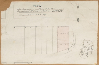 Bacchus Marsh & District Historical Society
Map, Plan showing relative positions of the Gisborne road formation and Mr. Cosgrove's land in Darley. 1907
... to as 'Cosgroves' in this plan is located close to the present day Darley... to as 'Cosgroves' in this plan is located close to the present day Darley ...No background information about the roadworks referred to in this plan has been found. The portion of land referred to as 'Cosgroves' in this plan is located close to the present day Darley Park Recreation Park in Darley, near Bacchus Marsh. The land indicated appears to be close to the corner of Grey Street and Gisborne Road. James Cosgrove who died in 1923 aged 65 owned a farm of 52 acres in this area of Darley.Single page map showing a proposed deviation of the Gisborne road in Darley and its position relative to land owned by Mr. Cosgrove. The land owned by Cosgrove is shaded in pink. No scale indicated. Part of a set of maps which are pasted into a bound volume containing 76 maps or plans in total. High resolution digital image stored on BMDHS computer network. Signature (illegible), Eng, Bac Marsh Shire, 30/9/07bacchus marsh roads and streets, darley victoria maps -
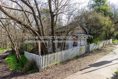 Eltham District Historical Society Inc
Photograph, Peter Pidgeon, Former Bootmaker's shop and White Cloud Cottage, 701 Main Road, Eltham, 2 Aug. 2022
... reserve west of Main Road (now present-day Wingrove Park Trail... road reserve west of Main Road (now present-day Wingrove Park ...Situated originally on the corner of the Dalton Street road reserve west of Main Road (now present-day Wingrove Park Trail), the former Jarrold Cottage (White Cloud) was purchased by Lena Skipper following Thekla Jarrold's death in 1943. It was built by William Jarrold in the early 1850s and was here that he married Hannah Coleman in 1856. The Bootmaker's shop was built by Thekla Jarrold in 1930 for use by her friend, John Clark, a local photographer who had boarded with the Jarrold family since about 1910. In 1930 he changed profession to a bootmaker and leather worker. The shop is one of only three remaining early 20th century shops in what was Little Eltham, the others being present-day San Antionio Barber Shop at 820 Main Road and Cafe Zen Den at 736 Main Road. Part of a presentation by Peter Pidgeon to the Society, 13 August 2022 showcasing a series of photographs taken by John Henry Clark over the period 1895 to 1930.Born Digitaleltham, main road, bootmaker's shop, jarrold cottage, white cloud cottage, shops, wingrove park trail -
 Eltham District Historical Society Inc
Photograph, Peter Pidgeon, Former Bootmaker's shop, 701 Main Road, Eltham, 2 Aug. 2022
... reserve west of Main Road (now present-day Wingrove Park Trail... road reserve west of Main Road (now present-day Wingrove Park ...Situated originally on the corner of the Dalton Street road reserve west of Main Road (now present-day Wingrove Park Trail), the former Jarrold Cottage (White Cloud) was purchased by Lena Skipper following Thekla Jarrold's death in 1943. It was built by William Jarrold in the early 1850s and was here that he married Hannah Coleman in 1856. The Bootmaker's shop was built by Thekla Jarrold in 1930 for use by her friend, John Clark, a local photographer who had boarded with the Jarrold family since about 1910. In 1930 he changed profession to a bootmaker and leather worker. The shop is one of only three remaining early 20th century shops in what was Little Eltham, the others being present-day San Antionio Barber Shop at 820 Main Road and Cafe Zen Den at 736 Main Road. Part of a presentation by Peter Pidgeon to the Society, 13 August 2022 showcasing a series of photographs taken by John Henry Clark over the period 1895 to 1930.Born Digitaleltham, main road, bootmaker's shop, jarrold cottage, white cloud cottage, shops, wingrove park trail -
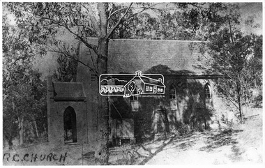 Eltham District Historical Society Inc
Negative - Photograph, Eltham - Old R.C. Church (building not there in 1923)
... the present-day Wingrove Park. It was blessed on September 3, 1865... the present-day Wingrove Park. It was blessed on September 3, 1865 ...Eltham - Old R.C. Church (building not there in 1923). The original St Mary’s Roman Catholic Church (1865-1912) was built of clay brick with buttress walls and a slate roof on the corner of Fordhams Road and Maria Street (Main Road), Eltham South, opposite the present-day Wingrove Park. It was blessed on September 3, 1865. With the arrival of the railway in 1901 and the town centre moving closer to the station, the decision was made to relocate the site of the church to its present-day location on Henry Street at the corner of Main Road. A new timber weatherboard church, also called St Mary's was erected and blessed on October 13, 1912. The church and land cost £1,400 (Evelyn Observer). The original brick church It was demolished in the 1920s and the bricks and windows were recycled to build a dairy on the Brinkkotter farm at Research. The timber church was destroyed by fire in 1961 and a new modern architectural (1960s) style church was erected in its place and named Our Lady of Help Christians Church.This photo forms part of a collection of photographs gathered by the Shire of Eltham for their centenary project book,"Pioneers and Painters: 100 years of the Shire of Eltham" by Alan Marshall (1971). The collection of over 500 images is held in partnership between Eltham District Historical Society and Yarra Plenty Regional Library (Eltham Library) and is now formally known as the 'The Shire of Eltham Pioneers Photograph Collection.' It is significant in being the first community sourced collection representing the places and people of the Shire's first one hundred years.Digital image 4 x 5 inch B&W Negsepp, shire of eltham pioneers photograph collection, eltham, roman catholic church, catholic church, church, main road, st marys catholic church -
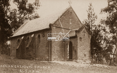 Eltham District Historical Society Inc
Negative - Photograph, St Mary's Roman Catholic Church, Eltham, c.1910
... and Maria Street (Main Road), Eltham South, opposite the present-day... and Maria Street (Main Road), Eltham South, opposite the present-day ...Note the extensive cracking of the mortar and bricks in the front facade near the portico entrance. The original St Mary’s Roman Catholic Church (1865-1912) was built of clay brick with buttress walls and a slate roof on the corner of Fordhams Road and Maria Street (Main Road), Eltham South, opposite the present-day Wingrove Park. It was blessed on September 3, 1865. With the arrival of the railway in 1901 and the town centre moving closer to the station, the decision was made to relocate the site of the church to its present-day location on Henry Street at the corner of Main Road. A new timber weatherboard church, also called St Mary's was erected and blessed on October 13, 1912. The church and land cost £1,400 (Evelyn Observer). The original brick church It was demolished in the 1920s and the bricks and windows were recycled to build a dairy on the Brinkkotter farm at Research. The timber church was destroyed by fire in 1961 and a new modern architectural (1960s) style church was erected in its place and named Our Lady of Help Christians Church.This photo forms part of a collection of photographs gathered by the Shire of Eltham for their centenary project book,"Pioneers and Painters: 100 years of the Shire of Eltham" by Alan Marshall (1971). The collection of over 500 images is held in partnership between Eltham District Historical Society and Yarra Plenty Regional Library (Eltham Library) and is now formally known as the 'The Shire of Eltham Pioneers Photograph Collection.' It is significant in being the first community sourced collection representing the places and people of the Shire's first one hundred years.Digital image 4 x 5 inch B&W Neg Sepia postcardsepp, shire of eltham pioneers photograph collection, eltham, roman catholic church, church, catholic church, main road, st marys catholic church -
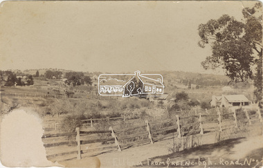 Eltham District Historical Society Inc
Postcard - Photograph, Eltham from Greensborough Road, No. 1, c.1910
... (present-day Sherbourne Road) across Bolton and Bridge streets... (present-day Sherbourne Road) across Bolton and Bridge streets ...The view is looking southeast from near Eltham Road (present-day Sherbourne Road) across Bolton and Bridge streets towards the village of Little Eltham running down the main road (Maria Street) . On the immediate right is Mrs Mary Jane Smart's family home located on the north side of Bridge Street at the intersection with Bolton Street, facing Bolton Street (now part of present day Brisbane Street and occupied by the Kitchen Design Centre). An original early settler's cottage, it was built by Mary Jane Smart's parents, Edwin Bailey and Jane (nee Matthews). Mary Jane Smart was born in the cottage. She married an Englishman, Alexander Wilson Smart who disappeared to Western Australia in the early 1900s in search of gold. He ultimately married again in W.A., committing bigamy and then committed murder and was hung in 1911. Visible at the top left are Watson's (two-storey) Eltham Hotel at the corner of Pitt Street and Maria Street and the Evelyn Hotel directly opposite.Sepia postcardNotations in biro 'A. Petrie', rest in pencil as follows St Margarets N end Shows Wesleyan Church Small Bank Double Storey on Hotel's south end Pearsons house Note roof structure Surface damage to lower left corner1910, bridge street, cba bank, church, clark bros. photo, early settlers, eltham, eltham hotel, evelyn hotel, fountain of friendship hotel, greensborough, mary jane smart (nee bailey), pearson house, pre 1900, road no 1, smart family home, smart home, st margarets, watsons hotel, wesleyan church -
 Eltham District Historical Society Inc
Negative - Photograph, Eltham, Vic, c.1890
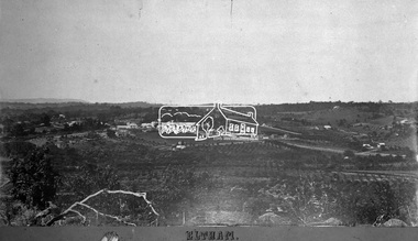
... View looking northeast from present day Ely Street (near... melbourne View looking northeast from present day Ely Street (near ...View looking northeast from present day Ely Street (near intersection of present day Cronus Court and Porter Street) across what will become the site of Eltham High School towards Main Road showing the Eltham Courthouse and Police station. View is very similar to the sketch of Eltham published in 'The Illustrated Australasian News', December 26, 1884, p212. Note the large bluestone cell block behind police house and stable. George Knapman's Shoeing Forge next to the courthouse and the concentration of buildings around the Evelyn Hotel and Watson's Eltham Hotel on opposite sides of Main Road at Pitt street. Also note George Stebbing's cottage (c.1860) on Pitt Street behind the courthouse and 'Sunnyside' (home of W.J. Taylor built c.1885) at the top of the hill on Bible Street. In the foreground are orchards running up to the main street, Maria Street and also between Brougham Street and Dalton Street bordered by Bible Street.This photo forms part of a collection of photographs gathered by the Shire of Eltham for their centenary project book,"Pioneers and Painters: 100 years of the Shire of Eltham" by Alan Marshall (1971). The collection of over 500 images is held in partnership between Eltham District Historical Society and Yarra Plenty Regional Library (Eltham Library) and is now formally known as the 'The Shire of Eltham Pioneers Photograph Collection.' It is significant in being the first community sourced collection representing the places and people of the Shire's first one hundred years.Digital image 4 x 5 inch B&W Negshire of eltham pioneers photograph collection, eltham, 1890, bible street, brougham steet, dalton street, eltham courthouse, eltham hotel, evelyn hotel, franklin street, grant house, knapmans forge, main road, maria street, orchards, police residence, police station, pre 1900, stebbing cottage, sunnyside, w.b. andrew corn store, watsons hotel, little eltham -
 Bendigo Historical Society Inc.
Book - ABORIGINAL PLACE NAMES, 1967
... , Appendix A: word list, Appendix B: present day names. Loose inside... A: word list, Appendix B: present day names. Loose inside ...Aboriginal Place Names. List of Aboriginal place names, Appendix A: word list, Appendix B: present day names. Loose inside the front cover is a newspaper cutting, one one side is a short report on a new National Anthem, and on other are references to Murray Farm Primary School, Carlingford. Below that is a reference to Comenarra Parkway between South Turramurra and Thornleigh. This cutting is dated 12/02/74. Also inside front cover is pasted a cutting relatingto a place name titled 'Who'd Live At Stinking Tree'. This cutting was submitted to the Daily Telegraph by author A. W. Reed, Date unknown.A. W. Reedaboriginal, book, place names., place names and meanings. -
 Warrnambool and District Historical Society Inc.
Program, Into the woods, 1997
... , with the present day Warrnambool Theatre Company evolving from... throughout its history, with the present day Warrnambool Theatre ...This is a programme for the 1997 Warrnambool Theatre Company production of ‘Into the Woods’. Warrnambool has had many drama and theatrical groups throughout its history, with the present day Warrnambool Theatre Company evolving from the Warrnambool Theatre Group which was founded in 1948. Plays and musicals have been produced each year since, with most productions being staged at the Warrnambool Town Hall/Performing Arts Centre/Lighthouse Theatre. This programme is of interest as an example of the productions staged by the Warrnambool Theatre Company. This is a booklet of 16 pages with a white cover. On the front cover is an illustration of a wooded forest in black and white tonings with the lettering in black and white. The back cover has an advertisement in black and white. The booklet contains advertisements, information on the play and the theatrical performers and producers and black and white photographs. The booklet is bound with metal staples. warrnambool theatre company, history of warrnambool -
 Warrnambool and District Historical Society Inc.
Stamp, W'bool Co.op Commons Seal, 1945
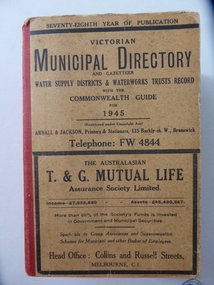
... shires to form the present day Shire of Moyne. ... shires to form the present day Shire of Moyne. This book is very ...This is a Victorian Municipal Directory for 1945, containing general information on all municipalities in Victoria, a Gazeteer, a Commonwealth Guide and a Water Supply Record. Municipal Directories were published annually in Victoria from 1867 on. This directory came from the Shire of Mortlake which was established in 1864 when it had an area of 2137 square kilometres. The Shire of Mortlake was abolished in 1994 and merged with other neighbouring shires to form the present day Shire of Moyne. This book is very useful to researchers as it contains much information on the City, Borough and Shire structures, the Council employees and Government employees of all the municipalities. It has, therefore, important local information on Warrnambool and the surrounding areas in 1945. This is a soft cover book of 1114 pages. It has a buff- coloured cover with red binding on the spine. The printed material on the covers is printed in black. It has a blue stamp of the Shire of Mortlake on several pages. The book contains several advertisements for Melbourne businesses. ‘Shire of Mortlake’ shire of mortlake, local government in victoria, warrnambool history -
 Warrnambool and District Historical Society Inc.
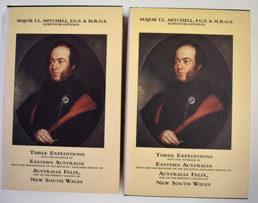
book - Books, Eagle Press, Mitchell's Three Expeditions into Eastern Australia, 1996
... of present day Victoria which he named Australia Felix... of present day Victoria which he named Australia Felix ...Major Thomas Mitchell historical writing.This is set number 223 of two facsimile volumes of an historical work. The covers are green with gold printing and the dust covers are cream with black printing and two colour illustrations. The pages contain printed text and illustrations, both black and white and coloured. There are two inserts, one a map and the other showing a New South Wales natural feature. The two volumes are contained in a hardcover green folder.non-fictionMajor Thomas Mitchell historical writing.major mitchell, australia felix squatting period -
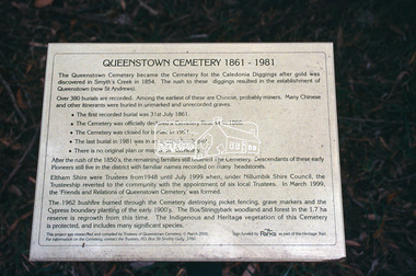
 Eltham District Historical Society Inc
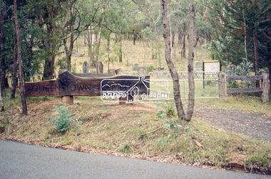
Slide - Photograph, Queenstown Cemetery, Smiths Gully Road, St Andrews, c.2004
... to the establishment of Queenstown (present day St Andrews). The first recorded... to the establishment of Queenstown (present day St Andrews). The first recorded ...The discovery of gold in Smyth's Creek in 1854 and subsequent gold rush to the Caledonia diggings led to the establishment of Queenstown (present day St Andrews). The first recorded burial was July 31st, 1861 and it was officially declared a Cemetery Reserve in 1866. Many graves are unmarked and unrecorded including many Chinese and other itinerant miners. The cemetery was closed for new burials in 1851. The last recorded burial was in 1981 in an existing family grave.35mm colour positive transparency Mount - white 7 dots (Technodia Italy)queenstown cemetery, smiths gully road, st andrews -
 Eltham District Historical Society Inc
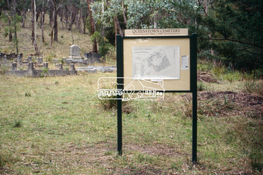
Slide - Photograph, Queenstown Cemetery, Smiths Gully Road, St Andrews, c.2004
... to the establishment of Queenstown (present day St Andrews). The first recorded... to the establishment of Queenstown (present day St Andrews). The first recorded ...The discovery of gold in Smyth's Creek in 1854 and subsequent gold rush to the Caledonia diggings led to the establishment of Queenstown (present day St Andrews). The first recorded burial was July 31st, 1861 and it was officially declared a Cemetery Reserve in 1866. Many graves are unmarked and unrecorded including many Chinese and other itinerant miners. The cemetery was closed for new burials in 1851. The last recorded burial was in 1981 in an existing family grave.35mm colour positive transparency Mount - white 7 dots (Technodia Italy)queenstown cemetery, smiths gully road, st andrews -
 Eltham District Historical Society Inc
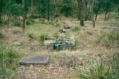
Slide - Photograph, Queenstown Cemetery, Smiths Gully Road, St Andrews, c.2004
... to the establishment of Queenstown (present day St Andrews). The first recorded... to the establishment of Queenstown (present day St Andrews). The first recorded ...The discovery of gold in Smyth's Creek in 1854 and subsequent gold rush to the Caledonia diggings led to the establishment of Queenstown (present day St Andrews). The first recorded burial was July 31st, 1861 and it was officially declared a Cemetery Reserve in 1866. Many graves are unmarked and unrecorded including many Chinese and other itinerant miners. The cemetery was closed for new burials in 1851. The last recorded burial was in 1981 in an existing family grave.35mm colour positive transparency Mount - white 7 dots (Technodia Italy)queenstown cemetery, smiths gully road, st andrews -
 Eltham District Historical Society Inc
Slide - Photograph, Queenstown Cemetery, Smiths Gully Road, St Andrews, c.2004
... to the establishment of Queenstown (present day St Andrews). The first recorded... to the establishment of Queenstown (present day St Andrews). The first recorded ...The discovery of gold in Smyth's Creek in 1854 and subsequent gold rush to the Caledonia diggings led to the establishment of Queenstown (present day St Andrews). The first recorded burial was July 31st, 1861 and it was officially declared a Cemetery Reserve in 1866. Many graves are unmarked and unrecorded including many Chinese and other itinerant miners. The cemetery was closed for new burials in 1851. The last recorded burial was in 1981 in an existing family grave.35mm colour positive transparency Mount - white 7 dots (Technodia Italy)queenstown cemetery, smiths gully road, st andrews -
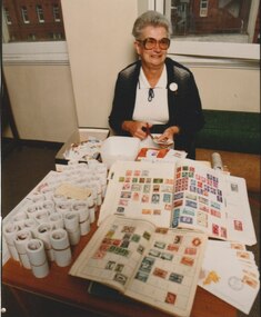 Melbourne Legacy
Photograph - Photo, Stamp sorting, Widows activities, 1988
... stamps and sold to a stamp dealer for many years to the present... and sold to a stamp dealer for many years to the present day ...A Legacy widow, Beryl Billing, with stamp albums and loose stamps. Beryl Billing was the co-ordinator of the stamp sorting for many years and wrote progress reports in the Answer in the 1990s. Photo reference 881117 on the back is assumed to mean the date was 17 November 1988 The widows clubs have sorted used stamps and sold to a stamp dealer for many years to the present day. It raises some funds and provides a purpose for gathering together. A record of the type of activities Legacy provided as a social outlet for widows and for fundraising. Colour photo x 3 of Beryl Billing with stamps.Label on the back from Keesing Photographic.widows, fundraising, stamps, beryl billing -
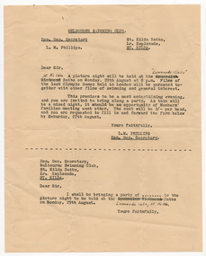 St Kilda Historical Society
Ephemera - Invitation, Melbourne Swimming Club, c1949
... in 1894 and is not the same as the present day competitive... and is not the same as the present day competitive swimming club of that name ...Invitation in the form of a typed letter from the General Secretary of the Melbourne Swimming Club,, L M (Les) Phillips to attend a picture night at Leonards Cafe Baths on Monday 29 August. The films shown included films of the 1948 London Olympics and other films of swimming and general interest. The year of the event is unspecified. It could have been 1949 or 1955. The Club was established in 1894 and is not the same as the present day competitive swimming club of that name. Quarto sized page of buff coloured paper, typed and written in black on one sideHandwritten correction of typed venue of event, changed from Gymnasium Richmond to "Leonards Cafe" St Kildamelbourne swimming club -
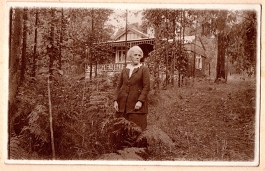 Southern Sherbrooke Historical Society Inc.
Photograph
... . The house is probably located at present-day 20 Monbulk Road... is probably located at present-day 20 Monbulk Road, Belgrave ...Photo of a woman of about sixty standing in a garden with a house in the background. The woman has thick grey/white hair swept back, and she is unsmiling and looking to her left. She is wearing a dark skirt and jacket with three buttons over a pale blouse with a frilled collar. In her hands is a twig or piece of grass or similar. There is a wedding ring on her hand. The house in the background is the same house as in other photos. The land slopes upwards and Monbulk Road is most likely hidden by the thick bush behind the house. Trees and bracken edge a cleared area of land. The house is probably located at present-day 20 Monbulk Road, Belgrave and is no longer standing.