Showing 3331 items
matching router
-
 Melbourne Tram Museum
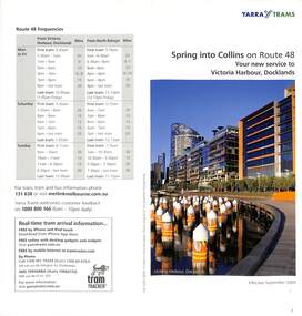
Pamphlet, Yarra Trams, "Spring into Collins on Route 48 - Your new service to Victoria Harbour, Docklands", Sep. 2009
Pamphlet - 2 fold DL - titled "Spring into Collins on Route 48 - Your new service to Victoria Harbour, Docklands", September 2009, includes changes to Collins St services, route 70, map, with a listing of service frequencies.trams, tramways, collins st, victoria harbour, route 48, new tramway, docklands -
 Melbourne Tram Museum
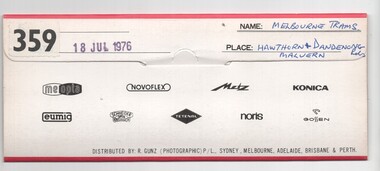
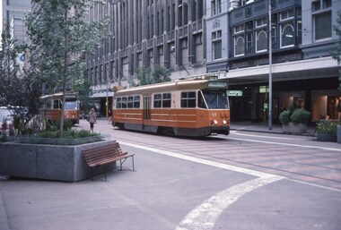
Negative, Bruce Herbert, "Melbourne Trams - Hawthorn and Dandenong Road", 18/07/1976 12:00:00 AM
Negative folder - made by SAGA Japan, containing 11 no. 120 film negatives 60mm x 60mm of Melbourne Trams at the intersection of Hawthorn and Dandenong Road 18 Jul 1976, stamped "359". .1 - Harris train at Malvern station area. .2 - Neerim Road Caulfield level crossing .3 - Caulfield - Glenhuntly sidings .4 - 899, route 69, Kew Cotham Road, with an Army advert. .5 - ditto, out of focused. .6 - 905 route 64 .7 - 1021 - route 64 - has a Kodak advert. .8 - 805, Dandenong Road, route 64 .9 - 904 route 64 .10 - W2 331? running a special Three megs not scanned.trams, tramways, sw6 class, dandenong rd, hawthorn rd, route 64, route 69, w2 class, railways, tram 899, tram 905, tram 1021, tram 904, w7 class, w5 class, mmtb -
 Port Melbourne Historical & Preservation Society
Photograph - Bridge Street tram crossing, Port Melbourne, Jack Bolt, 2011
Colour photographs of Bridge Street tram crossing and of tram approaching. 109 tram routetransport - tramways -
 Whitehorse Historical Society Inc.
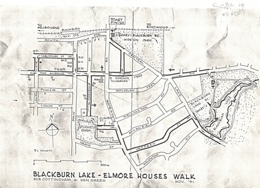
Map, Blackburn Lake - Elmore houses walk, 1/11/1991
Map of Blackburn outlining a walk through the lake.Map of Blackburn outlining a walk through the lake. The route includes four Elmore houses.Map of Blackburn outlining a walk through the lake.maps, blackburn lake sanctuary, the avenue, blackburn, laburnum street, main street, gardenia street, blackburn road, gordon crescent -
Whitehorse Historical Society Inc.
Book, The Herald Road Guide, 1930's
A Road Guide Book of Victoria and routes to Sydney, Brisbane, Canberra, Adelaide and Alice Springs.A Road Guide Book of Victoria and routes to Sydney, Brisbane, Canberra, Adelaide and Alice Springs.A Road Guide Book of Victoria and routes to Sydney, Brisbane, Canberra, Adelaide and Alice Springs.maps, tourism, australia, victoria -
 Ballarat Tramway Museum
Photograph - Digital image, Chris Phillips, c1970
Yields information about the Drummond St south and tram operations.Digital image of No. 42 southbound in Drummond St South en route to Sebastopol, c1970trams, tramways, drummond st sth, sebastopol, tram 43 -
 Whitehorse Historical Society Inc.
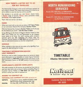
Pamphlet - Bus Timetable, National Bus Company Pty LTD, North Nunawading Bus Services, 10/10/1994
A National Bus Line map and timetable for North Nunawading in 1994 (Routes 270 and 271)A National Bus Line map and timetable for North Nunawading in 1994 (Routes 270 and 271)non-fictionA National Bus Line map and timetable for North Nunawading in 1994 (Routes 270 and 271) -
 Melbourne Tram Museum
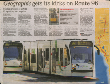
Newspaper, The Age, "Geographic gets its kicks on Route 96", Jan. 2010
Newspaper clipping from The Age, late Jan 2010, titled "Geographic gets its kicks on Route 96" following the publication of the January 2010 issue of National Geographic featuring Route 96. Includes a map of the route, photo of trams 5012 and 5001. Gives a background history, operation, quotes Daniel Bowen of the PTUA. Has a list of the top 10 tram rides identified by the magazine.trams, tramways, route 96, tramways, melbourne, tram 5001, tram 5012 -
 Ballarat Tramway Museum
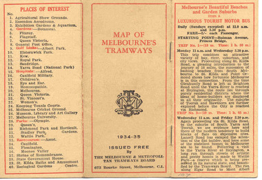
Map, Melbourne and Metropolitan Tramways Board (MMTB), "MMTB Map of Melbourne Tramways 1934-5", 1934
Demonstrates methods of giving information to visitors to Melbourne and yields information about tram services at the time in Melbourne.Very small pocket sized timetable and map book, consisting of 2 octavo cards stapled and folded into 12 pages consisting of three pages of bus and tram round trips, 3 center pages for map of electric and cable trams, route numbers and interest points. Map printed in 4 colours. 4 pages index to routes and first and last trams to City and from City. Also gives points where suburban routes are intersected by City routes. One page devoted to places of interest. All printing in black with red headings and highlights.trams, tramways, mmtb map, mmtb, timetables, tourist trips, map -
 Melbourne Tram Museum
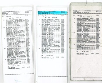
Administrative Record - Table Cards, Yarra Trams, "City Circle Tram Melbourne", 2001 to 2003
Set of printed table cards on paper and laminated. Gives sign on times, car out, trip details and which "run" takes the tram from the crew. .1 - Camberwell Table 23, last update 5/5/03, route 75 .2 - Camberwell Table V043, last update 19/03/03 - has a highlighter on the top of the sheet, route 75. .3 - Camberwell Table V033 - last update 06/08/01 - route 70 .4 - Camberwell Table 39 - effective 30/12/2007 - route 75.trams, tramways, table cards, camberwell depot, drivers, route 70, route 75 -
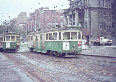 Melbourne Tram Museum
Slide - Set of 2, Keith Caldwell, 30/04/1964 12:00:00 AM
.1 - Agfa colour slide, blue / white plastic mount, photo by Keith Caldwell of W5 767 (Route 11, City Spencer St) and 821 (Kew Depot, route 47). Has the shelter at this stop in the photo. In the photo are tram adverts for Drambuie, Olympic Tyres. .2 - W2 268 running a route 12, to the City Brunswick St with W2 446 in the background, running Mont Albert route 42. Tram 468 has a Remy Martin brandy advert. The St Vincent's Hospital complex is in the background in both photos. 30/4/1964In ink "W2 PM 30-4-64"trams, tramways, route 11, route 47, route 12, route 42, mont albert, city brunswick st, w5 class, w2 class, victoria parade, gisborne st, st vincent's plaza, shelters, kew depot, tram 821, tram 767, tram 268, tram 446 -
 Melbourne Tram Museum
Postcard, Traveller's Notes, Flinders St Station main entrance, Z81 (Route 67), and W6 981 (Route 1), 1995
Postcard - 3 panel full colour - by Traveller's Notes, of Flinders St Station main entrance, Z81 (Route 67), and W6 981 (Route 1). Divided back, published by Traveller's Notes, photos by Neil J Leed, 1995.trams, tramways, flinders st station, z class, w6 class, route 1, route 67, tram 81, tram 981 -
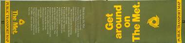 Melbourne Tram Museum
Map, The Met, Public Transport Map - Get around on The Met, c1987
Undated map - c1987 - Neighbourhood and travelcard tickets, has a photo of the front of B2 2004, includes a map of the travelcard neighbourhoods, commuter passes and The Met contact details.Yields information about Melbourne public transport services in c1987Fold out map (36 sections 9 across x 4 deep), "Public Transport Map", coloured of Melbourne's Tram and Bus routes, route numbers, rail lines, detailed for the central part of Melbourne and the outer Metropolitan services.tramways, melbourne, tram services, bus services, railways, maps, travelcard, neighbourhood tickets -
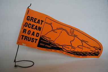 Anglesea and District Historical Society
Pennant, Unknown
Orange pennant flag listing towns on and near the Great Ocean Road. List of town names on pennant - (west to east) Mortlake, Warrnambool, Nirranda, Terang, Port Campbell, Lavers Hill, Colac, Beech Forest, Apollo Bay, Wye, Birregurra, Forrest, Deans Marsh, Peterborough, Princetown, Lorne, Eastern View, Airy's Inlet, Anglesea, Torquay, Geelong, Barwon Heads.GREAT/ OCEAN/ ROAD/ TRUST. Map of Area/ Route of the Great Ocean. (Orange - on wire stand. Printed on both sides.) great ocean road trust -
 Melbourne Tram Museum
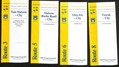
Ephemera - Timetable - The Met - set of 16, The Met, 1993
SSet of 16 The Met timetables, diagrammatic map, major stops and contact details. All dated May 1993 unless noted otherwise. 1 - Route 3 - East Malvern - City with a note that route 377 bus service replaces trams on Sunday. 2 - Route 5 - Malvern (Burke Rd) - City 3 - Route 6 - Glen Iris - City 4 - Route 8 - Toorak - City 5 - Route 10 - Sth Melbourne Beach and St Kilda Beach - West Preston 6 - Route 19 - North Coburg - City with a note that route 319 bus service to Gowrie and Upfield was included - ran Saturday afternoons and Sundays only. 7 - Route 42 - Mont Albert - City 8 - Route 48 - North Balwyn - City 9 - Route 55 - West Coburg - Domain Road interchange - with a note that route 68 operates via Elizabeth St on Sunday. 10 - Route 57- West Maribyrnong - City - with a note that route 357 bus services replaces trams on Sunday 11 - Route 59 - Airport West - City 12 - Route 64 - East Brighton - City 13 - Route 69 - Kew (Cotham Rd) - St Kilda Beach via Glenferrie Road 14 - Route 70 - Wattle Park - Princes Bridge 15 - Route 72 - Camberwell - City 16 - Route 82 - Moonee Ponds - Footscray and that route 223 bus replaces trams on Saturday afternoons and all day Sunday,Yields information about some of The Met tram services May 1993Set of 16 The Met timetables, DL size, printed in two colours.timetables, the met, route 8, route 3, route 5, route 6, route 10, route 19, route 42, route 48, route 55, route 57, route 59, route 64, route 69, route 70, route 72, route 82 -
 Melbourne Tram Museum
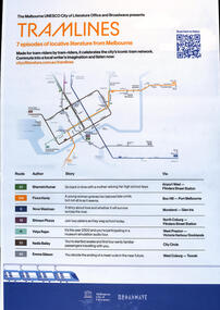
Poster - 7 episodes of tram stories, City of Melbourne, "Tramlines", 2023
Poster published as part of promotion of "7 episodes of locative literature from Melbourne" featuring various stories of Melbourne tram routes from the riders perspective; Shamini Kumar route 59 Fiona Hardy route 109 Nova Weetman route 6 Shivaun Piozza - route 19 Vidya Rajan route 11 Nadia Bailey route 35 Emma Gibson route 58 Includes a map of the central city tram lines. Sponsored by the City of Melbourne and Broadwave. Oct. 2023Demonstrates a series of stories evolving around Melbourne tram routes and life.Poster - A2 printed in full colour.tramways, stories, melbourne, podcasts, tram routes -
 Melbourne Tram Museum
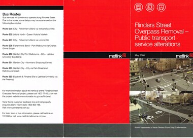
Pamphlet, Metlink, "Flinders Street Overpass Removal - Public transport service alterations", May. 2005
.1 - Pamphlet - DL three fold, full colour on gloss paper, titled "Flinders Street Overpass Removal - Public transport service alterations", giving details of the service alterations to trams and buses using Flinders St during the May 2005 to end of 2005 removal of the overpass. Has a map and images of the intersection of Flinders and King St - with very few cars! .2 - Timetable temporary change sheet for route 48 showing the change of the route to Market St and estimated frequency. Terminus at the time was "New Quay Docklands" .3 - ditto for the extension of Routes 24 to New Quay for the above works. .4 - ditto for route 24 and 30 during the above works. Published by Metlink. Route 48 timetrams, tramways, metlink, flinders st, kingsway, trackwork, route 48, timetables, route 24, route 30, new quay docklands -
 Melbourne Tram Museum
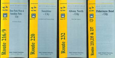
Ephemera - Timetable - bus - The Met - set of 24, The Met, 1992 & 1993
SSet of 24 The Met bus timetables, with diagrammatic map, major stops and contact details. All dated during1993 unless noted otherwise. 1 - Route 216/9 - Deer Park West & Sunshine Park - City 2 - Route 220 - Sunshine - City - 1992 3 - Route 232 - Altona North - City - 1992 4 - Route 233 - Fishermens Bend - City - 1992 5 - Route 254 - Northland Shopping Centre - City - 1992 6 - Route 256 - La Trobe Uni - City - 1992 7 - Routes 258 & 259 - Northland Shopping Centre, and La Trobe Uni - City via Eastern Freeway - 1992 8 - Route 260 etc - Deep Creek Templestow - Donvale - City 9 - Route 264 - Mitcham, Donvale City 10 - Route 265 - Deep Creek - City 11 - Route 602 - Brighton - city 12 - Route 269, 291 and 296 - Greensborough, Heidelberg & Newmans Road to Box Hill 13 - Route 272 - Warrandyte - City 14 - Route 276 & 278 - Warrandyte - City 15 - Route 284 & 270 - East Kew - City or Box Hill 16 - Route 285 - The Pines - Box Hill 17 - Route 286 & 288 - The Pines and Templestowe - Box Hill 18 - Route 290 - North Nunawading - Box Hill 19 - Route 292 etc - Box Hill, Deep Creek, Ringwood, Warrandyte 20 - Route 301, 281 315 - Ringwood, Park Orchards and Donvale - City 21 - Route 305 - Box Hill - Ringwood 22 - Route 366 & 367 - Ringwood - Croydon 23 - Route 600 - St Kilda - Brighton Beach - 1992 24 - Route 601 - Gardenvale - City - 1992Yields information about some of The Met bus services 1993Set of 24 The Met timetables, DL size, printed in two colours.timetables, the met, route 216, route 220, route 232, route 233, route 254, route 258, route 259, route 260, route 264, route 265, route 256, route 602, route 269, route 272, route 276, route 284, route 270, route 285, route 286, route 288, route 290, route 292, route 301, route 305, route 366, route 367, route 600, route 601 -
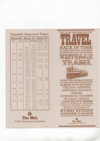 Melbourne Tram Museum
Pamphlet, The Met, "Travel back in Time - Vintage Trams", c1995
Pamphlet - 2 fold DL printed on light card with a fawn colour, titled "Travel back in Time - Vintage Trams", giving details of the Vintage Tram services, mid 1990's using the L class trams. Has map and timetables for route 68 to the Zoo, Route 16 to St Kilda Beach and Route 69 to Kew from the City. Has The Met logo and contact details.trams, tramways, ptc, vintage trams, the met, route 68, route 16, route 69, l class -
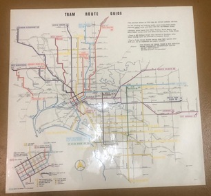 Melbourne Tram Museum
Map, Melbourne & Metropolitan Tramways Board (MMTB), "Tram Route Guide", Aug. 1979
Full colour map or poster printed on clear plastic with an adhesive peel off backing sheets, titled "Tram Route Guide". Map dated 8/79, showing proposed extension to Bundoora, routes with route numbers and names of main destinations. Has notes about the services, weekend and telephone numbers for information. 1979 2 copies held. See Reg Item 1098 for a smaller version of this map.trams, tramways, mmtb, map, routes, posters -
 Melbourne Tram Museum
Pamphlet, Prahran & Malvern Tramway Trust (PMTT), "Information for passengers - Round trip through Melbourne and Suburbs by Cable and Electric Tramways", c1918/19
Pamphlet - special size sheet, was originally folded into three titled "Information for passengers - Round trip through Melbourne and Suburbs by Cable and Electric Tramways", giving details of the trip, where the trams could be boarded, Description of Route, map shows the route along with other tram routes. Also show railway stations. Has a photo of a PMTT single trucker. c1918/19 2 copies held.trams, tramways, pmtt, cable trams, tours, round trip, map -
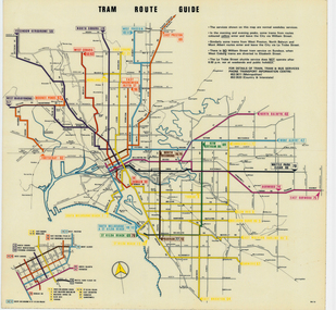 Melbourne Tram Museum
Map, Melbourne & Metropolitan Tramways Board (MMTB), "Tram Route Guide", Jun. 1979
Full colour map or poster printed on clear plastic with an adhesive peel off backing sheets, titled "Tram Route Guide". Map dated 6/79, showing proposed extension to Bundoora, routes with route numbers and names of main destinations. Has notes about the services, weekend and telephone numbers for information. 1979 Two copies held. See Reg Item 3765 for a larger version of this map.trams, tramways, mmtb, map, routes, posters -
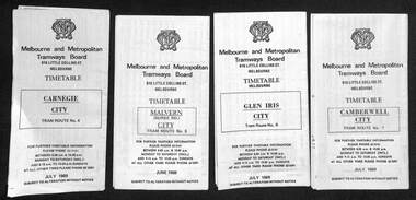 Melbourne Tram Museum
Ephemera - Set of 24, Melbourne & Metropolitan Tramways Board (MMTB), "MMTB Tram Timetables", 1969
Set of 23 timetables for specific routes, day of week giving information on tram times at specific time points, route map, sections and fares and organisation address - 616 Little Collins St. Melbourne. All July 1969. The first set of timetables issued in this format. 1- Route 4 - Carnegie - City 2 - Route 5 - Malvern (Burke Rd.) - City 3 - Route 6 - Glen Iris - City 4 - Route 7 - Camberwell - City 5 - Route 8 - Toorak - City 6 - Route 9, 10 and 12 - South Melbourne and St Kilda Beach - City 7 - Routes 10, 11, 9 and 9A - West Preston Northcote - City 8 - Route 1, 2A, 15, 16 - St Kilda Beach - South Melbourne - City 9 - Route 1, 15, 21, 22 - Moreland - East Coburg - City 10 - Route 19 - North Coburg - City 11 - Route 42 - Mont Albert - City 12 - Route 48, 74 - North Balwyn - Burwood - City 13 - ditto - Saturdays and Sundays - printed on pink paper 14 - Route 55, 56 - West Coburg - Domain Road - via William St 15 - Route 57 - West Maribyrnong - City - bus route Sundays only 16 - Route 59 - Essendon Aerodrome - City 17 - Route 64, 65 - East Brighton - via Swanston St/ William St 18 - Route 69 - Kew Cotham Road - St Kilda Beach 19 - Route 70 - Wattle Park - City 20 - Route 77, 78, 79 - Prahran - City, North Richmond - Prahran - St Kilda Beach 21 - Route 82 - Footscray - Moonee Ponds - bus route Saturday afternoon and Sundays 22 - Route 88 and Route 96 - East Preston, East Brunswick - city - July 1969, printed on white paper. - Weekdays and Sundays 23 - Route 88, 96 - East Preston and East Brunswick (Blyth St)< Saturdays, Xmas day and Good Fri - printed on pink paper. 24 - Route 4D - East Malvern (Darling Road) - City, bus route Sundays only Yields information about MMTB Tram services during 1969Set of 24 MMTB Tram timetables, folded sheets.trams, tramways, mmtb, timetables, melbourne, fares, route 69, route 64, route 88, route 96, route 4, route 4d, route 5, route 6, route 7, route 8, route 9, route 9a, route 10, route 11, route 12, route 1, route 15, route 21, route 22, route 2a, route 15, route 16, route 19, route 42, route 48, route 74, route 55, route 56, route 57, route 59, route 65, route 70, route 77, route 78, route 79, route 82 -
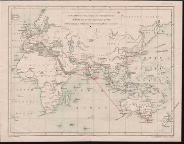 Bendigo Historical Society Inc.
Document - KELLY AND ALLSOP COLLECTION: MAP OF P & O SHIPPING ROUTES
Document. KELLY & ALLSOP COLLECTION. Map of Europe, Africa and Asia showing the shipping routes of the Peninsular & Oriental Steam Navigation Co. Routes highlighted in red. Produced by Nissen & Arnold, Fenchurch St., London. Date estimated as early 20th century.Nissen & Arnoldbusiness, stockbroker, kelly & allsop, kelly & allsop collection, p & o map, shipping routes, nissen & arnold. -
 Melbourne Tram Museum
Map, The Met, Public Transport Map of Melbourne - Get around on The Met, 8/1989
Melbourne transport map - dated August 1989 - zone ticket system, has a photo of the front of B2 2004, includes a map of the ticket zones, and The Met contact details.Yields information about Melbourne public transport services in August 1989.Fold out map (36 sections 9 across x 4 deep), "Public Transport Map of Melbourne", coloured of Melbourne's Tram and Bus routes, route numbers, rail lines, detailed for the central part of Melbourne and the outer Metropolitan services.tramways, melbourne, tram services, bus services, railways, maps, zones -
 Melbourne Tram Museum
Map, The Met, Public Transport Map of Melbourne - Get around on The Met, 12/1989
Melbourne transport map - dated December 1989 - scratch ticket system, has a photo of the front of B2 2004, includes a map of the ticket zones, and The Met contact details.Yields information about Melbourne public transport services in December 1989 following the introduction of Scratch tickets.Fold out map (36 sections 9 across x 4 deep), "Public Transport Map of Melbourne", coloured of Melbourne's Tram and Bus routes, route numbers, rail lines, detailed for the central part of Melbourne and the outer Metropolitan services.tramways, melbourne, tram services, bus services, railways, maps, zones, scratch tickets -
 Melbourne Tram Museum
Map, The Met, Public Transport Map of Melbourne - Get around on The Met, 8/1990
Melbourne transport map - dated August 1990 - includes a map of the ticket zones, and The Met contact details and notes where tickets can be obtained fromYields information about Melbourne public transport services in August 1990Fold out map (36 sections 9 across x 4 deep), "Public Transport Map of Melbourne", coloured of Melbourne's Tram and Bus routes, route numbers, rail lines, detailed for the central part of Melbourne and the outer Metropolitan services.tramways, melbourne, tram services, bus services, railways, maps, zones -
 Melbourne Tram Museum
Slide - Set of 5, Keith Caldwell, 1/11/1978 12:00:00 AM
Set of five Kodak Colour slides, cardboard mounts, by Keith Caldwell of: .1 - Z59 (East Brunswick, route 96) and Z41 (City route 88) in the Bourke St Mall, with the Buckleys and Myers buildings in the background. Dated 1.11.78. .2 - Z63 (East Brunswick route 96) and another Z at Swanston St in Bourke St with the Foys in the background. Also signs for Portmans, get smart clothing, Dated 1.11.1978. .3 - Z71 (City - Route 96) and another Z at the Spencer St stop, with the Eliza Tinsley building in the background. Dated 1.11.1978. .4 - Z71 (East Preston - Bell St - Route 89) and Z51 (East Preston Tyler St route 89) in Bourke St Mall, with Myers and the Post Office in the background. Dated 2.11.1978. .5 - Night photo of Z69, East Preston, at the Swanston St intersection? Has an illuminated sign for The Carlyon Hotel and South Cross Hotel in the backgroundDates as shown above in red ink.trams, tramways, bourke st, swanston st, z class, route 96, route 88, east brunswick, east preston, route 89, night photo, tram 59, tram 41, tram 63, tram 71, tram 69, tram 51 -
 Orbost & District Historical Society
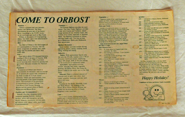
brochure, Come To Orbost, c 1980's
This brochure was produced as a tourist guide to Orbost.This item is a useful research tool.A magazine/brochure for use as tourist information. It contains the history, maps and touring routes of the Orbost district.tourism-orbost -
 Flagstaff Hill Maritime Museum and Village
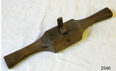
Spokeshave
Spokeshave, wooden & metal. Router blade. "J Glow" stamped on front and "R Crumble" on back.flagstaff hill, warrnambool, shipwrecked-coast, flagstaff-hill, flagstaff-hill-maritime-museum, maritime-museum, shipwreck-coast, flagstaff-hill-maritime-village