Showing 1783 items matching "settlement"
-
 Glenelg Shire Council Cultural Collection
Pamphlet, Historic Portland Buildings Open Day, 1970s
Camperdown and District Heritage Society, Collection.Two copies of black and white pamphlet to commemorate the first permanent settlement in Victoria, Historic Portland Buildings Open Day.Front: Black and white image of Gardens cottage Back: Black and white map of Historic Portland buildingshistoric buildings, buildings of portland, tourism, local history -
Glenelg Shire Council Cultural Collection
Medal - Medallion - centenary of Portland, 1934
Souvenir "Lt. James Grant 1800' on one side, 'Edward Henty / Centenary of POrtland Settlement 1834 - 1934' on the reversemedal, medallion, portland centenary -
Bendigo Historical Society Inc.
Map - BENDIGO IRRIGATION SETTLEMENT, 12/02/1908
Map: Plan of Bendigo Irrigation Settlement, Parishes of Sandhurst and Wellsford, County of Bendigo ( number 160 in Map Cupboard 1)map, bendigo, irrigation settlement, bendigo irrigation settlement, parishes of sandhurst and wellsford, county of bendigo -
![Parish of Nunawading, County of Bourke showing land acquired under Closer Settlement Acts [C 1887]](/media/collectors/56f368632162f118acbff12e/items/60d923316e5f99545134f182/item-media/6147b12a4806c7ae686c24e4/item-fit-380x285.jpg) Whitehorse Historical Society Inc.
Whitehorse Historical Society Inc.Map, Parish of Nunawading, ca 1887
Parish of Nunawading, County of Bourke showing land acquired under Closer Settlement Acts [C 1887]Parish of Nunawading, County of Bourke showing land acquired under Closer Settlement Acts [C 1887] 1947 reprint.Parish of Nunawading, County of Bourke showing land acquired under Closer Settlement Acts [C 1887] parish of nunawading, box hill, maps, land settlement -
Lakes Entrance Historical Society
Book, Allard, Peter and Alues, Geoff, Border Tales - Stories from Genoa,Wangarabell, Wroxham.Timbillica, Maramingo, Nungatta, Wingan and Gipsy Point, 2000
A short history of the life and times of residents of Genoa, Victoria, and associated border settlements. Not indexed, but has comprehensive contents list.aboriginals, township, timber industry, transport -
Lakes Entrance Historical Society
Book, Douglas J G , Talent J A, Buchan Caves A Geological Discussion, 1977
A short history of the geology of the Buchan Caves in East Gippsland Victoria, discovery after European settlement, and development as a tourist attraction.genealogy, natural history, exploration, tourism -
Lakes Entrance Historical Society
Book, RM Young author, Hutchinson Group Pty Ltd publisher, Concise History of Australia and Australians, 1982
Based on the authors years of research this book records history from a tiny outpost of British settlement to a thriving modern nationISBN 0091378508 new updated edition 1982history -
 Orbost & District Historical Society
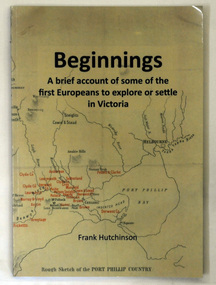
book, Beginnngs, 2011
"A map on the wall of his parent's shop in country Victoria is what got Frank Hutchinson interested in the geography and early settlement of Victoria. He later moved to Ballarat where he spent most of his working life. Whilst there his interest in the early explorers continued until about ten years ago he began to compile the listing which developed into the present publication." (ref.Port Phillip Pioneers Group) When he commenced the research and writing of Beginnings, it was not intended for publication. It was a project of personal interest. A soft covered 122 pp book title Beginnings a brief account of the first Europeans to explore or settle in Victoria. On the glossy front cover is a rough map of Port Phillip Bay. Print is black. a chronological list of the earliest visits to Victoria and attempts to settle. The book contains: brief notes on the exploration and earliest settlement of the state, region by region and a summary of the early Murray River paddle steamer industry.hutchinson-frank history-victoria prahran-mechanics-institute -
 Phillip Island and District Historical Society Inc.
Photograph, 1960
One of a collection of over 400 photographs in an album commenced in 1960 and presented to the Phillip Island & Westernport Historical Society by the Shire of Phillip IslandAerial photograph of the Cowes Kindergarten in Chapel Street, Cowes. Now next to the Cowes State School in Settlement Road. (JG 2017)local history, photography, cowes kindergarten, black & white photograph, kindergartens, chapel street cowes, john jenner, bryant west -
Bendigo Historical Society Inc.
Map - BENDIGO WEST IRRIGATION SETTLEMENT, 27/07/1910
Map: bendigo West Irrigation Settlement, Parish of Sandhurst, County of Bendigo. Parish plan ( number 193 in Map Cupboard 1)map, bendigo, irrigation settlement, bendigo west irrigation settlement -
Bendigo Historical Society Inc.
Map - BENDIGO WEST IRRIGATION SETTLEMENT, 13/02/1909
Map: Bendigo West Irrigation Settlement, Parish of Sandhurst, County of Bendigo. Parish plan. ( number 191 in Map Cupboard 1)map, bendigo, irrigation settlement, bendigo west irrigatioon settlement -
Bendigo Historical Society Inc.
Map - PARISH OF EGERTON, 19/03/1894
Map: Parish of Egerton, Settlement on Lands Act 1893, County of Bendigo. Parish plan ( number 245 in Map Cupboard 1)map, bendigo, settlement on lands act 1893, egerton, settlement on lands act 1893. -
Tatura Irrigation & Wartime Camps Museum
Folder, The Mighty Murray, 1993
Compiled by a group of teachers. Based on original concept by David Eastburn. Distributed as a teachers' aid. Assists in research developing their ability to formulate and test hypothesesRiver scenes (Murray and Darling). Educational information.|Includes aboriginal early population to present day settlement. Early map 1902the mighty murray, murray darling basin, huggan h, tatura, water, documents, education -
Clunes Museum
Pamphlet - LEAFLET
SHIRE OF TALBOT AND CLUNESBRIEF HISTORIC FACTS OF CLUNES, SETTLEMENT, GOLD , INDUSTRY, POPULATION, WATER SUPPLY TYPED ONTO FOOLSCAP PAPER, CARBON COPYNILlocal history, document, pamphlet, shire of talbot and clunes -
 Whitehorse Historical Society Inc.
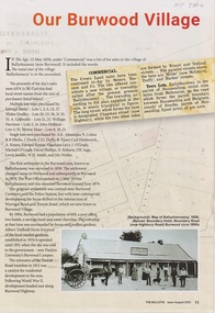
Article - The Bulletin newsletter, The Bulletin Jun - Aug 2022, Our Burwood Village, June 2022
An article about the first settlement surveyed in 1858 in the Burwood area known as Ballyshanassy. It later became Norwood and finally Burwood in 1879.An article about the first settlement surveyed in 1858 in the Burwood area known as Ballyshanassy. It later became Norwood and finally Burwood in 1879.An article about the first settlement surveyed in 1858 in the Burwood area known as Ballyshanassy. It later became Norwood and finally Burwood in 1879.ballyshanassy, albers ernest, boundary road burwood east, dempsey -
 Lakes Entrance Historical Society
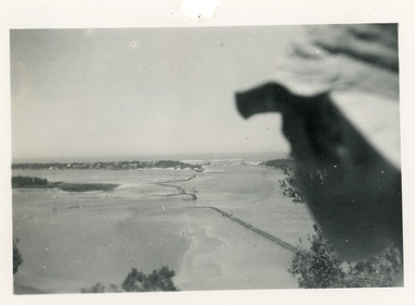
Photograph, 1950c
Black and white photograph of Bullock Island and rock groynes, Carpenter Town settlement at New Works, and the Entrance at Lakes Entrance, Victoriawaterways, dredging, islands -
Lakes Entrance Historical Society
Book, Morgan, Patrick, The Settling of Gippsland - A Regional History, 1997
A history of Gippsland from Aboriginal occupation to white settlement from the squatting years to present industry. Includes extensive bibliography, indexed.bibliography, aboriginals, settlers -
 Bendigo Historical Society Inc.
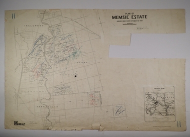
Map - MEMSIE ESTATE, 26/08/1905
Map:Plan of Memsie estate, aquired under Closer Settlement Act 1904. Parish plan. Map dated 26/08/1905.map, estate, memsie estate, closer settlement act 1904. -
Lakes Entrance Historical Society
Book, Frank Allen MBE, A Big Lookout, 1982
An authorative account of life and times of the Southern Monaro and South Coast from initial settlement until 1982. Illustrated with photographs, Indexedsettlers, genealogy, industrial -
 City of Moorabbin Historical Society (Operating the Box Cottage Museum)
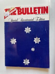
Book, Australian Consolidated Press Ltd, The Bulletin (Special Bicentennial Edition) January 26th.1988, 1988
A large dark blue soft cover book with the the title written in large red letters at the top,on a white stripe underneath this is written Special Bicentennial Edition and under this on the dark blue are five white stars depicting the Southern Cross four of the stars has the face of a historical person on it and the fifth star has an old sailing ship.non-fictionbicentennial, settlement, politics, religion, sport, food, 1788, business, population, booms, anglo australia. -
Glenelg Shire Council Cultural Collection
Souvenir - Glass, c. 1984
Small, clear glass, Portland's 150th logo embossed in gold. Story of Portland's settlement on back of glass, gold, embossed. Gold rim.Front: 'Portland's - above logo, 150th Anniversary, 1984' - below logo gold, embossed -
 Victorian Aboriginal Corporation for Languages
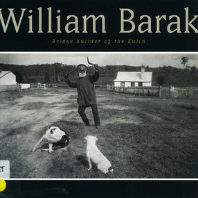
Book, Gib Wettenhall, William Barak : bridge builder of the Kulin, 2006
Detailed information about William Barak: his art, humanity and personal history, spanning the years of White Settlement and the political involvement with Coranderrk.b&w photographs, colour photographswurundjeri, william barak, coranderrk, yarra yarra -
Port Melbourne Historical & Preservation Society
Article - Newspaper article, Bend worker's homes still a dream, The Herald, Bend worker's homes still a dream, 1 Feb 1940
"Bend worker's homes still a dream" Cutting from The Herald, February 1 1940 The building of Fishermen's Bend housing settlement not progressing.built environment - domestic, fishermans bend, miss jean daley, labor women's central organising committee, australian labor party, henry peter zwar -
Lakes Entrance Historical Society
Book, Butlers Wood's Point and Gippsland General Directory, 1985
Facsimile edition of Butlers Gippsland Directory of 1866. Includes businesses, banks, postal officers, churches, and general information on all settlements of the time.directories, township -
Lakes Entrance Historical Society
Book, Blakeman Elizabeth, Stories from Wairewia, 2017
A collection of oral and written aneedates and other documentation about life from settlement to recent times in the Wairewa Valley East Gippsland Victoriasettlers, education, arts -
 Mt Dandenong & District Historical Society Inc.
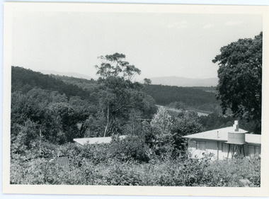
Photograph, View From Ernest Road To Site Of "Kia-Ora"
John Lundy-Clarke grew up in the Kalorama/Mt Dandenong area and later in life (1972-74) began to write a comprehensive history of the area working from an original settlement map in an effort to cover all areas. The photograph taken c1973 from Ernest Road looks over the site of the Kia-Ora guesthouse which is marked by the oalm tree that can be seen at the front of the flat roof close to the gum tree trunk. Situated on Barber’s Road, ‘Kia-Ora’ was built in 1912 by George Barber. It was later leased by a Mrs Pemberthy. “Kia-Ora’ was one of four places connected when the telephone was brought into the district in 1912. The other places were ‘Mountjoy’, ‘Cherry Farm’ and ‘Callum House’. ‘Kia-Ora’ was burnt down in 1924.Black and white photograph showing a house with water tank in right foreground and another flat roof centre foreground. There is a handwritten description by John Lundy-Clarke on the reverse.View 1973 from corner of Ernest Rd and Outlook Drive Lot 24 Village Settlement looking over the site of “Kia Ora” to the pioneers clearings. The palm tree seen above the flat roof (Rex) on left, is on the exact site of “Kia Ora”. Photo JLCernest road, john lundy-clarke, kia=ors, guest house, guesthouse -
Stawell Historical Society Inc
Book, Paul Hamlyn Pty, Ltd, Australia The First Hundred Years, 17.05.2021
Facsimile of Picturesque Atlas of Australia 1888. Bicentenary of Australia PublicationEditor: The Hon. Andrew Gartan M.A., L.L.D., M.L.C. A4 Mustard Cover Book Victoria P 151-254, 255-312. Stawell Lithograph P 275. Information p 277 - 278First Centuary of European Settlement - Inside Front cover. Berthing at Semi Circular Quay Sydney - end of Lithograph engravings.illustrated history -
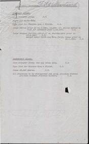 Bendigo Historical Society Inc.
Document - COHN BROTHERS COLLECTION: SHARE TRANSFER AND SETTLEMENT, 1961
A 14 page document covering the settlement and transfer of shares between A.H. Smith Ltd,. Cohn Brothers, Shepparton Cordials, and Reed Bros., also mentioned are Coca-cola assets, Bendigo Bottlers. Names mentioned are Mary Smith, Mahon Smith and F .Ballantine. The settlement also involves the resignation of Arthur Summers from A.H. Smith Limitedorganization, business, cohn brothers, cohn brothers , reed bros, coca cola , shepparton cordials, bendigo bottlers, a.h. smith -
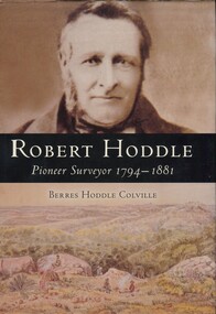 Surrey Hills Historical Society Collection
Book, Robert Hoddle: pioneer surveyor 1794-1881, 2004
(Ms) Berres Hoddle Colville is a local Surrey Hills resident and is a descendant of Robert Hoddle. Robert Hoddle was the first Surveyor General of Victoria. He arrived in Australia in 1823 and was one of the very earliest surveyors to explore, measure and map large areas of this vast, varied and difficult countryside, in a burgeoning era of pastoral settlement. 1837 saw him appointed Surveyor in Charge of the Port Phillip District. This book is based firmly on substantial extracts from Hoddle's own diary and other writings. Includes black and white sketches, maps and colour pages.Robert Hoddle was the first Surveyor General of Victoria. He arrived in Australia in 1823 and was one of the very earliest surveyors to explore, measure and map large areas of this vast, varied and difficult countryside, in a burgeoning era of pastoral settlement. 1837 saw him appointed Surveyor in Charge of the Port Phillip District. This book is based firmly on substantial extracts from Hoddle's own diary and other writings. Includes black and white sketches, maps and colour pages.Front endpaper: SURREY HILLS HISTORICAL / SOCIETY / PURCHASED FROM / THE AUTHOR ON THE OCCASION / OF HER TALK ON ROBERT HODDLE / TO THIS SOCIETY ON 17-10-[20]05 Title page: signed by the author: Berres Hoddle Colville / 17 October 2005 /(mr) robert hoddle, surveyors, (ms) berres hoddle colville -
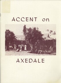 Bendigo Historical Society Inc.
Book - ACCENT ON AXEDALE, 1970
Accent on Axedale. Published by the centenary and back to Axedale Committee. Includes articles on early settlement, hotels, churches, industry, sporting clubs, Eppalock weir.foreword by Ian Smith.axedale, history, back to, axedale, hotel, church, school, back to, history