Showing 23160 items matching "side"
-
 Eltham District Historical Society Inc
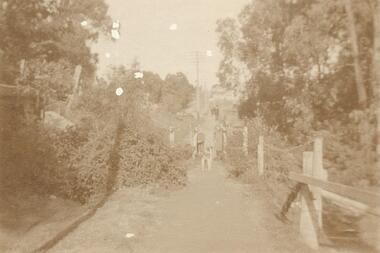
Photograph, Looking south along the east side of Main Road from Henry Street to Bridge Street, Eltham, February 1968, Feb 1968
Shows Warrens Fuel Merchant yard and Eltham Feed Store. Site of current Le Pine Funeral Home In February 1968 an unknown person took a series of photos from the Eltham Hotel at Pitt Street heading north along Main Road through the shopping centre to just north of Elsa Court covering the length of the section of Main Road which was duplicated shortly thereafter. Shows the condition and environment of the streesscape of Main Road, Eltham immediately prior to the duplication between Pitt Street and Elsa Court through the shopping centre. Also shows a number of shops and businesses that operated at that time.Black and white photographduplication, eltham, main road, briquettes, fuel merchant, le pine funeral home, york street, a.r warren, eltham feed store -
 Eltham District Historical Society Inc
Photograph, Looking north from the east side of Main Road between Henry and York Streets, Eltham, February 1968, Feb 1968
Eltham Shire Office and Shillinglaw trees to the left of photo In February 1968 an unknown person took a series of photos from the Eltham Hotel at Pitt Street heading north along Main Road through the shopping centre to just north of Elsa Court covering the length of the section of Main Road which was duplicated shortly thereafter. Shows the condition and environment of the streesscape of Main Road, Eltham immediately prior to the duplication between Pitt Street and Elsa Court through the shopping centre. Also shows a number of shops and businesses that operated at that time.Black and white photographduplication, eltham, main road, eltham shire offices, shillinglaw trees -
 Eltham District Historical Society Inc
Photograph, Our Lady's Church and school buildings on the east side of Main Road, Eltham, February 1968, Feb 1968
Shows car parking at left across Main RoadIn February 1968 an unknown person took a series of photos from the Eltham Hotel at Pitt Street heading north along Main Road through the shopping centre to just north of Elsa Court covering the length of the section of Main Road which was duplicated shortly thereafter. Shows the condition and environment of the streesscape of Main Road, Eltham immediately prior to the duplication between Pitt Street and Elsa Court through the shopping centre. Also shows a number of shops and businesses that operated at that time.Black and white photographduplication, eltham, main road, our ladys church -
 Eltham District Historical Society Inc
Photograph, Looking north along the east side of Main Road from near Henry Street, Eltham, February 1968, Feb 1968
Shows the Commercial Bank of Australia on the Dudley Street intersection and part of the War Memorial on the left amongst the parked cars.In February 1968 an unknown person took a series of photos from the Eltham Hotel at Pitt Street heading north along Main Road through the shopping centre to just north of Elsa Court covering the length of the section of Main Road which was duplicated shortly thereafter. Shows the condition and environment of the streesscape of Main Road, Eltham immediately prior to the duplication between Pitt Street and Elsa Court through the shopping centre. Also shows a number of shops and businesses that operated at that time.Black and white photographduplication, eltham, main road, commercial bank, eltham, dudley street, shire of eltham war memorial, arthur street, shopping centre, eltham shire office -
 Eltham District Historical Society Inc
Photograph, World War Two Memorial buildings on west side of Main Road, Eltham, February 1968, Feb 1968
Child Welfare Centre (opened 1952) and War Memorial Hall originally built for the Children's Library. Shows the Eltham Shire Office (built 1964) at left of photo.In February 1968 an unknown person took a series of photos from the Eltham Hotel at Pitt Street heading north along Main Road through the shopping centre to just north of Elsa Court covering the length of the section of Main Road which was duplicated shortly thereafter. Shows the condition and environment of the streesscape of Main Road, Eltham immediately prior to the duplication between Pitt Street and Elsa Court through the shopping centre. Also shows a number of shops and businesses that operated at that time.Black and white photographduplication, eltham, main road, shire of eltham war memorial, children's library, infant welfare centre -
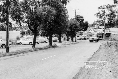
 Eltham District Historical Society Inc
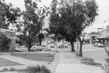
Photograph, Looking north along the west side of Main Road through the shopping centre, Eltham, February 1968, Feb 1968
Shows the pedestrian crossing to the Railway Station and car parking.In February 1968 an unknown person took a series of photos from the Eltham Hotel at Pitt Street heading north along Main Road through the shopping centre to just north of Elsa Court covering the length of the section of Main Road which was duplicated shortly thereafter. Shows the condition and environment of the streesscape of Main Road, Eltham immediately prior to the duplication between Pitt Street and Elsa Court through the shopping centre. Also shows a number of shops and businesses that operated at that time.Black and white photographduplication, eltham, main road, carparks, railway station, post office, shopping centre -
 Eltham District Historical Society Inc
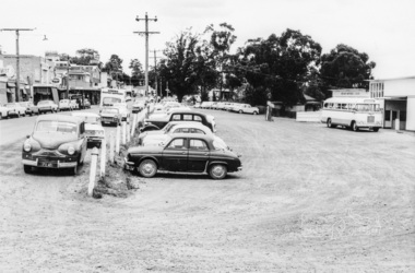
Photograph, West side of Main Road opposite main shopping centre, Eltham, February 1968, Feb 1968
Shows Eltham Post Office, Hairdresser and Tattersalls agency with Eltham Railway Station platform in background.In February 1968 an unknown person took a series of photos from the Eltham Hotel at Pitt Street heading north along Main Road through the shopping centre to just north of Elsa Court covering the length of the section of Main Road which was duplicated shortly thereafter. Shows the condition and environment of the streesscape of Main Road, Eltham immediately prior to the duplication between Pitt Street and Elsa Court through the shopping centre. Also shows a number of shops and businesses that operated at that time.Black and white photographduplication, eltham, main road, railway station, post office, hairdresser, tattersalls agency -
 Eltham District Historical Society Inc
Photograph, Looking south across to the shopping centre from the west side of Main Road, Eltham, February 1968, Feb 1968
Shows Bryant Motors beside Railway Station.In February 1968 an unknown person took a series of photos from the Eltham Hotel at Pitt Street heading north along Main Road through the shopping centre to just north of Elsa Court covering the length of the section of Main Road which was duplicated shortly thereafter. Shows the condition and environment of the streesscape of Main Road, Eltham immediately prior to the duplication between Pitt Street and Elsa Court through the shopping centre. Also shows a number of shops and businesses that operated at that time.Black and white photographduplication, eltham, main road, luck street, bryant motors, buses -
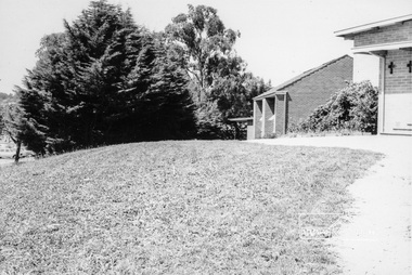
 Eltham District Historical Society Inc
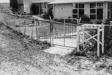
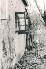
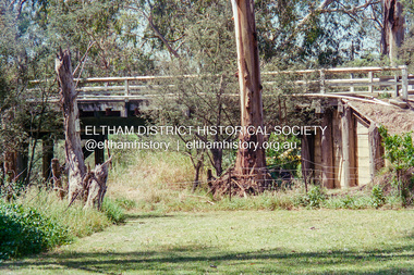
Photograph, South side of the house looking east towards brick storage shed, Eltham Living and Learning Centre
Black and white photographeltham living and learning centre -
 Eltham District Historical Society Inc
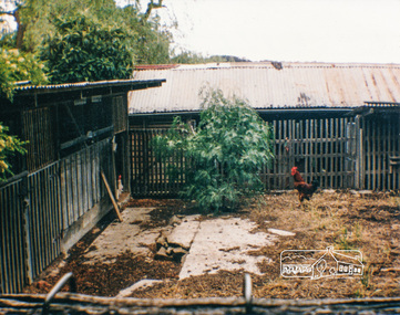
Photograph, Original Goat Shed and side of old storage shed shown on layout diagrams of site, Eltham Living and Learning Centre
Colour photographeltham living and learning centre, goat shed -
 Eltham District Historical Society Inc
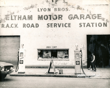
Photograph, George W. Bell, Lyon's Garage west side of Main Road Eltham, 1960c
Black and white photograph of Lyon Bros. Eltham Motor Garage 283-287 Main Road Eltham c.1960eltham, main road, automobiles, businesses, lyon, george w bell collection -
 Eltham District Historical Society Inc
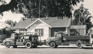
Photograph, Hugh Fisher, Eltham Fire Station, east side of Main Road, 1950s, 1950s
The Eltham Fire Station was opened in 31 April 1935. Years later the building was removed and erected for use of 1st Research Scout Group in Research Park by the early 1970s to make way for the Eltham Village Complex which was under construction by 1971. The Research Scout Hall was destroyed by fire in 2002.Black and white photographPhoto by Hugh Fischer, c.1950seltham, fire station, main road -
 Ringwood and District Historical Society
Photograph, Ringwood foot bridge, west side of Warrandyte Rd. 1919
Written on back of card, "Ringwood foot bridge, 1919". -
 Ringwood and District Historical Society
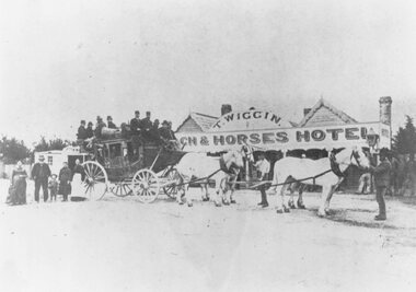
Photograph, Original Coach and Horses Hotel, south side of Whitehorse Road, Ringwood 1875
Inscription below photograph reads, "Original Coach and Horses Hotel, Whitehorse Rd. 1875". (Thomas Wiggin) -
 Ringwood and District Historical Society
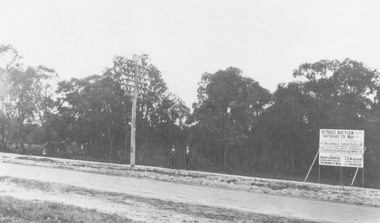
Photograph, Trees lining north side of Maroondah Highway between New Street and Ringwood Street, Ringwood - 1926. Auction Sale sign is shown on the eventual Holeproof factory site, later street numbered around 103 Maroondah Highway, Ringwood
Catalogue card reads, "Public Auction 1926. Saturday 29th May 1926. Holeproof factory once stood on this site. Billy Guyatt's discount store now occupies the site. (3 copies)". -
 Ringwood and District Historical Society
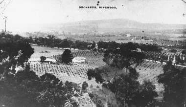
Photograph, View of Ringwood from Loughnans Hill. Pollards tank stand (centre) is on south side of Warrandyte Road. (Later location of Lauriston Crt.)
Black and white photograph looking down on orchards. House in centre of photograph, mountains in background. (3 copies)Written on back of one photograph, "Pollards tank stand" (centre) -
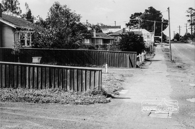
 Eltham District Historical Society Inc
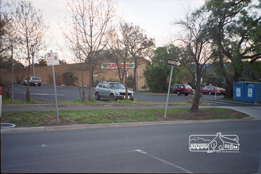
Photograph, Margaret Ball, Carpark, south side of Pryor Street, Eltham, June 1999, 1999
Original Safeway store, demolished July 2000The Margaret Ball (Pre 1960s Houses) Collection was a personal project initiated to mark the year 2000 and arose as a result of the disappearance of many pre-1960s parts of Eltham due to development. Approximately 200 pre-1960s style houses that were left in Eltham between Main Road and east to Bible Street, between Cecil Street to the north and south to Dalton Street were photographed in late 1999. Not all of the houses could be photographed; some because the garden or trees blocked the view of the house, others because of rubbish or cars were in the way, some because people were working on the house or in the gardens at the time.Roll of 35mm colour negative film, 10 stripsFuji 200eltham, houses, streets, margaret ball (pre 1960s houses) collection, pryor street, safeway store, carparks -
 Eltham District Historical Society Inc
Negative - Photograph, The old Wattletree Road bridge, Eltham on east side of Diamond Creek, 1998c
Viewed from the backyard of the Bakos family residence, 107 Railway Parade Eltham (formerly 137 Railway Parade Eltham) looking north.Roll of 35mm colour negative film, 8 strips and associated 10 x 15 cm colour printKodak Gold 100-5wattletree road, bakos residence, bridge, eltham, railway parade, wattletree road bridge -
 Eltham District Historical Society Inc
Photograph, Looking east from the northern side of Lower Plenty Road (opposite Bannockburn Road) as it crosses the Watsonia Drain, Viewbank, c.1965, 1965c
Transmission power lines visible in distance behind the Lower Plenty Hotel (in centre upper) and parts of Heidelberg Golf Club. In the foreground a bulldozer can be seen commencing roadworks for the re-alignment of Lower Plenty Road for the new Lower Plenty Bridge crossing.Medium format 120 6x6 black and white negative film, 1 frameheidelberg golf club, lower plenty, lower plenty hotel, road construction, viewbank, watsonia drain -
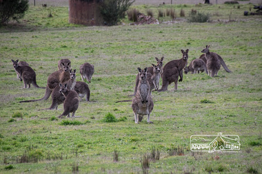
 Eltham District Historical Society Inc
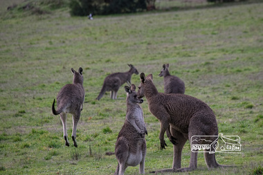
Photograph, Fred Mitchell, Kangaroos by side of road, Eltham North, 18 June 2016, 18/06/2016
Digital copy of colour photographfred mitchell collection, 2016, kangaroos, eltham north -
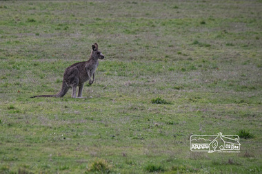
 Eltham District Historical Society Inc
Photograph, Fred Mitchell, Kangaroos by side of road, Eltham North, 18 June 2016, 18/06/2016
Digital copy of colour photographfred mitchell collection, 2016, kangaroos, eltham north -
 Eltham District Historical Society Inc
Photograph, Fred Mitchell, Kangaroos by side of road, Eltham North, 18 June 2016, 18/06/2016
Digital copy of colour photographfred mitchell collection, 2016, kangaroos, eltham north -
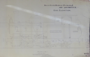 Federation University Historical Collection
Plan, Mount Lyell Railway (Tasmania) ABT Locomotive Side Elevation, undated
On 29 March 1893 the Mount Lyell Mining and Railway Company was formed. This Tasmanian mining company was often referred to as Mount Lyell. Mount Lyell, and was the dominant copper mining company of the Tasmanian West Coast from 1893 to 1994, and was based in Queenstown, Tasmania. After consolidation of leases and company assets at the beginning of the twentieth century, Mount Lyell was the major company for the communities of Queenstown, Strahan and Gormanston. It closed in 1994. The Mount Lyell mining operations produced more than a million tonnes of copper, 750 tonnes of silver and 45 tonnes of gold since mining commenced in the early 1890s – which is equivalent to over 4 billion dollars worth of metal in 1995 terms.Copy of a plan of a locomotive.mount lyell, locomotive, mount lyell railway, quuenstown, tasmania, strahan, gormamston, railway -
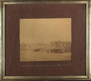 Federation University Historical Collection
Photograph - Sepia, Sturt Street North Side from Albert Street towards Grenville Street, 1864, 1864
Photographs of buildings in Ballarat's Sturt Street. Buildings include Central Tea Mart; Rockcliff.Doyle Family Grocers; Glennie's Boot Store. Solomon and Bardwell; Union Oil Co., ballarat, sturt street, solomon and bardwell, albert street, grenville street, solomon & bardwell, glennie's boot store, rockliff & doyle family grocers -
 Ringwood and District Historical Society
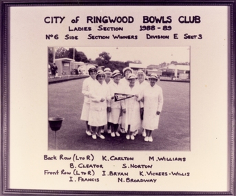
Photograph, Ringwood Bowling Club- Ladies Section, No 6 side, Section winners, Division E, Section 3. 1988-89
Black and white photograph"Attached to photograph" Players names: Back Row- L to R: K. Carlton, M. Williams, B. Cleator, S. Norton. Front Row- L to R: I. Bryan, K. Vickers-Willis, I. Francis, N. Broadway. -
 Ringwood and District Historical Society
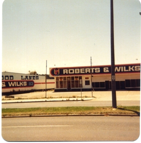
Photograph, Marondah Hwy, Ringwood, North Side - Roberts & Wilks Building c1979
Two colour photographs taken by Richard Carter, c1979 -
 Ringwood and District Historical Society
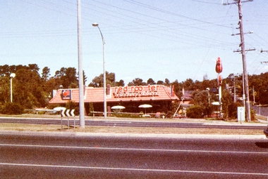
Photograph, Red Rooster Barbecued Chicken shop at the corner of Cutts Avenue and Maroondah Highway, east side in 1985
Photo taken by Marion Mitchell (nee Robinson) in 1985. The shop was often pranked by removing the "s" from rooster. -
 National Vietnam Veterans Museum (NVVM)
Film - Film, DVD, National Geographic: Vietnam's unseen war, pictures from the other side
Photos and film taken by Tim Page in the Vietnam Warvietnam war, 1961 -1975, war photography -
 Monbulk RSL Sub Branch
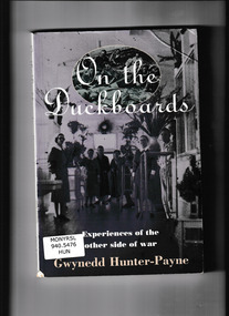
Book, Allen & Unwin, On the duckboards : experiences of the other side of war, 1995
The story of the Heidelberg Military Hospital during the second world warIndex, bibliography, notes, ill, p.220.non-fictionThe story of the Heidelberg Military Hospital during the second world warmilitary hospitals - australia - heidleberg, military nursing - history -
 Victorian Interpretive Projects Inc.
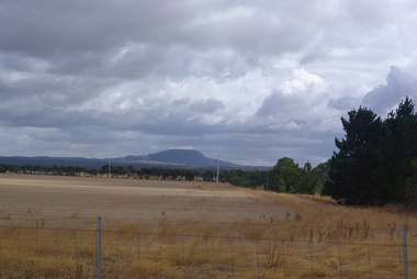
Photograph - Colour, Clare Gervasoni, Mount Buninyong from the Geelong side, 2014, 15/03/2014
View of Mount Buninyong from the road between Buninyong and Geelong