Showing 10757 items
matching site
-
 Mt Dandenong & District Historical Society Inc.
Photograph, Site of Jeannie Richardson's Home 1973
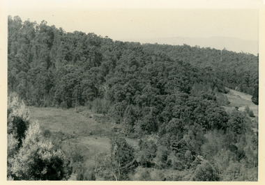
John Lundy-Clarke grew up in the Kalorama/Mt Dandenong area and later in life (1972-74) began to write a comprehensive history of the area working from an original settlement map in an effort to cover all areas. It was in the clearing on the left that John William (Willie) Richardson built a home for his wife Jeanie Green. It was called Mount Calvin. Jeanie was often ill and the family left the area seeking a warmer climate. They eventually settled in Brisbane. Willie sold the home and 60 acres around it to W. Rowse. Jeanie died in 1916. The remainder of the land was sold by solicitors to cover debts. Black and white photograph showing a treed hillside with a cleared area to the left hand side. Handwritten inscription on reverse by John Lundy-ClarkeLooking towards the site of Jeannie's home from near Doughty’s Road Nov 1973. Her house was in the centre of the clearing on the left. Photo Jan 1974 JLC.mount calvin, jeannie richardson, jeanie green, john william richardson, willie richardson, jeanie richardson, rowse -
 Port Melbourne Historical & Preservation Society
Document - Report, HMAS Lonsdale site development, Peter Brook, Design Director of Peddle Thorp Architects, HMAS Lonsdale Site - Drawing and photo report, Aug 2000
Report on proposed development of the HMAS Lonsdale site (south), prepared for C5 hearings, August 2000. Includes photographic views and architectural drawings. A3 horizontal, bound white plastic combtown planning, architecture, built environment -
 Falls Creek Historical Society
Document - Rating Assessment - Site No.4a
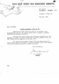
Bob (Herman) Hymans (a former member of the Royal Netherlands Navy) was born in Bloemendaal, Holland on 30th September 1922. During World War II he fought against the Japanese in the Dutch East Indies (now Indonesia) and was imprisoned in Changi and on the Burma Railway. After gaining qualifications as a Ski Instructor, Bob arrived in Falls Creek in July 1950. Working as an Instructor and Supervisor at Bogong Lodge, Bob decided his future was in accommodation. He was successful in negotiating an indenture for land from the State Electricity Commission (SEC). It took Bob two years to build his Grand Coeur Chalet but, tragically, it was burned down in August 1961. Bob also built the first Chairlift in Australia. This was a single chairlift and the structure was built from wooden electricity poles. He was constantly full of new ideas and proposals for the village. Bob Hymans died on 7th July 2007. This Collection of documents and letters tells the story of Bob's endeavours to develop Falls Creek into the ski village it is today.This item is significant because it documents actions taken by the Falls Creek Tourist Area Management Committee in their role overseeing the Tourist Area.A letter from the Management Committee accompanying rates assessment for Site 4A. Ratings were base on the number of beds in Mr. Hymans' accommodation. Rates also included a levy for garbage collection.falls creek tourist area management committee, falls creek administration, bob hymans -
Ballarat Tramway Museum
Newspaper, The Courier Ballarat, "Union to Press for New site for Tram Sheds", "Building Difficulties Tram Depot", Oct. 1947
Yields information about the moves to relocate the Ballarat Tram depot to a better location.Two Newspaper cuttings pasted onto a single foolscap sheet: Both from The Courier regarding a new near city site for the Tram Depot. "Union to Press for New site for Tram Sheds" - 29/10/1947 - quotes secretary of the Ballarat Union Branch, Mr. G. Hall, overcome wasted mileage. "Building Difficulties Tram Depot" - 31/10/1047 - regarding the Union suggestion - quotes Mr. T. A. L. Farr, SEC Branch Manager, problems of finding a site, large building and problems of obtaining materials due to their acute shortage - but that the Commission was "alive to the situation". Contained within Reg Item 5507 - Foolscap binder with green covers, black binding edge and metal clips. depot, depot offices, sec, atmoea, unions -
 Ringwood and District Historical Society
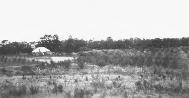
Photograph, Herman Pump's orchard and home Heathmont - 1923 - in vicinity of Royal Avenue. House on Canterbury Road, later site of Uniting Church
Black and white photograph of orchard. House in top left of photograph.Typed on backing sheet below photograph, "Herman Pump's orchard and home Heathmont - 1923 - in vicinity of Royal Avenue. House on Canterbury Road, now site of Uniting Church". -
 Ringwood and District Historical Society
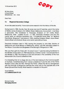
Document - Folder, Brief history of the Ringwood Secondary College site in Bedford Road, Ringwood, Victoria, since 1905 and subdivision in 1924
Terry Kane and Richard Carter were the authors of the short historyType written notes and plans pertaining to the land titles and history of the Ringwood Secondary College site from 1905, prior to the land being sold by the Borough of Ringwood in 1954 to the Education Department. Transcript of covering letter from Richard Carter to Mr T Kane dated 16 November 2012 - "Re: Ringwood Secondary College As we discussed recently, I have done some research into the history of the site. Going back to 1905, the site, then 26 acres one rood 37 perches, was in the name of Walter James Anderson of 61 William Street, Melbourne, Accountant - most likely a speculator. Title transferred to Theodosia Anderson of 167 Collins Street, Melbourne, Artist - possibly his son - In 1907. Theodosia Anderson was thus the owner when on abortive subdivision Into "110 Splendid Home Sites" as "Bedford Park Estate, Ringwood" took place In 1924, creating Anderson Street, Joyce Street, Adams Street and Graham Road, all of which sank without trace. Theodosia Anderson died In 1933, leaving the property to John Blair, Solicitor of Melbourne and Annie Benson of Melbourne, widow, until title ultimately passed to The Mayor, Councillors and Burgesses of the Borough of Ringwood In 1946. Title was then spilt Into three with 14 acres 0 rood 11 perches being transferred to the Minister of Education on 1954 followed by a further 2 acres 1 rood 26 perches to the Minister In 1956. The balance of the land remains In the ownership of the now Maroondoh City Council as Bedford Park. It Is Interesting that at no stage did any of the land belong to the Commonwealth of Australia, notwithstanding that I always understood It was the site of the P.M.G. Workers Camp after the War. Perhaps the P.M.G. utilized the site by arrangement with the borough of Ringwood; perhaps the camp was on the opposite site of Hill Street (Government Road). More research Is needed on this point. Yours faithfully, CE CARTER & SON PTY LTD Richard Carter Managing Director" -
Glenelg Shire Council Cultural Collection
Photograph, Softwoods Holdings Site, North Portland, April 1976, 1976
Port of Portland Authority archives.Back: Softwoods Holdings Site North Portland (lower left, pencil) APRIL, 1976 (lower left, blue pen) Portland Harbor Trust Commissioners (purple stamp, centre)port of portland -
 Whitehorse Historical Society Inc.
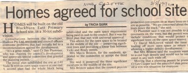
Article, Homes agreed for school site, 3/08/1994 12:00:00 AM
Subdivision of former Blackburn East Primary School Site,Article on development of 30 lot subdivision of former Blackburn East Primary School Site, Blackburn South. 1 - 41 Vicki Street. Developer Audcon Pty Ltd. In Nunawading Gazette 3 August 1994.Subdivision of former Blackburn East Primary School Site,blackburn east primary school, no. 4800, vicki street, blackburn south, bindy street, hudcon pty ltd, land subdivision -
Whitehorse Historical Society Inc.
Article, Homes for the aged on school site?, 1994
Proposal to develop 25 units for the aged on the original Vermont Primary School site. The community organisation, Vermont Elderly People's Homes has drawn up plans for the development on the corner of Mitcham and Canterbury Roads. With photo.vermont primary school, no. 1022, retirement homes and villages, vermont elderly peoples homes, barelli, ken, o'neill, ron, atkinson, bruce -
 Melbourne Tram Museum
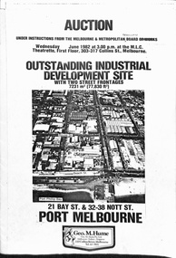
Pamphlet, Geo M Hume, "Auction - Outstanding Industrial development site - Port Melbourne", May. 1982
Draft of a pamphlet - folded A3 sheet for the sale in June 1982 of the former Port Melbourne Bus Depot, near the corner of Bay St and Beach St. Consists of two sheets of 150gsm ? paper bound together with an adhesive tape. A loose sheet showing the layout of the various titles included as well. Note the correction to the owners name from the MMBW to the MMTB. Includes an aerial photo of the site, photos of the buildings, addresses of the block, a site plan, title particular, terms of sale and the Vendors Agent, Geo M Hume.trams, tramways, mmtb, buses, sale of land, port melbourne depot -
 Ringwood and District Historical Society
Photograph, Old W T & HCO site looking to New and Seymour Streets, Ringwood 1980
Written on back of photograph, "Late 1980. Old W T & HCO site looking to New and Seymour Streets prior to development."SS0349g appears to have been cropped from SS0349g2 -
 Greensborough Historical Society
Photographs, Eltham Leisure Centre site: construction begins 1978, 1978_11
4 photographs of site preparation at the site for the Eltham Leisure Centre 1978, taken by Peter Graham, a Shire of Eltham Councillor. These photographs show heavy machinery preparing the site.4 colour photographs.peter graham, eltham, eltham leisure centre -
 Federation University Historical Collection
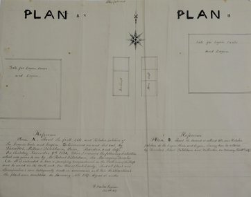
Plans, Site for Engine House and Engine, 1887
Two ink plan drawings, one with brown and grey shading, showing proposed sites and relative positions for an engine house and engine. .1) shows Plan A and Plan B options .2) shows elevations of brick engine houseengine house, robert ditchburn, w. watson, plans, mining -
University of Melbourne, Burnley Campus Archives
Plan, Burnley College Site, c. 1970 - 2001
Miscellaneous plans of the Burnley site with enlargements of sections. Roughly sorted. Different periods. Includes a map of Kew, and part of plan of Charman Ave., Emerald. Annotated plan of area of glass houses and chicken test pens ((1970 - 80?)burnley college, gardens, college buildings, kew, emerald -
 Ringwood and District Historical Society
Photograph, Looking to Adelaide St. from Reynolds Ave. Ringwood (across Mullum Creek) 1973. Site of bridge washed away in floods 1931. Infant Welfare Centre (Dr. Hewitts) on right
Black and white photographCatalogue card reads, "Looking to Adelaide St. from Reynolds Ave. (across Mullum Creek) 1973. Site of bridge washed away in floods 1931. Infant Welfare Centre (Dr. Hewitts) on right." -
 Ringwood and District Historical Society
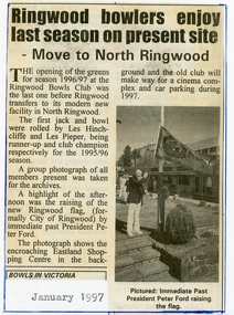
Newspaper, Ringwood Bowling Club- Last season on present site, January 1997
Newspaper cuttingHeading reads- Ringwood bowlers enjoy last season on present site. Move to North Ringwood. Image included in cutting shows Immediate Past President Peter Ford raising the new Ringwood flag. -
 Stawell Historical Society Inc
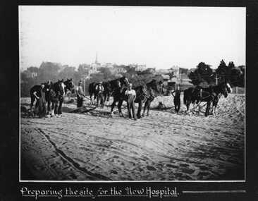
Photograph, Pleasant Creek -- Stawell Hospital site being prepared with workmen & horse drawn levellers
Pleasant Creek. Stawell Hospital Workmen on New Hospital Site preparing the site with horse drawn levellers.stawell hospital -
 Whitehorse Historical Society Inc.
Photograph, Site Office for the Construction of new crossing and station, 1/06/2009
One of a collection of photographs taken of the Nunawading Railway Station prior to the lowering of the railway line and building of the new railway station on the western side of Springvale Road so that the Springvale Road Rail Crossing can be eliminated. Black & white photograph of the precinct surrounding the Nunawading Station and the Springvale Road Railway crossing. This photograph is of the Site Office for the work associated with lowering of railway line and construction of new railway station. See NP 3545 to NP3567for the complete set of photographsnunawading railway station, redevelopment of railway line/springvale road., springvale road nunawading -
 Federation University Historical Collection
Photograph - Collection Storage, Federation University Cultural Collections at the Ballarat Off Site Store (BOSS)
The State Library of VIctoria Off Site Store is on the Mount Helen Campus and is known as the Ballarat Off Site Store (BOSS)A number of photographs of Federation University art and historical Collection after they had been tranferred to offsite storage at the Ballarat Offsite Store (BOSS)ballarat off site store, state library of victoria, ferderation university cultural collections, museum -
 Ringwood and District Historical Society
Pamphlet, Recognising Our Heritage - Archaeology assessment of Coach and Horses Hotel site, Ringwood, Victoria - 1999
A4 size information handout provided at RDHS guest speaker presentation "Archaeology in Ringwood" by Wren Lakeman (June 2023), talking about her work assessing archaeological significance of Eastlink Freeway/Tollway construction sites in accordance with Heritage Victoria requirements. -
 Whitehorse Historical Society Inc.
Photograph, Service Station -Now Works Site Office, 1/06/2009
One of a collection of photographs taken of the Nunawading Railway Station prior to the lowering of the railway line and building of the new railway station on the western side of Springvale Road so that the Springvale Road Rail Crossing can be eliminated.Black & white photograph of he precinct surrounding the Nunawading Station and the Springvale Road Railway crossing. This photograph is former Service Station on west side of Springvale Road. Now works site office. See NP 3545 to NP3567 for the complete set of photographsnunawading railway station, springvale road nunawading, redevelopment of railway line/springvale road. -
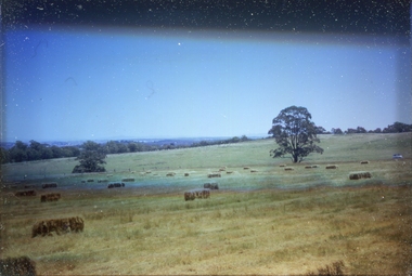 Federation University Historical Collection
Slide, Site of the Mount Helen Campus, 1967, 1967
The site of the Mount Helen Campus was purchased in 1967, with students on site from 1970. It had originally been the Latta/Downing farm. Two images of a farm at Mount Helen that was purchased for use as the Mount Helen Campus of the Ballarat School of Mines, later Ballarat Institute of Advanced Education. ballarat school of mines tertiary division, mount helen campus, ballarat institute of advanced education, farm, hay bales, agriculture -
 Federation University Historical Collection
Photograph, Site of Sovereign Hill and Ballarat Lodge
The Old Ballarat Travel Inn was located at 613 Main Road. It later Became Ballarat Lodge and Mecure Ballarat.Photograph showing the site of Sovereign Hill in fron to the pine trees, and Elsmore street running along the right. Ballarat Lodge, the brainchild of John Gilbert, can be seen in front of the dam in the centre. The start of Magpie Street can be seen on the left hand side of the photograph.ballarat lodge, john gilbert, sovereign hill, elsmore street, main road, ballarat east, old ballarat travel inn -
 Ballarat Tramway Museum
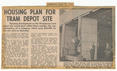
Newspaper, The Courier Ballarat, "Housing plan for tram depot site", 19/06/1972 12:00:00 AM
Newspaper clipping from The Courier, Ballarat, dated Monday, June 19, 1972 titled "Housing plan for tram depot site". Reports on the sale of the former tram depot on Saturday June 17 for $54,500. The purchaser expected to start development of housing on the site within three months. Reports on the sale, purchaser and SEC's views. Features a photo of Edgar Bartrop reading the contract. Others in the photo are Bruce Bartrop, SEC Estate officer, Mr. R. Morrison and SEC Manager Mr. I. F. Pellas. One of a large group of newspaper cuttings from John Bainbridge, 7/4/02.depot, buildings, auctions, bartrop -
Federation University Historical Collection
Document, Lake Bolac Camp Site
A report on the Lake Bolac Primary School as a school camp by Tony Gough and directed to Graham Beanland and Peter Shiells. The Ballarat School of Mines were looking for a camp site for the school bordering a State Forest. Also includes a comment by Colin McCurry of the Physical Education Department. lake bolac, school camp, colin mccurry, tony gough, graham beanland, peter shiells, pam davies -
Tatura Irrigation & Wartime Camps Museum
Document, Stefan Asboth and Arthur Knee, Camp 1 Tatura site inspection with Stefan Asboth May 28th 1989, May 28th 1989
Stefan Asboth retraced with Arthur Knee, the campsite and memories of the former, who was interned at Camp 1A clear plastic folder with a dark blue margin with white paper insert. Pale blue back cover. On the top right hand corner is a white self adhesive label on which is printed "Camp 1 Tatura site inspection with Stefan Asboth May 28th 1989"As abovecamp 1 tatura -
 Ballarat Heritage Services
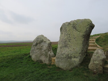
Photograph - Colour, Avebury World Heritage Site, Prehistoric Monuments, England, 2016
Colour photograph of the Silbury Hill, an immense Neolithic man-made mound part of the Avebury World Heritage Site. The Avebury World Heritage Site is a complex of outstanding prehistoric monuments comprising Windmill Hill (Early Neolithic enclosure and Bronze Age burial mounds); Silbury Hill; West Kennet Long Barrow; Avebury Stone Circles and West Kennet Avenue; The Sanctuary (site of stone and timber circles). It is part of National Trust and English Heritage. Visitors may walk to sites.Colour photograph of Avebury World Heritage Stte.avebury world heritage site, prehistoric monuments, rocks -
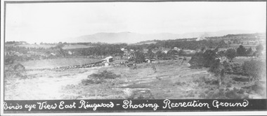 Ringwood and District Historical Society
Photograph, Birds eye view East Ringwood - Showing Recreation Ground. Mt. Dandenong Rd. on right. Taken from present Civic Centre site. Football final in progress - 1923
Written below photograph, "Birds eye view East Ringwood - Showing Recreation Ground". Typed below photograph, "Mt. Dandenong Rd. on right. Taken from present Civic Centre site. Football final in progress - 1923". -
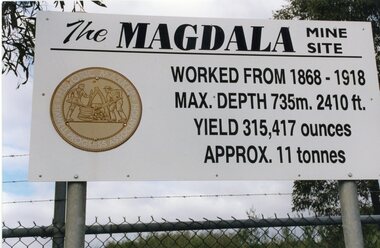 Stawell Historical Society Inc
Photograph, Kevin Patterson, Magdala Mine Site sign and Shaft, Circa 1999
3 Colour Photgraphs: 2 showing information about the mine , the other showing the shaft covered with protecive mesh.Sthe Sign Reads: The Magdala mine site worked from 1868 -1918. Max Depth 735 M. 2410 ft. Yeild 315,417 Ounces Approx 11 Tonnes On Revese: Gold Miners Stawell. Neg 20 mining, magdala -
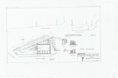 Ringwood and District Historical Society
Plan, Drill Hall Site - Design for Military Units and Miniature Rifle Range, Ringwood, Victoria - Circa 1935
Technical drawings (a) Block Plan - Ringwood Drill Hall Site, Station Street, Ringwood. (b) Plan View, End and Side Elevation, Drill Hall Wodonga - Removed to Ringwood. (c) Plan View, Front and Rear Elevations, Minature Rifle Range at Ringwood Drill Hall.Commonwealth of Australia. Department of The Interior, Works & Services Branch, Victoria.