Showing 255 items matching "stawell show"
-
 Stawell Historical Society Inc
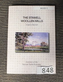
Book, Graeme Bennett, The Stawell Woollen Mills, 2013
The history of the Stawell Woollen MIllsOff white card cover with hatching, colour photograph of a Water colour painted by Will Rees 1922.Back shows Mill Garden ets c 1990The Stawell Woolen Mills Graeme Bennet Evolution of the Bennett Textile Business Page iii: For my Parents John and Jessie Bennett, my family and the people of Stawell Best Wishes thanks Graemestawell industry -
 Melbourne Tram Museum
Pamphlet, Yarra Trams, Tram Service Changes, 2022
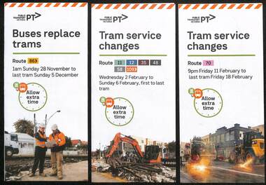
.1 - pamphlet provided at tram stops giving details of the works and bus services for 86 - Merri Creek Bridge works .2 - ditto - for provision of a super stop in William St at Collins St including replacement bus services on route 58 .3 - as for .1 - track reconstruction in Swan St between Stanley St and Stawell St Richmond or BurnleyShows the methods that Yarra Trams customers are advised of changes due to track replacement works..1 - Pamphlet - DL, three fold DL - Buses replace trams - route 86 - 28/11/2021 to 5 December 2021 - Route 86 .2 - Pamphlet - DL, four fold DL - Tram Service changes 2/2/2022 to 6/2/2022 - Routes 11, 12, 35, 48, 58 and 109 .3 - Pamphlet - DL, four fold DL - Tram Service changes - 11/2022 to 18/2/2022 - Route 70tram works, track work, route 58, yarra trams, ptv, route 86, merri creek, bridges, super stops, trams, tramways, richmond, burnley, route 70, collins st, william st -
 Melbourne Tram Museum
Pamphlet - Tram works on Swan St, Yarra Trams, Tram Service Changes, 2022
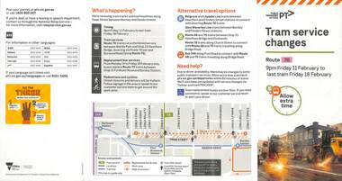
.1 - pamphlet provided at tram stops giving details of the works for 70 .2 - ditto - for Tram Network Upgrade - Swan St and Wallen Road Bridge, Richmond .3 - as for .1 - track reconstruction in Swan St between Stanley St and Stawell St Richmond or BurnleyShows the methods that Yarra Trams customers are advised of changes due to track replacement works. .1>.2 - Pamphlet - DL, four fold DL - Tram Service changes - 11/2022 to 18/2/2022 - Route 70 .3>.4 - Pamphlet - DL, four fold DL - Tram Network Upgrade - Swan St and Wallen Road Bridge, Richmond .5 - Newspaper clipping - Tram works on Swan Sttram works, track work, yarra trams, ptv, bridges, trams, tramways, richmond, burnley, route 70, wallen road bridge -
 Stawell Historical Society Inc
Map, P Jones, Shire of Stawell Roads and Reserves, 1989
Shows Woodlands Forests & Open WoodlandTwo Copies (2) map With roads around Stawell. Forests Woodlands 2 Very open Woodlands Coloured.Drawn P Jones. May 1989. Last Amended 25 may 1989 -
 Stawell Historical Society Inc
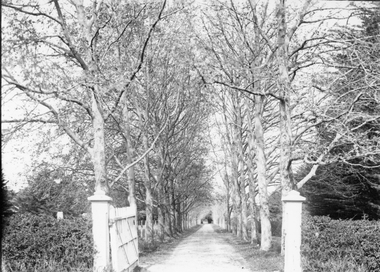
Photograph, “The Sycamores” Driveway entrance Gates
Entrance gates to “The Sycamores” Driveway. A show place on Concongella from mid 1860's. "The Sychmores" where William Osmand lived. Osmand's "Sycamores" was in a secluded block of the eastern side of the creek along which was planted pine and cypress trees. He built a comfortable house and line the carriage way with Sycamores. Osmand was on the of the men who made money in the Stawell reefs mines. "The Sycamores" has been owned by the West family since c 1920. Black & white photograph (2 copies) of an entrance gateway with an avenue of deciduous trees.concongella -
 Stawell Historical Society Inc
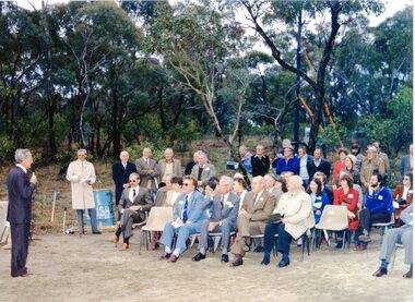
Photograph, Magdala Decline Opening 1981, October 1981
7081, WMC Manager Keith Parry addressing audience, Seated from L. Mine manager Brian Micke, unknown, unknown, Don Webb Seated far right Jean Earle Standing Pat Krause (bearded), John Van Leeuwen (hat and glasses) 7081a: Crowd Scene at the opening of the Magdala decline Front: L to R Eric and Hazel Lewis, Keith and Elwyn Haymes, Joan and Keith Hallam second row: unknown , unknown, Cynthia and Glynn Cashin, unknown , unknown third row: none known fourth row: Peter Ruthven, unknown, Jack Jones, Ken Dadswell at end, behind him Ian McCann Standing behind Mr and Mrs Kinsella on L. 5th from R. Terry Monaghan 7081b: Male Breaking ground with a Gold Pick (Mr David White, Minister for Minerals and Energy) 7081c: Catapillar Dozer digging the decline. 7081d: Conveyor belt moving soil with two workers 7081e: Underground Photo, a worker looking at drill placement. 7081f: The entrance to Magdala Delcine 1981. 7081g: A large dumper in the decline underground. 7081h: A Vehicle at the entrance to the Magdala Decline. 7081i: A Large group of miners around a vehicle at the entrance to the Magdala decline. 7081j: B/W showing a large rock with the dedication Plaque 7081K: Outside machinery for the drive. 7081l: Tanks containing liquid, one with the shell logo, and a red container. 7081m: Yellow tray truck emerging from the Magdala Decline. 14 Photographs showing crowd scenes at the Magdala Deline Opening in 1981 First shows CEO of WMC Keith Parry addressing the crowd Manager Brian Micke seated on far left Mayor Don Webb seated second from right7081k: On Reverse Stawell Gold MInes: Neg 26: 257 7081l: On Reverse Stawell Gold MInes: Neg 24: 257 7081m: On Reverse Stawell Gold Mines: Neg 25: 257 mining -
 Stawell Historical Society Inc
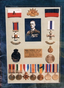
Photograph, Col. J.C.M. Traill DSO. MC - W W 1 & W W 2 medals in a frame
Framed photo and medals of both WW1 and WW2. Col. J.C.M. Traill DSO. MC.Colour photograph of medals and photo. Attention - President Historical Society Mr. Traill called - you weren't open. He asked me to give you this and he showed me his father's certificate (you said you would like to see?) for service rendered. Same as one hanging at present near photo copies in V.I.C. (Visitors Information Centre) Estelle Hirst. stawell military -
 Stawell Historical Society Inc
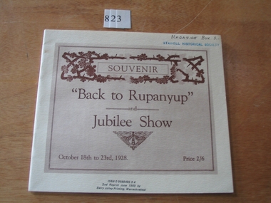
Book, L. H. Glasson, Back to Rupanyup and Jubilee Show, 1928
Early History of Rupanyup to 1928.Cream cover with rectangle with brown print and designSouvenir "Back To Rupanyup" and Jubilee Show October 18th to 23 1928 Price 2/6 ISBN 0 9589490 3 4 2nd Reprint June 1989 by Barry Jolley Printing, Warracknabealstawell -
 Stawell Historical Society Inc
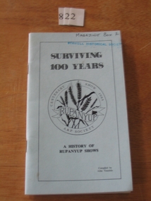
Book, John Teasdale, Surviving 100 Years, A History of Rupanyup Shows, 1985
... A History of Rupanyup Shows stawell Surviving 100 Years ...A History of Rupanyup ShowsPale blue cover with black line border inside which is title and wheat stalks inside a double circleSurviving 100 Years Centenary Show 1988 A & P Society Rupanyup A History of Rupanyup Shows Compiled by John Teasdalestawell -
 Stawell Historical Society Inc
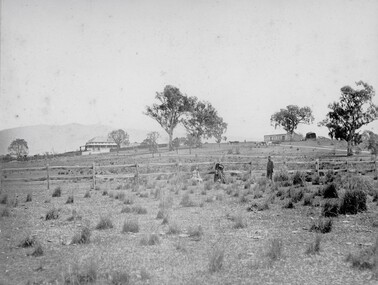
Photograph, Ledcourt Home Station in the Grampians 1866
... and some of the courtyard paving shows convict origin. Stawell ...Ledcourt Home Station Grampians. Part of a collection of Photographs by Mr. O.G. Armstrong as commissioned by the Shire of Stawell for the Inter-colonial and Paris Exhibition in Melbourne in 1866. This was one of, if not the first, Squatters Sheep Station in this region. The first licence of Ledcourt was granted to Robert Briggs in about 1840. In 1842 the run passed to Benjamin Boyd of Whaling and Boydtown Banking fame in NSW. He held it for six years. It was then taken over by Thomas Young and John Carfrae, who divided it into 3 holdings. Ledcourt 74,500 acres, Newington 74,500 acres and Swinton, 52,000 acres. It again changed hands in 1859, this time to Henry Alfred and Joseph De Little. It has changed hands several times since and in later years owned by the Cooper family and now the Marr family. The date of the actual building is uncertain, but it is known that the stone used in the building was carted from the Mount Difficult area in the Grampians and some of the courtyard paving shows convict origin. Looking up hill with Homestead on left and stone stables or right.stawell -
Stawell Historical Society Inc
Map, Stawell Gold Mines, Stawell Township 1995, 1995
Map shows details of mining activity Stockpiles, Tracks, Plant, Dams,, Waste, Tailing Dams, IronbarksPlain Printed Map in Black & White with details of MiningStawell Gold Mines Pty Ltdmining -
 Stawell Historical Society Inc
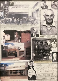
Photograph, Cooper/Newton Butchers Shop & Family Photo collage -- Coloured
Cooper/Newton Butchers Shop & Family. Framed Picture collage. Photograph compiled by Fay wife of Hartley Newton. The photo shows family member who carried on the butchering trade over many years. David Newton took over the business in Nov. 1997 and in 24.04.2013 was still running the only butcher shop in Stawell. Framed photographic collage of Cooper Brothers Butcher Shop and Newton's Butcher shop in Stawell. The collage has small and large photos of people and buildings plus a drawing of the Partick St butcher shop. stawell business shops -
Stawell Historical Society Inc
Photograph, Aerial Photo of Stawell 1981, 1981
Shows Railway Institute fire 1981. Swimming Pool in Cato Lake. Sawmill, King StreetVery Large Colour Print -
 Stawell Historical Society Inc
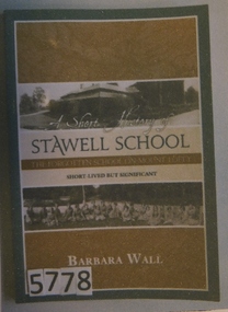
Book, Barbara Wall, A Short History Stawell School- The Forgotten School on Mount Lofty, 2012
A History of the Stawell School, (Mt Lofty S.A.) Green Card cover with white inner border two ochre panels seperated by two B/W photos and a awn panel containing text. The to photo shows a building, the lower phot in of a large group of girls sitting down outside,A Short History of Stawell School The Forgotten School on Mount Lofty Short Lived but Significant Barbara Walleducation -
 Stawell Historical Society Inc
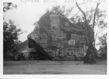
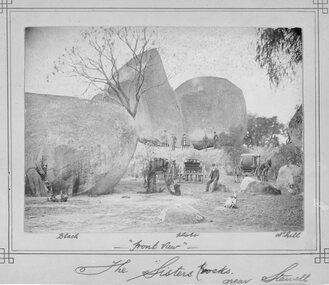
Photograph, Sister Rocks 1962
Sisters Rocks 1962 By Marion Mitchell-Robinson. The photo shows the graffiti on the north side of the rock. There is a dead tree to the right of the photo. This photo is of a well known land mark along the Western Highway. They take their name from 3 sisters named Levy, who camped there with their parents during the early days of Stawell.Black & White photo of Sister Rocks. "Sister's Rocks, Near Stawell" written on the front in biro. Inscribed on the back "Sisters Rocks Stawell Vic. May-June 1962 Taken c1962 by Marion Mitchell-Robinson".tourism -
 Stawell Historical Society Inc
Photograph, Photographer Black Photo Nhill, Sister Rocks c1880's, 1880's
Sepia photograph of the Sister Rock's with no graffiti therefore assume a very early photo. The view shows people standing on and around the rocks with three horse drawn Gigs in front of the rock's. c 1880'sSepia Photograph of the Sister Rock's. Very early photograph as no graffiti on the rocks. Black Photo Nhill "Front View" The Sister Rocks near Stawell - Langi Morgala Museum Ararat is stamped on the back stawell scenery -
 Stawell Historical Society Inc
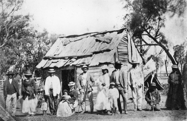
Photograph, Indigenous or First Nations People at Carrs Plains 1874 Richardson River Tribe
Photo taken at Carrs Plains in 1874 of Indigenous or First Nation People outside a wood and bark hut. In 1861, William Dennis of Carrs Plains Station, a staunch Methodist became Honorary, Aboriginal Protector for the area. One of his main tasks to give Government supplied food and clothing to the Aboriginals. Many district, remaining Aborigines became based at Carrs Plains, and their dead were buried in a cemetery on the station. The cemetery is show on survey map of Wirchilleva Borough, in corner of camping & water reserve near surveyed Bismarck township. In a Protector's report 1869, Dennis wrote that only one male worked regularly on the property, a Bullock driver.Black and white photograph of a wood and bark hut with a group of men, women and children out the front. Richardson River Tribe.Anthony & Lubra, Donald & Affie my ? Herbal? Black Billie Great Rider, Kitty Supulants? Lubra Jonny Callaghan Jr., Four? Supulant? Harry, Blind Tommy & Lubra, 1874 Reproduction rights reserved Copied by State Library of Victoriastawell aboriginal portrait -
 Stawell Historical Society Inc
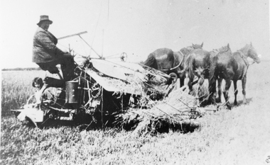
Photograph, Reaper and Binder being drawn by horses
Farming scene Horse drawn Reaper and Binder.Four black and white snapshots of harvest time. This photo shows two people, one driving the harvesting machine the other sitting on the back. Three horses are pulling the harvester that is cutting hay.stawell rural harvesting -
 Stawell Historical Society Inc
Photograph, Pioneer Walk Murals
27 colour photographs of the Pioneer Walk Mural displayed in Town Hall in 16.04.1992 prior to being installed in the "Pioneers Walk". Photos 322 - 12 to 14 shows the Pioneers walk way before a roof was placed over the walk way. The mural has been replaced. 322 Opening in Town Hall 16.04.1992, Wayne Kayler Thompson Mayor Cr. Bob Stone & Mrs Stone. 1. Opening speeches in Town Hall. Shire Councillor Laurie Delahunty & Marjory Delahunty. 2. Unveiling by project coordinator Jenny Munro. 3. First opening Town Hall 16.04.1992. This section of Mural was above entrance to Main Street. 4. First opening Town Hall 16.04.1992. 5. Another detail mural taken at Town Hall opening. 6. Mural detail 16.04.1992. 7. Photo of Bill Walker on left featured in Mural. 8. Opening in Town Hall. Mark Dadswell Times news Photographer. Herb Skurrie is featured in Mural & Helen Leach. 9. First opening, putting away at Town Hall. 10. Opening Town Hall 16.04.1992. 11. Detail of mural at opening 16.04.1992. 12. Another detail of boulders and steps in mural. Opening Town Hall. 13. Mural detail. 14. Mural on brick wall with Cate Whitehead, Jenny Munro and Peter Whitemead. 15. Mural detail opening Town Hall 16.04.1992. 16. Mural detail showing town hall drawing at first opening in Town Hall 16.04.1992. 17. Mural detail. 18. Detail in Mural at Town Hall opening 16.04.1992. 19. Edge of mural detail at Town Hall opening. 20. Lower detail of 322 (19) mural in Town Hall. 21. Mural detail Dedicated to the Pioneers of Stawell and Districts. Town Hall opening. 22. Mural detail displayed at Town Hall opening 16.04.1992. 23. Mural detail showing domestic scene and map of Stawell area at Town Hall opening. 24. Mural detail 1st opening at Town Hall. 25. Scene on mural show at 1st opening at Town Hall. 26. Photo showing one end of mural at 1st opening at Town Hall. 26 colour photographs of the pioneer walk "Murals"stawell -
 Stawell Historical Society Inc
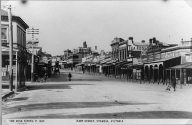
Photograph, Main Street Stawell looking East towards the Post Office
This photograph is of Main Street Stawell looking East around c 1920's. The photo was taken from just below Main & Wimmera Street corner. On the left side is the two story Post Office building. The photograph shows the telegraph poles in the street. Also Copley Post Office Hotel 1912- 22 and other business. On the road are a few people one pushing a trolly, one on a bike and two people in a horse drawn cart. Gustav Mahnke's Bakery is on right.Two Black & White photographs depicting the main street in Stawell's commercial business area in c 1920's. The view shows some two story buildings, shops with verandah's. One horse drawn vehicle, a person on a bike and a few people in the street. There is also a paper print of the photograph donated by Robyn Mackenzie Bacchus Marsh in 2009 The Rose series, P 1639 Main Street, Stawell, Victoriastawell business shops streetscape -
 Stawell Historical Society Inc
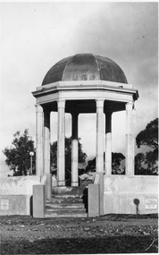
Photograph, Pioneers’ Memorial on Big Hill -- 3 Photos
Three black and white photos of Pioneers Memorial Stawell. The larger of the 4 photos is a Post card and taken earlier than the other 3 photos as there is a plastic milk crate over the area where the direction indicator was later placed. This photo also has "Chapman photo Stawell" stamped on the print. Two of the smaller photos show the Pioneer Memorial at a distance with people standing between the memorial and a bus parked to the left of the photograph. One of these two photos has a white seat on the right side. The fourth photo has "Murray View No. 8 Pioneers' Memorial, Stawell Vic". printed on the photograph of the Pioneers' Memorial. Each of the these 3 smaller photos have the direction indicator under the dome.Three black and white photos of Pioneers Memorial Stawell. The larger of the 3 photos is a Post card taken earlier than the other 2 photos as there is a plastic milk crate over the area where the direction indicator was later placed. This photo also has "Chapman photo Stawell" stamped on the print. Two of the smaller photos show the Pioneers' Memorial at a distance with people standing between the memorial and a bus parked to the left in the photograph. One of these two photos has a white seat on the right side. Each of the 2 smaller photos have the direction indicator under the dome.Chapman Photo Stawell (right bottom corner). Post Card printed on the back and also a stamp "Stawell district - Pioneer's Memorial - written inside the stamp is "Every blade of grass that grows And mullock heap and tree, Speak of Old days, the Good days, And times that used to be"stawell -
 Stawell Historical Society Inc
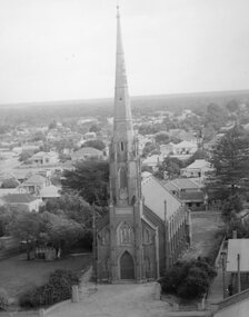
Photograph, St. Matthew’s Presbyterian Church
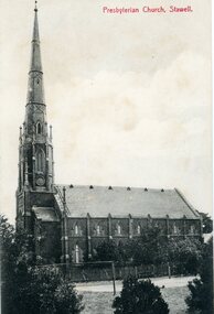
St. Matthew’s Presbyterian Church Stawell. Now United Church. This landmark of Stawell was opened on 11th April 1869. The tower and spire, overall height of 148 feet, cost 1352 pounds and was paid for by an early mine owner. In March 1869, a month before the Church was opened, the local paper reported that a large red flag on the top of the Presbyterian Spire meant that the last brick had been laid and the massive gilt ball and cross had been placed in position. The Church has some fine stained-glass windows. Two identical side views of a church with a tall steeple. These photos were taken from the original Post Cards in Album 13, p.41. The photo shows a Tennis Courts in foreground with a picket fence around the church. Presbyterian Church, Stawell written on the front of the post card and June' 09 Stawell written in pencil on the back. Post cards printed in Germany.stawell religion -
 Stawell Historical Society Inc
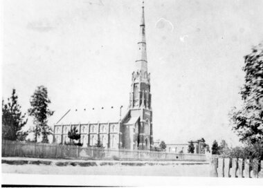
Photograph, St. Matthew’s Presbyterian Church
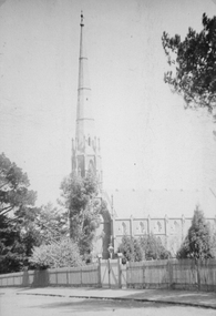
St. Matthew’s Church showing footpath and fence. The church is located in Scallon Street Stawell. St. Matthew's church was erected in 1868. The Spire was completed in March 1869 and the Church was dedicated on 11th April 1869. Now the United Church. Large photo of St. Matthew's Church taken from a post card in Album 13. p.28. The photo similar to 121.4 but shows the road, footpath and gate way in the picket fence with trees in the landscape.POST CARD The "Merle Studio" Main Street Stawell. stawell religion -
 Stawell Historical Society Inc
Photograph, St. Matthew’s Presbyterian Church from town hall clock tower c1959-1960
St. Matthew’s Church 1959-1960 taken from town hall clock tower. Photo taken around 1959 -1960. The Centenary book states brick fence and pillars were a gift from McCracken Family, but not in the year the church was built. This photo was used for the Centenary book cover and was taken from the Town Hall clock tower. The roof line in bottom right corner of photo is rear of town hall.Two photographs of St Matthew's Church taken from the Stawell Town Hall. The photo shows an aerial view of the church and houses behind the church. stawell religion -
 Stawell Historical Society Inc
Photograph, St. Matthew’s Presbyterian Church looking North
View of St. Matthew’s Church looking north. Shows Baptist Church (built 1869) in background on right.View of ST Matthew's Church looking north. a long wooden picket fence along the path in front of the church. A building in the background to the right of the church.stawell religion -
 Stawell Historical Society Inc
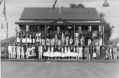
Photograph, Stawell Lawn Bowling Club Season Opening Day c1950's or 1960's
Stawell Bowling Club Season Opening Day. Large group of people on verandah of two storey Club house building with a line of people at lower level. Sometime in late 1950'sor early 1960's. Shows willow trees around Cato lake in background.stawell sport -
Stawell Historical Society Inc
Map, Borough of Stawell Parish of Stawell and Illawarra 10/06/1903, 10/06/1903
Department of Lands and Survey Map of Stawell with marked roads, allotments, physical landmarks. Found in Storage at ANZ Bank when the old archive was being cleaned out. Also shows Surveyed but unused roads. Showed where customers lived in StawellPholtolithograph Map - Paper on canvas backingBorough of Stawell. Parish of Stawell and Illawarra. County of Borong. Scale 8 Chains to 1 Inch. Scale 16 Chains to 1 Inch. Red Ink Writing, Purple and Blue.town -
 Stawell Historical Society Inc
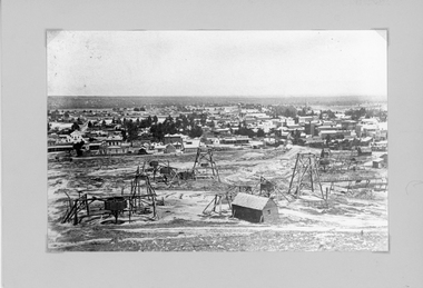
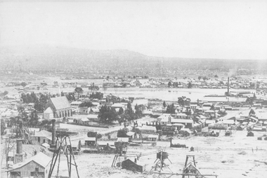
Photograph, Panorama of Stawell from Big Hill with Whims, Poppet Heads & Leaning Shed c 1878
Scene from Big Hill. Market Building in Skene Street at left of Stawell Court House. Businesses at corner of Sloane and Patrick Streets visible. Agnew Drapers store and buildings in upper Main Street visible Shows Mining activity in foreground 1878. Whim in foreground is No7 North Scotchmans and Whim next to that No8 North ScotchmansBlack & White Photograph from Big Hill. Market building left of Court house . Photo shows mining activity in the foreground, Stawell in the background c 1878. refer. Original c 1880 folder (room 2) from Don Rickard & Geoff Oates.stawell, panorama, streetscape, mining -
Stawell Historical Society Inc
Archive, Records of Stawell Sheep Breeders Assn – Minutes Books Correspondence Show Entries Programs Schedules Show Results 50th Anniversary Ribbons & Sashes, 1957 - 2006
Minute Books - Correspondence - Show Entries - Programs etc all in Bags Stored in Filing Cabinetstawell, agriculture -
 Stawell Historical Society Inc
Photograph, St. Patrick’s Catholic Church
... and surrounding buildings. The photo also shows mining operations... was commenced before the end of 1869. stawell panorama mining C. Herbert ...St. Patrick’s Catholic Church and surrounding buildings 1880's. The church was opened in 1873. The construction is of Black Ranges faced with Grampians Freestone. The bell tower is 70 feet high, and the walls are 30 inches thick. The church was opened on 30th March 1873 by the Bishop of Melbourne, the Right Reverend Dr. Goold. The Historical Society have a programme for this opening - tickets for front seats were 10/- each. The sanctuary was added during 1927 as was a white marble altar which was the gift of a parishioner. Much earlier - In 1865 - a wooden Catholic Church was built on this street near the Court House site. The wooden building became too small for the congregation and this church was commenced before the end of 1869. Sepia photograph of St Patrick's Catholic Church and surrounding buildings. The photo also shows mining operations in Stawell with the Grampians in the background c 1880's. Two enlargements of the Catholic Church are taken from the sepia photograph and marked as 105a.C. Herbert. Photo. Copyright Registered Stawell. on the back is written "Stawell from Big Hill c 1880" stawell, panorama, mining