Showing 516 items matching "strait"
-
 Lakes Entrance Historical Society
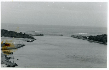
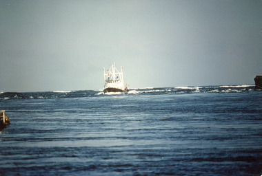
Photograph - The Entrance, 1986
Black and white photograph of the entrance from Bass Strait to the Gippsland Lakes. It also shows the rock groynes at Bullock Island filled with dredged sand to extend the island. Fishing boat coming through entrance. Lakes Entrance Victoriaislands, topography, waterways -
 Lakes Entrance Historical Society
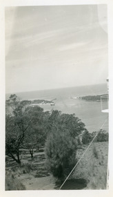
Photograph - The Entrance, 1950c
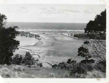
Black and white photograph of the man-made entrance from Bass Strait to the Gippsland Lakes, taken from the lookout tower on Jemmys Point. In foreground is the natural vegetation of Jemmys Point and a glimpse of the light beacon. Lakes Entrance Victoriaislands, waterways -
 Lakes Entrance Historical Society
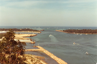
Photograph - The Entrance, 1979
The king of the straits, offshore powerboat race with Lakes entrance as a destination was not repeated due to adverse weather conditionsColour photograph of the entrance, Bullock Island and Reeves Channel. Taken from Jemmys Point during the King of the Strait offshore powerboat race. It also shows the built up groynes at the entrance to the North Arm. Lakes Entrance Victoriafishing industry, waterways, boats and boating -
 Lakes Entrance Historical Society
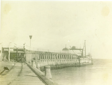
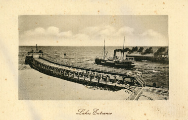
Photograph, Phillips Miss L, Entrance to Gippsland Lakes: Lakes Entrance, 1910c
Black and white photograph showing Eastern Pier and entrance to Gippsland Lakes from ocean - Bass Strait, photo shows work shed and crane on end of pier ready to build concrete extension on pier. Lakes Entrance Victoriapiers, ships and shipping, gippsland lakes -
 Lakes Entrance Historical Society
Photograph, Eastwood Bros, 1889c
Sepia photograph showing the just opened Entrance to Bass Strait. Sand not completely cleared from channel, buildings on dunes, dredge Wombat moored off Bullock Island. Rock groynes being built in lake. Lakes Entrance Victoriawaterways, islands, jetties, houses -
 Lakes Entrance Historical Society
Photograph - James Merlin, Fraser, Ian, 1989c
Colour photograph of the fishing vessel James Kerlin entering the lake from Bass Strait. On right of image is the end of western pier, behind James Kerlin surf is breaking on bar, in foreground calm entrance channel. Lakes Entrance Victoriafishing industry, ships and shipping, waterways -
 Lakes Entrance Historical Society
Photograph - The Entrance, 1920c
Black and white photograph showing entrance to Gippsland Lakes from ocean - Bass Strait. Photo shows rebuilt western pier with crane on end of pier, loose rocks. Launch - possibly Peels 'Blackbird' in the entrance. Lakes Entrance Victoria boats and boating, tourism, waterways, piers -
 Lakes Entrance Historical Society
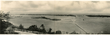
Postcard - Bullock Island, Bulmer H D No 15, 1930 c
Black and white double size postcard of Bullock Island. It shows a glimpse of the Princes Highway in foreground, wooden foot bridge to Bullock Island, houses on the hummocks, entrance and Bass Strait in background, boat entering lakes. Lakes Entrance VictoriaPanorama of Lakes Entrance from Princes Highwaywaterways, islands, township, civil engineering -
 Lakes Entrance Historical Society
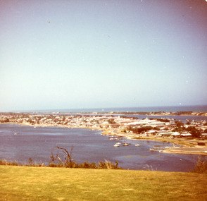
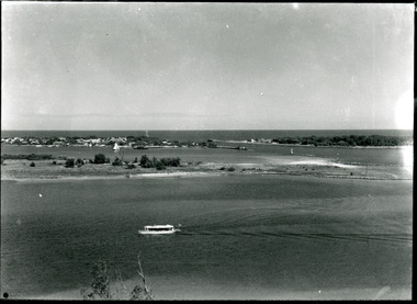
Photograph - Lakes Entrance, Fraser, Nancy, 1985c
Colour photograph of a bend in the North Arm. It shows the sports ground, eastern end of town. Jetties and hire boats at edge of lake. Photo taken from cleared hill, Kalimna, in foreground. Bass Strait in distance. Lakes Entrance Victoriawaterways, township -
 Lakes Entrance Historical Society
Postcard - S.S. Wyralla, 1920c
Postcard printed in Germany has serrated edging. Also another sepia toned copy 10 x 15cm.Black and white postcard showing SS Wyralla steaming out entrance into Bass Strait, lot of smoke. Workshed on end of eastern pier. No-one on piers or beach on left of eastern pier. Boardwalk on right on end of pier. Tramline visible. waterways, piers, ships and shipping -
 Lakes Entrance Historical Society
Photograph - Bullock Island, Silver Reflections Studio, 1920c
Black and white photograph showing Bullock Island, Entrance to Bass Strait, buildings on sand dunes, yacht sailing on Cunninghame Arm, tourist launch in foreground, rock groynes around west end of Bullock Island. Lakes Entrance Victoriawaterways, room display, islands -
 Lakes Entrance Historical Society
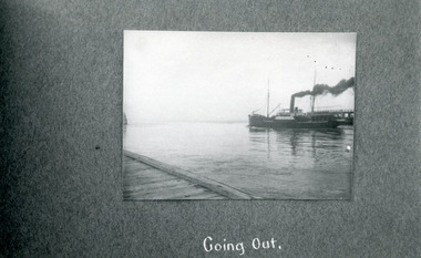
Photograph - SS Wyrallah, Phillips, Miss L, c1920
Black and white photograph showing SS Wyrallah going out the entrance from Gippsland Lakes to ocean/Bass Strait. Eastern pier boardwalk on left foreground, part of western pier showing behind steamer. Lakes Entrance, Victoria.Going Outwaterways, ships and shipping -
 Lakes Entrance Historical Society
Photograph - Boat ramp on North Arm Lakes Entrance Victoria, G W Holding, 1/04/1979 12:00:00 AM
Taken during King of the Straits power boat race Colour photograph taken from Kalimna Heights showing cars parked at boat ramp on North Arm rear entry to the Club Hotel Club Spit Cunninghame Arm outer barrier and Bass Strait in distance Lakes Entrance Victoria waterways, parks, boats and boating, boat ramp, houses, hotels, events -
 Lakes Entrance Historical Society
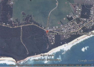
Photograph - Lake Tyers Beach, Google Earth, 2014
Colour photograph of Lakes Beachfront Holiday Resort showing Lake Tyers Beach Road, Barracouta Road and Salmon Road, walking track with ocean beach on Bass Strait in background, Bream Road in foreground, Lake Tyers Beach VictoriaLakes Beachfront Holiday Reocean, caravan parks -
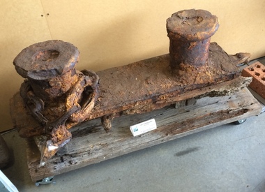 The Paynesville Maritime Museum
Bollard
This bollard is from the steamer "JCD" and served both to tie mooring lines and to feed them through. It was recovered from the MacMillan Strait some years after the "JCD" was removed from the water and burned.Cast iron bollard -
 Lakes Entrance Historical Society
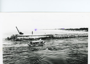
Photograph - The Entrance, Lakes Entrance Victoria. c 1979, G W Holding, 1/04/1979 12:00:00 AM
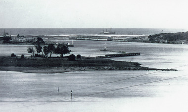
Also a colour photograph of similar view of event named King of the Straits. Not held again at this venue due to dangerous conditions in Bass Strait. number 04234.1 size 9 x 13 cmColour photograph showing the Entrance, power boats in the ocean contestants in the Offshore Powerboat Race hosted by the Gippsland Lakes Boating Club, six power boats in the lake. Good view of rock groynes at entrance to North Arm and clay and gravel filling on Bullock Island extension, Lakes Entrance Victoria. c 1979 waterways, events, boats and boating -
 Lakes Entrance Historical Society
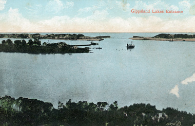
Photograph - The Entrance, 1910c
Colour tinted photograph of the entrance from Bass Strait to the Gippsland Lakes. It shows the small village on the hummocks, Bullock Island with bathing boxes at western end, machinery building groyne's from Bullock Island. Boat in the water. Lakes Entrance VictoriaGippsland Lakes Entranceislands, ships and shipping, topography, waterways -
 Lakes Entrance Historical Society
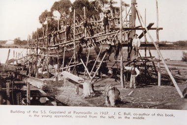
Photograph - Boat Building, 1907
Sepia photograph showing the steamer S S Gippsland being built at the shipyard at Paynesville. Hull and framework in progress, struts supporting hull in position, timber stacked on site, eleven workmen, McMillan Strait and Raymond Island in background. Paynesville VictoriaBuilding of the S S Gippsland at Paynesville in 1907. J C Bull co-author of this book is the young apprentice second from the left in the middle. ships and shipping, slipway, boat building -
 Lakes Entrance Historical Society
Photograph - Bullock Island, 1915c
On back of original 'To Rit with love from Arthur' (Arthur Seagrove - Head Teacher, Johnsonville Primary School - 1920)Black and white photograph of Bullock Island and the man-made entrance from Bass Strait. It shows the Western end of Bullock Island, some natural vegetation, jetty and timber groynes, trading vessel standing outside entrance. Lakes Entrance Victoriawaterways, islands, topography -
 Lakes Entrance Historical Society
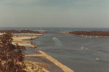
Photograph - The Entrance, 1995c
Colour photograph of the entrance from Bass Strait to the Gippsland Lakes, it shows the western end of Bullock Island and the built up area below Jemmys Point, both made during dredging operations over many years. Lakes Entrance Victoriaislands, fishing industry, waterways -
 Lakes Entrance Historical Society
Photograph - The Entrance, 1930c
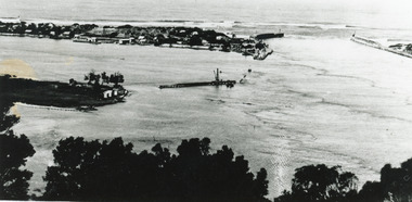
Black and white photograph showing wooden piers at entrance to Bass Strait from the Gippsland Lakes. Buildings on sand dunes, Bullock Island and rock groynes. Photo taken from Jemmys Point showing shrubbery in foreground. Lakes Entrance Victoriawaterways, topography, boats and boating, islands -
 Lakes Entrance Historical Society
Postcard - The Entrance, Valentine Series, The Entrance to the Gippsland Lakes, 1895c
Also a Black and white copy 11.5 x 18Colour tinted postcard of the entrance from Bass Strait to the Gippsland Lakes. It shows two small buildings on Bullock Island, groyne from Bullock Island across Cunninghame arm, sand inside entrance at western pier. Lakes Entrance VictoriaLakes Entrance from Jemmys Pointislands, topography, waterways -
 Lakes Entrance Historical Society
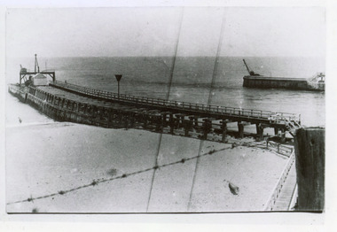
Photograph, Entrance to Gippsland Lakes: Lakes Entrance
Black and white photograph showing piers at entrance from ocean Bass Strait into Gippsland Lakes. Western pier on right shows new concrete extension completed. Eastern pier on left shows machinery and workshed. Strand of barbed wire fencing. waterways, piers, gippsland lakes -
 Lakes Entrance Historical Society
Photograph - Lakes Entrance, Gippsland Ports, 2006 c
Second copyColour aerial photograph of entrance from Bass Strait to Gippsland Lakes including Bullock Island Reeves Channel Rigby Island houses on Kalimna Hill and Princes Highway winding down Jemmys Point hill into township of Lakes Entrance Victoriaaerial photograph, ocean, waterways -
 Otway Districts Historical Society
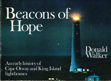
Book, Neptune Press Pty Ltd, Beacons of Hope, 1981
George Bass and Matthew Flinders made a voyage along the northern coast of Van Diemen's Land in 1798 to prove the existence of Bass Strait. The first vessel to attempt such a passage was the "Lady Nelson" under Lieutenant James Grant. Men sought out Bass Strait without the benefit of a lighthouse for the first half of the 19th Century after which, after several maritime disasters, on 29 August 1848, Cape Otway lighthouse commenced operation. Cape Wickham lighthouse, on King Island, joined its companion at Cape Otway on 1 November 1861.Beacons of hope. An early history of Cape Otway and King Island lighthouses. Donald Walker. 1st ed. Neptune Press; Belmont (Vic); 1981. ii, 154 p.; illus., maps, index. Soft cover. ISBN 0 909131 67 8Signed by author: Donald Walker.cape otway; king island; cape wickham; lighthouse; -
Port Melbourne Historical & Preservation Society
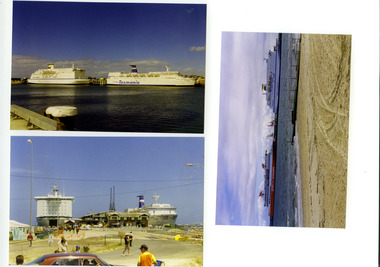
Photograph - Arrival at Port Melbourne, Spirit of Tasmania premier voyage, Devonport to Port Melbourne, David Thompson, 27 Nov 1993
When Mayor Liana Thompson and husband David flew to Devonport and took part in the premier voyage of the new Bass Strait ferry 'Spirit of Tasmania', David took this picture (Ref item 1087, souvenirs of trip)One of 12 photos of the premier voyage of 'Spirit of Tasmania', Devonport to Port Melbourne 27 November 1993: arrival at Port Melbourne; view to northwest of balloonstransport - ferries, celebrations fetes and exhibitions, spirit of tasmania, abel tasman -
 Port Melbourne Historical & Preservation Society
Photograph - Spirit of Tasmania and Abel Tasman, Devonport, Spirit of Tasmania premier voyage, Devonport to Port Melbourne, David Thompson, 27 Nov 1993
When Mayor Liana Thompson and husband David flew to Devonport and took part in the premier voyage of the new Bass Strait ferry 'Spirit of Tasmania', David took this picture (Ref item 1087, souvenirs of trip)One of 12 photos of the premier voyage of 'Spirit of Tasmania', Devonport to Port Melbourne 27 November 1993: 'Spirit' and 'Abel Tasman' at Devonporttransport - ferries, celebrations fetes and exhibitions, maritime, spirit of tasmania, abel tasman -
Port Melbourne Historical & Preservation Society
Photograph - Spirit of Tasmania and Abel Tasman, Devonport, Spirit of Tasmania premier voyage, Devonport to Port Melbourne, David Thompson, 27 Nov 1993
When Mayor Liana Thompson and husband David flew to Devonport and took part in the premier voyage of the new Bass Strait ferry 'Spirit of Tasmania', David took this picture (Ref item 1087, souvenirs of trip)One of 12 photos of the premier voyage of 'Spirit of Tasmania', Devonport to Port Melbourne 27 November 1993: 'Spirit' and 'Abel Tasman' at Devonporttransport - ferries, celebrations fetes and exhibitions, spirit of tasmania, abel tasman -
Port Melbourne Historical & Preservation Society
Photograph - Abel Tasman's last voyage, Spirit of Tasmania premier voyage, Devonport to Port Melbourne, David Thompson, 27 Nov 1993
When Mayor Liana Thompson and husband David flew to Devonport and took part in the premier voyage of the new Bass Strait ferry 'Spirit of Tasmania', David took this picture (Ref item 1087, souvenirs of trip)One of 12 photos of the premier voyage of 'Spirit of Tasmania', Devonport to Port Melbourne 27 November 1993: 'Abel Tasman' s last voyage, as seen from 'Spirit's' firsttransport - ferries, celebrations fetes and exhibitions, spirit of tasmania, abel tasman -
Port Melbourne Historical & Preservation Society
Photograph - Abel Tasman's last voyage, Spirit of Tasmania premier voyage, Devonport to Port Melbourne, David Thompson, 27 Nov 1993
When Mayor Liana Thompson and husband David flew to Devonport and took part in the premier voyage of the new Bass Strait ferry 'Spirit of Tasmania', David took this picture (Ref item 1087, souvenirs of trip)One of 12 photos of the premier voyage of 'Spirit of Tasmania', Devonport to Port Melbourne 27 November 1993: 'Abel Tasman' s last voyage, as seen from 'Spirit's' firsttransport - ferries, celebrations fetes and exhibitions, spirit of tasmania, abel tasman