Showing 840 items
matching subdivision plans
-
 Peterborough History Group
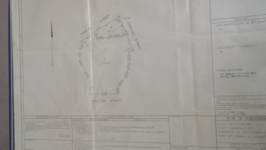
Map - survey of Hamilton St wetland, Plan of Subdivision Hamilton Street
... Plan of Subdivision Hamilton Street...A3 plan of subdivision showing the outline of the swamp..., Charles St and Cumming St. Plan of Subdivision Hamilton Street Map ...Subdivided to preserve the wetland, locals estimate it occurred between 1976 and 1983A3 plan of subdivision showing the outline of the swamp bounded by Hamilton St, Charles St and Cumming St. peterborough, survey map, golden pond -
 Whitehorse Historical Society Inc.
Map, Lake Road estate Blackburn, c1960
... Plan of subdivision of Lake Road Estate, 36 sites. Agent... Anjaya Court Blackburn Leons Court Blackburn Plan of subdivision ...Plan of subdivision of Lake Road Estate, 36 sites.Plan of subdivision of Lake Road Estate, 36 sites. Agent: Mark Padgett & Co Pty Ltd.Plan of subdivision of Lake Road Estate, 36 sites. lake road estate, blackburn, lake road, blackburn, ottawa avenue, blackburn, anjaya court, blackburn, leons court, blackburn -
Bendigo Historical Society Inc.
Map - KANGAROO FLAT SUBDIVISION, 26/11/1900
... Map: Plan of Subdivision at Kangaroo flat, Parish... of Bendigo Map: Plan of Subdivision at Kangaroo flat, Parish ...Map: Plan of Subdivision at Kangaroo flat, Parish of Sandhurst, County of Bendigo ( number 149 in Map Cupboard 1)map, bendigo, parish plan, kangaroo flat, parish of sandhurst, county of bendigo -
 Whitehorse Historical Society Inc.
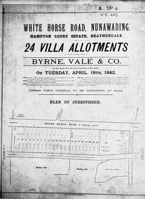
Document, Hampton Court Estate
... Plan of subdivision Hampton Court Estate Whitehorse Road... of subdivision Hampton Court Estate Plan of subdivision Hampton Court ...Plan of subdivision Hampton Court EstatePlan of subdivision Hampton Court Estate Whitehorse Road, Nunawading 1882. Original in Vale Maps LaTrobe LibraryPlan of subdivision Hampton Court Estate hampton court estate, byrne vale & co. -
 Whitehorse Historical Society Inc.
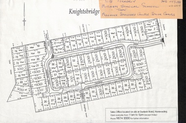
Map, Knightsbridge Estate, Nunawading, Ca 1997 - 1998
... Plan of subdivision of former Mitcham Technical School... Plan of subdivision of former Mitcham Technical School ...Plan of subdivision of former Mitcham Technical School and later Mullauna Secondary College Senior Campus - Knightsbridge Estate.land subdivision, knightsbridge estate, mitcham technical school, mullauna secondary college, senior campus, cherrybrook close, nunawading, knightsbridge avenue, sunnyside avenue, crest grove, dunlavin road, mitcham, carter avenue, humphreys avenue -
 City of Kingston
Pamphlet - Colour, Duffus Bros, Railway Reserve Highett, c. 1923
... along the middle of the plan, subdivisions 24 and half of 25... along the middle of the plan, subdivisions 24 and half of 25 ...Sales plan for land in the suburb of Highett, titled Railway Reserve, incorporating properties along Wolseley Street, Livingston Street, Highett Road and Worthing Road. The developing urban area of Highett within the City of Kingston. This land sale pamphlet illustrates the subdivision of land within the municipality and the changing demographic of the district as new houses and shops are constructed close to infrastructure.Colour pamphlet advertising thirty eight shop and villa sites for sale at the Railway Reserve, Highett. Incorporates a map of the reserve with properties available on Wolseley Street, Livingston Street, Highett Road and Worthing Road. Handwritten in grey pencil: assumed sale price recorded on subdivisions 1-7, 10, 22, 23 and 34 Handwritten in grey pencil on subdivision 4: C. Nevill / City of Melbourne bank Handwritten in grey pencil across subdivision 7: 49' Handwritten in grey pencil across subdivision 21 and 22: 134' Handwritten in grey pencil across subdivision 25 and 26: 200' Handwritten in grey pencil across subdivision 36 and 37 and both top and bottom: 120' Hand drawn in blue pencil: outline of subdivision 4 Hand drawn in blue pencil: outline of subdivisions 7, 23, 28, 37, 38 along left hand side, subdivisions 38, 37 and 36 on Wolseley Street, subdivisions 30 and 29 along Wolseley Street, subdivisions 29 and 24 along the middle of the plan, subdivisions 24 and half of 25 along Livingston Street, half of subdivision 20 along the middle of the plan, subdivisions 21 and 22 along the Right of Way between Livingston Street and Highett Road, and along the right hand border of subdivision 7. Handwritten in ink adjacent to the subdivision plan, updside down, in the bottom right hand corner: 276 / 54 / 280 / 45 / 320 / 202 / 200 / 134 / horizontal line / 11/14 Handwritten in ink adjacent to the subdivision plan, updside down, in the bottom right hand corner: 1714)2200(15 / 1714 / horizontal line / 486land sales, highett -
Ringwood and District Historical Society
Legal record - Conditions of Sale (C.E.Carter), Mitcham - Crown Allotment 124. M.E.Burke to ? Dated June 1st 1929
... and 45 on Plan of Subdivision 6736, Mitcham Road, Mitcham. Mrs... of Sale of Property , Lot 44 and 45 on Plan of Subdivision 6736 ...Particulars and Conditions of Sale of Property , Lot 44 and 45 on Plan of Subdivision 6736, Mitcham Road, Mitcham. Mrs M.E.Burke to ? -
Federation University Historical Collection
Plan, Plan of Mount Helen, 7/7/1964
... Plan of Subdivisions to Mount Helen, Shire of Buninyong... clear road Plan of Subdivisions to Mount Helen, Shire ...Plan of Subdivisions to Mount Helen, Shire of Buninyong, Sheet 1 and Sheet 2 Scale 200 feet to one inchmidland highway, gear avenue, eddy avenue, shire avenue, boak avenue, moss avenue, rathkeale avenue, ingliston avenue, chatham avenue, mardango drive, nyora grove, yarana drive, shakespeare avenue, marina avenue, landale avenue, lylia avenue, recreation road, olympic avenue, the gums, heather avenue, dallas avenue, jones avenue, sebastopol mount clear road -
Whitehorse Historical Society Inc.
Legal record - Document, Certificate of Title, 28/10/1913 12:00:00 AM
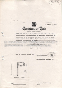
... Certificate of Title for Lot 41, Plan of Subdivision... of Victoria Certificate of Title for Lot 41, Plan of Subdivision ...Certificate of Title for Lot 41, Plan of Subdivision no. 2525, Deakin Street Mitcham, owned by State Savings Bank of Victoria.Certificate of Title for Lot 41, Plan of Subdivision no. 2525, Deakin Street Mitcham, owned by State Savings Bank of Victoria.Certificate of Title for Lot 41, Plan of Subdivision no. 2525, Deakin Street Mitcham, owned by State Savings Bank of Victoria.deakin street mitcham, state savings bank of victoria -
Whitehorse Historical Society Inc.
Legal record - Land Title, Certificate of Title, 1974 - 1998
... Certificate of Title: Vol 09048, Fol 467 Lot 1, Plan... of Title: Vol 09048, Fol 467 Lot 1, Plan of Subdivision 113045, 64 ...Certificate of Title: Vol 09048, Fol 467 Lot 1, Plan of Subdivision 113045, 64 Quarry Street, MitchamCertificate of Title: Vol 09048, Fol 467 Lot 1, Plan of Subdivision 113045, 64 Quarry Street, MitchamCertificate of Title: Vol 09048, Fol 467 Lot 1, Plan of Subdivision 113045, 64 Quarry Street, Mitchamquarry road, mitcham, no 64, land titles, mcclare, john, the glade, robertson, susan jayne, peter-budge -
Whitehorse Historical Society Inc.
Document, Title to 59 Mount Pleasant Road Nunawading, 1871 - 1992
... Copies of Title documents for Lot 3, Plan of Subdivision..., Plan of Subdivision 18705 for Section 117b, Parish ...Copies of Title documents for Lot 3, Plan of Subdivision 18705 for Section 117b, Parish of Nunawading from 1871 to 1992.Copies of Title documents for Lot 3, Plan of Subdivision 18705 for Section 117b, Parish of Nunawading from 1871 to 1992.Copies of Title documents for Lot 3, Plan of Subdivision 18705 for Section 117b, Parish of Nunawading from 1871 to 1992.mount pleasant road, nunawading no. 59, land titles, jones, dan, jones, anne -
Glenelg Shire Council Cultural Collection
Administrative record - Plans, n.d
... Black and white photocopy of old plan of subdivision, same... of old plan of subdivision, same as 8398, 8399, smaller scale ...Black and white photocopy of old plan of subdivision, same as 8398, 8399, smaller scale, numerous notations, added by Vanda Savill. -
Whitehorse Historical Society Inc.
Legal record - Land Title, Blackburn
... Plan of subdivision of part of Crown Portions 81,92 and 89... central road gordon crescent wolseley crescent Plan of subdivision ...Plan of subdivision of part of Crown Portions 81,92 and 89, Parish of Nunawading, County of Bourke. Photograph produced 11 Aug 1947.Plan of subdivision of part of Crown Portions 81,92 and 89, Parish of Nunawading, County of Bourke. Photograph produced 11 Aug 1947.Plan of subdivision of part of Crown Portions 81,92 and 89, Parish of Nunawading, County of Bourke. Photograph produced 11 Aug 1947.blackburn road, blackburn, wellington avenue, central road, gordon crescent, wolseley crescent -
 Whitehorse Historical Society Inc.
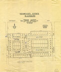
Map, Henwoods Estate, Blackburn
... Plan of subdivision in Blackburn South between Holland Road... street hearty street Plan of subdivision in Blackburn South Plan ...Plan of subdivision in Blackburn SouthPlan of subdivision in Blackburn South between Holland Road and Blackburn Road. Estate advertised by Spencer Jackson, 341 Collins Street.Plan of subdivision in Blackburn South land subdivision, henwoods estate, blackburn south, holland road, brazeel street, marama street, blackburn road, gissing street, hearty street -
Whitehorse Historical Society Inc.
Map, Burwood Road, Box Hill City, 15/02/1952 12:00:00 AM
... Plan of subdivision of ten blocks in Burwood Road, Burwood.... Marked as Survey Plan No 5441. Land Subdivision Burwood Road ...Plan of subdivision of ten blocks in Burwood Road, Burwood.Plan of subdivision of ten blocks in Burwood Road, Burwood between Milford Avenue and Station Street. Marked as Survey Plan No 5441.Plan of subdivision of ten blocks in Burwood Road, Burwood. land subdivision, burwood road, burwood, milford avenue, burwood, central court, burwood -
Whitehorse Historical Society Inc.
Map, Burwood Road, Box Hill City, 15/02/1952 12:00:00 AM
... Plan of subdivision of 19 blocks in Burwood Road, Burwood.... Marked as Survey Plan No 5442. Land Subdivision Burwood Road ...Plan of subdivision of 19 blocks in Burwood Road, Burwood.Plan of subdivision of 19 blocks in Burwood Road, Burwood between Greenwood Street and Middleborough Road. Marked as Survey Plan No 5442.Plan of subdivision of 19 blocks in Burwood Road, Burwood. land subdivision, burwood road, burwood, greenwood street, burwood, middleborough road, burwood -
 Kew Historical Society Inc
Photograph - Victorian Villa, High Street, c.1922
... Estate’ in East Kew occurred in 1922. [The subdivision plan... Subdivision plans are historically important documents used ...Subdivision plans are historically important documents used as evidence of the growth of suburbs in Australia. They frequently provide information about when the land was sold on which a built structure was subsequently constructed as well as evidence relating to surveyors and real estate and financial agents. The numerous subdivision plans in the Kew Historical Society's collection represent working documents, ranging from the initial sketches made in planning a subdivision to printed plans on which auctioneers or agents listed the prices for which individual lots were sold. In a number of cases, the reverse of a subdivision plan in the collection includes a photograph of a house that was also for sale by the agent. These photographs provide significant heritage information relating house design and decoration, fencing and household gardens.An old inscription on this photograph identifies it as ‘an elegant timber villa in High Street. It occupied part of Lot 91, bought by Edward Glyn in the land sale of 16th October 1851, and run as a flower farm’. The subdivision called the ‘Flower Farm Estate’ in East Kew occurred in 1922. [The subdivision plan is on the reverse of this photo.] The Estate included 61 lots on either side of Boorool Road between High Street and Harp Road. In the MMBW Detail Plan 2017 of 1926, a number of these new villas had already been built. Matching houses with MMBW maps can always be a challenge, however if this house was near the corner of Boorool Road and High Street, it seems to fit the profile of a house called ‘Maxton’ (demolished).Photographer's name on photograph, lower right, and stamp on mount lower right: "A. Aberline, Glenferrie".houses - maxton - high street - kew (vic.), violet farm estate, subdivisions - kew (vic.) -
 Eltham District Historical Society Inc
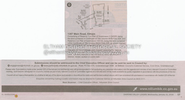
Document - Property Binder, 1307 Main Road, Eltham
... , Reserve 1 on Plan of Subdivision 213452R, Certificate of Title..., Reserve 1 on Plan of Subdivision 213452R, Certificate of Title ...Newspaper notice: Diamond Valley Leader, 31 January 2018, Calls for submissions re removal of reserve status and rezoning, Reserve 1 on Plan of Subdivision 213452R, Certificate of Title Volume 9879 Folio 829 and Reserve 2 on Plan of Subdivision 134133 Certificate of Title Volume 09434 Folio 620.main road, eltham, property -
Whitehorse Historical Society Inc.
Document, Certificate of Title, 21/07/1920 12:00:00 AM
... and 79, Plan of Subdivision no. 3212, Blackburn, owned by Thomas... Certificate of Title vol.4351 fol. 870161 for Lots 19 and 79, Plan ...Certificate of Title vol.4351 fol. 870161 for Lots 19 and 79, Plan of Subdivision no. 3212, Blackburn, owned by Thomas James HamiltonCertificate of Title vol.4351 fol. 870161 for Lots 19 and 79, Plan of Subdivision no. 3212, Blackburn, owned by Thomas James HamiltonCertificate of Title vol.4351 fol. 870161 for Lots 19 and 79, Plan of Subdivision no. 3212, Blackburn, owned by Thomas James Hamiltonhamilton, thomas james, station street blackburn -
Whitehorse Historical Society Inc.
Map, Mason's Paddock, Blackburn, 1919
... Mason's Paddock, Blackburn, plan of subdivision, 17 lots.... Mason's Paddock, Blackburn, plan of subdivision, 17 lots ...Mason's Paddock, Blackburn, plan of subdivision, 17 lots, realising auction, Saturday Nov 29, 1919.Mason's Paddock, Blackburn, plan of subdivision, 17 lots, realising auction, Saturday Nov 29, 1919. Agents T.R.B. Morton & Son.Mason's Paddock, Blackburn, plan of subdivision, 17 lots, realising auction, Saturday Nov 29, 1919. t.r.b. morton & son, blackburn, masons paddock, blackburn road, blackburn, masons road, blackburn, canterbury road, blackburn -
 Ringwood and District Historical Society
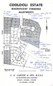
Document - Folder, Coolooli Estate Subdivision, Ringwood East, Vic. - Four Releases 1969-1975
... Collection of Subdivision Plans, Land Sale flyers, Auction... of Subdivision Plans, Land Sale flyers, Auction notices, and Real Estate ...Collection of Subdivision Plans, Land Sale flyers, Auction notices, and Real Estate Agent's notes for Coolooli Estate, Ringwood East, Victoria. Subdivision includes Coolooli Court, Isabel Avenue, Walhalla Drive, Cleland Street, Landell Court, Byways Drive, Heathwood Street and Hume Street, released over four stages - First Stage auction 16 August 1969, Second Release private sales from July 1970, Third Release Auction 11 September 1971, Final Release auction June 21st 1975. Agents - C.E. Carter & Son, 126 Whitehorse Road, Ringwood until moving to 122 Whitehorse Road in 1973 - Tel. 870 6024, 870 6830, 870 2519, A.H. 723 3298, 870 6960. Digitised copy of photograph - A.B. Carter and Andy McLean at Coolooli Estate auction, 11 September, 1971. -
Whitehorse Historical Society Inc.
Legal record - Land Title, Musk Street, Blackburn
... Rogers, 1955, with Plan of Subdivision CP 21670; 5. cadastral..., with Plan of Subdivision CP 21670; 5. cadastral map, AMA zone 55... Henry Rogers, 1955, with Plan of Subdivision CP 21670; 5 ...Land Titles referring to No. 1 Musk Street, BlackburnLand Titles referring to No. 1 Musk Street, Blackburn : 1. Vol. 542 Fol. 108222, James William Barnes, 1872; 2. Vol. 1877, Fol. 375367, Freehold Investment and Banking Company of Australia Limited, 1886; 3. Transfer 1507851 to John Thomas Williams, 1932; 4. Vol. 8109 Fol. 997 William Henry Rogers, 1955, with Plan of Subdivision CP 21670; 5. cadastral map, AMA zone 55, Sep 2000.Land Titles referring to No. 1 Musk Street, Blackburn musk street, blackburn, no. 1, maple street, blackburn, lawson street, blackburn, elder street, blackburn, barnes, james william, freehold investment and banking company of australia ltd, springfield road, blackburn, whitehorse road, blackburn, barnes estate -
 Whitehorse Historical Society Inc.
Document, Subdivision of part of W.B. Wickings Estate, 1952
... Plan of subdivision of part of W.B. Wickings Estate, 1952... benjamin Later subdivision Wicking Court. Plan of subdivision ...Plan of subdivision of part of W.B. Wickings Estate, 1952. Reticulation area 1457, Sewer through private property. Melbourne and Metropolitan Board of Works document.land subdivision, holland road, blackburn south, constance street, gissing street, rosen street, wicking court, melbourne and metropolitan board of works, sewerage and sanitation, wicking, walter benjamin -
Whitehorse Historical Society Inc.
Map, Parish of Nunawading, 1939
... Plan of subdivision part of crown portions 81, 82 and 89... of subdivision part of crown portions 81, 82 and 89, Plan of subdivision ...Plan of subdivision part of crown portions 81, 82 and 89,Plan of subdivision part of crown portions 81, 82 and 89, Parish of Nunawading, County of Bourke, Blackburn Wellington Avenue amended from Stanley RoadPlan of subdivision part of crown portions 81, 82 and 89, street names, parish of nunawading, blackburn road, blackburn, wellington avenue, blackburn, wolseley crescent, blackburn, gordon crescent, blackburn, clarke street, blackburn, central road, blackburn -
 Whitehorse Historical Society Inc.
Legal record - Document, Edgerton Road, 28/10/1958
... on Plan of Subdivision No 44073 (No 11) Edgerton Road, Mitcham... of Title Vol 8213, Fol 643 (Photocopy) Lot 10 on Plan ...Certificate of Title Vol 8213, Fol 643 (Photocopy) Lot 10 on Plan of Subdivision No 44073 (No 11) Edgerton Road, Mitcham. Transactions 1958 - 1988.edgerton road, mitcham, no 11, land titles, simpson, graham royal, biczok, iosif, dunne, rosemary geraldine -
 Eltham District Historical Society Inc
Document - Property Binder, 727 Main Road, Eltham
... Copy Certificate of Title, plan of subdivision Part... melbourne Copy Certificate of Title, plan of subdivision Part ...Copy Certificate of Title, plan of subdivision Part of Crown Portion 12 Section 4 Parish of Nillumbik County of Evelyn.main road, eltham, property, houses, shops, businesses -
Whitehorse Historical Society Inc.
Legal record - Land Title, Certificate of Title, 1919
... Lots 21 and 22 on Plan of Subdivision no. 6149 Crown... and 22 on Plan of Subdivision no. 6149 Crown Portion 89, Parish ...Lots 21 and 22 on Plan of Subdivision no. 6149 Crown Portion 89, Parish of Nunawading vol. 4192 fol. 838287, owned by State Savings Bank of VictoriaLots 21 and 22 on Plan of Subdivision no. 6149 Crown Portion 89, Parish of Nunawading vol. 4192 fol. 838287, owned by State Savings Bank of VictoriaLots 21 and 22 on Plan of Subdivision no. 6149 Crown Portion 89, Parish of Nunawading vol. 4192 fol. 838287, owned by State Savings Bank of Victoriablackburn road blackburn, walsham road blackburn, state savings bank of victoria -
Tatura Irrigation & Wartime Camps Museum
Poster, Tatura Subdivision, 1928
... Large Tatura subdivision poster of 1928 advertising large... Tatura was founded. tatura subdivision hogans estate Great ...Hogans Estate was privately owned land on Tatura's north side as opposed tot he government sub division when Tatura was founded.Large Tatura subdivision poster of 1928 advertising large area north of Hogan Street, named Hogan Estate. Clear plan of subdivisions. Bold print in red and blue.Great subdivision sale. Hogans Estate Tatura. Saturday 18 August 1928. J. McNamara & Co.tatura subdivision, hogans estate -
 Whitehorse Historical Society Inc.
Document, Mitcham, 1/03/1915
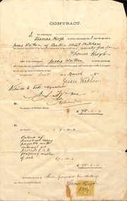
... , Parish of Nunawading, County of Bourke being Lot 6 on plan... of Nunawading, County of Bourke being Lot 6 on plan of subdivision ...Contract of sale of part Crown Portion 119,05 Mitcham, Parish of Nunawading, County of Bourke being Lot 6 on plan of subdivision No. 5339, by Thomas Keogh to Jessie Wathenland sales, wathen, jessie, keogh, thomas, mitcham -
 Kew Historical Society Inc
Plan - Subdivision Plan, J R Mathers & McMillan, Clutha Subdivision, 1940
... Subdivision Plan...The subdivision plan for the Clutha Subdivision is one... includes almost 100 subdivision plans pertaining to suburbs ...Pru Sanderson, in her groundbreaking ‘City of Kew Urban Conservation Study : Volume 2 - Development History’ (1988), summarised the periods of urban development and subdivisions of land in Kew. The periods that she identified included 1845-1880, 1880-1893, 1893-1921, 1921-1933, 1933-1943, and Post-War Development. These periods were selected as they represented periods of rapid growth or decline in urban development. An obvious starting point for Sanderson’s groupings involved population growth and the associated economic cycles. These cycles also highlighted urban expansion onto land that was predominantly rural, although in other cases it represented the decline and breakup of large estates. A number of the plans in the Kew Historical Society’s collection can also be found in other collections, such as those of the State Library of Victoria and the Boroondara Library Service. A number are however unique to the collection.The Kew Historical Society collection includes almost 100 subdivision plans pertaining to suburbs of the City of Melbourne. Most of these are of Kew, Kew East or Studley Park, although a smaller number are plans of Camberwell, Deepdene, Balwyn and Hawthorn. It is believed that the majority of the plans were gifted to the Society by persons connected with the real estate firm - J. R. Mathers and McMillan, 136 Cotham Road, Kew. The Plans in the collection are rarely in pristine form, being working plans on which the agent would write notes and record lots sold and the prices of these. The subdivision plans are historically significant examples of the growth of urban Melbourne from the beginning of the 20th Century up until the 1980s. A number of the plans are double-sided and often include a photograph on the reverse. A number of the latter are by noted photographers such as J.E. Barnes.The subdivision plan for the Clutha Subdivision is one of the largest in the Society’s collection. The plan includes a map of the proposed allotments, photographic views to the north and south, and information about the kinds of buildings that could be constructed on the allotments. The subdivision was bounded by Studley Park Road, and Carson, Stevenson and Edgecombe Streets. Two new streets, Mackie Court and Younger Street were created as part of the subdivision. The subdivision took its name from ‘Clutha’, the home of John Carson, who was to become Mayor of Kew in 1863. A Report to the City of Boroondara outlined how: ‘The Clutha estate was progressively developed from 1940, with new houses under construction on the Studley Park Road, Carson and Edgecombe Street frontages by 1941. By 1943, directory listings were available for all addresses with the exception of Mackie Court. Building ceased after the government’s prohibition on civilian building was enforced from 1942, with little change in listings until the 1950s when the remainder of the subdivision was developed’."H"subdivisions - kew - studley park, clutha subdivision, studley park road