Showing 91539 items matching "tambo-shire-history"
-
 Lakes Entrance Historical Society
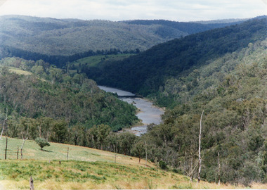
Photograph - Snowy River, Tambo Shire, 1994
Also second identical copyColour photograph of the Snowy River near The Basin, showing a river flowing between rocky banks, densely forested hills rising on both sides and into the far distance. Buchan Victoria topography, waterways -
 Lakes Entrance Historical Society
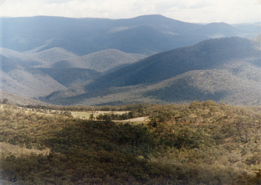
Photograph - Suggan Buggan, Tambo Shire, 1994 c
Also second identical copyColour photograph of the scenery in Suggan Buggan, showing very heavily forested mountainous country, a small area of cleared land centre left foreground. Suggan Buggan Victoriasettlement, agriculture, topography -
 Lakes Entrance Historical Society
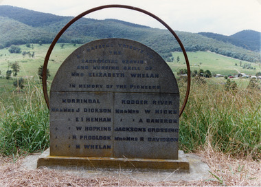
Photograph - Pioneer Memorial, Tambo Shire, 1994 c
Also second identical copyColour photograph of the roadside Pioneer Memorial at Murrindal near Buchan, Victoria.memorials, pioneers -
 Lakes Entrance Historical Society
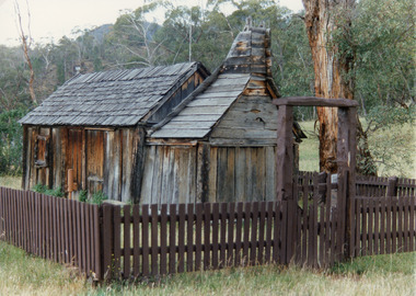
Photograph - Suggan Buggan School, Tambo Shire, 1994 c
Also identical copyPhotograph of the old school at Suggan Buggan. It shows a shingle roofed, timber slab building, large chimney area at one end, surrounded by timber fence set in bushland. Suggan Buggan Victoriaschools, buildings -
 Lakes Entrance Historical Society
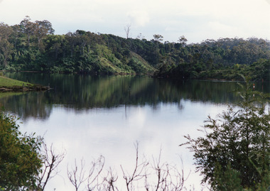
Photograph - North Arm, Tambo Shire, 1990c
Second copy image identical 20.5 x 28.5Colour photograph of a bay in the North Arm. It shows the calm waters of the lake surrounded by steep wooded banks, a grassy point with remains of fence or jetty. Reflections of surrounding vegetation in water. Lakes Entrance Victoria waterways, topography -
 Lakes Entrance Historical Society
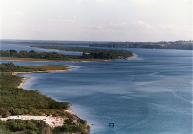
Photograph - Lake King, Tambo Shire, 1995c
Also second copyColour photograph of portion of Rigby Island, Fraser Island, and Flannagan Island, and Reeves Channel of Lake King, Gippsland Lakes. Steep shore of mainland in distance. Lakes Entrance Victoriaislands, waterways, topography -
 Lakes Entrance Historical Society
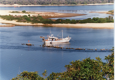
Photograph - Dredging, Tambo Shire, 1990c
Second copyColour photograph of the south eastern shore of Rigby Island, Gippsland Lakes. It shows the scrub covered hummocks in the background, Hopetoun Channel, dumped sand which connects Snake Island and Rigby Islands, groynes into Narrows from Rigby Island. Fishing boat with scallop dredge moored in sheltered bay inside a groyne. Lakes Entrance Victoria waterways, topography, fishing industry, dredging -
 Lakes Entrance Historical Society
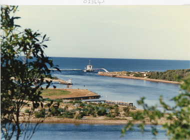
Photograph - The Entrance, Tambo Shire, 1990
Colour photograph showing the entrance to the lakes from Bass Strait, dredge April Hamer working on the bar. Western spit on right, eastern spit hidden behind bush, Bullock Island on left centre, mouth of North Arm in foreground, Lakes Entrance, Victoria.waterways, islands, township -
 Lakes Entrance Historical Society
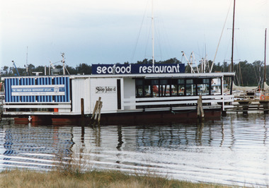
Photograph - Sloop John D Restaurant, Tambo Shire, 1990c
One other copy same sizeColour photograph of the Sloop John D seafood restaurant, moored on Cunninghame Arm. In the background are vessels in the boat harbour and the scrub covered hummocks of the southern shore. Lakes Entrance Victoriaboats and boating, township, waterfront, restaurant -
 Lakes Entrance Historical Society
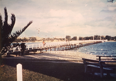
Photograph - Footbridge, Tambo Shire, 1985c
Colored photograph of footbridge over the Cunninghame Arm. It shows a flock of seagulls on the northern shore beside the approaches to the bridge, which has white painted railings, surf lifesaving club house on dunes in distance, several groups of people on footbridge. Lakes Entrance Victoriawaterways, bridges, tourism -
 Lakes Entrance Historical Society
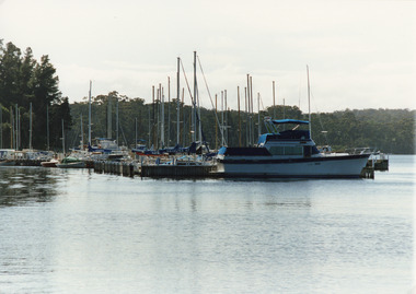
Photograph - Bancroft Bay, Tambo Shire, 1994
Also second identical copyColour photograph of Metung Marina on Bancroft Bay, showing yachts and cruisers moored at the jetties. Metung Victoriahouses, waterways, boats and boating -
 Lakes Entrance Historical Society
Financial record - Ledger, Country Roads Board Wages Ledger, 1953
A Ledger of Wages paid to Country Roads Board employees of East Gippsland VictoriaA Ledger of Wages paid to Country Roads Board employees of East Gippsland Victoriaaccounts book -
Lakes Entrance Historical Society
Financial record - Ledger, Country Roads Board Wages Ledger, 19450
Entries are hand written in ink. All pages are used. Leather bound, heavy cardboard cover, foolscap size.A ledger of wages paid to Country Roads Board employees of East Gippsland Regionaccounts book -
Lakes Entrance Historical Society
Administrative Record - Ledger, Pound Cash Book, 42108
Entries are hand written in ink on Gelantipy Pound proforma and glued to ledger pages, pages 1 to 14 have been used, leather bound with heavy cardboard cover, pages 15 to 145 are empty, there are also 15 blank proforma pages, contains some loose dockets.A ledger containing details of animals impounded by Gelantipy Poundaccounts book -
Lakes Entrance Historical Society
Financial record - Ledger, Country Roads Board Wages Ledger, 18050
Entries in ink and hand written, all pages used, leather bound foolscap sizeA Ledger of Wages paid to Country Roads Board employees of East Gippsland Victoriaaccounts book -
Lakes Entrance Historical Society
Administrative Record - Ledger, Poundkeepers Book, 20302
Entries are hand written in ink, pages 1 to 31 have been used, pages 31 to 97 are blank, Scale of Charges taped to inside cover, records across both page and facing page, 97 numbered leaves, leather bound with heavy cardboard coverA ledger containing details of animals impounded by Swan Reach pound during period December 1926 to 1955accounts book -
 Lakes Entrance Historical Society
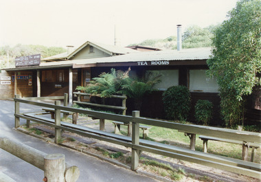
Photograph - Tea Room, Tambo Shire, kiosk on the hummocks. Lakes Entrance Victoria, 1980c
This is the before paired photograph used in the 150 year Lakes Entrance 1858-2008 display.|The after paired photograph number is 01544.1|Also one 12 x 16 framed photograph used in room display.Colour photograph of the kiosk on the hummocks. It shows the recently renovated and extended kiosk and garden, nestling beside the scrub covered sand hummock. Rustic picnic tables and seats inside garden grounds. Lakes Entrance Victoriawaterfront, restaurant -
Tatura Irrigation & Wartime Camps Museum
Document - Folder - Family History, Dowell Family History
Dowell family history. Contains certificates, photographs (copies), family tree and letters.Blue folder containing 3 sections: 3rd section contains 23 plastic sleeves containing photocopies of family history.Dowell Family Historydowell family, dowell family history, family trees -
Lakes Entrance Historical Society
Book, Content Pty Ltd, East Gippsland Shire Heritage Gaps Study Vol 3 Environmental History, 2005
A comprehensive study concerning the interation of people and the environment in the East Gippsland Shire. Subjects are covered from exploration and settlement to government, administration and cultural development.environment, township -
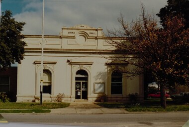 Stawell Historical Society Inc
Photograph, Stawell Shire Hall 1866 c1988 -- Coloured
Photograph of Stawell Shire Hall taken 1988. 1988 view of the Stawell Shire Hall. Photo taken from the other side of the road. The decoration on top of the building is missing. The tree on the right hand side is losing its leaves and 2 cars are parked on the right, behind the tree. Stawell Shire Hall 1988 Geoff Oates P.O. Box 402 Stawell.stawell -
Lakes Entrance Historical Society
Book, Davidson W H, Tales of Tambo Valley, 1981
This book attemps to capture some of the memories of a man whose life spans nearly 90 years of the Tambo Valley near Omeosettlement -
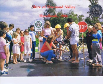 Greensborough Historical Society
Booklet, Shire of Diamond Valley Handbook 1986, 1986_
Guide to services provided by Shire of Diamond Valley. The Shire of Diamond Valley was a Local Government Area located about 20 kilometres northeast of Melbourne. The shire covered an area of 74.38 square kilometres and existed from 1964 until 1994. . Cover illustration of Bike Education program sponsored by Shire of Diamond Valley in local schools.Annual guide to services in Shire of Diamond Valley32 pages, col illus., maps. (3 copies)shire of diamond valley, greensborough, handbooks -
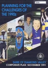 Greensborough Historical Society
Pamphlet, Planning for the challenges of the 1990s: Shire of Diamond Valley Corporate Plan, 1991_11
Shire of Diamond Valley Corporate Plan 1991. Includes Shire map and statistics with plans for services to the community.16p. text and coloured photographsshire of diamond valley -
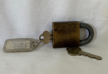 Greensborough Historical Society
Functional object - Padlock and Keys, Lockwood, Shire of Diamond Valley padlock and key and master key, 1960s
Shire of Diamond Valley Master Key and padlock and key, used by Shire staff between 1964 and 1994.Lockwood padlock and two keysshire of diamond valley, keys, padlocks -
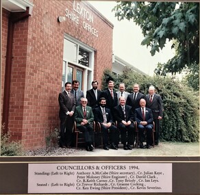 Pyrenees Shire Council
Photograph, Shire of Lexton Councillors and Officers
significant to the Pyrenees Shire and Lexton communityframed photograph of Shire of Lexton Councillors and Officers "Inscribed front: Shire of Lexton Councillors & Officers 1994" -
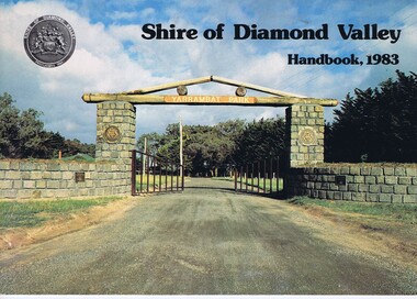 Greensborough Historical Society
Book, Shire of Diamond Valley Handbook 1983, 1983_
Guide to services provided by Shire of Diamond Valley. The Shire of Diamond Valley was a Local Government Area located about 20 kilometres northeast of Melbourne. The shire covered an area of 74.38 square kilometres and existed from 1964 until 1994.Annual guide to services in Shire of Diamond Valley32 pages, col illus., maps. Cover illustration of the bluestone gateway, main entrance to Yarrambat Park, opened 1982.shire of diamond valley, greensborough, handbooks -
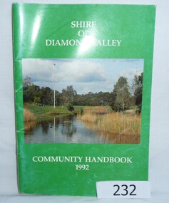 Greensborough Historical Society
Book, Shire of Diamond Valley Community Handbook 1992, 1992_
Guide to services provided by Shire of Diamond Valley. The Shire of Diamond Valley was a Local Government Area located about 20 kilometres northeast of Melbourne. The shire covered an area of 74.38 square kilometres and existed from 1964 until 1994.Annual guide to services in Shire of Diamond Valley52 pages, col illus., maps. Cover illustration of Kalparrin Gardens Greensboroughshire of diamond valley, greensborough, handbooks -
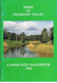 Greensborough Historical Society
Book, Shire of Diamond Valley, Shire of Diamond Valley Community Handbook 1992, 1992_
Guide to services provided by Shire of Diamond Valley. The Shire of Diamond Valley was a Local Government Area located about 20 kilometres northeast of Melbourne. The shire covered an area of 74.38 square kilometres and existed from 1964 until 1994.Annual guide to services in Shire of Diamond Valley52 pages, col illus., maps. Cover illustration of Kalparrin Gardens Greensboroughshire of diamond valley -
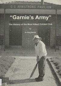 Surrey Hills Historical Society Collection
Book, Garnie's Army: the history of the Mont Albert Cricket Club, Jan-98
This is a club history of the Mont Albert Cricket Club.This is a club history of the Mont Albert Cricket Club.Presented to the S. H. Centre History by Dr. Greg McKiecricket, mont albert cricket club, garnie's army, (mr) (dr) greg mckie, sports and recreations, surrey hills golf club, north balwyn club, howard road methodist cricket teams -
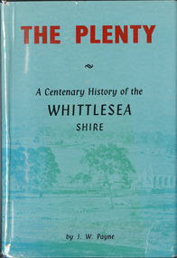 Eltham District Historical Society Inc
Book, J. W. Payne, The Plenty: A Centenary History of the Whittlesea Shire, 1975
This book traces the one hundered years of the development of the Shire of Whittlesea, from the discovery by Hume and Hovell in 1824 to the time of the centenary in 1975. The intervening years saw the settlement of Vandemonians, Sydney-siders, English, Scots, Irish and Germans, Black Thursday, the building of the Yan Yean Reservoir, the Plenty River flour millls, the timber industry, fruit-growing and export and vineyards. Personalities and pubs, subdivisions, stories of the Findon Hunt Club and various Shires including Epping. History of education and transiton from rural to urban in the south of the Shire. The work is illustrated with maps and photographs. The Shire is now the City of Whittlesea and is an immediate neighbour to the north of the Shire of Nillumbik. shire of whittlesea