Showing 404 items
matching topography
-
 Lakes Entrance Regional Historical Society (operating as Lakes Entrance History Centre & Museum)
Photograph, 1994 c
Also two photographs of U3A Geology group on track overlooking Mitchell River 04609.1 and .2 10 x 15 cm and black and white photograph of Billy Goat Bend donated by Lakes Post Newspaper 6 January 2010 04609.3 11.5 x 8.5 cmColour photograph of Mitchell River from Billy Goat Bend showing steep gorge between heavily forested high banks. Glenaladale Victoriajetties, topography, waterways -
Lakes Entrance Regional Historical Society (operating as Lakes Entrance History Centre & Museum)
Photograph, Lakes Post Newspaper, 7/05/1995 12:00:00 AM
Black and white photograph of Nick Mount of Adelaide and Michael Hook of Melbourne working on a demonstration vase at Woodsedge Gallery Lakes Entrance Victoriaarts, people, topography -
 Lakes Entrance Regional Historical Society (operating as Lakes Entrance History Centre & Museum)
Postcard, Cooper Alexander, 1900c
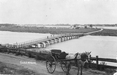
CunninghameSepia coloured postcard of first bridge over North Arm, showing view of town buildings, including Club Hotel; sand hummocks; Cunninghame Arm; die back of melaleuca on sand flats. In foreground post and rail fence beside road, two wheeled horse drawn vehicle, jinker, with grey horse standing in shafts. Ten or eleven people standing on bridge. Lakes Entrance Victoriatopography, bridges, transport -
 Lakes Entrance Regional Historical Society (operating as Lakes Entrance History Centre & Museum)
Postcard, 1888c
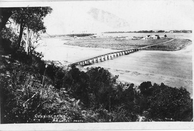
Black and white postcard of wooden bridge across the North Arm, showing sand hummocks Cunninghame Arm, Club Hotel, and die back of melaleuca on mudflats, caused by salination of Lakes after artificial entrance opened 1889. Vegetation on Kalimna Hill in foreground. Steamer on Cunninghame Arm centre top of photo. Lakes Entrance VictoriaCunninghame N Cairebridges, topography, township -
 Lakes Entrance Regional Historical Society (operating as Lakes Entrance History Centre & Museum)
Postcard, Bulmer, H D, 1940c
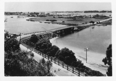
Also two black and white copies, One Colour tinted copyBlack and white photographic postcard of bridges over North Arm, showing town, electricity and telephone poles. Cunninghame Arm, sand hummocks, sand flat at entrance to town. Post and rail fence beside sealed highway. Lakes Entrance Victoriatownship, fences, topography -
 Lakes Entrance Regional Historical Society (operating as Lakes Entrance History Centre & Museum)
Photograph, Davies, Judy, 1999c
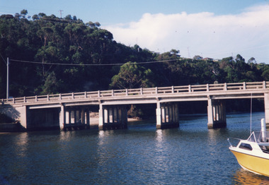
Colour photograph of the concrete bridge over the North Arm, taken from the western side, showing part of the northern embankment and four sets of piers. In the background wooded Kalimna Heights with some residences visible. Right foreground is the bow of a small runabout. Lakes Entrance Victoriabridges, boats and boating, topography -
 Lakes Entrance Regional Historical Society (operating as Lakes Entrance History Centre & Museum)
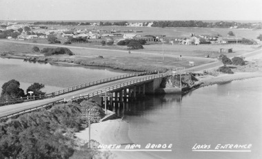
Photograph, Bulmer H D, 1945c
Notes: Club Hotel spit has not yet been formed|1 Postcard 8.5 x 13.5Black and white photograph of the North Arm Bridge, It shows the reinforced concrete bridge over the North Arm, and a rear view of other notable buildings. In the background sand hummocks. Lakes Entrance Victoriabridges, topography, township -
 Lakes Entrance Regional Historical Society (operating as Lakes Entrance History Centre & Museum)
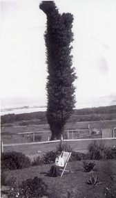
Photograph, 1920c
Black and white photograph of The Tree on Merrangbaur Hill. This dead iron bark tree covered with vine, was for many years a landmark for vessels at sea. View of sand hummocks and Cunninghame Arm in background. Lady seated on deckchair in Merrangbaur House garden, Lakes Entrance Victoria.guesthouses, topography, coast -
 Lakes Entrance Regional Historical Society (operating as Lakes Entrance History Centre & Museum)
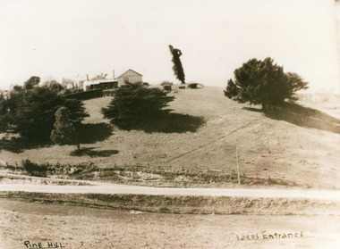
Photograph, 1950c
Also second copy which is a very clear photo.Sepia toned photograph of Pine Hill Guesthouse, showing rambling building on top of hill, landmark tree, and pine trees on hillside. Road in foreground is Princes Highway. In far distance a glimpse of Cunninghame Arm. Lakes Entrance VictoriaPine Hill Lakes Entranceguesthouses, roads and streets, topography -
 Lakes Entrance Regional Historical Society (operating as Lakes Entrance History Centre & Museum)
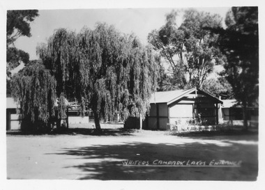
Postcard, Bulmer H D, 1945c
One of a set of eight small format postcardsSmall format black and white postcard of Whiters Camp Park, showing two cement sheet buildings, weeping willow tree and other trees. Lakes Entrance VictoriaWhiters Camp Park Lakes Entrancetourism, topography, resort -
Lakes Entrance Regional Historical Society (operating as Lakes Entrance History Centre & Museum)
Photograph, 1950 c
Also a colour photograph of western side of Red Bluff taken by Ian Fraser c 1990 number 03731.3 size 8.5 x 13.5 cmBlack and white photograph showing west side of Red Bluff with sand built up over rocky beach, low vegetation on rocky bluff, two men in swimming trunks on rocks Lake Tyers Victoriatopography, people, clothing -
Lakes Entrance Regional Historical Society (operating as Lakes Entrance History Centre & Museum)
Photograph, Lakes Post Newspaper, 1996 c
Black and white photograph of Frenchman's Gully, track to Wyanga Winery showing group of people walking towards designated pickup spot for Winery bus Lakes Entrance Victoriaaerial photograph, topography, settlement -
Lakes Entrance Regional Historical Society (operating as Lakes Entrance History Centre & Museum)
Photograph, 2000 c
Also a similar colour photograph number 03861.1 size 10 x 15 cmColour photograph of Frenchman's Gully showing Wyanga Winery vehicle on winery track with property Taradale of Leigh and Judy Davies on opposite hill Lakes Entrance Victoriaaerial photograph, topography, township -
Lakes Entrance Regional Historical Society (operating as Lakes Entrance History Centre & Museum)
Photograph, 14/04/2013 12:00:00 AM
Colour aerial photograph of Entrance at New Works showing the sand transfer building Lakes Entrance VictoriaNew Worksaerial photograph, waterways, topography -
Lakes Entrance Regional Historical Society (operating as Lakes Entrance History Centre & Museum)
Photograph, 1880 c
Colour photograph print of early painting of view from Jemmys Point towards Metung showing paddle steamer and Aboriginals in bottom left hand corner Rigby Fraser and Flannagan Islands centre of painting, The Barrier on the left Nungurner Hills on right Gippsland LakesEntrance to The Gippsland Lakesaerial photograph, township, topography -
Lakes Entrance Regional Historical Society (operating as Lakes Entrance History Centre & Museum)
Book, Land Conservation Council Victoria South Gippsland Area District 2, 1980
Report describing and assessing the natural resources of the public land in the South Gippsland (Victoria) Study Area 2, comprising the Latrobe Valley, Strzelecki Range, South Gippsland coastal plains and all of Wilson's Promontory. History, Geology, floRuth Clarkgippsland, topography, natural history, vegetation -
Lakes Entrance Regional Historical Society (operating as Lakes Entrance History Centre & Museum)
Book, Discovering the Prom. on Foot, 1986
A guide to 22 walks including four nature walks in Wilson's Promontory National Park. Includes photographic reproductions, maps and sketches to assist in identification of flora and fauna.parks, natural history, topography, vegetation -
Lakes Entrance Regional Historical Society (operating as Lakes Entrance History Centre & Museum)
Book, Garnet, J. Ros and Brooks, Ronald, Wilsons Promontory, 1970
A short history of Wilson's Promontory, Victoria, from its early settlement to proclamation as a National Park in 1908, and a short account of its management from that time to 1970. Illustrated with sketches.parks, topography, natural history, vegetation -
Lakes Entrance Regional Historical Society (operating as Lakes Entrance History Centre & Museum)
Postcard, W S Vogt Bairnsdale, 1918 c
Black and white postcard showing township, roads and rail, bridges and barked trees with cultivated land beside Tambo River Bruthen VictoriaTambo River at Bruthenjetties, waterways, topography, boats and boating -
 Lakes Entrance Regional Historical Society (operating as Lakes Entrance History Centre & Museum)
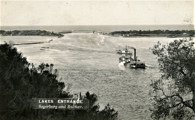
Photograph, Segerberg and Bulmer, 1910 c
Also enlargement 17 x 23 cmBlack and white photograph showing view from Jemmys Point of the entrance to the Gippsland Lakes from Bass Strait. Pioneer dredge in centre foreground, and steamer JCD. Cottages and works buildings including Rocket shed on eastern dunes, Schnapper Cottage on far right western dune. Rock groynes and tip of Bullock Island centre left. Vegetation in foreground. Lakes Entrance VictoriaLAKES ENTRANCE Segerberg and Bulmerships and shipping, topography, jetties, houses -
 Lakes Entrance Regional Historical Society (operating as Lakes Entrance History Centre & Museum)
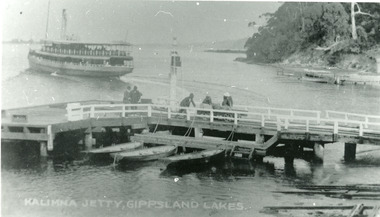
Photograph, 1920 c
Black and white photograph showing S S Gippsland leaving Kalimna Jetty heading towards Metung. View of jetty shows five men on jetty, three of them manhandling the trolley loaded with goods, probably off the Gippsland. Three small row boats tied to jetty. Two small jetties on far right and small launch. Kalimna Lakes Entrance VictoriaKalimna Jetty Gippsland Lakesjetties, navigation, ships and shipping, topography -
 Lakes Entrance Regional Historical Society (operating as Lakes Entrance History Centre & Museum)
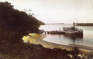
Photograph, 1925 c
Hand coloured photograph showing S S Gippsland leaving Kalimna Jetty. Small boats tied to far side of jetty, shed at left end of jetty. Jemmys Point beyond Kalimna, hummocks and the entrance in far background, point of Rigby Island on right. Kalimna beach in foreground. Lakes Entrance Victoriaships and shipping, topography, waterways, jetties -
 Lakes Entrance Regional Historical Society (operating as Lakes Entrance History Centre & Museum)
Photograph, 1908
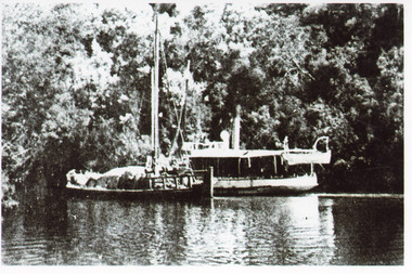
1 x Black and white photograph copied from a book 9.5 x 14.5.Black and white photograph showing S S Lady Harriet at the cliffs on the Tambo river. The Lady Harriet barge on left of S S Harriet, well vegetated cliff behind the vessels. Swan Reach Victoria1908 S S Lady Harriet at cliffs in Tambo River and her barge (on back)jetties, ships and shipping, waterways, topography -
 Lakes Entrance Regional Historical Society (operating as Lakes Entrance History Centre & Museum)
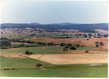
Photograph, Tambo Shire, 1994
Also second identical copyColour photograph of the Mossiface Flats, near Bruthen, shows paddocks of the rich river flats, timbered foothills in the distance, with mountain range behind. Some paddocks have been mown for grass hay. Farm buildings in foreground and background. Dam in foreground. Bruthen Victoriaanimals, agriculture, vegetation, topography -
 Lakes Entrance Regional Historical Society (operating as Lakes Entrance History Centre & Museum)
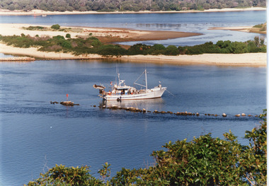
Photograph, Tambo Shire, 1990c
Second copyColour photograph of the south eastern shore of Rigby Island, Gippsland Lakes. It shows the scrub covered hummocks in the background, Hopetoun Channel, dumped sand which connects Snake Island and Rigby Islands, groynes into Narrows from Rigby Island. Fishing boat with scallop dredge moored in sheltered bay inside a groyne. Lakes Entrance Victoriaocean, waterways, topography, fishing industry -
 Lakes Entrance Regional Historical Society (operating as Lakes Entrance History Centre & Museum)
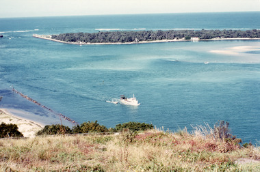
Photograph, Fraser, Ian, 1990c
Colour photograph of the lake. It shows a fishing boat with scallop dredge moving up the lake opposite the artificial entrance, grassy edge of Jemmy's Point in foreground above highway guard fence, rock groyne at entry to North Arm, sandy shallows at entry to Hopetoun Channel, scrub covered hummocks of south shore and Bass Strait in distance. Lakes Entrance Victoriaislands, waterways, topography, township -
 Lakes Entrance Regional Historical Society (operating as Lakes Entrance History Centre & Museum)
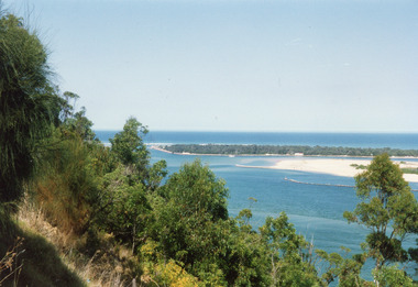
Photograph, 1992c
Colour photograph of the western side of the Entrance. It shows scrub covered hummocks, dredged sand dumped at Snake Island, rock groynes from island to lake, taken from lower side of highway at Jemmys Point. Lakes Entrance Victoriaislands, topography, waterways, township -
 Lakes Entrance Regional Historical Society (operating as Lakes Entrance History Centre & Museum)
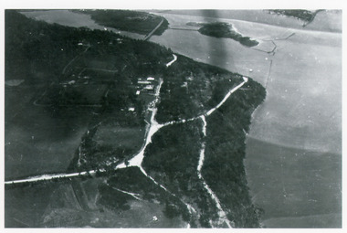
Photograph, Bulmer H D, 1940c
Black and white photograph of aerial view of Kalimna escarpment, Princes Highway, road to Kalimna Hotel, scattering of buildings including Gainsborough House, in distance is North Arm bridge, footbridge to undeveloped Bullock Island with rock groynes in place. Part of eastern pier of entrance at Lakes Entrance, Victoria.jetties, waterways, topography, township -
 Lakes Entrance Regional Historical Society (operating as Lakes Entrance History Centre & Museum)
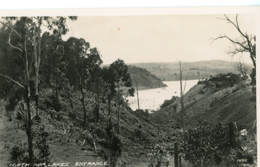
Postcard, Valentine Series, 1920c
No. 1 from Valentine Series of small postcardsBlack and white postcard showing lower reach of North Arm, and gully. Vegetation has been removed from both sides of gully. Lakes Entrance VictoriaNorth Arm Lakes Entranceislands, township, topography, waterways -
 Lakes Entrance Regional Historical Society (operating as Lakes Entrance History Centre & Museum)
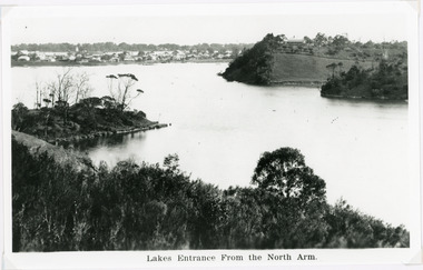
Photograph, 1940c
Black and white photograph of the township from the North Arm. It shows the calm waters between steep shorelines covered in natural vegetation and scrub. Lakes Entrance VictoriaLakes Entrance from the North Armvegetation, topography, settlement, waterways