Showing 1174 items
matching town view
-
 Glenelg Shire Council Cultural Collection
Photograph - Contact Print - Portland, 1970s
Sheets of 6 black and white contact prints from glass plate negative. Top 2, slightly different views of Old London Inn, Cr Julia and Bentinck Streets. Middle 2, slightly different views of back of bathing boxes and road, Henty Beach. Bottom 2, left image Henty Beach looking towards Fisherman's Breakwater. Right 1, image Old Town Hall.portland, julia street, portland town centre, seafront -
Glenelg Shire Council Cultural Collection
Photograph - Photograph -Bridge and Creek, n.d
Sourced from Casterton Town Hall (former Shire of Glenelg)Coloured photographs a and b. Side view of bridge with wooden railings and supports, taken from bed of creek. Banks of creek eroded. Identifying numbers 7304 a, b -
Glenelg Shire Council Cultural Collection
Negative - Negative - Portland Harbour, ZILLAH MASCHMEDT, PHOTOGRAPHER, c. 1934
NEGATIVE FOR BLACK AND WHITE PHOTOGRAPH. View from Ocean Pier, looking back to Portland. Bollard in foreground. Fisherman's Breakwater, Railway Pier, town in backgroundnegative, portland seafront, harbour, pier, deep water pier -
Glenelg Shire Council Cultural Collection
Photograph, c. 1963
Sourced from Casterton Town Hall (Former Shire of Glenelg)Black and white photo. Similar to 7273, slightly different view. -
Glenelg Shire Council Cultural Collection
Photograph - Photograph - Casterton Hospital Victoria, c. 1963
Sourced from Casterton Town Hall (former Shire of Glenelg)Black and white photo. View of entrance to Administration block, Casterton Hospital. Similar to 7193, but more distant view. -
Glenelg Shire Council Cultural Collection
Photograph - Photograph - Casterton Welfare Centre, Victoria, c. 1963
Sourced from Casterton Town Hall (Former Shire of Glenelg)Black and white photo. Same subject as 7136, slightly different view. 7136 Black and white photograph, nursing sister, Sister Moore, Mrs. Jones, sitting at a desk in the Casterton Welfare Centre -
Glenelg Shire Council Cultural Collection
Photograph - Photograph -Bridge, n.d
Sourced from Casterton Town Hall (former Shire of Glenelg)Coloured photograph. Side view of bridge, wooden rails, three wooden supports, taken from bed of creek. Banks of grass, narrow walking track along right side of creek. -
Glenelg Shire Council Cultural Collection
Photograph - Photograph - Councilor. H.D. Michell, c. 1963
Sourced from Casterton Town Hall (Former Shire of Glenelg)Black and white photo. Similar to 7281, slightly different view. 7271 Black and white photo. Cr. H.D. Michell sitting in large chair, behind desk; velvet drapes in background. Council chambers, Casterton Town Hall. -
Glenelg Shire Council Cultural Collection
Photograph - Photograph - Casterton Victoria, c. 1963
Sourced from Casterton Town Hall (former Shire of Glenelg)Black and white photo. Similar to 7271, slightly different viewBack: Black stamp '003635' -
Glenelg Shire Council Cultural Collection
Photograph, c. 1963
Sourced from Casterton Town Hall (Former Shire of Glenelg)Black and white photo. Same as 7258, 7259, slightly different viewBack: Black stamp '004144' -
Glenelg Shire Council Cultural Collection
Photograph, c. 1963
Sourced from Casterton Town Hall (former Shire of Glenelg)Black and white photo. Same subject as 7261. Slightly different view. None of the 3 councillors wearing glasses.Back: Black stamp '003635' -
Glenelg Shire Council Cultural Collection
Photograph - Photograph - Timber structure, n.d
Sourced from Casterton Town Hall (former Shire of Glenelg)Coloured photograph. Same timber structures as 7295, taken from different view. -
Glenelg Shire Council Cultural Collection
Photograph - Photograph -Shire of Glenelg Councillors, c. 1963
Sourced from Casterton Town Hall (former Shire of Glenelg)Black and white photo. Similar to 7265, 7266, slightly different view. Councillor on left hasn't got glasses on. Black and white photo. Three East Riding Councillors for Shire of Glenelg, sitting at desk, Honour Board on wall behind them with names of Past Presidents of the Shire of Glenelg 1863 -1963 Left to right T. J. Carey (in glasses), D. P. Mullane, J. P. Neylon, Council chambers, Casterton Town HallBack: Black stamp '003826'. -
Glenelg Shire Council Cultural Collection
Photograph - Photograph -Casterton Welfare Centre, Victoria, c. 1963
Sourced from Casterton Town Hall (former Shire of Glenelg)Black and white photo. Same subject as 7136, 7286, slightly different view 7136 - Black and white photograph, nursing sister, Sister Moore, Mrs. Jones, sitting at a desk in the Casterton Welfare Centre -
Glenelg Shire Council Cultural Collection
Photograph - Sheet of 12 contact prints - Various historic Portland buildings and Landmarks, c. 1970
Sheet of 12 contact prints of rephotographed photographs. Identifying numbers 5711 a, b, c, d, e, f, g, h, i, j, k, l Measurements unframed (a, d, e, g, h, k, l)5 x 3.24.6 x 3 (b, c, f, i, j) Framed (d, g, h, k)5.3 x 3.65 x 3.5 (b, c, f, i, j) (a) All Saints Catholic Church (b) 'Blainslie' (c) Railway Line and Dutton's beach, towards Whalers Bluff (d) Lighthouse, Observatory Hill (e) North side Julia Sreet, looking west, Bank of Australasia (f) Fire station, C of E grounds (g) Julia Street from Percy Street intersection looking towards sea (h) Richmond House - W.M. Learmonth (i) London Inn (j) Julia Street. Hewly and Learmonth Woolstores, Bank of Australasia (k) View from Henty Beach - Old Town Hall (l) Annie Clark's ladies school -
Glenelg Shire Council Cultural Collection
Photograph - Photograph - Battery Point, Portland, n.d
Black and white photo, view from Battery Point looking towards the town.battery point, portland, artillery, cannon, portland harbour -
Glenelg Shire Council Cultural Collection
Photograph - Photograph - Casterton, Victoria, n.d
Sourced from Casterton Town Hall (Former Shire of Glenelg)Black and white photo. View of residential area of CastertonBack: Black stamp - 003755 -
Glenelg Shire Council Cultural Collection
Photograph - Photograph - Casterton, Victoria, c. 1963
Sourced from Casterton Town Hall (Former Shire of Glenelg)Black and white photo. View of Casterton, residential areaBack: Black stamp - 003755 -
Glenelg Shire Council Cultural Collection
Photograph - Photograph - Casterton, Victoria, n.d
Sourced from Casterton Town Hall (Former Shire of Glenelg)Black and white photo. View of Casterton from elevated position. Shows street running through centre of townBack: Black stamp - 001434 -
Glenelg Shire Council Cultural Collection
Photograph, n.d
Sourced from Casterton Town Hall (Former Shire of Glenelg)Coloured photograph. Same subject as 7293, different viewBack: 'FIRE PREVENTION DAM CHETWYND' hand printed in blue biro -
Glenelg Shire Council Cultural Collection
Photograph - Photograph - Casterton, Victoria, c. 1963
Sourced from Casterton Town Hall (Former Shire of Glenelg)Black and white photo. Similar to 7278, slightly different view.Back: Black stamp ' 004144' -
Glenelg Shire Council Cultural Collection
Film - Film - Negative Portland, Zillah Maschmedt, c. 1934
Negative for black and white photo. View from Battery Point, looking across Barton's Beach to Portland. Piers, gardens, town, spire of All Saints Church -
Glenelg Shire Council Cultural Collection
Photograph - Sheet of 12 contact prints - Various historic Portland buildings and Landmarks, c. 1970
Sheet of 12 contact prints of rephotographed photographs. Measurements (a) (e)-(h) (j-i)(b) 3.7 x 55 x 3.7 Framed 5.2 x 44.5 x 4 (a) Looking south across beach at Dutton Way (b) S.S. 'Eumeralla' (c) Construction of railway pier (d) Jackass Fern Gully (e) 'Kingsley' (f) Portland Show (g) North side Julia Street looking west Bank of Australiasia (h) Henty Street looking east from Percy Street (i) Old Post Office (j) All Saints Catholic Church (k) View from Henty Street - old Town Hall (l) Opening 3rd BathsFront: (a) 'Dutton Way 1900 (b) 'S.S. Eumeralla' (c) Construction of Railway Pier (f) Portland Show (h) Henty Street, Portland (i) (B) -
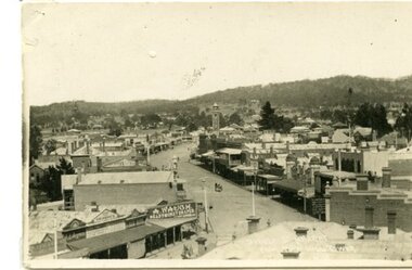 Ararat & District Historical Society (operating the Langi Morgala Museum)
Postcard
A black and white photographic postcard of a view of Barkly Street with Copes Hill in the background. Photo taken from Town Hall. Horse drawn vehicle in street scene. Shop front signs legible: A. Waugh Ready Money Draper, Albion Hotel, aganet for Brunnings, TRG Williams Photographer, E.I. Beynan, Fergusson's. -
 Kiewa Valley Historical Society
Photograph of Kiewa Valley Panorama, Kiewa Valley from No. 5 Road, Before 1945
In 1943 a camp for workmen was erected and a commencement made with the erection of plant storage and workshop buildings in the new township of Mt. Beauty. The photograph was probably taken after the completion of these buildings. There is no sign of construction of the town itself. In the latter part of 1945 work was commenced on the Mt. Beauty township area with a medical centre, general trading store and some houses under construction. The No. 5 Road, from where the photograph was taken, is the road to West Kiewa Power Station and Big Hill Scenic Lookout.Is an excellent view of the Kiewa Valley before there was little work undertaken to establish the town of Mt. Beauty. Farming was well established with the evidence of huge areas of cleared land. The junction of the East and West Kiewa Rivers can be clearly seen. The first Workmen's camp is near the river and some workshop buildings can also be seen. Black and white photograph of the Kiewa Valley, looking North.Handwritten on the back of photograph "Kiewa Valley from No. 5 Road".kiewa valley, camp, buildings, mt. beauty -
 Kiewa Valley Historical Society
Book - Non Fiction History, The Kiewa Story, circa 1993
This book provides in chronological order the development of the Kiewa Hydro-electricity scheme from the first concept (1911) to final construction work (1961). It covers the first attempt to utilise the power of the Victorian Alps water system. It started from a private syndicate and developed to the current State Electricity Commission of Victoria. The incentive for the Hydro scheme was to make money and not as an alternative to the carbon producing coal fired power plants. These coal fired power plants were increasing in numbers to service an ever increasing demand made by population expansion, especially in cities and large rural settlements. This demand spiraled up after World War II when there was a tremendous spike in immigration numbers due to refugees and displaced persons in Europe. The ability to utilise the untapped water provided by the winter snow fields, for a higher yield in electricity, was a powerful incentive to overcome the physical hardships in this remote Alpine region. Future power requirements may initiate the re-installation of the other two power stations(Pretty Valley and Big Hill) covered in original Scheme. This publication not only covers the development of the Kiewa Valley region with respect to population (within a socio-economical framework) but also the subtle but yet strong physical changes of a relatively pristine alpine region. The demands that an ever growing regional population places on the environment is clearly documented in print and black and white photographs. The working and living conditions of those who constructed and gave life to this hydro scheme is well documented in this book. It may be viewed as spartan now but was relevantly good at that moment in time, especially for those workers fleeing a devastated European environment. The successful planning and consideration to minimising any intrusion upon the natural alpine forests and high plains can viewed as an example (compared to the Tasmanian Hydro schemes) of how future hydro schemes (an inevitable requirement) will proceed. Most rural towns (in the early 1900s) were built by unencumbered rural based citizens, with the exception of Mount Beauty and Falls Creek. These two settlements were brought into life by a State (Victorian) Authority for a specific function and program. They were a gated community, that is, only open to construction workers involved with the hydro scheme. All facilities within these communities were provided by the State Electricity Commission of Victoria. The impact on the social, financial and individual independency of the community, by the transition from the S.E.C .environment to one of local government (Shire of Bright), had in some cases a severe impact.This hard covered book has a green cover with pictures on the front and back covers. The front cover has a coloured picture of a snow covered Mount Bogong taken from the opposite mountain range. The valley between both ranges has a whisk of mist over it. At the bottom of this picture are three black and white photographs covering the construction of the Kiewa Hydro - Electricity Scheme. On the back cover is a photograph, (black and white) detailing the Bogong village and Junction dam containing lake Guy. The inside front cover is a black and white photograph which details the construction of the West Kiewa tailrace tunnel during April 1951. The inside back cover is a black and white photograph of the concrete pour at the Clover Dam circa 1952. All photographs and sketches are in black and white. The pages are approximately 160 g/m2 and those which have photographs are on gloss paper.Book spine: "The Kiewa Story Graham Napier Geoff Easdown" alongside this is a white framed circle with white spokes radiating out and underneath in white lettering SECkiewa valley, hydro scheme, victorian alpine region, electricity generators, graham napier, geoff easdown -
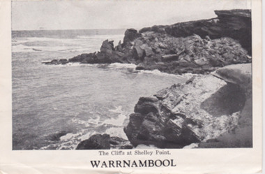 Warrnambool and District Historical Society Inc.
Postcard - Strip Card photos of Warrnambool, Mid 20th century
These types of folding postcards, showing scenes and buildings in Australian towns, were mass produced for tourists in the 1930s, 40s and 50s and later. Many similar cards of Warrnambool views have survived today. These commercial photographs are of minor interest as there are many other copies available. They show what tourists were buying 60 or 70 years ago and give us some idea of what Warrnambool streets and tourist spots looked like at that time. This is a series of 15 black and white postcards of views of Warrnambool folded into a packet originally designed to be sent by mail but the cover is missing. The photographs have a white background. The word ‘Warrnambool’ is on the front card. Each card has a title eg. ‘The Cliffs at Shelley Point’, ‘Hopkins Falls’. warrnambool, tourism -
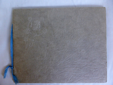 Warrnambool and District Historical Society Inc.
Album - Views of Warrnambool
The album contains postcards (photographs). The photographs (postcards) of Warrnambool and district in the 1930s/40s include views of the Botanic Gardens, the coast line, the main streets, the War Memorial and Hopkins Falls. The postcards from the 1890s include Wilmot, the Hopkins River, Hopkins Falls and Shelly Beach.The postcards in the album are in good condition and will be useful for reproduction. The 1930s/40s collection of photographs (also postcards) is a useful one also and a good example of how people preserved mementoes of their visit to a town. All the photographs are contained in other collections or albums held elsewhere in the Historical Society collection.This is a photograph album of ten pages with a buff-coloured cover of thickened card with a raised surface and an embossed image of a woman in the left corner of the front page. There are five postcards attached to the inside covers and 31 other photographs (postcards) in the slots provided. One photograph is missing from these slots. Embossed ornately decorated image of a woman on the front cover. postcards and photographs, warrnambool 1930s/1940s -
 Eltham District Historical Society Inc
Photograph, View at Eltham, Vic, c.1924
Copy of possible Rose Stereograph Co. postcard “View at Eltham, Vic.”, c.1924 looking southwest from Main Road near York Street to Bridge Street and the original 1875 bridge across what is now the Alistair Knox Park The land in the foreground was first bought from the Crown by J.M. Holloway in 1851. The land was sub-divided and called "Little Eltham". Bridge Street was created as part of the sub-division. Most of the sub-division was residential lots but the creek valley was divided into lots for small farms. Council started to buy the land for the Eltham Town park in the early 1960s. The area was used as a garbage tip and filled above the flood plain of the creek. Development of the land for a park began in the early 1970s. The house on the right was owned for many years by the Hill family until Council bought it in the early 1960s. The house was built in the 1850s or 60s. The house on the left stood on what is now the southwest corner of Susan and Bridge Streets. The Braithwaite family was associated with this house. The double line of fencing in the foreground was a continuation of York Street to the creek. The Bridge Street bridge was built in 1875 and replaced in 1958. (Ref: Early view of Little Eltham; Byways of History by Colleen Ison, Publication unk, 24 August 1982) Reproduced on p61 of 'Pioneers & Painters' Date estimated on same as View at Hurstbridge featuring Wattle Valley EstateThis photo forms part of a collection of photographs gathered by the Shire of Eltham for their centenary project book,"Pioneers and Painters: 100 years of the Shire of Eltham" by Alan Marshall (1971). The collection of over 500 images is held in partnership between Eltham District Historical Society and Yarra Plenty Regional Library (Eltham Library) and is now formally known as the 'The Shire of Eltham Pioneers Photograph Collection.' It is significant in being the first community sourced collection representing the places and people of the Shire's first one hundred years.Digital image 120 format B&W negative Prints 17 x 25 cm and 10 x 15 cmsepp, shire of eltham pioneers photograph collection, eltham, bridge street, bridge, alistair knox park, braithwaite, bridge street bridge, eltham town park, hill family home, main road, pioneers and painters, york street -
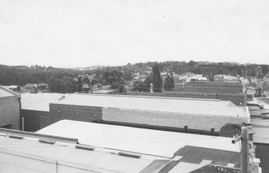 Ringwood and District Historical Society
Photograph, View from Ringwood Town Hall Roof looking East (2 views). 1962
... View from Ringwood Town Hall Roof looking East (2 views.... (2 copies) View from Ringwood Town Hall Roof looking East (2 ...Catalogue card reads, "Picture taken from town hall roof. 1962". Looking towards East Ringwood. (2 copies)