Showing 2422 items
matching townships
-
 Bendigo Historical Society Inc.
Map - ELMORE, 7/08/1911
Map: Township of Elmore, Parish of Elmore, County of Bendigo ( number 159 in Map Cupboard 1)map, bendigo, township, elmore, county of bendigo -
Bendigo Historical Society Inc.
Map - GOORNONG, 1/10/1906
Map: Township of Goornong, Parish of Goornong, County of Bendigo ( number 154 in Map Cupboard 1)map, bendigo, township, goornong, county of bendigo -
Bendigo Historical Society Inc.
Map - HUNTLY, 7/01/1904
Map: Township of Huntly, Parish of Huntly, County of Bendigo ( number 150 in Map Cupboard 1)map, bendigo, township, huntly, parish of huntly, county of bendigo -
Bendigo Historical Society Inc.
Map - TOWNSHIP OF HEATHCOTE SHEET 2, Circa 1935
Map: Township of Heathcote sheet 2. Parish plan (number 254 in map cupboard 1)map, dalhousie, township, heathcote -
 Clunes Museum
Photograph
SEPIA PHOTOGRAPH OF CLUNES TOWNSHIP - showing Camp Hill and the Commercial Hotel. Mt Beckworth in distance. local history, photography, photographs, clunes township -
 Otway Districts Historical Society
Photograph, Knox Collection, Beech Forest township, c.1903, c.1903
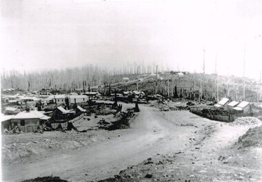
J.W. Gardner erected premises in Beech Forest which formed the core of a village. No further progress was made until access was facilitated though the development of a narrow gauge railway approved by the Victorian Parliament in 1898. Construction commenced in 1900. From this time Colac and Geelong business interests began investment in Beech Forest and established various retail and service establishments over the next few years. In 1902 three early settlers, Gardner, Charles Buchanan and John Cockerill, divided part of their land or bought land which was sold to businesses. On these subdivisions were created saleyards, general stores, a post office, bakery, blacksmithing, banks, a police station and lock-up, a public hall, churches, a state school, bootmaker, butcher, solicitor's office, hairdresser, billiard's saloon and newsagency.B/W. 188mm x 266mm. A general view of Beech Forest township in c.1903.beech forest; township; -
 Bendigo Historical Society Inc.
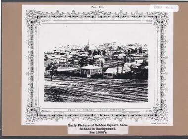
Document - GOLDEN SQUARE P.S. LAUREL ST. 1189 COLLECTION: PHOTO, 1900's
Copy of N.J. Caire print 'View of Golden Square township' mounted on light brown board.N.J. Caire, Photo Sandhurst. Forbes & Halmes, Agents.education, primary, golden square laurel st p.s., golden square township. -
 Kew Historical Society Inc
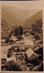
Postcard - Walhalla, 1920-25
Henry Christian (c.1809-91) was one of the first settlers in Kew. He arrived in Victoria with his wife Agnes and son Orlando in 1855 on the Gypsy Queen. He established a rope-making business in Bulleen Road by 1858 but was declared insolvent two years later. In his final years, he was celebrated as one of the oldest living settlers of the district. His son, Orlando Henry Beater Christian (c.1853-1930) became a member of the Hawthorn Band and a foundation member of the Willsmere Swimming Club. Orlando and his wife Elizabeth had four children: Henry Beater (1886-1962), Ada Susannah May (1888-1962), Orlando Julius (1891-1917) and Lilian Adelaide ( -1956).An item from an outstanding and diverse photographic collection, assembled by members of the Christian family of Pakington Street, Kew, comprising professional and amateur photography, depicting individuals, natural and settled environments and the interactions between these worlds. Many of the photographs vividly capture the worlds of three generations of men - Henry Christian, his son Orlando Henry Beater Christian, and his grandson of Henry Christian. The most important photographer was the youngest, Henry Christian, who was a keen explorer, not just of his immediate environment but also of the Victorian wilderness. His major opus is contained in two albums in which he records, sometimes in majestic detail and on other occasions the intimate features of the natural world. His photographic travels during the 1920s, often in solitary ramblings but on other occasions with companions, recall the heroic landscape photography of an earlier era, pioneered by Nicholas Caire. In addition to their aesthetic value, the albums are historically significant records within the State of Victoria, of what is now a distant point in time, and of places that have become radically altered through human intervention.Small sepia Kodak postcard of the Township of Walhalla, probably taken by the Kew photographer, Henry Christian. henry christian (1886-1962), landscape photography, walhalla -- victoria, christian-washfold collection -
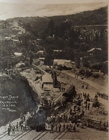 Kew Historical Society Inc
Postcard, M. Lee, First Train to Walhalla 15.3.1910, 1910
One of a number of 'real photo' and commercial postcards created by or owned by members of the Christian and Washfold families of Kew. The postcards are part of a larger collection of photographs, postcards and publications donated to the collection in May 2021.Small black and white postcard of the first train to Walhalla arriving in the township on 15 March 1910.First Train to Walhalla 15.3.1910. M. Lee Photohenry christian (1886-1962), landscape photography, trains -- walhalla -- victoria, christian-washfold collection -
 Sunbury Family History and Heritage Society Inc.
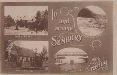
Post Card, In and around Sunbury with Greeting
The post card is one of a set that were produced by Chris Christainsen, who had a pharmacy in Sunbury and was also a photographer. The four photos featured on the card are the Rupertswood Mansion, St Mary's Church of England, Jacksons Creek in floods ands Sunbury Railway station.The buildings and places featured on the card are of historical significance in the Sunbury town precinct. A post card with four sepia photographs of interesting sites which can be seen in the Sunbury township. IN AND AROUND SUNBURY WITH GREETING. christainsen, chris., rupertswood mansion, st. mary's church of england., jacksons creek, sunbury railway station -
 Lakes Entrance Regional Historical Society (operating as Lakes Entrance History Centre & Museum)
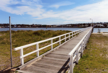
Photograph - Footbridge, 2008
Date made August 2008|This is the paired after photograph used in the 150 year Lakes Entrance 1858 - 2008 display.Colour photograph of the footbridge crossing Cunninghame Arm waterway, the township is in the foreground, Lakes Entrance, Victoria.bridges, waterways, township -
Tatura Irrigation & Wartime Camps Museum
Book, No Parallel
... townships ...Partially funded by Australian Bicentennial Authority to celebrate Australian Bicentenary, 1988. Deals with development of the region over the century.Green, illustrated dust cover, relating to early days. Printing in yellow. Plain green hard covercommunity formation, townships, 1914-18 war -
Lakes Entrance Regional Historical Society (operating as Lakes Entrance History Centre & Museum)
Album
... Townships ...Twenty six images c 20 x 25 cm purchased from Apple Lea Craft ShopWhite covered album containing images of early East Gippsland Victoriawaterways, islands, townships -
 Ringwood and District Historical Society
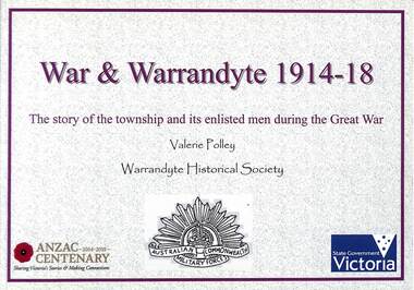
Book, Valerie Polley, War & Warrandyte 1914-18 - Valerie Polley, 2016
The story of the township and its enlisted men during the Great War, by Valerie Polley, Warrandyte Historical Society.This book has been compiled from posters exhibited in the Warrandyte Historical Society's exhibition entitled War & Warrandyte 1914-18, made possible by a grant through the Anzac Centenary Community Grants (Veterans Fund) from the Victorian Government and the Victorian Veterans Council. -
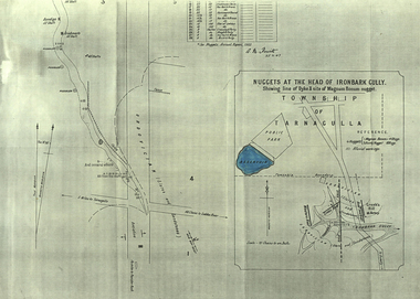 Federation University Historical Collection
Plan, A.M. Howitt, Nuggets at the Head of Ironbark Gully, Tarnagulla, c1907
Plan showing part of the township of Tarnagulla, and the Ironbark Gully area including Western Reef and Creek's Hill.tarnagulla, ironbark gully, western reef, creek's hill, cgt -
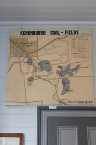 Coal Creek Community Park & Museum
Map of Korumburra's Coal, Korumburra Coal Fields, 1910
8513.1 - Map of coal fields, township, roads, creeks, railways and boreholes in the Korumburra area. Painted on Canvas -
Bendigo Historical Society Inc.
Map - KANGAROO FLAT, 27/.01/1932
Map: Township of Kangaroo Flat, Parish of Sandhurst, County of Bendigo ( number 148 in Map Cupboard 1)map, bendigo, township, kangaroo flat, parish of sandhurst, county of bendigo -
Bendigo Historical Society Inc.
Map - KOOYOORA, July 23rd 1857
Map: The Township of Kooyoora and suburban allotments in the Parish of Kingower. This plan has been applied to a newer backingmap, township, kooyoora, allotments, parish of kingower -
Bendigo Historical Society Inc.
Map - HARCOURT, No date visible
Map: Township of Harcourt, Parish pf Harcourt, County of Talbot, (number 265 in map cupboard 1)map, talbot, township, harcourt -
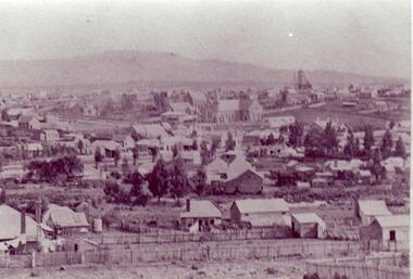 Clunes Museum
Photograph
BLACK AND WHITE PHOTOGRAPH OF CLUNES TOWNSHIP, TAKEN FROM LESLIE STREET EAST, OFF SMEATON ROAD.METHODIST & PRESBYTERIAN CHURCHES IN CENTRE TAKEN FROM LESLIE ST. EAST OF SMEATON ROAD NOTE WESLEYAN CHURCH HAS SPIRElocal history, photography, photographs, clunes township -
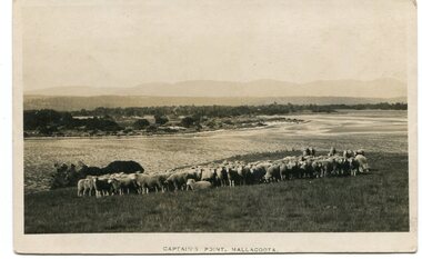 Orbost & District Historical Society
black and white photograph, first half 20th century
This photograph is of Captain's Point, Mallacoota.This is a pictorial record of Mallacoota in the first half of the 20th century. It shows the young township.A small black / white photograph / of a flock of sheep on a hilltop with the ocean behind them. A township can be seen in the background.on front - " Captain's Point Mallacoota"mallacoota-captains-point -
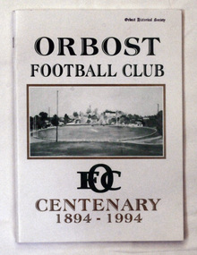 Orbost & District Historical Society
book, Orbost Football Club Centenary 1894 - 1994, 1994
This book was made for celebration of the centenary of the Orbost Football Club in 1994. The Orbost football club players were known as the Busters and wore green and gold guernseys. An Orbost football team has participated in the East Gippsland League since the early 20th century. In 2003 in response to a dwindling population, the Snowy Rovers and Orbost Football Clubs were driven to merge into the Orbost Snowy Rovers.Orbost Football Club through its many changes has always been an important social fabric of the Orbost community. Sport is often regarded as an important part of life in rural Australia, contributing to community identity, sense of place, social interaction and good health.A soft covered book of white with large green and gold print on the cover. There is a photograph of a football ovel with a township behind it.orbost-football-club-centenary recreation sport football -
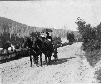 Upper Yarra Museum
Negative Photographic Reproduction, Mrs Booth drives her buggy through Warburton township
Mrs Booth drives her buggy through Warburton township Negative Black white Scanned at 600 dpimrs booth driving buggy warburton township -
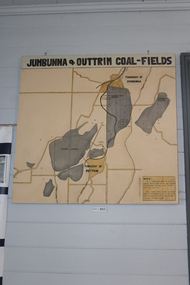 Coal Creek Community Park & Museum
Jumbunna Coal Field Map, Jumbunna and Outtrim Coal Fields, 1910
8512.1 - Map of coal fields, Township, roads rail lines and creeks in the Jumbunna and Outtrim areas. Painted on canvas. -
Port Melbourne Historical & Preservation Society
Plan - Township of Sandridge, 1855
COPYRIGHT PUBLIC RECORDS OFFICE Plan of the Township of Sandrdge 1855 - copy from Public Record Office 1978local government - municipal district of sandridge, town planning, j jones -
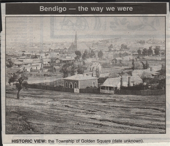 Bendigo Historical Society Inc.
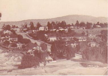
Newspaper - JENNY FOLEY COLLECTION: HISTORIC VIEW
Bendigo Advertiser ''The way we were'' from 1999. Historic view: the township of Golden Square, date unknown.newspaper, bendigo advertiser, the way we were -
Bendigo Historical Society Inc.
Map - JANIEMBER EAST, 12/09/1876
Map: Two maps applied to the one backing, Township of Janiember East. Additional allotments, Townshihp of Janiember Eastmap, bendigo, janiember east, allotments janiember east, serpentine -
Bendigo Historical Society Inc.
Map - PLAN OF THE TOWNSHIP OF SANDHURST(PHOTOCOPY)
Map: Photocopy of a plan of the Township of Sandhurst. Dated 26 July 1854 ( number 141 in Map Cupboard 1)map, bendigo, city streets, township of sandhurst, early bendigo, city streets -
Bendigo Historical Society Inc.
Map - RAYWOOD, 18/09/1930
Map: Township of Raywood, Parish of Neilborough,County of Bendigo. Parish plan (number 270 in map cupboard 1)map, bendigo, township, raywood -
Bendigo Historical Society Inc.
Map - RAVENSWOOD, April 6th 1872
Map: Township of Ravenswood. Parish plan, has a 1913 calendar as a backing (number 266 in map cupboard 1)map, bendigo, township, ravenswood