Showing 576 items matching "yarra yarra district"
-
 Marysville & District Historical Society
Photograph (item) - Colour photograph, 06-12-2008
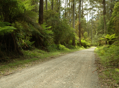
A digital copy of a colour photograph of Lady Talbot Drive in Marysville in Victoria.A digital copy of a colour photograph of Lady Talbot Drive in Marysville in Victoria. Lady Talbot Drive a 24 kilometer scenic rainforest car journey which passes a number of walks and waterfalls in the Yarra Ranges National Park. Lady Talbot Drive is named after Lady Sarah Elizabeth, the wife of Sir Reginald Talbot, who was the Governor of Victoria from 25th April, 1904 to 6th July 1908.lady talbot drive, lady talbot forest drive, marysville, victoria, sir reginald talbot, lady sarah elizabeth talbot -
 Marysville & District Historical Society
Photograph (item) - Colour photograph, 20-09-2008
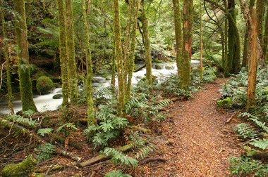
A colour photograph of the Beeches Rainforest Walking Track near Marysville in Victoria.A colour photograph of the Beeches Rainforest Walking Track near Marysville in Victoria. Starting from the spectacular Taggerty Cascades, the Beeches Rainforest Walk meanders through the ancient cool temperate rainforest of the Yarra Ranges. Dominated by Myrtle Beech trees and stands of Mountain Ash, it is home to the lyrebird which live on the forest floor.beeches rainforest walking track, marysville, victoria, taggerty river, taggerty cascades, yarra ranges, myrtle beech, mountain ash, lyrebird -
 Marysville & District Historical Society
Photograph (item) - Colour photograph, 20-09-2008
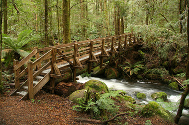
A colour photograph of a wooden bridge over the Taggerty River that is part of the Beeches Rainforest Walk near Marysville in Victoria.A colour photograph of the Beeches Rainforest Walking Track near Marysville in Victoria. Starting from the spectacular Taggerty Cascades, the Beeches Rainforest Walk meanders through the ancient cool temperate rainforest of the Yarra Ranges. Dominated by Myrtle Beech trees and stands of Mountain Ash, it is home to the lyrebird which live on the forest floor.beeches rainforest walking track, marysville, victoria, taggerty river, taggerty cascades, yarra ranges, myrtle beech, mountain ash, lyrebird -
 Marysville & District Historical Society
Document (item) - Word Document, Rene de Koning, Lady Talbot Drive Named After Sir Reginald Arthur James Talbot (1841 - 1929), 12-05-2022
An account of the life of Sir Reginald Talbot and his wife Lady Sarah Elizabeth, whom Lady Talbot Drive is named after.An account of the life of Sir Reginald Talbot and his wife Lady Sarah Elizabeth, whom Lady Talbot Drive is named after. Lady Talbot Drive a 24 kilometer scenic rainforest car journey which passes a number of walks and waterfalls in the Yarra Ranges National Park.lady talbot drive, lady talbot forest drive, sir reginald talbot, lady sarah elizabeth talbot, marysville, victoria -
Marysville & District Historical Society
Flyer (item) - Information Flyer, Artworkz Tourism, Marysville-Phantom Falls, Post 2009
A flyer that was produced as a guide to Phantom Falls near Marysville in Victoria.A flyer that was produced as a guide to Phantom Falls near Marysville in Victoria. Phantom Falls is located off Lady Talbot Drive. Lady Talbot Drive a 24 kilometer scenic rainforest car journey which passes a number of walks and waterfalls in the Yarra Ranges National Park. Lady Talbot Drive is named after Lady Sarah Elizabeth, the wife of Sir Reginald Talbot, who was the Governor of Victoria from 25th April, 1904 to 6th July 1908.phantom falls, marysville, victoria, lady talbot drive, lady talbot forest drive, sir reginald talbot, lady sarah elizabeth talbot, yarra ranges national park -
 Marysville & District Historical Society
Photograph (Item) - Colour photograph, 05-1985
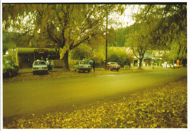
A colour photograph of Murchison Street in Marysville in Victoria.A colour photograph of Murchison Street in Marysville in Victoria.OLD YARRA TRACK SHOPPE/ MARYSVILLE - MAY 1985murchison street, marysville, victoria, old yarra track shoppe -
 Marysville & District Historical Society
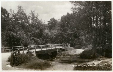
Postcard (item) - Black and white postcard, Valentine Publishing Co. Pty. Ltd, The Old Ford, Marysville No.9, 1923-1963
An early black and white photograph of the old ford in Marysville, Victoria.An early photograph of the bridge at the end of the main street in Marysville which is near the Buxton-Marysville Road and the Marysville-Wood's Point Road intersection. The Marysville-Buxton Road joins the Maroondah Highway which leads to Alexandra. The Marysville-Woods Point Road was originally part of the Yarra Track, constructed in the early 1860s to provide access between Healesville and the Woods Point Goldfields. Despite the steep terrain and engineering difficulties, the Yarra Track soon became a busy route used by pack horses, horse-drawn drays, and wagons. Today this sealed mountain road is a popular scenic drive between Marysville and Warburton. This photograph was published by the Valentine Publishing Co Pty. Ltd as a souvenir of Marysville.marysville, victoria, valentine publishing co, souvenir, buxton-marysville road, marysville-wood's point road, maroondah highway, alexandra, yarra track, mining -
 Marysville & District Historical Society
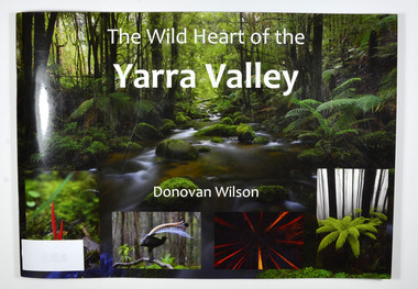
Book, The Wild Heart of the Yarra Valley
A pictorial book of the flora, fauna, rivers, waterfalls and rainforest in the Upper Yarra ValleyPaperback. Front cover has a main photograph of a creek running through a forest. There is also four smaller photographs. They are of a Red Coral Fungi, a Superb Lyrebird, a night time view looking upwards in a grove of trees and a view of a Soft tree fern. The back cover has a photograph of a Superb Lyrebird.yarra valley, upper yarra valley, flora, fauna, photography, rivers, waterfalls, rainforest, nature, donovan wilson -
 Marysville & District Historical Society
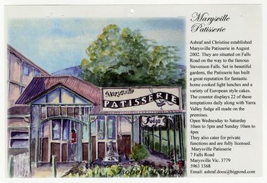
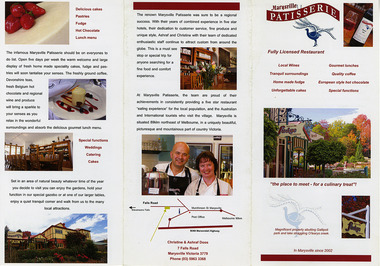
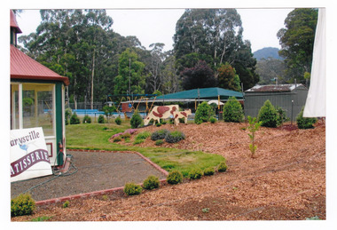
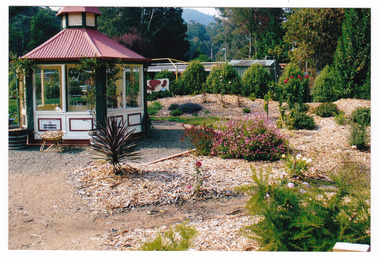
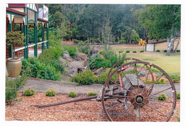
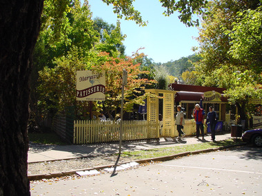
Ephemera (Item) - Calendar page, Isobel Gregory, Marysville Patisserie, Unknown
A page from a calendar showing the Marysville Patisserie in Marysville in Victoria.A page from a calendar showing the Marysville Patisserie in Marysville in Victoria. The Marysville Patisserie was established in Falls Road in 2002. The Patisserie was known for its delicious light lunches, European-style cakes, and Yarra Valley fudge, all of which were made on the premises. The Patisserie, along with most of the businesses in Marysville, was destroyed in the 2009 Black Saturday bushfires.marysville patisserie, marysville, victoria, isobel gregory, 2009 black saturday bushfires -
 Marysville & District Historical Society
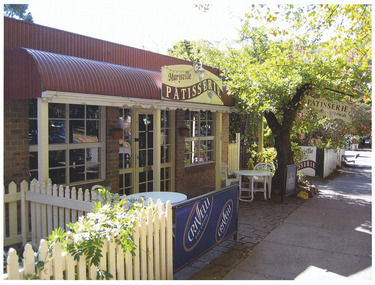
Photograph (Item) - Colour photograph, Unknown
A colour photograph of the Marysville Patisserie in Marysville in Victoria.A colour photograph of the Marysville Patisserie in Marysville in Victoria. The Marysville Patisserie was established in Falls Road in 2002. The Patisserie was known for its delicious light lunches, European-style cakes, and Yarra Valley fudge, all of which were made on the premises. The Patisserie, along with most of the businesses in Marysville, was destroyed in the 2009 Black Saturday bushfires.marysville patisserie, marysville, victoria, 2009 black saturday bushfires -
 Marysville & District Historical Society
Ephemera (Item) - Advertising brochure, Marysville Patisserie, Unknown
An advertising brochure for the Marysville Patisserie in Marysville in Victoria.An advertising brochure for the Marysville Patisserie in Marysville in Victoria. The Marysville Patisserie was established in Falls Road in 2002. The Patisserie was known for its delicious light lunches, European-style cakes, and Yarra Valley fudge, all of which were made on the premises. The Patisserie, along with most of the businesses in Marysville, was destroyed in the 2009 Black Saturday bushfires.marysville patisserie, marysville, victoria, 2009 black saturday bushfires -
 Marysville & District Historical Society
Photograph (Item) - Colour photograph, Unknown
A colour photograph of the Marysville Patisserie in Marysville in Victoria.A colour photograph of the Marysville Patisserie in Marysville in Victoria. The Marysville Patisserie was established in Falls Road in 2002. The Patisserie was known for its delicious light lunches, European-style cakes, and Yarra Valley fudge, all of which were made on the premises. The Patisserie, along with most of the businesses in Marysville, was destroyed in the 2009 Black Saturday bushfires.MARYSVILLE/ PATISSERIEmarysville patisserie, marysville, victoria, 2009 black saturday bushfires -
 Marysville & District Historical Society
Photograph (Item) - Colour photograph, 17-01-2007
A colour photograph of the Marysville Patisserie in Marysville in Victoria.A colour photograph of the Marysville Patisserie in Marysville in Victoria. The Marysville Patisserie was established in Falls Road in 2002. The Patisserie was known for its delicious light lunches, European-style cakes, and Yarra Valley fudge, all of which were made on the premises. The Patisserie, along with most of the businesses in Marysville, was destroyed in the 2009 Black Saturday bushfires.132 17 JAN 2007marysville patisserie, marysville, victoria, 2009 black saturday bushfires -
 Marysville & District Historical Society
Photograph (Item) - Colour photograph, Unknown
A colour photograph of the Marysville Patisserie in Marysville in Victoria.A colour photograph of the Marysville Patisserie in Marysville in Victoria. The Marysville Patisserie was established in Falls Road in 2002. The Patisserie was known for its delicious light lunches, European-style cakes, and Yarra Valley fudge, all of which were made on the premises. The Patisserie, along with most of the businesses in Marysville, was destroyed in the 2009 Black Saturday bushfires.MARYSVILLE/ PATISSERIE/ ROTUNDAmarysville patisserie, marysville, victoria, 2009 black saturday bushfires -
 Marysville & District Historical Society
Photograph (Item) - Colour photograph, 17-01-2007
A colour photograph of the Marysville Patisserie in Marysville in Victoria.A colour photograph of the Marysville Patisserie in Marysville in Victoria. The Marysville Patisserie was established in Falls Road in 2002. The Patisserie was known for its delicious light lunches, European-style cakes, and Yarra Valley fudge, all of which were made on the premises. The Patisserie, along with most of the businesses in Marysville, was destroyed in the 2009 Black Saturday bushfires.marysville patisserie, marysville, victoria, 2009 black saturday bushfires -
 Marysville & District Historical Society
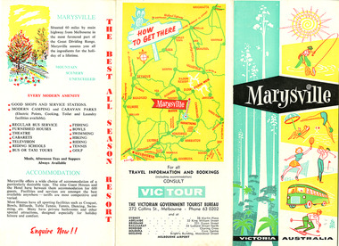
Ephemera (Item) - Tourist brochure, Victorian Government Tourist Bureau, Marysville Victoria Australia, Unknown
A tourist brochure on Marysville and the surrounding area published by the Victorian Government Tourist Bureau for the Marysville Tourist and Progress Association.A tourist brochure on Marysville and the surrounding area published by the Victorian Government Tourist Bureau for the Marysville Tourist and Progress Association.marysville, victoria, tourist brochure, victorian government tourist bureau, cumberland valley, cumberland falls, cora-lyn falls, robart's lookout, meeting of the waters, warburton, acheron way, healesville, launching place, reefton spur, upper yarra dam, maroondah highway, black spur, maroondah dam, alexandra, mansfield, jamieson, wood's point, eildon weir, snob's creek, rubicon, lake mountain, marysville tourist and progress association, the cumberland, kerami guest house, kooringa guest house, marylands guest house, marylyn guesthouse, marysville hotel, mount kitchener house, barton brothers' store, fruit salad farm, marysville dairy, marysville caravan park, marysville garage, marysville riding school, marysville theatre, mckenzie's tourist services, potters fruit and milk bar, arosa holiday cottages, scenic motel, beauty spot walk, red hill walk, wishing well, taggerty river, mount gordon, steavenson falls, keppel's lookout, keppel's falls -
 Marysville & District Historical Society
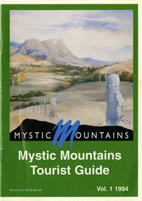
Ephemera (Item) - Tourist Guide, Michael Nash et al, Mystic Mountains Tourist Guide Vol. 1 1994, 1994
A tourist guide outlining services, accommodation, activities and places of interest to visit in and around Marysville and the local district.A tourist guide outlining services, accommodation, activities and places of interest to visit in and around Marysville and the local district.ACKNOWLEDGEMENTS:/ Marysville and District Tourist and Progress Association, Marysville/ Office of the Department of Conservation & Natural Resources, Shire/ of Alexandra Visitors Guide and all our advertisers whom without/ their support this publication would not have been possible.marysville, victoria, australia, tourist guide, mystic mountains, michael nash, dudley jones, marysville and district tourist and progress association, department of conservation & natural resources, shire of alexandra, paperwork professionals, pp art services, harrier printing, darrowby deer farm, heidi boesch, hidden talent craft gallery, olde yarra track shoppe, lady talbot forest drive, mathilde's of marysville country guest house, wishing well, taggerty river picnic area, taggery river, phantom falls, keppel falls, the beeches walking track, mount sugarloaf, beauty spot walk, tree fern gully walk, michaeldene track, keppel track, woods lookout track, marysville caravan park, baree mud brick cottages, cumberland scenic reserve, nanda binya lodge, cambarville, the big tree, barton's lookout, cumberland falls, our lady of the snows catholic church, anglican church christ, marysville christian fellowship, sovereign view, the big culvert, st fillan, steavenson's restaurant, the birches resort, cathedral range state park, tower motel, marysville post shop, lake mountain, wirreanda festival, cross country ski hire, marysville hotel motel, kerami house, marysville holiday cottages, missing links miniature golf, top shop pancake parlour, marylands guest house, dalrymples guest cottages, crossways country inn, esa camping & conference centre, scenic motel, the cumberland, maryton park holiday cottages, lomatia lodge holiday house, willowbank gallery and art centre, igloo roadhouse, a model tours, geoffrey pope & associates -
 Marysville & District Historical Society
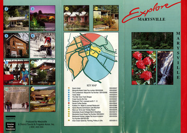
Ephemera (Item) - Information brochure, Marysville and District Tourist and Progress Association, Explore MARYSVILLE, Unknown
An information brochure with photographs and locations of various accommodation sites and businesses in Marysville as well as activities to experience in and around Marysville. This brochure was produced by the Marysville & District Tourist & Progress Association with the support of the Victorian Tourism Commission.An information brochure with photographs and locations of various accommodation sites and businesses in Marysville as well as activities to experience in and around Marysville.Supported by/ Victorian/ Tourism/ Commission Produced by Marysville/ & District Tourist & Progress Assoc. Inc.marysville, victoria, australia, information brochure, scenic motel, marysville motel hotel, the cumberland, tower motel, the olde yarra track shoppe, cross country ski hire, restaurant tirol, danish coffee garden, kufstein inn, lake mountain, mary-lyn resort, dalrymples guest cottages, marylands guest house, blackwood holiday lodges, abor green galleries, marysville & district tourist & progress association, victorian tourism commission -
 Marysville & District Historical Society
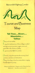
Map (Item) - Tourist and business map, Narbethong Community and Tourism Group, Narbethong Buxton Taggerty Tourist and Business Map, 04-2008
A tourist and business map of Narbethong, Buxton and Taggerty. This map was produced by the Narbethong Community and Tourism Group in April 2008. It was produced to promote the natural attractions, adventure activities and food trail from the Black Spur, through Narbethong, Buxton and Taggerty.A tourist and business map of Narbethong, Buxton and Taggerty.This publication has been produced by the Narbethong Community and Tourism/ Group (NCTG) to promote the natural attractions, adventure activities and food/ trail from the Black Spur, through Narbethong, Buxton and Taggerty./ the information provided in this publication has been supplied by the individual/ members. NCTG takes no responsibility for its accuracy./ April 2008narbethong, buxton, taggerty, victoria, australia, tourist and business map, narbethong community and tourism group, acheron valley, yarra track, wood's point, black spur, mystic mountains, the meeting of the waters, cathedral range, danico design counted cross stitch, things of sand & stone, buxton zoo nursery & oddz & enz, willowbank at taggerty, safe trek 4wd services, pnl 4wdriving, buxton trout and salmon farm, mystic mountains ski hire & outdoors, narbethong ski hire, highwood health centre, cathedral view natural therapies, narby cabinets, plants by shelian, gb timber, executive signs, rb automotive repairs, buxton car care, marysville towing & equipment hire, martyn slade building design, cathedral peak framing, black spur roadhouse & ski hire, tudor lodge roadhouse & ski hire, buxton roadhouse & persian bazzar, buxton post office general store & niche bar, igloo roadhouse, taggerty store, narby eggs, marapana agistment park, mantirri blueberry farm, carmyle farm, hazelwood hazelnuts, south cathedral lavender farm, cathedral cherries, black spur motel & caravan park, woodlands rainforest retreat, chestnut glade, black spur inn, wombat cottage, abbey lake luxury b & b spa cottages, blue views holiday cottages, camp narbethong, marapana farm stay b & b, mantirri blueberry farm b & b, little dene garden cottages, silverstream b & b cottages, nareen cabins, moondai farm b & b, south cathedral farm luxury b & b cottages, yarrolyn caravan park, sarsens rest, lomah retreat, pinjarra gardens, kingbilli country estate, henry viii manor house, buxton hotel, butters cafe of buxton, wagtail wines, little river wines, lanterns at willowbank, wirrawilla rainforest walk, wilhemina falls, the cascades -
 Marysville & District Historical Society
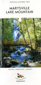
Map (Item) - Tourist map, Mystic Mountains Tourism, OFFICIAL VISITORS' MAP MARYSVILLE LAKE MOUNTAIN, Unknown
A visitors' map of Marysville and Lake Mountain produced by Mystic Mountains Tourism for Visit Victoria.A visitors' map of Marysville and Lake Mountain produced by Mystic Mountains Tourism for Visit Victoria.The Marysville and Lake Mountain Visitor Map and Touring Guide has been compiled and/ published by Mystic Mountains Tourism Inc. Copyright./ Production and artwork Graph Attack P/Lmarysville, lake mountain, victoria, australia, visitor's map, official visitors' map marysville lake mountain, buxton, narbethong, taggerty, visit victoria, mystic mountains tourism inc, graph attack p/l, mystic mountains, marysville triangle, marysville visitor information centre, marylands country house, black spur, steavenson falls, lady talbot drive, cambarville, cathedral ranges, wirreanda festival, lake mountain summit walk, summit walk loop, leadbeaters loop, day loop walk, buxton hotel, igloo roadhouse, karmann waters, silverstream b&b cottages, buxton trout and salmon farm, the niche wine bar, buxton post office & general store, choppers buxton roadhouse, woodlands rainforest bungalows, chestnut glade, black spur inn, wombat cottage, abbey lake luxury b&b spa cottages, mystic mountain ski hire & outdoors, pnl 4wdriving, blue views holiday units & ski hire, marapana agistment park & farm stay b&b, danico design, things of sand & stone, mantirri blueberry farm, allawah country cottages, amberview cottages, ashlar cottage b&b, black spur motel & caravan park, blackwood deluxe cottages, blackwood courtyard b&b, dalrymples guest cottages, delderfield, el kanah guest house, fruit salad farm, kerami guest house, keppels hotel, lake mountain-snow gum lodge, lomatia lodge, lyell guest cottages, magnolia house, keppel waters, lyrebird apartments, marysville caravan park, all view spa apartments, riverside cottages, maryton park b&b country cottages, melina cottage, mountain lodge, mystic mountains holiday cottages, nanda binya lodge, rendezvous luxury cottages, scenic b&b motel, the cumberland, south cathedral farm, tower motel, willowbank at taggerty, woodlands rainforest retreat, marysville & district country club inc, mystic mountains ski hire & outdoors, rubicon valley horse riding, marysville trout and salmon ponds, gallipoli park, keppels lookout, cambarville-yarra ranges national park, lake mountain-yarra ranges national park, lady talbot drive-yarra ranges national park, cathedral range state park, steavenson river, taggerty river, acheron river, lake mountain alpine resort, bruno's art and sculpture garden, manical mechanicals, uncle fred & aunty val's old style lolly shop, carmyle farm boutique, crossways historic country inn, fraga's, gilberts restaurant, heights licensed bistro, the old woolshed cafe, cathedral view natural therapies, crystal journey -
 Marysville & District Historical Society
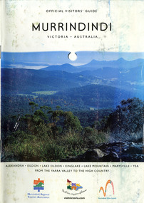
Booklet (Item) - Information booklet, Alexandra Newspapers, OFFICIAL VISITORS' GUIDE MURRINDINDI VICTORIA-AUSTRALIA, 03-2005
An information booklet on the Murrindindi region in Victoria. This information booklet was produced by Alexandra Newspapers in partnership with the Murrindindi Regional Tourism Association in March 2005.An information booklet on the Murrindindi region in Victoria.Produced and published by Alexandra Newspapers/ Pty Ltd in partnership with the Murrindindi Regional/ Tourism Association. murrindindi, victoria, australia, alexandra, eildon, kinglake, marysville, yea, yarra valley, high country, visit victoria, alexandra newspapers, murrindindi tourism association, rubicon valley horse riding, cathedral range state park, murrindindi scenic reserve, yarra ranges national park, cumberland memorial scenic reserve, the big culvert, cambarville, the big tree, steavenson falls, cora lynn falls, cumberland falls, lady talbot drive, phantom falls, keppel falls, the beeches, the cascades, wilhelmina falls, murrindindi cascades, lake mountain, cathedral lane vineyard, south cathedral farm, marysville holiday cottages, crystal journey, country touch, marysville ski centre, mountain lodge marysville, eco adventure tours, the mountain gallery, marysville country real estate, camellia log cabin, crossways historic country inn, marylands country house, ashlar cottage b&b, kerami guesthouse, melina cottages, willowbank at taggerty, mary lyn holiday resort, kooringa resort & conference centre, marysville caravan & holiday park, lyell guest cottages, eagle mountain retreat, keppels hotel motel, anastasia fairytale cottage, mystic mountain holiday cottages, esa camping & conference centre, buxton trout & salmon farm, woodlands rainforest bungalows, the old woolshed cafe, yarrolyn holiday park -
 Marysville & District Historical Society
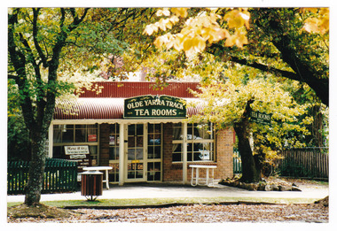
Photograph (Item) - Colour photograph, 14-04-2002
A colour photograph of the Olde Yarra Track Tea Rooms in Marysville in Victoria.A colour photograph of the Olde Yarra Track Tea Rooms in Marysville in Victoria. This building, along with most of the town, was destroyed in the 2009 Black Saturday bushfires.25/313 14.4.2002 AT MARYSVILLEmarysville, victoria, olde yarra track tea rooms, 2009 black saturday bushfires -
 Marysville & District Historical Society
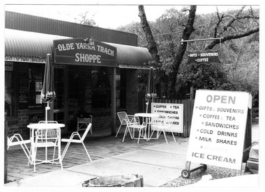
Photograph (Item) - Black and white photograph, Unknown
A black and white photograph of the Olde Yarra Track Shoppe in Marysville in Victoria.A black and white photograph of the Olde Yarra Track Shoppe in Marysville in Victoria. This building, along with most of the town, was destroyed in the 2009 Black Saturday bushfires.Mary Ferguson 70s + 80s.marysville, victoria, olde yarra track shoppe, 2009 black saturday bushfires -
 Marysville & District Historical Society
Photograph (Item) - Colour photograph, Unknown
A colour photograph of the outside of the Marysville Patisserie in Marysville in Victoria.A colour photograph of the outside of the Marysville Patisserie in Marysville in Victoria. The Marysville Patisserie was established in Falls Road in 2002. The Patisserie was known for its delicious light lunches, European-style cakes, and Yarra Valley fudge, all of which were made on the premises. The Patisserie, along with most of the businesses in Marysville, was destroyed in the 2009 Black Saturday bushfires.marysville patisserie, marysville, victoria, 2009 black saturday bushfires -
 Phillip Island and District Historical Society Inc.
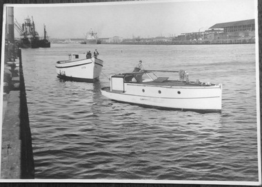
Photograph, Fishing boat, Penguin, launch on the Yarra River, 1940s
Matte black and white photo of the Penguin being towed on the Yarra RiverNillegg family, fishing boat- penguin, fishing boats -
 Eltham District Historical Society Inc
Photograph, Upper Yarra Dam, Spring Tour, 22 Oct 1995, 22/10/1995
EXPLORING THE UPPER YARRA (Newsletter No. 105, November 1995, by Bettina Woodburn) We enjoyed the Spring Excursion, this year "Exploring the Upper Yarra" - in spite of the constant rain and the countryside under the cloud cover, especially in the valleys, being mainly shiny shades of green. The occasional fields of buttercups, clumps of arum lilies and splendid rhododendron and other flowering bushes became very special. The Cobb and Co coach was warm and a cosy retreat as we zig-zagged on the highways and byways to glimpse the Yarra River, upstream and down, its secret places, and particularly the many bridges. Russell excelled as 'Poet Laureate', reading from Dacre Smyth's book. This 1979 publication includes paintings of all the bridges along the river with poems and brief descriptions of each one. Some of the bridges are in out of the way places and are not very well known. We looked forward to hearing the poetry as much as seeing the ' constructions'…Big Pat (was he short or tall, lean or fat? He did win the two hundred pound reward for discovering gold and had the creek named after him), about the 'Eddies'?, and the disliked 'meccano' bridge in Warburton, etc. etc. The hot roast lunch in the old Reefton Hotel was also most welcome. It was easy to imagine it peopled by miners and early settlers. Starting by crossing the new (1974) concrete bridge at Warrandyte we headed through Wonga Park with views to the Christmas Hills and to the escarpment of the Yering Gorge, which causes flood waters to back up through the Yarra Glen plain, so avoiding disasters downstream. At the end of a long driveway we found the wooden, privately owned Henley Bridge (1935 after the 1934 floods). This facilitates access to different parts of Henley Farm and to Lilydale. Everard Park, named after Blanche Shallard's father, a State Member for 17 years, below the Highway Yarra crossing was in need of care. It is 10 miles from Yarra Glen by road but, as "Yarra Marra” canoeists well know, 32 winding miles down by water. After more delightful countryside scenes we joined the Warburton Highway at Woori Yallock. From the old Railway Station at Launching Place the Centennial Trail for walkers, cyclists and ' horse riders has replaced the rails. The line from Lilydale was opened in 1901, and the last diesel freight train ran to Warburton in 1965. It continued to rain as we had morning tea in Warburton in a shelter between footbridges. From here we continued upstream past the Bridge to O'Shannasy Lodge and Reservoir, Starvation Creek, and the Peninsular tunnel (miners dug it as at Pound Bend) which we visited (scrambling down those steps!) on our return after lunch. Our furthermost point was the Upper Yarra Dam Reserve (and vast catchment area). Finished in 1957 after ten years work and 100 years after Yan Yean, it supplies much of Melbourne's water. After crossing the 30m Launching Place Bridge to the Eltham side of the Yarra and Healesville, we saw in the distance the Yarra Glen Timber Trestle Bridge over the river flats "the longest for years in the land it was said!" Harry's dream of "better weather over the Divide" unfortunately didn't come true, but I'm sure we 36 members will retain happy memories of a day that was wet and green and filled with Bridges. Bettina Woodburn - October 1995 Record of the Society's history of activities - Spring 1995 excursionRoll of 35mm colour negative film, 3 stripsKodak Gold 200-4shire of eltham historical society, activities, upper yarra dam, henley bridge -
 Eltham District Historical Society Inc
Photograph, Upper Yarra Dam, Spring Tour, 22 Oct 1995, 22/10/1995
EXPLORING THE UPPER YARRA (Newsletter No. 105, November 1995, by Bettina Woodburn) We enjoyed the Spring Excursion, this year "Exploring the Upper Yarra" - in spite of the constant rain and the countryside under the cloud cover, especially in the valleys, being mainly shiny shades of green. The occasional fields of buttercups, clumps of arum lilies and splendid rhododendron and other flowering bushes became very special. The Cobb and Co coach was warm and a cosy retreat as we zig-zagged on the highways and byways to glimpse the Yarra River, upstream and down, its secret places, and particularly the many bridges. Russell excelled as 'Poet Laureate', reading from Dacre Smyth's book. This 1979 publication includes paintings of all the bridges along the river with poems and brief descriptions of each one. Some of the bridges are in out of the way places and are not very well known. We looked forward to hearing the poetry as much as seeing the ' constructions'…Big Pat (was he short or tall, lean or fat? He did win the two hundred pound reward for discovering gold and had the creek named after him), about the 'Eddies'?, and the disliked 'meccano' bridge in Warburton, etc. etc. The hot roast lunch in the old Reefton Hotel was also most welcome. It was easy to imagine it peopled by miners and early settlers. Starting by crossing the new (1974) concrete bridge at Warrandyte we headed through Wonga Park with views to the Christmas Hills and to the escarpment of the Yering Gorge, which causes flood waters to back up through the Yarra Glen plain, so avoiding disasters downstream. At the end of a long driveway we found the wooden, privately owned Henley Bridge (1935 after the 1934 floods). This facilitates access to different parts of Henley Farm and to Lilydale. Everard Park, named after Blanche Shallard's father, a State Member for 17 years, below the Highway Yarra crossing was in need of care. It is 10 miles from Yarra Glen by road but, as "Yarra Marra” canoeists well know, 32 winding miles down by water. After more delightful countryside scenes we joined the Warburton Highway at Woori Yallock. From the old Railway Station at Launching Place the Centennial Trail for walkers, cyclists and ' horse riders has replaced the rails. The line from Lilydale was opened in 1901, and the last diesel freight train ran to Warburton in 1965. It continued to rain as we had morning tea in Warburton in a shelter between footbridges. From here we continued upstream past the Bridge to O'Shannasy Lodge and Reservoir, Starvation Creek, and the Peninsular tunnel (miners dug it as at Pound Bend) which we visited (scrambling down those steps!) on our return after lunch. Our furthermost point was the Upper Yarra Dam Reserve (and vast catchment area). Finished in 1957 after ten years work and 100 years after Yan Yean, it supplies much of Melbourne's water. After crossing the 30m Launching Place Bridge to the Eltham side of the Yarra and Healesville, we saw in the distance the Yarra Glen Timber Trestle Bridge over the river flats "the longest for years in the land it was said!" Harry's dream of "better weather over the Divide" unfortunately didn't come true, but I'm sure we 36 members will retain happy memories of a day that was wet and green and filled with Bridges. Bettina Woodburn - October 1995 Record of the Society's history of activities - Spring 1995 excursionRoll of 35mm colour negative film, 3 stripsKodak Gold 200-4shire of eltham historical society, activities, upper yarra dam, henley bridge