Showing 12619 items matching " development"
-
 Glen Eira City Council History and Heritage Collection
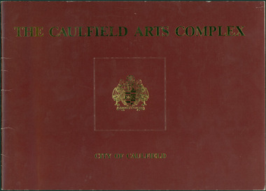
Document - Booklet, "THE CAULFIELD ARTS COMPLEX / CITY OF CAULFIELD", After 1987
Considered to be of historical and social significance. Provides information on the development of the current Town Hall Auditorium and the Glen Eira Gallery.1 x Maroon coloured booklet with gold lettering on cover published by the City of Caulfield. Inside are 14 paper pages with colour concept drawings of the proposed Caulfield Arts Complex, Concept Plans and printed text. Dated May 1987 in the opening page with an Introduction by the Mayor of Caulfield, Cr Jack Campbell. -
 Friends of Ballarat Botanical Gardens History Group
Work on paper - The Fernery, Ballarat Botanical Gardens, C 2003
This article gives a clear account of the development of the Fernery in the Ballarat Botanical Gardens from 1879 to the beginning of the 21st century. The Fernery remains a significant feature of the Ballarat Botanical Gardens, as it has been now for 143 years. The detail given in this article is valuable especially in terms of nineteenth century developments. 2 pages, 1&1/4 of print.There are 3 asterisks in the lefthand margin and 3 small edits.john garner, doctor, john garner collection, ballarat botanical gardens, friends of ballarat botanical gardens, fernery, "fern mania"., eugene von guerard, george longley, h.r.caselli, baron von mueller, james veitch, gardens, ballarat -
Friends of Ballarat Botanical Gardens History Group
Work on paper - Ballarat Botanical Gardens by Lake Wendouree, The Fernery (Palm House), C 2002
The article was produced by the Ballarat City Council entitled "The Fernery". It deals with developments, purpose and plans for the Fernery from 1955.This page testifies to the importance Ballarat City Council attached to the Fernery around the turn of the century and the plan to make it "the next landmark project", after the Australian Ex-POW Monument was finished in 2004.One page of 6 paragraphs in font 12.Logo, central top of page, "Ballarat Botanical Gardens by Lake Wendouree" in black and white.john garner, doctor, john garner collection, ballarat botanical gardens, the fernery, friends of ballarat botanical gardens, ballarat botanical gardens masterplan and management strategy, ballarat city council, gardens, ballarat -
 Friends of Ballarat Botanical Gardens History Group
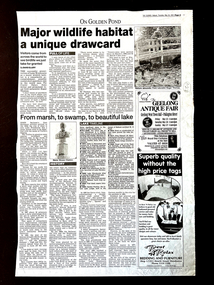
Work on paper - Major Wildlife Habitat: a unique drawcard. The Courier, Ballarat, 24/5/2001, From Marsh, to Swamp, to Beautiful Lake, 24/5/2001
The two articles are about Lake Wendouree, the first relates to the Lake as a major wildlife habitat and the second to the development of the Lake.Not only are there details of the Lake as a wildlife habitat, there is a detailed chronology and history of developments on and around Lake Wendouree.1 page of the Courier newspaper (p.5) with 2 major headings and a " Lake Timeline", 1/2 way down the page.Nonejohn garner, doctor john garner, ballarat botanic gardens, friends of ballarat botanical gardens, lake wendouree, wildlife habitat, yuille's swamp, ducks, grebes, native aquatic plants, white ibis, silver gull, possums, native water rats, history of lake wendouree., john garner collection, gardens, ballarat -
 Friends of Ballarat Botanical Gardens History Group
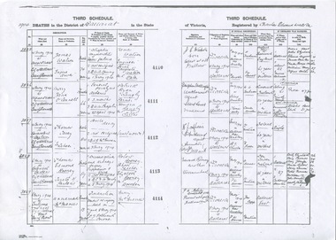
Work on paper - Death Certificates of People Associated with the Ballarat Botanical Gardens 1880-1910, Medical Diagnosis Related to Contemporary Documentation and Reports
The Death Certificates discussed are of notable people who made important contributions to the establishment and development of the Ballarat Botanical Gardens.The analysis of the death certificates provides insights not only to the practice of medicine at the turn of nineteenth century Ballarat but into the lives and state of health of a few important people at that time.5 typed pages of a talk in black ink.Several "typos" corrected in black biro, pp.2,3,and 4.john garner collection, garner, dr, death, certificate, ballarat botanical gardens, gardens, ballarat, personalities, claxton, ham, mcdonald, morey, rooney, stoddart, thomson, cause of death, statistics -
Kadimah Jewish Cultural Centre and National Library
Programme, A NIGHT OF FILMS AND THEATRE
A NIGHT OF FILMS AND THEATRE, DEVELOPMENT OF YIDDISH FILMS, SHOLEM ALEICHEM'S ONE ACT PLAY 'MENTSHN' JUNE 1982Theatre programm.szmerling, j.chaberman, i. lustig, a.wygushin, t.rosenbloom, m.ceprow, r. levita, m.pfau, c. meerkin, r.kenigsztajn -
 Greensborough Historical Society
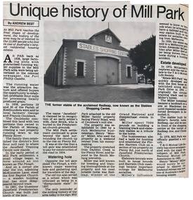
Newspaper - Newspaper Clipping - Digital Image, Andrew Best, Unique history of Mill Park, 1990s
A short history of the development of Mill Park, including information on the Coulstock family and the historic stables, now a shopping centre.Digital copy of newspaper articlemill park, the stables mill park, coulstock family, redleap -
University of Melbourne, Burnley Campus Archives
Newspaper - Newspaper Cutting, The Age, Child Play Areas in New Housing, 1961
Margaret Hendry (Graduated 1948, Staff 1950-1952). Landscape Assistant for the Basildon Development Corporation in Essex, UK.Article in "The Age" September 27, 1961 about Margaret Hendrythe age, margaret hendry, landscape designer, student, basildon development corporation -
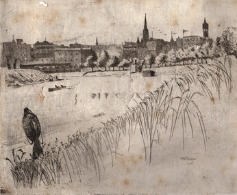 Ballarat Heritage Services
Photograph - Artwork, 'The Yarra" by John Shirlow, 1900
John SHIRLOW (1869-1936) Melbourne born John Shirlow made a significant contribution to the development of etching in Australia.Framed etching by John Shirlowtownscape, john shirlow, etching, printmaking, yarra river, bridge -
 Eltham District Historical Society Inc
Audio - Audio Recording, Audio Recording; 2018-12-09 Eltham Community Town Hall Meeting, 9 Dec 2018
Second information meeting regarding the Shire of Nillumbik's proposed development/sale of 895 and 903-907 Main Road0:37:56 duration Digital MP3 File 13.0 MB 895 main road, 903-907 main road, community meeting, eltham pre-school, eltham shire office, eltham war memorial, eltham war memorial hall, infant welfare centre, nillumbik shire council, senior citizen's centre -
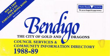 Bendigo Historical Society Inc.
Book - BOOKLET: ''BENDIGO THE CITY OF GOLD AND DRAGONS'' (1988-89)
45 paged booklet - ''Bendigo - The City of Gold and Dragons'' (1988-89)- a Council services and community information directory. Contents : Mayor's message; City of Bendigo; Exciting current developments; Council meeting times; Your councillors; Corporate plan; Chief Executive Officer's message; Corporate Services Department; Rates and valuations; Revaluation; Tourism; Parking and traffic control; Dogs; By-laws; Community development; Library; Health and Human Services Department; Child Care centres; Home Care services; Leisure; Engineering and Technical Services Dept.; Town planning; Building; Parks and recreation; Shopping guide/car parking; Discount shopping vouchers; Operations Department; Street lighting; Garbage collection. Photographs of councillors and Departmental managers/directors.bendigo, council, community information directory, cr. r. adams, colin nankervis, michael currie, james douglass, phillip geri, rodney fyffe, jeffrey fyffe, peter morley, chris wilson. rates and valuations, parking, by laws, shopping. departmental managers and directors. -
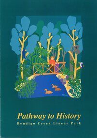 Bendigo Historical Society Inc.
Pamphlet - MERLE HALL COLLECTION: ROSALIND PARK CREATIVE VILLAGE BENDIGO PROJECT PAMPHLET, 1993
MERLE HALL COLLECTION: ROSALIND PARK CREATIVE VILLAGE BENDIGO PROJECT PAMPHLET Pathway to History Bendigo Creek Linear Park Inside pages - Graphic image of the Linear Park from Alexandra Fountain to the Botanical Gardens, includes Rosalind Park, Golden Dragon Museum, Shamrock Hotel, Bendigo Gas Works, Chinese Joss House, Chinese Tea House, Lake Weroona, Wetlands, White Hill Cemetary and mine sites. On outside pages, cover, historical notes on Bendigo and Notes on the Bendigo Creek Linear Park. Notes on the back cover: A joint project of the City of Greater Bendigo and the Department of planning and development. Production by the Publick Affairs Branch, Department of Planning and Development. Printed in Bendigo June 1993 4360/93. -
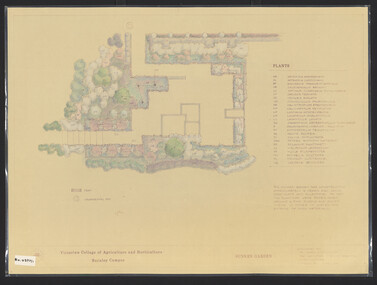 University of Melbourne, Burnley Campus Archives
Plan, James Hitchmough, Sunken Garden, 1981-1989
Most plans were held in Geoff Olives's office.(1) Sunken Garden. 1 tracing paper copy and 1 paper, laminated, coloured. Designed by Dr. James Hitchmough, drawn by Jill Kellow c1989. Plants supplied by Victorian Wholesale Nurseries Pty. Ltd. (2) The Sunken Garden. 1 tracing paper, partly coloured, 1 paper copy. Designed by James Hitchmough, drawn by Jill Kellow 20.12.1988. (3) Burnley Horticultural College Gardens Development Sunken Gardens: Plan Proposal I, March 1981 on tracing paper. (4) Burnley Horticultural College Gardens Development Formal Sunken Garden Proposal 2, March 1981 on tracing paper. (5) Burnley Horticultural College Sunken Garden Scheme II by G. Olive on tracing paper. Plants supplied by Victorian Wholesale Nurseries P.L. sunken garden, james hitchmough, jim kellow, andrew smith -
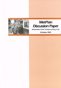 Melbourne Tram Museum
Document - Report, The Met, "MetPlan discussion Paper - Metropolitan Public Transport Industry Plan, Oct. 1987
Report or discussion paper, 76 pages printed on off white paper, with card cover, centre stapled, titled "MetPlan discussion Paper - Metropolitan Public Transport Industry Plan - October 1987". Prepared by Metropolitan Transit authority and Ministry of Transport, signed by the Kevin Shea as Managing Director the MTA. Has a summary of contents, table of contents, many figures and tables (see images 2 and 3). Looks at the current policies and objectives, Melbourne's urban development and public transport system, financial and staff picture, future public transport needs and planning the development of a future service. Gives details of book designers and printers on the last page. Second copy from donation of John Prideaux added 24-6-2016trams, tramways, metplan, minister for transport, public transport, the met, mta, melbourne -
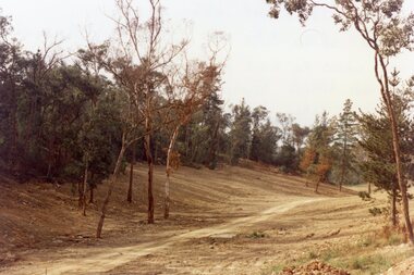 Ringwood and District Historical Society
Photograph, Kubis Estate, North Ringwood in April 1978. View of the lake site looking east. The wall was where the track bends. The rope tree was on the hillside beyond the track bend
E548 N35 This photo was taken from almost the same spot as the 1976 one. Part of a 51-photo record of the development of the "Kubis" Estate, Ringwood North, including road works to Debbie Place, Kubis Drive, Werac Drive, Manuelo Drive, Iluka Place and Glenvale Road. From the Jack Lundy Clarke collection. -
Glenelg Shire Council Cultural Collection
Administrative record - Survey - Industrial and Commercial Potential of Portland, Victoria, Apr-71
-
 Whitehorse Historical Society Inc.
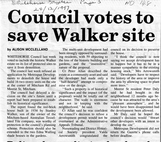
Article, Council votes to save Walker site, 24/12/1997 12:00:00 AM
Whitehorse Council last week voted to include the historic Walker EstateCutting from Whitehorse Gazette 24/12/1997 informing that Whitehorse Council last week voted to include the historic Walker Estate on its list of protected sites to save it from demolition. Cr Allen said he was confident the Council's decision to refuse a development permit would not be overturned at the Administration Appeals Tribunal. Whitehorse Council last week voted to include the historic Walker Estatewalker estate, city of whitehorse, metrospan developments, walker, stanley, mitcham road, mitcham, meerut street, australian tesselated tile co pty ltd, walling, edna, allan, peter, nunawading and district historical society, arrowsmith, valda, daly -
 Whitehorse Historical Society Inc.
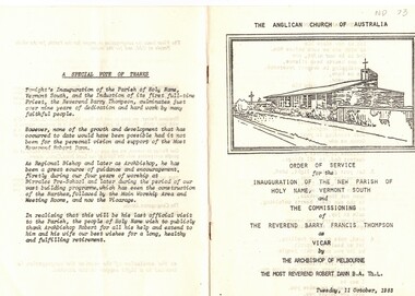
Document, Parish of Holy Name, 1/10/1983
Order of Service for the inauguration of the new Parish of Holy Name, Vermont south and the commissioning of Reverend Barry Francis Thompson as Vicar by the Archbishop of Melbourne, the Most Reverend Robert Dann on Tuesday, 11 October, 1983. a tribute is included to the involvement of Archbishop Robert Dann over the previous nine years to the development of the Parish. 12 pagesholy name anglican church, vermont south;, dann, robert, rev., thompson, barry francis -
 Bendigo Historical Society Inc.
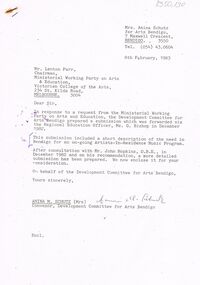
Document - MERLE HALL COLLECTION: SUBMISSION RE ARTISTS IN RESIDENCE MUSIC PROGRAM (1983)
Submission re Artists-In-Residence Music Program (1983) - Supporting letter from Mrs Amina Schutz, Convenor, Development Committee for Arts Bendigo 8th Feb 1983. Submission covers - Description of the proposed program; Justification for the program; Recommendations plus Support for the program (names and position). Follows an earlier submission in Dec 1982. -
Port Melbourne Historical & Preservation Society
Booklet, State Government of Victoria, Making the Most of the Bay, 1990
Making the Most of the Bay - Plan for the protection and development of Port Phillip and Corio Bays, November 1990. An A4 booklet considering environment, land use and settlement, recreation and tourism, coastal and marine industries. Detailed recommedations for specific areas and foreward by Ministers Steve Crabb and Andrew McCutcheon (ref. item 1414, draft version)state government victoria, natural environment - conservation -
 Bendigo Historical Society Inc.
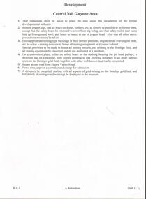
Document - CENTRAL NELL GWYNNE MINE - CENTRAL NELL GWYNNE AREA DEVELOPMENT
Typed notes on the development of the Central Nell Gwynne Area for tourism. Mentions restoration of poppet legs, extending safety braces, erect mining type buildings in their correct positions, engine-house over engine-beds, etc to act as a mining museum and to compile a directory dealing with all aspects of gold-mining on the Bendigo goldfield.mine, gold, central nell gwynne mine, central nell gwynne mine, central nell gwynne area development -
 Kew Historical Society Inc
Photograph - 8 Kellett Grove, North Kew, 1929
North Kew, now divided between Kew and Kew East, bordered the Yarra River. As such, it was a region subject to flooding in the Yarra Valley. Development beyond this point (ie Kellett Grove) was limited by the City of Kew's planning regulations. Prior to urban development, the area since European settlement and the first land sales in the district in the 1840s, had been used for dairy farming. Small sepia snapshot taken of the front of 8 Kellett Grove, in what was then known as North Kew. Verso: 8 KELLETT GROVE / NORTH KEW / 1929 / 418 kellett gove -- north kew, californian bungalows, houses -- kellett grove -- kew (vic.) -
 Kew Historical Society Inc
Photograph - Flooding of the Yarra River in North Kew, 1934
North Kew, now divided between Kew and Kew East, bordered the Yarra River. As such, it was a region subject to flooding in the Yarra Valley. Development beyond this point (ie Kellett Grove) was limited by the City of Kew's planning regulations. Prior to urban development, the area since European settlement and the first land sales in the district in the 1840s, had been used for dairy farming. Small sepia snapshot taken from the back yard of a house at 8 Kellett Grove, in what was then known as North Kew. The point of view is from a backyard looking towards Fairfield. Floodwaters have submerged the fence and a clothes line. Verso: BACKYARD NTH. KEWyarra river -- north kew, floods -- yarra valley, floods -- north kew, floods -- 1934, natural disasters -- kew -
 Kew Historical Society Inc
Photograph - Flooding of the Yarra River in North Kew, 1934
North Kew, now divided between Kew and Kew East, bordered the Yarra River. As such, it was a region subject to flooding in the Yarra Valley. Development beyond this point (ie Kellett Grove) was limited by the City of Kew's planning regulations. Prior to urban development, the area since European settlement and the first land sales in the district in the 1840s, had been used for dairy farming. Small sepia snapshot taken from the back yard of a house at 8 Kellett Grove, in what was then known as North Kew. The point of view is from a backyard looking towards Fairfield. Verso: 8 KELLETT GROVEyarra river -- north kew, floods -- yarra valley, floods -- north kew, floods -- 1934, natural disasters -- kew -
 Kew Historical Society Inc
Photograph - Flooding of the Yarra River in North Kew, 1934
North Kew, now divided between Kew and Kew East, bordered the Yarra River. As such, it was a region subject to flooding in the Yarra Valley. Development beyond this point (ie Kellett Grove) was limited by the City of Kew's planning regulations. Prior to urban development, the area since European settlement and the first land sales in the district in the 1840s, had been used for dairy farming. Small sepia snapshot taken from the back yard of a house at 8 Kellett Grove, in what was then known as North Kew. The point of view is from a backyard looking towards Fairfield. Verso: OUR BACKYARD 8 KELLETT GROVEyarra river -- north kew, floods -- yarra valley, floods -- north kew, floods -- 1934, natural disasters -- kew -
 Kew Historical Society Inc
Photograph - View of the Yarra River from 8 Kellett Grove, North Kew, 1948
North Kew, now divided between Kew and Kew East, bordered the Yarra River. As such, it was a region subject to flooding in the Yarra Valley. Development beyond this point (ie Kellett Grove) was limited by the City of Kew's planning regulations. Prior to urban development, the area since European settlement and the first land sales in the district in the 1840s, had been used for dairy farming. The view from the rear of 8 Kellett Grove predates the construction of the Eastern Freeway so provides a rare view of the area before it was built.Small sepia snapshot taken from the back yard of a house at 8 Kellett Grove, in what was then known as North Kew. A tower of the Kew Asylum on the top left of the horizon assist the viewer to recognise that the land to the left of the river is in Kew and Studley Park.Verso: NORTH KEW 1948 / Stamped 51019yarra river -- north kew, kellett grove -- north kew -
 Kew Historical Society Inc
Photograph - Flooding of the Yarra River in North Kew, 1934
North Kew, now divided between Kew and Kew East, bordered the Yarra River. As such, it was a region subject to flooding in the Yarra Valley. Development beyond this point (ie Kellett Grove) was limited by the City of Kew's planning regulations. Prior to urban development, the area since European settlement and the first land sales in the district in the 1840s, had been used for dairy farming. Small sepia snapshot of floodwaters taken from near Kellett Grove, in what was then known as North Kew. The point of view is from a backyard looking towards Fairfield. In the foreground ar two men in a rowboat.Verso: OUR BACKYARD / Stamped 3 163yarra river -- north kew, floods -- yarra valley, floods -- north kew, floods -- 1934, natural disasters -- kew -
 Kew Historical Society Inc
Photograph - Flooding of the Yarra River in North Kew, 1934
North Kew, now divided between Kew and Kew East, bordered the Yarra River. As such, it was a region subject to flooding in the Yarra Valley. Development beyond this point (ie Kellett Grove) was limited by the City of Kew's planning regulations. Prior to urban development, the area since European settlement and the first land sales in the district in the 1840s, had been used for dairy farming. Small sepia snapshot of floodwaters taken from near Willsmere Road, in what was then known as North Kew. The point of view is looking towards Fairfield. In the foreground are two figures viewing a group in a rowboat in the middle of the flooded river. Semi-submerged street lighting indicates that entire streets had been. overwhelmed by the flood waters. Verso: WILLSMERE ROAD NORTH KEW / Stamped 3 163yarra river -- north kew, floods -- yarra valley, floods -- north kew, floods -- 1934, natural disasters -- kew, willsmere road -
 Kew Historical Society Inc
Photograph - Flooding of the Yarra River in North Kew, 1934
North Kew, now divided between Kew and Kew East, bordered the Yarra River. As such, it was a region subject to flooding in the Yarra Valley. Development beyond this point (ie Kellett Grove) was limited by the City of Kew's planning regulations. Prior to urban development, the area since European settlement and the first land sales in the district in the 1840s, had been used for dairy farming. Small sepia snapshot of floodwaters in North Kew. The point of view is of two houses belonging to local families that were surrounded by floodwater. Verso: HYATTS HOUSE / WILLSMERE ROAD / Stamped 3 163yarra river -- north kew, floods -- yarra valley, floods -- north kew, floods -- 1934, natural disasters -- kew, willsmere road -
 Kew Historical Society Inc
Photograph - Flooding of the Yarra River in North Kew, 1934
North Kew, now divided between Kew and Kew East, bordered the Yarra River. As such, it was a region subject to flooding in the Yarra Valley. Development beyond this point (ie Kellett Grove) was limited by the City of Kew's planning regulations. Prior to urban development, the area since European settlement and the first land sales in the district in the 1840s, had been used for dairy farming. Small sepia snapshot of floodwaters in North Kew, from the rear of 8 Kellett Grove. Verso: OUR BACKYARD / Stamped 52yarra river -- north kew, floods -- yarra valley, floods -- north kew, floods -- 1934, natural disasters -- kew, willsmere road