Showing 10388 items
matching plan
-
 University of Melbourne, Burnley Campus Archives
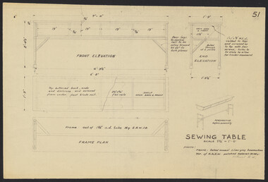
Plan, Sewing Tables, 1958
Plans. A. Sewing Table No. 51 B. Table for Electric Sewing Machines by Chief Architect, Public Works Dept.sewing, tables, machines -
 University of Melbourne, Burnley Campus Archives
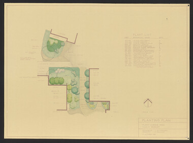
Plan, Bolobek, c. 1970
Photocopy of p 47 from book (unknown) showing Garden Plan, tracing paper and reduced size copy. 'Bolobek' handwritten on revese of photocopy.bolobek, gardens, landscape design -
University of Melbourne, Burnley Campus Archives
Plan, Gerner Sanderson Faggetter Cheesman, Hay's Paddock, 1981
Sketch Plan dated September 1981, by Gerner Sanderson Faggetter Cheesman, Drawing No 200.01. Scale 1:100.gerner sanderson faggetter cheesman, hay's paddock, kew, parks -
University of Melbourne, Burnley Campus Archives
Plan, Melbourne Girls College, 1980s?
Coloured, laminated, Concept Plan for Courtyard between Portables and East Elevation Main Building. Scale 1:100. Student: Redna Moore, on reverse.melbourne girls college, redna moore, students, courtyard -
 University of Melbourne, Burnley Campus Archives
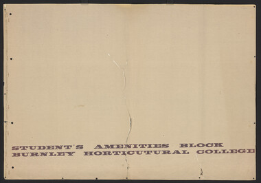
Plan, D.C. Bradbury, Student's Amenity Block Burnley Horticultural College, 1971
Site Plan First Floor Elevations by D.C. Bradbury, Public Works Department Building Division, Victoria 28.7.1971.students, amenities -
Ringwood and District Historical Society
Envelope, Packet: Planning - Ringwood and Croydon Clippings and Newspaper 1978-1983, 1978-1983
Planning - Ringwood and Croydon -
 Federation University Historical Collection
Plans, Ballarat School of Mines Old Chemistry Building
Images of photocopied plans.ballarat school of mines, buildings, old chemistry building -
University of Melbourne, Burnley Campus Archives
Booklet - Brochure, Botanic Gardens Queen Victoria Gardenss Alexandra Park, 1924
Brochure and plan of gardensgardens -
Creswick Campus Historical Collection - University of Melbourne
Document, 1933
Creswick Working Plan -
 Friends of Ballarat Botanical Gardens History Group
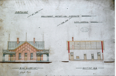
Photograph - Digital image - jpg, Gardens Pavilion design, Ballaarat
colour photograph of planpavilion plan, ballaarat botanical gardens, circa 1890 -
 Melton City Libraries
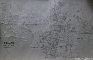
Map, Coimadai County of Bourke, 1911
Town Plan of Meltoncouncil -
Whitehorse Historical Society Inc.
Document, Monier Wunderlich Tile Factory, 1989-96
Papers concerning sub-division of the former Monier-Wunderlich Tile Factory site.Papers concerning sub-division of the former Monier-Wunderlich Tile Factory site between Rooks and Mitcham Roads Vermont. Includes City of Nunawading planning documents and correspondence with residents; Wunderlich Residents' Action Group circulars; correspondence and drafts by W & B Gray relating to the proposals.Papers concerning sub-division of the former Monier-Wunderlich Tile Factory site. wunderlich limited, monier-redlands pty ltd, mitcham road, mitcham, rooks road, vermont, nos. 147-157, wunderlich residents' action group, rosstrevor crescent, mitcham, redlands properties, gray, william, gray, beryl -
 Kew Historical Society Inc
Photograph - Double-fronted Edwardian Villa, c.1918
The Kew Historical Society's map collection includes a substantial number of real estate subdivision plans, mainly of Kew but also of surrounding suburbs in Melbourne. Most of the subdivision plans date from the 1920s and 1930s when the districts old homes and local farmland were being split up to accommodate residential growth in the postwar period. These early plans were assembled by a local firm, Jas R Mather & McMillan, which had an office in Cotham Road. Many of the plans, and sometimes photos, were annotated by the agents.Subdivision plans are historically important documents used as evidence for the growth of suburbs in Australia. They frequently provide information about when the land was sold as well as evidence relating to surveyors and real estate and financial agents. The numerous subdivision plans in the Kew Historical Society's collection represent working documents, ranging from the initial sketches made in planning a subdivision to printed plans on which auctioneers or agents listed the prices for which individual lots were sold. In a number of cases, the reverse of a subdivision plan in the collection includes a photograph of a house that was also for sale by the agent. These photographs provide significant heritage information relating house design and decoration, fencing and household gardens.The photograph may also be aesthetically significant depending on the importance of the photographic atelier.On the reverse of a subdivision plan of the Palmyra Estate (Kew) is a photograph of a double-fronted Edwardian villa. The weatherboard and stucco house with high brick chimneys provides a clear indication of the style of curtains and gardens in houses of the period. Holland blinds with lace inserts are used in the left front window. They are combined with long lace curtains. The garden, with its curved pathway is bordered with garden beds that include marguerite daisies and roses. Reflecting a new interest in the Australian landscape, tree ferns and ground ferns are planted closer to the house.houses - kew, architecture - edwardian, real estate photographs -
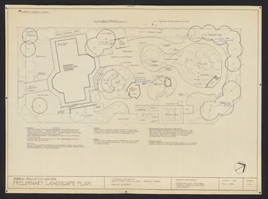 University of Melbourne, Burnley Campus Archives
Plan, Steve Mullany, Energy Education Centre, 1988
(1) Tracing paper and paper plans, Preliminary Landscape Plan by Steve Mullany, Lecturer Amenity Horticulture Dept. V.C.A.H. Burnley, Sheet 1 of 1 May 2, 1988. (2) 1 tracing paper and 2 paper copies State Schools' Nursery: Proposed Landscape Working Drawing Energy Education Centre Burnley by E.A.H. June 1988. (3) 2 copies State Schools' Nursery: Proposed Landscape Working Drawing Energy Education Centre Burnley, by EAH 18 June 1988 (Details). (4) 2 copies as (3) Pond Plans & Details 16 June 1988. (5.) Designs for small plans of above.vcah, steve mullany -
Federation University Historical Collection
Booklet, Ballarat School of Mines Report to Council on Possible Future Building Developments, 1965, 1965
A foolscap plan with a number of plans relating to possible future building developments at the Ballarat School of Mines. Includes proposed plan for the former M.B. John Site (neaar brew tower)ballarat school of mines, buildings, building developments, e.j. barker, library, engineering and applied science, gaol residences, trades, ballarat junior technical school, materials testing laboratory, martin report, hickman street -
Bendigo Historical Society Inc.
Plan - SANDHURST BOYS CENTRE COLLECTION: SANDHURST TRAINING CENTRE BUILDING PLANS
Sandhurst Training Centre residential unit ground floor plan and elevations; prepared by Public Works Department for the Government of Victoria. 21/8/1969. Includes floor plan for residential units nos 1,4,5 comprising 12 bedrooms, 2 toilet blocks, living hall, crafts and tea room, laundry. The plan for units 2,3,6 is a mirror image. Also included are elevations for north, south, east and west views. Drawn Aug 1968 Location unknown 16.02.2023.bendigo, institutions, sandhurst boys centre, sandhurst boys centre plans; -
 Kew Historical Society Inc
Plan - Subdivision Plan, Erin Heights Estate, East kew, 1917
Pru Sanderson, in her groundbreaking ‘City of Kew Urban Conservation Study : Volume 2 - Development History’ (1988), summarised the periods of urban development and subdivisions of land in Kew. The periods that she identified included 1845-1880, 1880-1893, 1893-1921, 1921-1933, 1933-1943, and Post-War Development. These periods were selected as they represented periods of rapid growth or decline in urban development. An obvious starting point for Sanderson’s groupings involved population growth and the associated economic cycles. These cycles also highlighted urban expansion onto land that was predominantly rural, although in other cases it represented the decline and breakup of large estates. A number of the plans in the Kew Historical Society’s collection can also be found in other collections, such as those of the State Library of Victoria and the Boroondara Library Service. A number are however unique to the collection.The Kew Historical Society collection includes almost 100 subdivision plans pertaining to suburbs of the City of Melbourne. Most of these are of Kew, Kew East or Studley Park, although a smaller number are plans of Camberwell, Deepdene, Balwyn and Hawthorn. It is believed that the majority of the plans were gifted to the Society by persons connected with the real estate firm - J. R. Mathers and McMillan, 136 Cotham Road, Kew. The Plans in the collection are rarely in pristine form, being working plans on which the agent would write notes and record lots sold and the prices of these. The subdivision plans are historically significant examples of the growth of urban Melbourne from the beginning of the 20th Century up until the 1980s. A number of the plans are double-sided and often include a photograph on the reverse. A number of the latter are by noted photographers such as J.E. Barnes.The Erin Heights Estate in Kew included just seven lots in in Valerie Street. These were all that remained of this wartime subdivision, the other 11 allotments on Balfour and Belford Roads having already been sold. Balfour Road was to be only a temporary name as the street is currently called Windella Avenue. Now, the parkland opposite the subdivision is the reserve created from the route of the Outer Circle Railway. This Railway reached Kew East in 1925, but had been planned as far back as 1873. The development focuses on the benefits of living in Kew: being at the highest of Kew’s ‘suburbs’; being a good residential area; its rapid growth; and the proximity of the Kew East tram in High Street. In 1917, the electric tramline only extended to a terminus at the Harp of Erin hotel. The terminus is clearly represented on the plan.subdivision plans - east kew, erin heights estate -
 Victorian Aboriginal Corporation for Languages
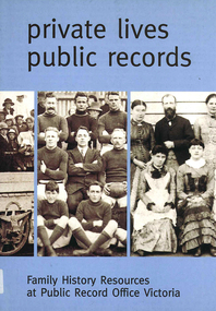
Book, Private lives, public records : family history resources at Public Record Office Victoria, 2003
Intended as a key resource for both first-time and experienced genealogists. It offers an introduction to the role, services and collection of Public Record Office Victoria, and a guide for family history researchers using the archives.colour photographs, b&w photographs, charts, letters, records, maps, plansgenealogy, local history, family history, public records, bibliographies, catalogues, victorian history -
 Robin Boyd Foundation
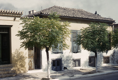
Slide, Robin Boyd, 1950
Penleigh Boyd, Robin and Patricia Boyd's son, writes “Prior to 1950 Robin, like most other amateur or hobby photographers, took black and white printed photographs. The oldest slides date from 1950 when Robin and Patricia travelled to Europe on Robin’s Robert Haddon Travelling Scholarship.” In 1948 Robin Boyd was awarded ‘joint first place’ in the Robert Haddon competition for his design of Mildura art gallery. The scholarship helped fund their first overseas trip. Robin and Patricia were passengers on the Greek ship “Cyrenia” departing in May 1950, passing through the Suez Canal and landing in Genoa five weeks later. For six months, they travelled extensively throughout Europe (predominantly driving themselves) - France, Italy, United Kingdom, Sweden, Denmark, Germany, Austria, Switzerland and Spain.Colour slide in a mount. Two-storey house in Piraeus, GreeceGreece / House / House in Pyraeus, 2-Storey Living Plan (All Handwritten)haddon travelling scholarship, haddon, robin boyd, slide -
Clunes Museum
Document, VICTORIAN GOVERNMENT DEPT. OF PLANNING, THE RURAL LAND MAPPING PROJECT 1981 - DRAFT, JULY 1981
A REPORT TO THE SHIRE OF TALBOT AND CLUES TO ACCOMPANY AND EXPLAIN THE SET OF PHYSICAL CONSTRAINTS MAPS PRODUCED FOR THE SHIRE AS PART OF THE RURAL LAND MAPPING PROJECT...SOFT COVER, TAN COLOURED DRAFT OF THE RURAL MAPPING PROJECT 1981 - SHIRE OF TALBOT AND CLUNES.non-fictionA REPORT TO THE SHIRE OF TALBOT AND CLUES TO ACCOMPANY AND EXPLAIN THE SET OF PHYSICAL CONSTRAINTS MAPS PRODUCED FOR THE SHIRE AS PART OF THE RURAL LAND MAPPING PROJECT...local history, government, state government, essential services -
University of Melbourne, Burnley Campus Archives
Plan, Richmond Primary School 'Prep Garden', 1994
(1) Coloured Section Elevation and Detail Suggestion by Frances Saunders August 1994. (2) Coloured Preliminary Plan, Landscape Graphics by Rachel Dann dated 16.8.94. Scale 1:50. (3) Site Analysis & Inventory. Scale 1:50. (4) 2 copies, 1 coloured, Section Elevations by N. Herzberg. Scale 1:50. (5) Coloured plan, Secret Garden by Julie Tydens p3 of 3 dated 22.8.94. Scale 1:50. (6) Coloured Preliminary Plan by Jacinta Chong Sheet 3 of 3 dated 22 Aug 1994. Scale 1:100. (7) 2 tracing paper and 1 paper Site Plan drawn by JK. Scale 1:50 and 1:100. (8) Coloured Section Elevation for Landscape Graphics by Rachel Dann dated 22.08.1994. Scale 1:50. (9) Coloured Preliminary Plan dated August 1994 by Frances Saunders. Scale 1:100. (10) Preliminary Plan Sheet No 3 of 3 dated 18.08.1994 by Ian Porterfrances saunders, rachel dann, julie tydens, jacinta chong, ian porter, richmond primary school, gardens, jill kellow -
Federation University Historical Collection
Report, Ballarat School of Mines Report, 1978, 03/1978
Report from the Ballarat School of Mines Planning Officer roles, responsibilites and rationale. Planning Document 1.78ballarat school of mines, planning documet, \j.l. turner -
 Robin Boyd Foundation
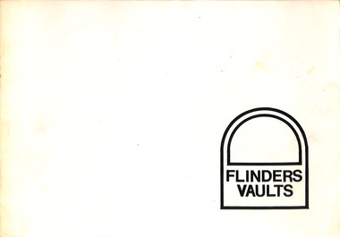
Booklet - Proposal, Robin Boyd, Flinders Vaults, Jan-72
Project: Flinders Vaults drawn by Robin Boyd of Romberg and Boyd.Booklet, 8 pages, with text and drawings (site plan. plan elevations, interior perspectives, external perspective). -
 University of Melbourne, Burnley Campus Archives
Plan, Student Amenity Building (Citriodora) Courtyard, 1988-2000
Various plans for what is now known as the "Citriodora Courtyard." I copy tracing paper, 1 coloured original, 4 copies with additional notation 6 smaller copies with additional notation. (1) Planting Plan Plant Science Area V.C.A.H. Burnley designed by J. Hitchmough, drawn by S. Mullany 3 October 1988. (2) Student Amenity Quad Sketch Proposal by M. Green May '95. (3) Rough pencil design, New Design related to Horticultural pursuits of Burnley College. (4) Coloured, Proposed Citriodora Court Redevelopment. (5) 2 copies Citriodora Courtyard Presentation Concept Plan by Adrian Bonifacio. November 2000. (6) Landscape Graphics II Assoc. Diploma in Horticulture (Amenity) Assignment 2 - Planting Plan May 1988. (7) Laminated, Preliminary Plan 2 of 4 Citriodora Lawn Burnley by Kate Szmal B.A.S.H. (8) Laminated, Preliminary Plan Student Amenity Building Courtyard V.C.A.H. Burnley by Caroline Lodge. (9) 1 tracing paper and 1 paper copy University of Melbourne Burnley College Student Amenity Building Courtyard 19.8.99. (10) Setout Plan, Planting Plan & Surface Finishes, Details Courtyard & Entrance, ACM Landscape Architecture: Concrete Paving Topsoil, Mulch - notes. "Phil Tulk," handwritten on reverse. (11) Laminated, V.C.A.H. Preliminary Plan p3 of 5 Project No 1 Student Amenity Building Courtyard by K. Watson 15-8-95. (12) Citriodora Courtyard Redevelopment Concept Plan by Judy Brookes November 2000. 2 copies of Drawing 1 of 2, 1 copy Drawing 2 of 2. (13) Proposed Outdoor Eating Area Student Amenities Block: Scheme 1 pp 2-5 of 5, 16.10.96. Scheme 2 pp 3-5 of 5, 16.10.96. Scheme 8 3 copies p1 of 2, 2 copies p2 of 2, 23.6.97, Paving Types p1 of 1, 30.9.99, handwritten on reverse,"to Phil from Nicki." (14) 2 copies Entry from Rear Car Park Paving Plan. (15) Plan by Margaret Kitching 8.8.90. citriodora courtyard, vcah -
 Kew Historical Society Inc
Plan - Subdivision Plan, Forres Estate, East Kew, 1919, 1919
Pru Sanderson, in her groundbreaking ‘City of Kew Urban Conservation Study : Volume 2 - Development History’ (1988), summarised the periods of urban development and subdivisions of land in Kew. The periods that she identified included 1845-1880, 1880-1893, 1893-1921, 1921-1933, 1933-1943, and Post-War Development. These periods were selected as they represented periods of rapid growth or decline in urban development. An obvious starting point for Sanderson’s groupings involved population growth and the associated economic cycles. These cycles also highlighted urban expansion onto land that was predominantly rural, although in other cases it represented the decline and breakup of large estates. A number of the plans in the Kew Historical Society’s collection can also be found in other collections, such as those of the State Library of Victoria and the Boroondara Library Service. A number are however unique to the collection.Subdivision plans are historically important documents used as evidence of the growth of suburbs in Australia. They frequently provide information about when the land was sold on which a built structure was subsequently constructed as well as evidence relating to surveyors and real estate and financial agents. The numerous subdivision plans in the Kew Historical Society's collection represent working documents, ranging from the initial sketches made in planning a subdivision to printed plans on which auctioneers or agents listed the prices for which individual lots were sold. In a number of cases, the reverse of a subdivision plan in the collection includes a photograph of a house that was also for sale by the agent. These photographs provide significant heritage information relating house design and decoration, fencing and household gardens.An annotated subdivision plan for the Forres Estate, Kew East. The estate was advertised in 1919, the Melbourne Auctioneers being represented locally by Henry Kellett, Estate Agent of High Street, Kew. The name of the estate was derived from the mansion (demolished 2016) of the same name in Normanby Road, which was at one stage owned by the Mayor of Kew, Cr. J. S. Were.subdivision plans - kew, forres estate, argyle road, simpson street, hubert street, normanby road -
 Bendigo Historical Society Inc.
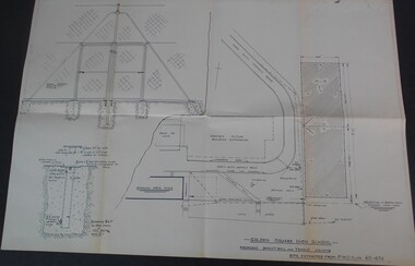
Plan - GOLDEN SQUARE HIGH SCHOOL COLLECTION: PLAN BASKETBALL AND TENNIS COURTS
Golden Square High School proposed basketball and tennis courts site extracted from P.W.D. plan 65-474education, secondary, golden square -
Port Melbourne Historical & Preservation Society
Plan - Outer berth Passenger Terminal fit-out, Station Pier, PMA, P B Keighran, Port of Melbourne Authority, 1987
Port of Melbourne Authority revised floor and section plans for Station Pier Outer Berth passenger Terminal Fit-out.piers and wharves - station pier -
Port Melbourne Historical & Preservation Society
Plan - Upper Bay Street, annotated by Marilyn Allport showing names of various residents, mid 20th C, Marilyn Allport
Marilyn Allport annotated plan of upper Bay St area showing names of various residents in mid 20th centurynotations are in pencilbuilt environment - domestic, built environment - commercial, industry, families, war - world war ii, marilyn allport, max allport, janet bolitho -
Port Melbourne Historical & Preservation Society
Plan - Toll bar, house and closet, Sandridge, Charles Clay?, Borough Surveyor, 1860s - 1870s
Plan and elevation for Borough of Sandridge toll bar, house and closet, hand drawn and coloured 1860s-70s. Master copy.Signed by Chas. Clay, Suveyor and John L. Forrester (?) and witnessed bt Thomas R. Warren (?).built environment - civic, charles clay, thomas peek warren, john l forrester -
Port Melbourne Historical & Preservation Society
Plan, 1870s
Unidentified, undated plans believed to be for the Market shed, market site (ref Turnbull/U'ren pp 102-9, 132)engineering department - borough of sandridge, market reserve