Showing 10393 items
matching plans
-
 Whitehorse Historical Society Inc.
Document, Forest Hills Village, n.d
Six plans and specifications for A.V. Jennings Forest Hills Village, Springvale Road, Forest Hill.retirement homes and villages, forest hills village, springvale road, forest hill, a. v. jennings ind. (aust) -
 Wangaratta High School
WHS Construction Maste plan, 2000
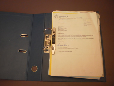
Blue folder containing documents about the master plan of the schools 2000 construction and its approval -
 Bendigo Historical Society Inc.
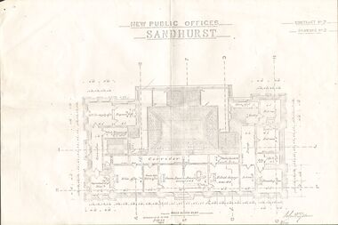
Plan - NEW PUBLIC OFFICES SANDHURST
Photocopy of Plan for New Public Offices Sandhurst 1883-1887 - Drawing No3/Contract No2bendigo, planning, sandhurst -
 Bendigo Historical Society Inc.
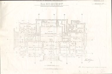
Document - NEW PUBLIC OFFICES SANDHURST
Photocopy of Plan for New Public Offices Sandhurst 1883-1887 - Drawing No2/Contract No2bendigo, planning, sandhurst -
 Bendigo Historical Society Inc.
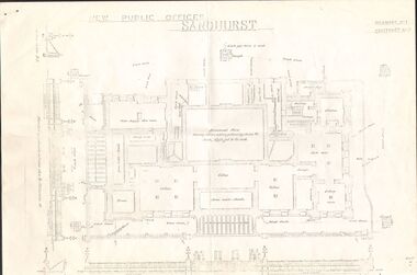
Document - NEW PUBLIC OFFICES SANDHURST
Photocopy of Plan for New Public offices Sandhurst 1883-1887 - Drawing No1/Contract No2bendigo, planning, sandhurst -
Kew Historical Society Inc
Archive (Sub-series) - Subject File, Kew Historical Society, Girl Guides, 1958
Various partiesReference, Research, InformationSecondary Values (KHS Imposed Order)Subject file containing planned events for girl guides in 1971, written by Sandra Macellan, Commissioner.kew historical society - archives, girl guides - kew (vic)kew historical society - archives, girl guides - kew (vic) -
University of Melbourne, Burnley Campus Archives
Plan, Plant Culture and Garden Maintenance Planting Plan Assignment, 1988
Tracing paper copy of plan of area with Tennis Court, to be removed. Signed MG?, July 1988.tennis court, burnley -
University of Melbourne, Burnley Campus Archives
Plan, Horticultural Project Conservation and Management Plan Wombat Park, c. 1990
Photocopies of plan drawn by M. Gilbert of Survey Area C-G, with numbered plant list.m. gilbert, wombat park, management plan -
University of Melbourne, Burnley Campus Archives
Plan (Item), Gibson North Island Bed 1:50 Nov. '17, 2017 - 2019
-
University of Melbourne, Burnley Campus Archives
Plan (Item), Burnley Campus School of Ecosystem and Forest Sciences
university of melbourne, burnley campus, property & buildings -
University of Melbourne, Burnley Campus Archives
Plan, 68-70 Dorcas St South Melbourne, 1989
Site/Roof plan by David Earle & Associates, Project No 1189 Drawing No A1. Designed by D.F.david earle -
University of Melbourne, Burnley Campus Archives
Plan, Planting Plan Contemporary Garden, c. 1990
Tracing paper and paper copies Planting Plan. Scale 1:100. Possibly student workplanting, gardens -
University of Melbourne, Burnley Campus Archives
Plan, Landscape Construction, 1960-1990
Miscellaneous plans on tracing paper and paper related mainly to Landscape Construction (approx. 40 sheets)landscape construction -
University of Melbourne, Burnley Campus Archives
Plan, Power Tool Practical, 1980-1990
Tracing paper and paper copies of plan of where to put bolts and nails in a piece of construction work.tools, construction -
University of Melbourne, Burnley Campus Archives
Plan, Landscape Concept Plan Arboriculture & Amenity Building Courtyard and Entrance, 1995
Photocopy of plan by ACM Landscape Architecture for VCAH Burnley, Vic. November 1995 Dwg L2.vcah, burnley campus -
University of Melbourne, Burnley Campus Archives
Plan, Geoff Olive, Geoff Olive Notes, 16.05.2015
site plan, campus plan, geoff olive, history -
Canterbury History Group
Pamphlet - "Hazeldene" - Auction, 1996
Real Estate Advertisement for the auction of "Hazeldene" Saturday 7th December 1991. Includes floor plancanterbury, balwyn road, fletcher & parker, "hazeldene" -
Canterbury History Group
Ephemera - A stroll to Maling village, {2000]
Real estate advertisement for the sale of 26 Milton Street Canterbury.Includes a sketch of the house and a floor plancanterbury, milton street -
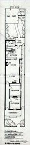 Hawthorn Historical Society
Drawing - Floorplan, 10 Aberdeen Street, Hawthorn, 1989
'After training as a Cartographic Draftsman within the mining industry, I worked as a property illustrator for real estate firms in the eastern suburbs of Melbourne for 23 years from 1983. I initially photographed houses with a Polaroid camera and made a 'thumbnail' sketch while there. The photos were used to scale off a sketch in pencil and then that sketch was overlaid with drafting film and the 'pen and ink' completed. The pens I used were the Rotring ‘Rapidigraph’ drafting pens. The ink was also made by Rotring (German).The film was ‘Rapidraw’, polyester drafting film, double matte. It takes a very fine line and doesn’t bleed. As well as house sketches, there were often floor plans and site plans ordered. Aerial sketches were ordered when the property needed an overall view.' (Margaret Picken, 2020)This property illustration is one of a series created by Margaret Picken for a range of real estate agents in Melbourne between c. 1983 and c. 2006. Each work is signed and dated by the artist.Gift of Margaret Picken, 2020Pen and ink floor-plan on drafting film of 10 Aberdeen Street, Hawthorn by Margaret Picken.Floorplan - 10 Aberdeen Street Hawthorn Margaret Pickenartist - margaret picken 1950-, 10 aberdeen street hawthorn, floorplan -
 Melbourne Tram Museum
Document - Report, McCarty Underwood & Co, "Proposed Melbourne to Burwood Electric Tramway", May 1914
The report titled "Proposed Melbourne to Burwood Electric Tramway and Electrification of Hawthorn Horse Tramway" by McCarty Underwood dated May 1914. Report prepared as a precursor to the formation of the Hawthorn Tramways Trust. The report looks at the estimated costs, revenue, expenditure and engineering difficulties. Only considered a line to Burwood, not Wattle Park. Has a page looking at the use of Storage Battery cars. Yields information about the establishment of the Burwood tram line.Report - 16 printed foolscap sheets plus a fold out plan in colour, centre stapled.Has "1" in a circle in indelible pencil in the top right hand corner.tramways, tramcars, htt, burwood, report, battery trams -
Federation University Historical Collection
Document, Graeme Tyrrell, Overview for the Development of Gardens Lydiard Street Campus, 1988, 01/12/1988
The report was prepared by Graeme Tyrrell, headgroundsman/Gardener at the Ballarat School of Mines (SMB) for Bob Feary, Manager of Facilities at SMB. The report was designed to present a broad cover of current plans for specific sites at the Lydiard Street campus.Seven page report on the development of the Ballarat School of Mines Gardens, including the Motor Mechanics Portable, Hickman Street (now demolished); Recreation Building (now demolished), E.P.U.Y Building, Hickman Street, vacant block behind creche (now site of UBTec building); Creche, Grant Street (now demolished); Former Courthouse building, Grant Street terrace, Brick Court yard, conifer beds lining Lydiard Street, Herb Garden above M.B. John Building, Terrraced area above Ballarat School of Mines Botanical Garden (referred to as Von Mueller garden). The report includes a campus plan. The report is copied onto white paper and is stapled at the top left corner. ballarat school of mines botanical gardens, ballarat school of mines, bob feary, graeme tyrrell, gardens, ballarat school of mines campus, smb campus -
 Kew Historical Society Inc
Plan - Subdivision Plan, Jas R Mathers Son & McMillan, East Kew Tramway Estate, 1915
Pru Sanderson, in her groundbreaking ‘City of Kew Urban Conservation Study : Volume 2 - Development History’ (1988), summarised the periods of urban development and subdivisions of land in Kew. The periods that she identified included 1845-1880, 1880-1893, 1893-1921, 1921-1933, 1933-1943, and Post-War Development. These periods were selected as they represented periods of rapid growth or decline in urban development. An obvious starting point for Sanderson’s groupings involved population growth and the associated economic cycles. These cycles also highlighted urban expansion onto land that was predominantly rural, although in other cases it represented the decline and breakup of large estates. A number of the plans in the Kew Historical Society’s collection can also be found in other collections, such as those of the State Library of Victoria and the Boroondara Library Service. A number are however unique to the collection.The Kew Historical Society collection includes almost 100 subdivision plans pertaining to suburbs of the City of Melbourne. Most of these are of Kew, Kew East or Studley Park, although a smaller number are plans of Camberwell, Deepdene, Balwyn and Hawthorn. It is believed that the majority of the plans were gifted to the Society by persons connected with the real estate firm - J. R. Mathers and McMillan, 136 Cotham Road, Kew. The Plans in the collection are rarely in pristine form, being working plans on which the agent would write notes and record lots sold and the prices of these. The subdivision plans are historically significant examples of the growth of urban Melbourne from the beginning of the 20th Century up until the 1980s. A number of the plans are double-sided and often include a photograph on the reverse. A number of the latter are by noted photographers such as J.E. Barnes.The East Kew Tramway Estate was a subdivision of two separate parcels of land between Adeney Avenue and Normanby Road. The larger section included 54 lots facing Adeney Avenue, Argyle Road, and Campbell, Hunter and Wishart Streets. [Hunter and Wishart Streets were created as part of the subdivision.] A further 17 allotments faced Normanby Road, Hubert and Campbell Streets. [The name of Hubert Street was later to be changed to Cecil Street.] The promotion of the sale referred to the advantages of living between two tram routes, in High Street and Cotham Road. On the plan, quaintly drawn trams mark these routes. Also on the plan is the route of part of the Outer Circle [Railway] Line.east kew tramway estate, subdivision plans - east kew -
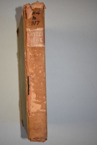 Warrnambool and District Historical Society Inc.
Letter book 6, Jan 1914 - 1917, 1914
This letter book contains letters, plans and sketch maps dating from 1914 to 1917. It came from the office of John William Crawley Junior, an engineer, architect and surveyor in private practice in Warrnambool and also the engineer for the Shire of Warrnambool from 1895 to 1935. His father, brother and son were also engineers and worked in that capacity or as the Shire Secretary for the Shire of Warrnambool, with the Crawley family recording a total of 132 years of service to the Shire of Warrnambool. This Shire existed from 1863 to 1994. The letter book was passed on the John Crawley’s son, Rolf, engineer for the Shire of Warrnambool from 1935 to 1968. It then came into the possession of Michael Hand who took over the private surveying practice of Rolf Crawley in Warrnambool. The Warrnambool and District Historical Society has acquired the letter book, along with several other Crawley ledgers, from the Michael Hand estate. This letter book is of considerable significance as it contains letters, maps and plans drawn up by John William Crawley, Junior, the engineer for the Shire of Warrnambool for 40 years. It will be very useful for researchers. This is a brown hard cover letter book with leather binding on the edges of the cover and on the spine. The leather is worn away in several places. There is gold lettering on the spine. The book has 750 pages of handwritten letters, maps and plans. The inside cover is of a mottled blue colour. There is an alphabetical index at the beginning of the book. ‘6’ ‘Letter Book 1914 to 1917’ john william crawley junior, warrnambool, rolf crawley, warrnambool, shire of warrnambool -
 Orbost & District Historical Society
folder, Orbost Bridges - Snowy River Road Bridges, 1974 1976
This folder was compiled in October 2015 from documents, magazines. papers and photographs donated by David Jellie, engineer in charge 1974 - 1976. In early 1974, as an Engineer with the Country Roads Board, David came to Orbost as the Supervising Engineer for the construction of the new bridges which were part of an 8.4km Orbost bypass road design. This was a major project involving not only a new bridge over the Snowy River (including Lochiel Lagoon), but other bridges over Ashby’s Gulch and Watt’s Gulch. These new bridges were opened in November 1976 with the unveiling of a plaque on the eastern end of the $2.4M Snowy River Bridge. (ref. May Leatch)This item is a useful reference tool on the construction history of the Snowy River Road bridges.A white plastic folder - Orbost Bridges - Snowy River Road Bridges. it contains newspaper articles, booklets, photographs and documents relating to the construction of the Snowy River Road Bridge in 1974 -1976.on front cover - 1974 - 76 ORBOST / SNOWY RIVER ROAD BRIDGES * construction * photos * articles * plans Donated by David Jellie Oct 2015snowy-river-bridges jellie-david -
 Rutherglen Historical Society
Map, 1908
This is a map produced as part of a book entitled.. It is also stamped on the back in blue ink with an oval ring and the words North of England Institute. Newcastle. Mining & Meterolgical Faculty. Purchased on 23rd July 2017 by the Society after research by member Simon Killeen. Mining map of one of the first mines in Rutherglen area ( Chiltern West)Cream paper, black printing, rectangle with a drawingGeographical Survey of Victoria, Memoir, No6. Plate XX Plan of Underground Workings CHILTERN VALLEY CONSOLS MINE, RUTHERGLEN, PARISH OF CHILTERN WESTgold, rutherglen, mining, chiltern, underground mine map, geological survey, reef drives -
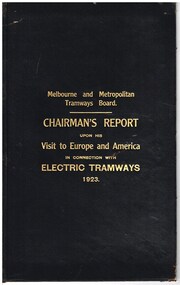 Melbourne Tram Museum
Document - Report, Melbourne & Metropolitan Tramways Board (MMTB), "Chairman's Report upon his Visit to Europe and America in connection with Electric Tramways 1923", 1924
Report - black Rexene cloth card covers, 28 pages (including blank end and glued papers), sewn binding one section titled "Chairman's Report upon his Visit to Europe and America in connection with Electric Tramways 1923". Title gold blocked. Details Alex Cameron's 1923 visit to America, Great Britain and the Continent of Europe in connection (note different spelling to the cover) with electric tramways. In particular it was to investigate the question of the use of Conduit systems. Visited San Francisco, Los Angeles, Kansas City, St Louis, Chicago, Detroit, Cleveland, New York and Washington. Then to London, Paris, Brussels. Also attended the Municipal Tramways Association conference held in Portsmouth, August 1923. His conclusions - conduit system not desirable, and the need to regulate buses from competition with tramways. Has an appendix extracts of numerous reports, letters and papers about the various issues. Report dated 29th Oct. 1924. Second copy from the McComb collection added 5-1-2017 - scanned to a pdf - text readable when opened in Adobe format.Has a lable on the first page, "Plan & EPA Library M0036390" Second copy - has Mr. Lormer in the top left and right hand comers.trams, tramways, trams, tramways, mmtb, conduit systems, tramways, conversion, electrification, europe, usa -
Bendigo Historical Society Inc.
Document - MCCOLL, RANKIN AND STANISTREET COLLECTION: H. J. LEEDS - VALUATION NOTES, 1949
Booklets: made from school graph paper exercise books cut in half. Contents - notes and property plans for loan applications and property sales, also progress payment reports, No 3 has copies of ' Home Purchase Plan' Valuation reports attached.MCCOLL RANKIN AND STANISTREETorganization, business, property, mccoll rankin and stanistreet -
 Bendigo Historical Society Inc.
Book - CONSERVATION PLAN OF THE BENDIGO PRISON COMPLEX, 1996
This conservation plan provides a detailed analysis of the significance of the Bendigo Prison complex and concludes with a recommended policy for the maintenance of the significance of the site. Report prepared by Bryce Raworth Conservation Consultant Architectural Historian in association with RBA Architects Conservation Consultants. Containing photographs and plans.Bryce Raworthbendigo, buildings, prison, bendigo prison, heritage buildings, bendigo history, conservation heritage buildings, . -
 Whitehorse Historical Society Inc.
Report, A Report on the Development of Yarran Dheran, 1/05/1985 12:00:00 AM
Report by a landscape designer, Paul Thompson, on Yarran Dheran as it was in 1985 and its development in terms of the 1974 master plan. Various areas are discussed in detail. Also includes a summary of the Master Plan. Lists of weeds. Recommendations of appropriate plants for various zones. 22p.yarran dheran, native plants, weeds, parks and reserves -
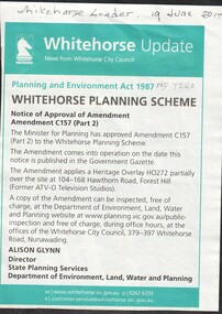 Whitehorse Historical Society Inc.
Article, Heritage Overlay - Formal ATV-0, 2017
The Minister for Planning has approved amendment C157 (Part 2) to the Whitehorse Planning Scheme which applies a Heritage Overlay HO 272 partially over the site at 104 -168 Hawthorn Road, Forest Hill (Former ATV 0 Television Studios)heritage overlay, city of whitehorse, hawthorn road, forest hill no. 104 -168, television stations, channel 0 tv studios