Showing 3762 items
matching surveyed
-
 Kew Historical Society Inc
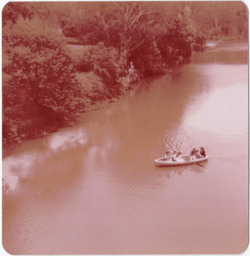
Photograph - Historic re-enactment during the Festival of Kew, 1978
At the 1978 Festival of Kew, a number of organisations, including the City of Kew, the Kew Historical Society, Trinity Boys Grammar School and local Girl Guides participated in a re-enactment of the expedition of the party of Charles Grimes in surveying the Yarra River as far as Kew in February 1803. The location for the event was Yarra Bend Park near the Studley Park Boat House. The event was organised by the Kew Historical Society. The re-enactment was captured by a number of amateur photographers as well as by a photographer from the local Progress Press.Local communities select events to commemorate according to their shared history and values. Commemorations of colonial exploration were popular with local historical groups such as the Kew Historical Society in the twentieth century. In re-enacting events such as the Grimes survey of the Yarra, students from a local school were encouraged to take on specific roles, including play-acting individuals involved in the survey party as well as members of the local Wurundjeri People. The photographs, taken by amateur and professional photographers, represent a period in time when the dominant values were those shared by the descendants of European settlers in Victoria. Original colour photographic positive of six students from Trinity Grammar School, dressed in period costume, enacting in 1978 the arrival of the surveyor Charles Grimes at Studley Park in 1803. Annotated on reverse: "BOAT CREW / TRINITY BOYS AS GRIMES PARTY / 1978"kew historical society, trinity grammar school, kew girl guides, city of kew, yarra river, charles grimes, collins expedition, wurundjeri people, yarra bend park, colonial surveys, historic re-enactments, festival of kew, kew festival -
 Kew Historical Society Inc
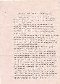
Map, Robert Russell, Map Shewing the Site of Melbourne and the Position of the Huts & Buildings Previous to the Foundation of the Township by Sir Richard Bourke in 1837
Map shows the first layout of Melbourne by Government surveyor Robert Russell, who accompanied Governor Richard Bourke in 1837. The surveyed blocks extend from present-day Flinders Street to Lonsdale Street, and Spring Street to Spencer Street, with extensive vacant land west to a salt lake (afterwards Batman's Swamp, later drained), north beyond Flagstaff Hill and south towards South Melbourne. Vegetation coverage is indicated, and tracks and existing buildings and cultivated land are shown.Printed map was created by Day & Haghe, Lithographers to the Queen, sometime after 1838, when the company received its Royal appointment. Copies of the 1837 map exist in several major map collections in Australia; most are uncoloured. This particular map is the earliest in the Kew Historical Society's map collection. It is a nationally significant artefact. Black and white lithographed map hand-coloured in blue and yellow gouache of the town of Melbourne in 1837. In contrast to the original lithograph, the river and the township blocks are coloured blue and yellow. A similar, partly coloured copy is in the collection of the University of Melbourne.maps - melbourne - 1830s, governor sir richard bourke, robert russell - surveyor, cartography -
 Whittlesea Historical Society Inc.
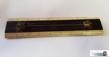
Instrument - Lockwood's Parallel Rule, Ebony and ivory, 19th Century
Ebony and ivory parallel rule with scale markings used by William Henry Lockwood. William Lockwood was born in 1832 in Glossop, Derbyshire and came to Victoria in 1853 on the 'Marco Polo'. He settled in Whittlesea with his wife Naomi in 1856. He was contracted to the Whittlesea Road Board and was the Engineer to the Shire for a period of 40 years. Some instruments have markings 'JL' on them which is presumed to be Joseph Lockwood, William Henry Lockwood's father. There are 10 items in the Lockwood Surveying and Drafting Instruments Collection.Lockwood's rectangular ebony and ivory parallel rule with bevelled edges and score markings to 9 inches.ebony, ivory, ivory rule, william henry lockwood, surveying instrument, drafting instrument, roads board, parallel rule, engineering, whittlesea, 1856, lockwood collection -
 Whittlesea Historical Society Inc.
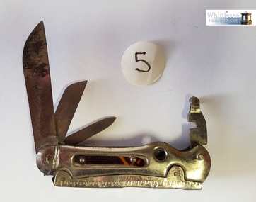
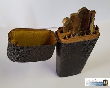
Equipment - Lockwood's pocket knife, 19th Century
3 blade retractable pocket knife used by William Henry Lockwood. William Lockwood was born in 1832 in Glossop, Derbyshire and came to Victoria in 1853 on the 'Marco Polo'. He settled in Whittlesea with his wife Naomi in 1856. He was contracted to the Whittlesea Road Board and was the Engineer to the Shire for a period of 40 years. Some instruments have markings 'JL' on them which is presumed to be Joseph Lockwood, William Henry Lockwood's father. There are 10 items in the Lockwood Surveying and Drafting Instruments Collection.19th century surveying and drafting instruments used by William Henry Lockwood, Engineer of Whittlesea, Victoria, Australia.Lockwood's stainless steel 3 blade pocket knife with tortoise shell inlaypocket knife, william henry lockwood, whittlesea, engineer, 1856 -
 Whittlesea Historical Society Inc.
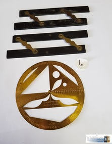
Instrument - Lockwood's Brass Protractor 360 degrees, 1886
Brass protractor 360 degrees used by William Henry Lockwood. William Lockwood was born in 1832 in Glossop, Derbyshire and came to Victoria in 1853 on the 'Marco Polo'. He settled in Whittlesea with his wife Naomi in 1856. He was contracted to the Whittlesea Road Board and was the Engineer to the Shire for a period of 40 years. Some instruments have markings 'JL' on them which is presumed to be Joseph Lockwood, William Henry Lockwood's father. There are 10 items in the Lockwood Surveying and Drafting Instruments Collection.Lockwood circular brass protractor 360 degrees, and 2 x ebony and brass parallel rulePolygraph Co. Phila. Pat. Dec. 8th 1885 - 3. Sole licensee for Europe. G.D. London. England. Improvements pat' in Europe Dec-1886brass protractor, william henry lockwood, drafting instrument, surveying instrument, ebony rule, engineer, whittlesea, 360 degree protractor -
 Whittlesea Historical Society Inc.
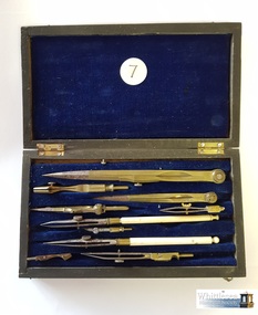
Instrument - Lockwood's boxed drawing set for ink work, 19th Century
Boxed drawing set for ink work used by William Henry Lockwood. William Lockwood was born in 1832 in Glossop, Derbyshire and came to Victoria in 1853 on the 'Marco Polo'. He settled in Whittlesea with his wife Naomi in 1856. He was contracted to the Whittlesea Road Board and was the Engineer to the Shire for a period of 40 years. Some instruments have markings 'JL' on them which is presumed to be Joseph Lockwood, William Henry Lockwood's father. There are 10 items in the Lockwood Surveying and Drafting Instruments Collection.19th century surveying and drafting instruments used by William Henry Lockwood, Engineer of Whittlesea, Victoria, Australia.Lockwood's boxed drawing set for ink work, mahogany coloured rectangular wooden box with hinged lid, small rectangular brass plate on top, brass hook clasps and hinge closure, box is lined with blue fabric, recessed slots on inside for the 10 various drawing instrument pieces.william henry lockwood, drawing set, drafting instrument, surveying instrument, whittlesea road board, whittlesea engineer, 1856, ink work -
 Whittlesea Historical Society Inc.
Instrument - Lockwood's drawing set with parallel rules, 19th Century
Drawing set with parallel rules used by William Henry Lockwood. William Lockwood was born in 1832 in Glossop, Derbyshire and came to Victoria in 1853 on the 'Marco Polo'. He settled in Whittlesea with his wife Naomi in 1856. He was contracted to the Whittlesea Road Board and was the Engineer to the Shire for a period of 40 years. Some instruments have markings 'JL' on them which is presumed to be Joseph Lockwood, William Henry Lockwood's father. There are 10 items in the Lockwood Surveying and Drafting Instruments Collection.19th century surveying and drafting instruments used by William Henry Lockwood, Engineer of Whittlesea, Victoria, Australia.Lockwood's boxed drawing set, with brass hinged lid, inside of the box is divided into 10 compartments containing, parallel rules (ebony), compasses, protractor, ruler with inclination scales.william henry lockwood, drafting instrument, drawing set, surveying instrument, whittlesea road board, whittlesea, 1856 -
 Whittlesea Historical Society Inc.
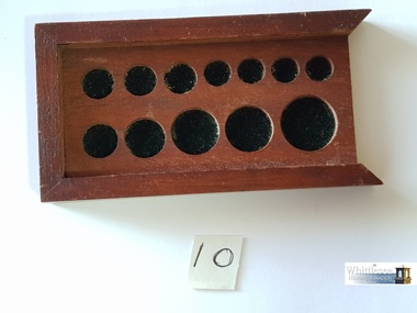
Equipment - Lockwood's box base, 19th Century
A box base, use unknown, used by William Henry Lockwood. William Lockwood was born in 1832 in Glossop, Derbyshire and came to Victoria in 1853 on the 'Marco Polo'. He settled in Whittlesea with his wife Naomi in 1856. He was contracted to the Whittlesea Road Board and was the Engineer to the Shire for a period of 40 years. Some instruments have markings 'JL' on them which is presumed to be Joseph Lockwood, William Henry Lockwood's father. There are 10 items in the Lockwood Surveying and Drafting Instruments Collection.Lockwood's wooden box base of 12 circular recesses, use not confirmedbox base, william henry lockwood, surveying instrument, whittlesea roads board, engineering, 1856 -
 Whittlesea Historical Society Inc.
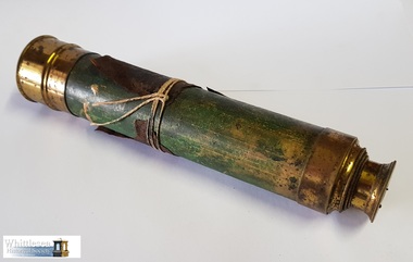
Instrument - Lockwood's Telescope, telescope, 19th Century
This telescope was used by William Henry Lockwood, local Whittlesea Engineer and Post Master. William Lockwood was born in 1832 in Glossop, Derbyshire and came to Victoria in 1853 on the 'Marco Polo'. He settled in Whittlesea with his wife Naomi in 1856. He was contracted to the Whittlesea Road Board and was the Engineer to the Shire for a period of 40 years. Some instruments have markings 'JL' on them which is presumed to be Joseph Lockwood, William's father. There are 10 engineers surveying instruments in the Lockwood collection.19th century surveying and drafting instruments used by William Henry Lockwood, Engineer of Whittlesea, Victoria, Australia.Brass telescope with 1 draw tube, glass eyepiece, 1 brass eyepiece cover, thin scrap of brown leather attached to the barrel and secured with string.telescope, william henry lockwood, engineer, surveying equipment, lockwood collection, whittlesea roads board, 1856 -
 Bendigo Historical Society Inc.
Document - Fortuna Villa - The Past and the Future
Theodore Batterstedt and his father bought five acres of land on which they built a quartz crushing mill and a two storied, 8 roomed home in 1855. In 1869 they added 2 large rooms to each floor. In 1870 they sold the property to George Lansell. Further additions and renovations too place in 1888' 1890, 1900 and 1907. In 1942 the largely derelict building was compulsorily acquired by the army to house the Land Headquarters Cartographic Company and later the Army Survey Regiment.A 2 page document detailing the history of George Lansell's 'Fortuna' estate.george lansell, fortuna, military -
 Bendigo Historical Society Inc.
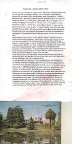
Document - RESEARCH PAPERS: THOMAS WILKINSON PINNIGER, 1828
Thomas Pinniger (1828-1927) was born in England and emigrated to New Zealand before coming to Australia in 1852. With a team of 4 he conducted the first geodetic* survey of Victoria. He became the Government Surveyor for Bendigo in 1853 and in 1854 he laid out the plans for the town of Broadford. His son George, became the Victorian Surveyor General 1925-6. * Large scale mapping based on global measurements of large land masses. It allows corrections for the curvature of the earth.Document detailing the history of district serveyor Thomas Wilkinson Pinniger and his family history. -
 Bendigo Military Museum
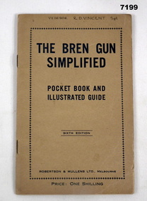
Manual - OPERATIONAL MANUAL
Manuals supplied for training and for maintenance in relation to use and upkeep of the Bren Gun. Robert Duncan Vincent enlisted initially as V11896 in the CMF on 17.3.1941, attached to AHQ Cartographic Coy as a Draughtsman 18.3.1941, Cpl 2.6.1941, Sgt 24.10.1941, transfer to the AIF as VX116906 on 3.12.1942, detached to Survey LHQ Bendigo, transfer to HQ BCOF 2.2.1946, emplane for Morotai 5.2.1946, embark for Kure Japan 7.3.1946, return to Australia 5.11.1946, discharged from the AIF 11.11.1946, rank Sgt in HQ BCOF.Small yellow/brown manual for the operation of the Bren Gun. Writing on cover and inside all in black and some illustrations. Centre page folding out to three standard pages with image of full gun and mount with individual parts identified. 12 pages inside.Written on front "VX116906 R.D. Vincent SGT" Titled "The Bren Gun Simplified" - price One Shilling.bren gun, training -
 University of Melbourne, Burnley Campus Archives
Plan, S. Subari, Footscray Park Existing Conditions, 1987-1991
Plans by the City Engineer, City of Footscray File No 4329 drawn by S. Subari 25/9/1987. Scale 1:1000. (1) Sheet 1 of 2, 1 full plan with plant legend for trees by letter, 2 sections of plan enlarged with numbering for "Other Trees," different numbering on each. (2) Sheet 2 of 2, full plan with plant legend for trees by letter. (3) Footscray Park: Key to Tree Species. (4) 2 copies handwritten notes by John Hawker, 1 set numbered. Plant survey January 1991.footscray park, s. subari -
Clunes Museum
Document (item) - CERTIFICATE, SUPREME COURT OF VICTORIA, WILLIAM AND SARAH STEART
william steart, sarah jane steart, henry harold steart -
 Bendigo Military Museum
Photograph - Hockey Team - Army Survey Regiment, Fortuna, Bendigo, c1988 to 1990
This photograph of Fortuna’s Hockey Team was taken at the Bendigo Regional Hockey Complex, Garden Gully, Ironbark, a suburb of Bendigo circa 1988 to 1990. It is possible this photo was most likely taken at an inter-area Army competition or alternatively, an inter-service or local Bendigo competition.This photograph of Fortuna’s Hockey Team was taken at the Bendigo Regional Hockey Complex, Garden Gully, Ironbark, a suburb of Bendigo circa 1988 to 1990. The photograph was printed on photographic paper and is part of the Army Survey Regiment’s Collection. The photograph was scanned at 300 dpi. .1) - Photo, colour, c1988 to 1990. Back row L to R: Peter Imeson, Trevor Osborne, Andy Love, Peter Lefel, unidentified, Graeme Spong, Nadine Paul, Stuart Thaxter. Front row L to R: Nick Cowan, unidentified, John Reid, unidentified, Dick Crawford.No personnel are annotated.royal australian survey corps, rasvy, army survey regiment, army svy regt, fortuna, asr -
 Melbourne Tram Museum
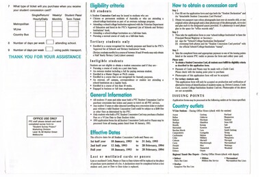
Document - Form, Public Transport Corporation (PTC), "Student Concession form", 1993
1051 - Form - DL size, printed on off white paper, two colours, three fold giving details of student passes for Melbourne Metro area, regional transit student passes, eligibility criteria, how to obtain a concession card, conditions for use, a survey form. Partly filled in with some details - 9/1993. 1051.1 - Form DL - 5 fold, similar to above, dated 2001. See also Reg Item 5513 for another example. .3 - 6 fold DL with tear off application form for Myki use - dated 2007.trams, tramways, concession fares, students, tickets, passes, the met, ptc, myki -
 Bendigo Historical Society Inc.
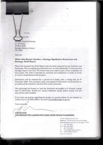
Document - WHITE HILLS BOTANIC GARDENS, BENDIGO: HERITAGE SIGNIFICANCE ASSESSMENT AND STRATEGY PROJECT
Four hundred and forty three page report titled 'White Hills Botanic Gardens, Bendigo - Heritage Significance Assessment and Strategy Project by Lee Andrews & Associates Heritage Consulting, dated 31 October 2006. Contains History of White Hills Botanic Gardens, Physical Survey ad Analysis, Comparative Analysis, Analysis and Assessment of Cultural Significance, Developing the Conservation Policy, Conservation Policy, Conservation Guidelines, Conservation Actions,References and Appendices. Also contains a number of photos, copies of plans and documents, and a plan of the area with the trees marked and identified.document, white hills botanic gardens bendigo - heritage significance assessment and strategy project, bendigo historical society, jim evans, tim buykx, greater bendigo city council, lee andrews & associates heritage consulting, bendigo advertiser, the bendigonian, bendigo independent, argus, bendigo homes and property, mal gregory, mitch kemp, anthony sheean, casey ely, vicki johnson, sandra crump, friends of bendigo's botanic gardens, jane cleary, judy milner, jan orr, heritage victoria, john hawker, department of sustainability and environment historic places, norm stimson, bill dundas, janette hodgson, royal botanic gardens melbourne, roger spencer, university of melbourne burnley campus, greg moore, goldfields research centre, bendigo library, vivien newton, rita hull, state library of victoria, matheson library monash university, mueller correspondence project, sara maroske, library of the royal botanic gardens melbourne jill thurlow, helen cohn, gwen pascoe, john dwyer, larritt and russell -
Bendigo Historical Society Inc.
Document - MARKS COLLECTION: PLAN OF SANDHURST CITY CENTRE AND SURROUNDING AREA ( NO. 1 )
Plan on heavy parchment - section neatly cut out of plan (area now Kennington) Written on plan in black print ' Sheet No. 1. Sandhurst'. Plan shows Government Camp, Commissioner's Gully, old cemetery site, manure depot, cattle market, Benevolent Asylum Reserve, railway reserve. Land owners' names on allotments. On bottom lithographed at the Department of Lands and Survey, Melbourne, by D. Henerson, March 12th., 1867 Plan part of George Lansell, Fortuna auction, documents found in wardrobe purchased by Marks family in 1930's.bendigo, planning, sandhurst 1867 -
 Bendigo Historical Society Inc.
Document - CAROL HOLSWORTH COLLECTION: GEOLOGICAL REPORT BENDIGO GOLDFIELD
Four page document, an extract from the Geological Report on the Bendigo Goldfield. On front page, a line drawing of a puddling machine. Contents include: alluvial mining, reef mining, the boom years, deep sinking, decline of mining, modern exploration, physiography, the hills, the valleys and the soils. A table demonstrates the development of graptolite structures, including the Lancefieldian, Bendigonian, Chewtonian and Castlemainian graptolite species. Two diagrams demonstrate saddle and bedded reefs and fault reefs. Written on top of the document: C.E. William and H.E. Wilkinson, 1992. Geological Survey Report No. 93.bendigo, mining, geological bulletin 93 -
 Bendigo Historical Society Inc.
Document - NORMAN OLIVER COLLECTION: MAYOR SPEAKS 9 APR 1965
The Norman Oliver collection. Norman Oliver was three times Mayor of Bendigo - 1950-51, 1964-65, 1970-71. Two typed pages, the second also has typed notes on the reverse. There are two ink splotches on the front page. The document is titled 'The Mayor Speaks' and dated 9/4/65 in blue ink. The top half of the first page is over-typed and difficult to read. Topics include : the Australian Survey Regiment and conferring of medals, problems with council-funded works and financing, Sandhurst Boys Centre, and the Anti Cancer Appeal.bendigo, council, report, norman joseph oliver , councillor norman oliver. mayor of bendigo. -
 Kiewa Valley Historical Society
Set of 4 photographs of SECV Clerical staff, 1940 - 1941
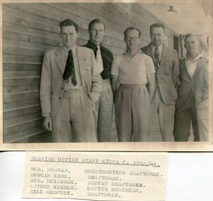
The Kiewa Hydroelectric Scheme is the largest hydro-electric scheme in Victoria and the second largest in mainland Australia after the Snowy Mountains Scheme. The scheme is situated in the Australian Alps in north-eastern Victoria about 350 km from Melbourne and is wholly owned by AGL Energy. The scheme was originally constructed between 1938 and 1961 by the State Electricity Commission of Victoria although it was privatised in the 1990s. The scheme was originally developed solely for electricity generation, unlike the Snowy Mountains Scheme, which was also intended to direct water west of the Snowy Mountains for purposes of irrigation. From 1937 to 1944 the construction of dams at Pretty Valley, Rocky Valley and the Junction Dam were undertaken requiring large numbers of planning and support staff to see the projects successfully completed. Planning and support staff were the backbone of the successful completion of the Kiewa Valley Hydro Electric Scheme and contributed significantly to the development of the Kiewa Valley area. Many descendants of the men in the photographs still living and working in the local areaSet of 4 black and white photographs of SECV clerical staff – Circa 1940/1941Typed on note glued to back of each photo, Numbers handwritten in blue ink in top left hand corner 1. DRAWING OFFICE STAFF KIEWA C. 1940-41 Bob Morgan – Construction Draftsman; Duncan Kerr – Draftsman; Rob Hollands – Survey Draftsman; Arthur Keeble – Office Engineer; Bill Godfrey – Draftsman 2. CLERICAL OFFICE STAFF KIEWA Peter Harnetty – Clerical; Bert Connors – Clerical; John Martin – Stores Clerical; Ken Calder – Head Storekeeper; Bill black – Construction Records 3. CLERICAL OFFICE STAFF KIEWA Jack Norman, Herb Kendall, Jack Bray – Stores Clerical; Ken Calder – Head Storekeeper; Jim Swain, George Milner – Stores Clerical; Jim Gleeson – Storekeeper; John Martin – Stores Clerical 4. OFFICE STAFF KIEWA C. 1940 Don Faulkner – Cadet Engineer; Tas Davies – Survey Draftsman; Bob Morgan – Construction Darftsman; R.J. Martin, Arthur Keeble – Office Engineers; Rob Hollands – Survey Draftsman; Jack Wollard – Head Surveyor; Harry Wilson – Plan Officer. Printing Plans Handwritten in red ink on back of photo 4 – Refer Rob Hollands secv clerical staff -
Glen Eira Historical Society
Letter - MONUMENTS AND NATIONAL REGISTER
This file contains five items pertaining to plaques, memorials and monuments located in Glen Eira: 1/Three letters (1 page each) pertaining to a statue of Isabelle Webb adorning the Caulfield City Hall. The first letter, typewritten, dated 14/07/80, is addressed from J. Pollet, Honorary Secretary of the Caulfield Historical Society, to Mr. G. Calder, City Manager of Caulfield, and announces that the Society has identified the previously unidentified statue and wishes to provide a plaque for it. The second letter, handwritten, dated 20/09/1980, is addressed from Mr. R. Ballantyne of the Caulfield Historical Society to Calder, and laments that the Caulfield City Council has not responded to the first letter. The third letter, typewritten, dated 24/10/1980, is addressed from G. J. Walker, Deputy Manager-Administrator of the City of Caulfield, to Ballantyne, and notifies the latter of the Council’s acceptance of the Society’s offer to provide a plaque. Also included are the invoice and delivery docket for the plaque. 2/A typewritten letter (1 page), dated 26/06/1985, from Norma Polglase, secretary to mayor Brian Rudzki, inviting Mr. and Mrs. R. Ballantyne to an unveiling ceremony at Hopetoun Gardens. 3/A typewritten letter (1 page), dated 05/10/1986, from John Adams, Convenor of the Memorials Committee of the Royal Historical Society of Victoria, to Miss H. Bullock, thanking the latter for her contributions to the Society’s Memorials Project (which presumably consists of the recording of the location of all memorials located in Victoria), and confirming the acknowledgement of four memorials located in Caulfield. 4/A one page typewritten letter, with handwritten note, dated 07/05/1987, from Chilla Bulbeck, project coordinator of the National Register of the Australian Bicentennial Authority, to Mr. R. Ballantyne, thanking the latter for agreeing to act as a recorder for the Project. Attached are 12 pages extrapolating on the Project and a list (2 copies) of monuments thus far acknowledged, although none of this contains anything of relevance specifically to Glen Eira. 5/A typewritten letter, dated 29/11/1996, from Bob Ross, Senior Surveyor of the Geodetic Survey of the Office of the Surveyor General, to the Caulfield Historical Society, requesting the latter’s assistance in identifying any historic survey marks located within Glen Eira, as part of a greater project to identify all such survey marks located within Victoria. Also included is a leaflet extrapolating on the project and featuring a form for documenting survey marks, although this contains nothing of relevance specifically to Glen Eira.glen eira, caulfield, plaques, monuments and memorials, walker g. j., ballantyne r. mr., caulfield historical society, statues, webb isabelle, webb isabella, calder g, pollet j, city of caulfield, caulfield city council, city hall, hawthorn road, glen eira road, neville street, glenhuntly, thompson p. mr., arrow engraving & foundry co., rudzki brian j. p. cr., ballantyne mrs., cannons, festivals and celebrations, invitations, hopetoun gardens, mayors, glenhuntly road, glen huntly road, caulfield city hall, polglase norma, adams john, bullock h. miss, royal historical society of victoria, memorials committee, memorials project, ‘kadimah’, caulfield grammar school, rosstown railway, bambra park, elsternwick, begonia street, gardenvale, bulbeck chilla, australian bicentennial authority, national register of unusual monuments project, jowett memorial drinking fountain, ross bob, office of surveyor general, geodetic survey office of surveyor general -
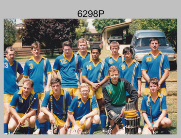
 Bendigo Military Museum
Photograph - Army Survey Regiment’s Fortuna Lions Football Club Grand Finals, Seymour, Victoria, 1983
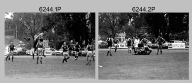
This is a set of 27 black & white photographs of Army Survey Regiment’s Australian Rules football team – the Fortuna Lions aka “Fortuna Fumblers”, taken at Seymour Victoria in 1983. The Fortuna Lions competed in the Puckapunyal Area Football Association for several years from 1978 to 1984 and in 1983, fielded a great team it managed to reach the Grand Final. Held at the neutral ground at Kings Park, Seymour, the match was an incredibly exciting and bruising contest played in damp conditions and ended in a draw. Dave Lawler’s spectacular mark was a highlight. Due to heavy rain during the following week, the Grand Final replay was held the following week in even heavier conditions. The Fortuna Lions prevailed in the replay with an emphatic victory. The team’s leaders were Eddie Jacobs (coach), Rhys De Laine (captain), Greg Else (vice-captain), and Ken Slater (manager). See item 6245.25P for colour photographs taken at the two grand finals, team photo and premiership banner with names. See item 6245.25P for colour photos of the finals, the team photo with names and a photo of the premiership banner. The team changed its name to the Fortuna Falcons and its guernsey to gold with a blue ‘V’ in 1988 and continued to compete in the competition up to 1995. This is a set of 27 black and white photographs of Army Survey Regiment’s Australian Rules football team – the Fortuna Lions aka “Fortuna Fumblers”, taken at Seymour Victoria in 1983. The photographs were printed on photographic paper and are part of the Army Survey Regiment’s Collection. The photographs were scanned at 300 dpi. Players named below are in Fitzroy jumpers. .1) - Photo, black and white. 1983. L to R: Mick Hogan, Peter Jones (ruck), Rod Skidmore (No.14), Greg Else, Stu Ridge (No.2). .2) - Photo, black and white. 1983. L to R: Rhys De Laine, Doug Home, Mick Hogan (no.12), Rod Skidmore. .3) - Photo, black and white. 1983. L to R: unidentified (x2), Keith Quinton, Doug Home, Mick Hogan. .4) - Photo, black and white. 1983. L to R: Rod Skidmore, Greg Byers, Rhys De Laine, Rhys De Laine, Jim Ash. .5) - Photo, black and white. 1983. L to R: Stu Ridge (No.2) Peter Jones (ruck No.5), Mick Hogan. .6) - Photo, black and white. 1983. L to R: Keith Quinton (No.3), unidentified (No.8), Dennis Learmonth, Greg Byers. .7) - Photo, black and white. 1983. L to R: Greg Byers, Greg Higgins, Stu Ridge, Dennis Learmonth (No.10), Keith Quinton. .8) - Photo, black and white. 1983. L to R: Bob Thrower (No.21), Peter Jones, Dennis Learmonth (No.10). .9) - Photo, black and white. 1983. L to R: all unidentified. .10) - Photo, black and white. 1983. L to R: Mick Hogan (no.12), Doug Home, Peter Jones (No.5), Greg Else, Jim Ash. .11) - Photo, black and white. 1983. L to R: Dennis Learmonth, Keith Quinton. .12) - Photo, black and white. 1983. L to R: unidentified, Eddie Jacobs (No.16), Greg Higgins (No.20). .13) - Photo, black and white. 1983. L to R: all unidentified. .14) - Photo, black and white. 1983. L to R: Rod Skidmore, Jim Ash. .15) - Photo, black and white. 1983. L to R: Greg Else (No.6), Mick Hogan (No.12), Alan Staley, unidentified. .16) - Photo, black and white. 1983. L to R: unidentified, Peter Jones, Rhys De Laine. .17) - Photo, black and white. 1983. L to R: Eddie Jacobs, Greg Else. .18) - Photo, black and white. 1983. L to R: Keith Quinton (No.3), Rod Skidmore, Eddie Jacobs, Dave Lawler. .19) - Photo, black and white. 1983. L to R: Doug Home, Greg Byers, Bob Thrower, Rod Skidmore, unidentified. .20) - Photo, black and white. 1983. L to R: Stu Ridge (No.2), Greg Higgins (No.20), unidentified (No.8). .21) - Photo, black and white. 1983. L to R: all unidentified. .22) - Photo, black and white. 1983. L to R: Peter Jones (no.5), Greg Byers (No.19), unidentified (x2). .23) - Photo, black and white. 1983. L to R: unidentified. .24) - Photo, black and white. 1983. L to R: Mick Hogan, unidentified (no.13), Rhys De Laine, Jim Ash, Keith Quinton (No.3). .25) - Photo, black and white. 1983. L to R: Steve Burke, Peter Dillon, Jim Ash, Dave Lawler, Paul Baker, Tracy Ash, unidentified, Warren Hall. In far-right background: Greg Else, Megan Reynolds. .26) - Photo, black and white. 1983. L to R: Warren Hall, Ken Slater, Cliff Webb, shirtless Glen Cannon. .27) - Photo, black and white. 1983. L to R: Warren Hall, unidentified..1P to .27P – no annotationsroyal australian survey corps, rasvy, army survey regiment, army svy regt, fortuna, asr -
 City of Moorabbin Historical Society (Operating the Box Cottage Museum)
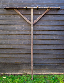
Farm Equipment, Rake, large Hay c1900, c1900
A hay rake is an agricultural rake used to collect cut hay or straw into windrows for later collection (e.g. by a baler or a loader wagon). It is also designed to fluff up the hay and turn it over so that it may dry. The next day it is spread again, so that the hay dries more quickly. Early settlers established productive market gardens, poultry,. pig and dairy farms , orchards and vineyards on the land in the 'Henry Dendy Special Survey Brighton 1841' - now Ormond, Bentleigh, East Bentleigh, Brighton, This hay rake is typical of the type used by early settlers in Moorabbin Shire c1900Large wooden Hay rake , hand made c1900farm equipment, hay rakes, hammers, early settlers, market gardeners, blacksmiths, tools, building equipment, moorabbin shire, bentleigh, mckinnon, highett, cheltenham,ormond -
 Warrnambool and District Historical Society Inc.
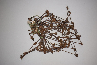
Chain link measure, Gunter, Early 20th century
This Gunter’s Chain, an old land surveying instrument, is named after its inventor, Edmund Gunter (1581-1626), an English mathematician and astronomer. It was first produced in 1620. The tool has 100 links and is 66 feet or one chain long. The links are marked off in groups of ten by metal rings or tags. A quarter chain (25 links) is called a rod or pole and ten chains make a furlong and 80 chains make a mile. The traditional cricket pitch is 22 yards or one chain long. This Gunter’s Chain is of considerable significance because: 1. It is an early land measuring tool that was used for over 250 years and has great historical and mathematical significance. A Gunter’s Chain would have been used when forming and building local roads from the earliest days of settlement. 2. It has a possible local connection as it was given to the Historical Society by a local person in 1965 and possibly came from the property of ‘Rosehill’ This is a metal tool which consists of 100 metal pieces or links joined together by loops at each end with two metal loops in between each link. The links joined together form a chain. The two ends of the chain have small metal handles attached At intervals along the chain there are additional rings or metal pieces attached. Some white and green rope material has been used to bundle up the chain. The metal is somewhat rusted. gunter’s chain, land measurement tools, history of warrnambool -
 Robin Boyd Foundation
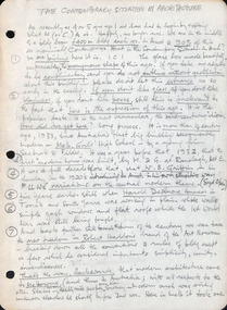
Document - Manuscript, Robin Boyd, The Contemporary Situation in Architecture
Boyd quickly surveys the first generation of modern architecture. The talk then concentrates on where modern architecture turned next: "the search for new richness on the surface and a search for new excitement in form". Boyd focuses on the second generation of modern architects: Edward Stone (surface search) and Eero Saarinen (excitiement search). Several of their influential buildings are critiqued by Boyd. This document includes the whole of the typed manuscript titled "The Crisis in Architecture" (item D522, with edits), and includes two handwritten pages at the start and ends with a handwritten statement about "architectural poetry". The text and annotations indicate this was a lecture with slides.Typewritten and handwritten sections, an amalgamation of documents, quarto, 18 pagesUnderlinings, pencil additions, indications for slidesinternational style, mies van der rohe, frank lloyd wright, edward stone, eero saarinen, le courbuier, felix candela, matthew novicki, eduardo catalano, hugh stubbins, raymond and rado, jorn utzon, toro-ferrer -
Vision Australia
Text, RVIB Wodonga Auxiliary, 1932 - 2005
The Wodonga RVIB Auxiliary formed on March 23, 1932. This small collection contains index cards which were maintained by RVIB and contain the amount of donations made by the Auxiliary between 1976 - 1995 as well as the presentations delivered by RVIB employees to Auxiliary meetings between 1978 - 1985. Correspondence to and from RVIB head office ranging between 1990 - 2005. A survey from RVIB head office in 1999 reveals the average age group of the committee and members was 70-80 years old. Includes a brief background of the Auxiliary. Letters --newspaper clippings -- index cards and various loose papers royal victorian institute for the blind -
 Bendigo Military Museum
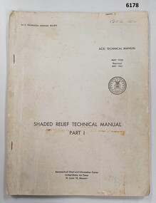
Manual - Shaded Relief Technical Manual - United States Air Force, Department of the Air Force, USA, May 1958
This manual describes how to hand create "Shaded Relief" or the appearance of hills. This manual was produced by the Aeronautical Chart Information Centre, United States Air Force, St Louis 18, Missouri. Shaded relief was produced by hand at the Army Survey Regiment in the 50's, 60's and 70's so that it could be shown on small scale topographical maps and RAAF Aeronauical Charts. Shaded relief continued to be produced by hand until the mid 1980's when it was replaced by digital production methods.Grey covered Manual, gloss paper, stapled together.royal australian survey corps, rasvy, fortuna, army survey regiment, army svy regt, asr -
 Bendigo Military Museum
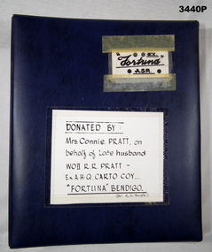
Album - Photo Album of 31074 Warrant Officer Class 2 RR Pratt RASvy, c.WWII onward
This album contains numerous items in relation to the Army Survey Regiment & WOII R R PRATT, WWII onward. Cards, drawings, magazines, souvenirs, caricatures, newspaper clippings, some photos of Bendigo Historical Society objects. Robert Richard PRATT VX85798 enlisted in the 2nd AIF on 8.8.1942 age 28 years. He was discharged from the AIF on 29.10.1947 with the rank of Sgt serving with AHQ Cartographic Coy. He then enlisted in the ARA with a Regimental Number of 31074. He was promoted WOII on 27 May 1948.Blue hard cover photo album with spiral binding. Top right side on a white label in black print: EX FORTUNA ASR In the centre on a white label in black print: Donated by Mrs Connie PRATT on behalf of late husband WOII R R PRATT Ex AHQ CARTO COY "FORTUNA" BENDIGO (Per R O Temple)royal australian survey corps, rasvy, fortuna, army survey regiment, army svy regt, asr -
 Eltham District Historical Society Inc
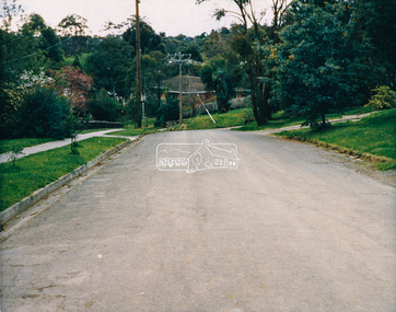
Photograph - Colour Print, Eltham Shire Council, Unidentified road, Eltham district, c.Oct. 1987
Date based on other similar display panels visible in images of the Shire of Eltham display at the Eltham Community Festival, 7 November 1987. 20 x 25 cm Shire of Eltham Engineering Department Providing the resources to undertake • Survey, design, consultation • Road construction and maintenance • Bridge construction and maintenance • Street sweeping • Drain and pit cleaning • Traffic engineering installation and maintenance • Garbage collection • Tip management, land reclamation and beautification • Maintenance of community buildings • Provision of community and recreation facilitiesunidentified, display panel, eltham festival, footpaths and gutters, infrastructure, residential, roads, shire of eltham, streets, 1987