Showing 3382 items
matching bridge road
-
 Eltham District Historical Society Inc
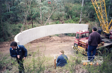
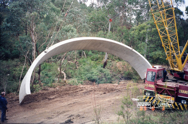
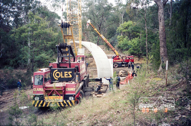
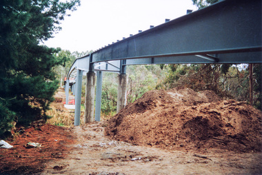
Photograph, Bridge construction over the Diamond Creek, Charlber Lane, St Andrews, 3 August 1989, 3 August 1989
Roll of 35mm colour negative film, 7 stripsKodak GA 100 5095roads, charlber lane, st andrews, bridge construction, diamond creek -
 Eltham District Historical Society Inc
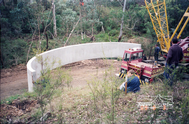
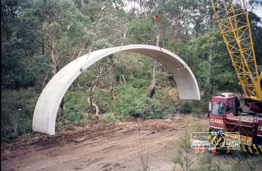
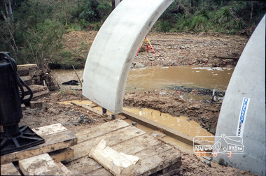
Photograph, Bridge construction over the Diamond Creek, Charlber Lane, St Andrews, 3 August 1989, 3 August 1989
Roll of 35mm colour negative film, 7 stripsKodak GA 100 5095roads, charlber lane, st andrews, bridge construction, diamond creek -
 Eltham District Historical Society Inc
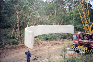
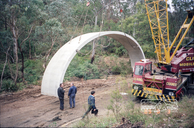
Photograph, Bridge construction over the Diamond Creek, Charlber Lane, St Andrews, 3 August 1989, 3 August 1989
Roll of 35mm colour negative film, 7 stripsKodak GA 100 5095roads, charlber lane, st andrews, bridge construction, diamond creek -
 Eltham District Historical Society Inc
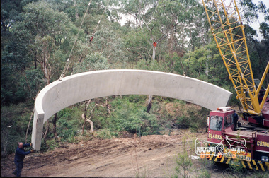
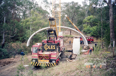
Photograph, Bridge construction over the Diamond Creek, Charlber Lane, St Andrews, 3 August 1989, 3 August 1989
Roll of 35mm colour negative film, 7 stripsKodak GA 100 5095roads, charlber lane, st andrews, bridge construction, diamond creek -
 Eltham District Historical Society Inc
Photograph, Bridge construction over the Diamond Creek, Charlber Lane, St Andrews, 3 August 1989, 3 August 1989
Roll of 35mm colour negative film, 7 stripsKodak GA 100 5095roads, charlber lane, st andrews, bridge construction, diamond creek -
 Eltham District Historical Society Inc
Photograph, Bridge construction over the Diamond Creek, Charlber Lane, St Andrews, 3 August 1989, 3 August 1989
Roll of 35mm colour negative film, 7 stripsKodak GA 100 5095roads, charlber lane, st andrews, bridge construction, diamond creek -
 Eltham District Historical Society Inc
Photograph, Bridge construction over the Diamond Creek, Charlber Lane, St Andrews, 3 August 1989, 3 August 1989
Roll of 35mm colour negative film, 7 stripsKodak GA 100 5095roads, charlber lane, st andrews, bridge construction, diamond creek -
 Eltham District Historical Society Inc
Photograph, Bridge construction over the Diamond Creek, Charlber Lane, St Andrews, 3 August 1989, 3 August 1989
Roll of 35mm colour negative film, 7 stripsKodak GA 100 5095roads, charlber lane, st andrews, bridge construction, diamond creek -
 Eltham District Historical Society Inc
Photograph, Bridge construction over the Diamond Creek, Charlber Lane, St Andrews, 3 August 1989, 3 August 1989
Roll of 35mm colour negative film, 7 stripsKodak GA 100 5095roads, charlber lane, st andrews, bridge construction, diamond creek -
 Eltham District Historical Society Inc
Photograph, Bridge construction over the Diamond Creek, Charlber Lane, St Andrews, 3 August 1989, 3 August 1989
Roll of 35mm colour negative film, 7 stripsKodak GA 100 5095roads, charlber lane, st andrews, bridge construction, diamond creek -
 Eltham District Historical Society Inc
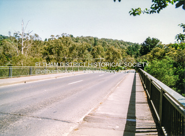
Photograph, Doug Orford, Bridge across Yarra River, Kangaroo Ground - Warrandyte Road, Warrandyte, 1991, 1991
From a collection of 35 photos taken by Doug Orford at 35 specific locations along the exact boundary of the then Shire of Eltham.Colour photographbridges, yarra river, warrandyte -
 Eltham District Historical Society Inc
Photograph, Doug Orford, Bridge works across Yarra River at rear of Eltham Lower Park, June 2004, 2004
Three colour photographs showing commencement of construction of Eltham-Templestowe footbridge over Yarra River off Homestead Road, Eltham which was completed July 2004.bridges, yarra river, eltham, eltham south, templestowe, eltham lower park, lenister farm, homestead road -
 Eltham District Historical Society Inc
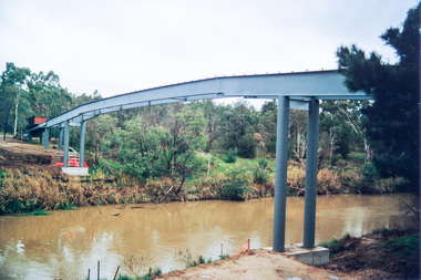
Photograph, Doug Orford, Completion of bridge works across Yarra River at rear of Eltham Lower Park, July 2004
Bitumen shared pathway under construction at the new Eltham-Templestowe footbridge over the Yarra River off Homestead Road, Eltham which was completed in July 2004. The Yarra River Footbridge was opened in August 2004 and links the Diamond Creek Trail between the Shire of Nillumbik and City of Manningham. It is a shared pathway and also links with the Main Yarra Trail. It affords lovely views over the Yarra River.Three colour photographs showing commencement of construction of Eltham-Templestowe footbridge over Yarra River off Homestead Road, Eltham which was completed July 2004. Third photograph of dedictaion plaque at opening 30 Aug 2004bridges, yarra river, eltham south, eltham lower park, lenister farm, homestead road, asphaldt, bitumen, shared pathway, diamond creek trail -
 Kiewa Valley Historical Society
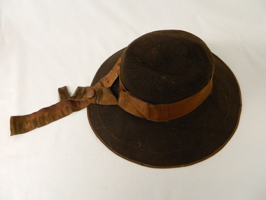
Hat Child's Felt, Circa mid 1900's
This brown wool felt hat with a broad brim was, by its style, used by a adolescent child for church services. This was worn in a period where church services on Sunday was an important weekly ritual by the whole family. Special (church only) dresses and hats were worn not only to show respect to the church but also part of expected community mores relating to religious beliefs. This behavioural pattern was more entrench in the rural communities than within larger cities. The closeness of smaller rural communities is the main factor regarding social norms. The visible standing within the community was uppermost. The period pre 2000 was a more coheasive family environment ( due to greater intra family activities) which provided better communication and family activities.This "church styled" hat is very significant to the rural lifestyle and its mores. It clearly demonstrates the coheasive force that religion has on the Valley population. The closeness that the semi isolation (at this time) brought about by the Valley's physical land formation and the poor roads within the valley brought families closer together. Not turning up for important social functionsw was duely noted by all (and frowned upon). Mrs E. Fisher lived at Mongan's Bridge in the Kiewa Valley.Brown child's all felt hat size 6 1/4. A broad brim with a lighter brown velvet ribbon head band. Head band has a crossover to the left front with 100 mm extension flowing over the brim. The top of the inside of the head pocket is lined with a soft silk fabric.6 and one quarter (size tag). Unreadable crest / monogramchildren's head wear, social head dress, church hats -
 Kiewa Valley Historical Society
Black and White photograph of Road Making Machinery, Kiewa Road Making, 25/08/1938
Construction of the main road from South Tawonga to the Bogong High Plains, to provide access to the construction sites for the new Kiewa Hydro Electric Scheme, was commenced early in 1938, the work being undertaken on behalf of the Commission by the Country Roads Board. For the construction work, the Commission purchased three Caterpillar - model R07 - diesel crawler tractors equipped with Kay Brunerei (Brunner) hydraulically operated trailbuilders (angle dozers). This acquisition resulted from a visit to the United States of America in May, 1937 by the Construction Engineer ( Mr. C.H. Kernot) and Assistant Civil Engineer (Mr. J.F. Douglas) where they saw this relatively new type of equipment in use. With the co-operation of the CRB, the Commission demonstrated the operation of these machines at Fishermen's Bend on 6th April, 1938. They were then sent to Kiewa where they commenced operation towards the end of the month. From South Tawonga, the route led immediately across the Western Branch of the Kiewa River necessitating the construction of a bridge 100 feet long. By the end of 1939, the excavation had been 'opened up' for a distance of 19 1/2 miles (approx. 31 km) and of this length, 10 miles (approx. 16 km) had been surfaced.The purchase and use of this type of mechanical equipment in road making was a huge investment, as prior to this most of the work would have been done manually with the use of picks and shovels. Not only were many months of hard manual labour saved, but a very significant amount of time in providing access to the proposed work sites for the new Kiewa Hydro Scheme. This photo is an excellent reminder of how primitive the early machinery was compared to the present but also represents the forward thinking of the State Electricity Commissions engineers in purchasing such innovative equipment . A black and white photograph showing the type of machinery used for road making in the 1930's. It shows a grader being towed by a caterpillar tractor.On the top left hand corner of the photograph , hand written in black ink is the words 'Kiewa Road Making 25/8/1938'. On the right hand side of the photo has been stamped in blue the Number 1. It has been developed on Velox paper (marked on back of photo) with a gloss finish.road making, state electricity commission, caterpillar tractor, kiewa -
 Kiewa Valley Historical Society
Black and White photograph of Road Making Machinery, Kiewa Road Making 25/08/1938 No. 2, 25/08/1938
Construction of the main road from South Tawonga to the Bogong High Plains, to provide access to the construction sites for the new Kiewa Hydro Electric Scheme, was commenced early in 1938, the work being undertaken on behalf of the commission by the Country Roads Board. For the construction work, the Commission purchased three Caterpillar - model R07 - diesel crawler tractors equipped with Kay Brunerei (Brunner) hydraulically operated trailbuilders (angle dozers). This acquisition resulted from a visit to the United States of America in May, 1937 by the Construction Engineer ( Mr. C.H. Kernot) and Assistant Civil Engineer ( Mr. J.F. Douglas) where they saw this relatively new type of equipment in use. With the co-operation of the CRB, the Commission demonstrated the operation of these machines at Fishermen's Bend on 6th April, 1938. They were then sent to Kiewa where they commenced operation towards the end of the month. From South Tawonga, the route let immediately across the Western Branch of the Kiewa River necessitating the construction of a bridge 100 feet long. By the end of 1939, the excavation had been 'opened up' for a distance of 19 1/2 miles (approx. 31 km.) and of this length, 10 miles (approx. 16 km.) had been surfaced. (see KVHS 0328)The purchase of this type of mechanical equipment in road making was a huge investment, as prior to this most of the work would have been done manually with the use of picks and shovels. Not only were many months of hard manual labour saved, but a very significant amount of time in providing access to the proposed work sites for the new Kiewa Hydro Scheme. This photo is an excellent reminder of how primitive the early machinery was compared to the present but also represents the forward thinking of the State Electricity Commissions engineers in purchasing such innovative equipment.A black and white photograph of road making near Mt. Beauty in 1938. Mount Beauty hills can be seen in the background with cleared land for grazing in the fore ground.Hand printed in black ink at the top of the photograph is 'Kiewa Road Making 25/8/1938'. On the right hand corner has been printed the number 2. It has been printed on gloss Velox paper.road making, state electricity commission, caterpillar tractor, kiewa, secv -
 Kiewa Valley Historical Society
Black and White photograph of Road Making Machinery, Kiewa Road Making 25/8/1938(No. 3 in a series of 8), 25/08/1938
Construction of the main road from South Tawonga to the Bogong High Plains, to provide access to the construction sites for the new Kiewa Hydro Electric Scheme, was commenced early in 1938, the work being undertaken on behalf of the Commission by the Country Roads Board. For the construction work, the Commission purchased three Caterpillar - model R07 - diesel crawler tractors equipped with Kay Brunerei (Brunner) hydraulically operated trail builders (angle dozers)). This acquisition resulted from a visit to the United States of America in May, 1937 by the Construction Engineer ( Mr. C.H. Kernot) and Assistant Civil Engineer (Mr. J.F. Douglas) where they saw this relatively new type of equipment in use. With the co-operation of the CRB, the Commission demonstrated the operation of these machines at Fishermen's Bend on 6th April, 1938. They were then sent to Kiewa where they commenced operation towards the end of the month. From South Tawonga, the route led immediately across the Western Branch of the Kiewa River necessitating the construction of a bridge 100 feet long. By the end of 1939,the excavation had been 'opened up' for a distance of 19 1/2 miles (approx. 31 km.) and of this length, 10 miles (approx. 16 km) had been surfaced.The purchase and use of this type of mechanical equipment in road making was a huge investment, as prior to this most of the work would have been done manually with the use of picks and shovels. Not only were many months of hard manual labour saved, but a very significant amount of time in providing access to the proposed work sites for the new Kiewa Hydro Scheme. This photo is an excellent reminder of how primitive the early machinery was compared to the present but also represents the forward thinking of the State Electricity Commission's Engineers in purchasing such new and innovative equipment.A black and white photograph of a Caterpillar diesel crawler tractor and a hydraulically operated trailbuilder (angle dozer) making a road in the Mt. Beauty area.Hand written in black ink in the top left hand corner are the words "Kiewa Road Making 25/8/1938". On the upper right hand of the photograph has been stamped the number 3. On the back is stamped the word 'Velox' severaly times, which is the make of the photograhic paper. roadmaking, caterpillar tractor, kiewa, state electricity commission -
 Kiewa Valley Historical Society
Black and white photograph of Surveyor's Camp, 1938, Kiewa River and surveyor's Camp 25/8/38, 25/08/1938
Surveying under the prevailing conditions at this time was an arduous and demanding task. There were no roads beyond Tawonga and access was by bridle tracks, on foot or horseback. This camp was to provide accommodation to those men who were surveying the road from South Tawonga to the Bogong High Plains which was commenced in April, 1938. The actual work was undertaken by the Country Roads Board, on behalf of the State Electricity Commission, using three Caterpillar diesel crawler tractors equipped with Kay Bruneriei (Brunner) lhydraulically operated trailbuilders (angle dozers)This photograph shows the primitive living conditions that were endured by those carrying out the initial field investigations and surveys for the Kiewa Hydro Electric Scheme. It is possibly one of the few photographs in existence of this camp and of the very rustic timber foot bridge across the West Kiewa river. It has been taken from approx. 100m up Simmonds Creek Road. A black and white photograph showing a small, timber foot bridge across the West Kiewa River. There is a man standing on the bridge and two small huts on the far side of the river, against a backdrop of Mt. Beauty and Mt. Bogong.At the top of the photograph, handwritten in black ink is the inscription "Kiewa River and Surveyor's Camp 25/8/38". The number 4 is stamped towards the right upper corner. On the back, in a circle, about 1.3cm in diameter, are the words "Kodak Print". The word "Velox" is faintly discernible on the back as well.surveyor, tawonga, west kiewa river, bridge, camp, secv -
 Eltham District Historical Society Inc
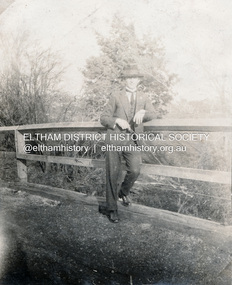
Photograph, Jim Jenkins, Kaylock's Bridge
Pages from a scrapbook belonging to Heather Jenkins (nee Sargeant) who lived as a child in the Police Residence at 728 Main Road, Eltham in the 1920s.Heather Sargeant was the daughter of Constable W.C. Sargeant, the local police officer in residence at Eltham, 1922-1927Glued on a brown paper scrapbook page (torn from scrapbook) with 8 black and white/sepia photos of varying sizes, 1 newspaper clipping and one greeting card with printed sketch and handwritten captions in ink. On back of page is 1 black and white photo and a large newspaper clipping.eltham, police residence, heather jenkins (nee sargeant), walter withers, constable w.c. sargeant, jim jenkins, kaylocks bridge -
 Eltham District Historical Society Inc
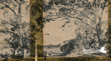
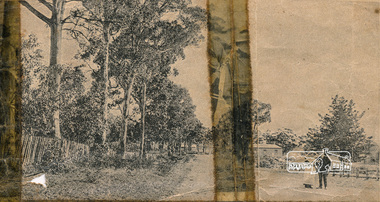
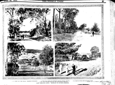
Newspaper clipping, 1. A peep on the road, nearing Research.; New Railway Line: Eltham to Hurst's Bridge; The Weekly Times, 24 Feb 1912, p27, 1912
Pages from a scrapbook belonging to Heather Jenkins (nee Sargeant) who lived as a child in the Police Residence at 728 Main Road, Eltham in the 1920s. Images featured are 1. A peep on the road, nearing Research. 2. The Main Road at Eltham (opposite Railway Station). 3. A part of the new railway line. 4. The mail coach leaving for Kangaroo Ground.Heather Sargeant was the daughter of Constable W.C. Sargeant, the local police officer in residence at Eltham, 1922-1927Detail from large newspaper clipping (half page), very aged and fragile with sticky tape holding it together with 4 images of early Elthameltham, heather jenkins (nee sargeant), main road, research (vic.) -
 Eltham District Historical Society Inc
Newspaper clipping, 2. The Main Road at Eltham (opposite Railway Station).; New Railway Line: Eltham to Hurst's Bridge; The Weekly Times, 24 Feb 1912, p27, 1912
Pages from a scrapbook belonging to Heather Jenkins (nee Sargeant) who lived as a child in the Police Residence at 728 Main Road, Eltham in the 1920s. Images featured are 1. A peep on the road, nearing Research. 2. The Main Road at Eltham (opposite Railway Station). 3. A part of the new railway line. 4. The mail coach leaving for Kangaroo Ground.Heather Sargeant was the daughter of Constable W.C. Sargeant, the local police officer in residence at Eltham, 1922-1927Detail from large newspaper clipping (half page), very aged and fragile with sticky tape holding it together with 4 images of early Elthameltham, heather jenkins (nee sargeant), main road, eltham railway station -
 Eltham District Historical Society Inc
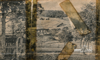
Newspaper clipping, 3. A part of the new railway line.; New Railway Line: Eltham to Hurst's Bridge; The Weekly Times, 24 Feb 1912, p27, 1912
Pages from a scrapbook belonging to Heather Jenkins (nee Sargeant) who lived as a child in the Police Residence at 728 Main Road, Eltham in the 1920s. Images featured are 1. A peep on the road, nearing Research. 2. The Main Road at Eltham (opposite Railway Station). 3. A part of the new railway line. 4. The mail coach leaving for Kangaroo Ground.Heather Sargeant was the daughter of Constable W.C. Sargeant, the local police officer in residence at Eltham, 1922-1927Detail from large newspaper clipping (half page), very aged and fragile with sticky tape holding it together with 4 images of early Elthameltham, heather jenkins (nee sargeant), railway, railway line, edendale farm, mummery's -
 Eltham District Historical Society Inc
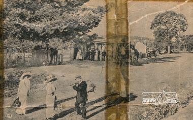
Newspaper clipping, 4. The mail coach leaving for Kangaroo Ground.; New Railway Line: Eltham to Hurst's Bridge; The Weekly Times, 24 Feb 1912, p27, 1912
Pages from a scrapbook belonging to Heather Jenkins (nee Sargeant) who lived as a child in the Police Residence at 728 Main Road, Eltham in the 1920s. Images featured are 1. A peep on the road, nearing Research. 2. The Main Road at Eltham (opposite Railway Station). 3. A part of the new railway line. 4. The mail coach leaving for Kangaroo Ground.Heather Sargeant was the daughter of Constable W.C. Sargeant, the local police officer in residence at Eltham, 1922-1927Detail from large newspaper clipping (half page), very aged and fragile with sticky tape holding it together with 4 images of early Elthameltham, heather jenkins (nee sargeant), railway, railway line, mail coach, eltham railway station -
 Eltham District Historical Society Inc
Newspaper clipping, New Railway Line: Eltham to Hurst's Bridge; The Weekly Times, 24 Feb 1912, p27, 1912
Pages from a scrapbook belonging to Heather Jenkins (nee Sargeant) who lived as a child in the Police Residence at 728 Main Road, Eltham in the 1920s. Images featured are 1. A peep on the road, nearing Research. 2. The Main Road at Eltham (opposite Railway Station). 3. A part of the new railway line. 4. The mail coach leaving for Kangaroo Ground.Digital imageeltham -
 Eltham District Historical Society Inc
Newspaper clipping, 1. A peep on the road, nearing Research.; New Railway Line: Eltham to Hurst's Bridge; The Weekly Times, 24 Feb 1912, p27, 1912
Pages from a scrapbook belonging to Heather Jenkins (nee Sargeant) who lived as a child in the Police Residence at 728 Main Road, Eltham in the 1920s. Images featured are 1. A peep on the road, nearing Research. 2. The Main Road at Eltham (opposite Railway Station). 3. A part of the new railway line. 4. The mail coach leaving for Kangaroo Ground.Heather Sargeant was the daughter of Constable W.C. Sargeant, the local police officer in residence at Eltham, 1922-1927Large newspaper clipping (half page), very aged and fragile with sticky tape holding it together with 4 images of early Elthameltham, heather jenkins (nee sargeant), main road, eltham railway station -
 Eltham District Historical Society Inc
Photograph, Edendale Farm, Eltham Heritage Tour, 24 May 1992, 24/05/1992
ELTHAM HERITAGE TOUR The Society excursion on 24th May 1992 was arranged by David Bick, leader of the team carrying out the Shire's heritage study. David selected a number of sites or buildings identified in the study, some of them lesser known components of the Shire's heritage. The tour commenced at the Eltham Shire Office at 10.00 am. Travel was by private car and mini-bus with stops at about twelve locations for commentary by David.It included a short walk in Hurstbridge and lunch at Kinglake. Highlights of the tour included: - 10 am Leave from Shire Offices - 3 Important Trees - A Physical Link to Eltham's First Settlers - Toorak Mansion Gates - A Surviving Farm House - An Intact Circa 1900 Main Street - First Settlers - Gold Miners, and Timber-getters - An Early Hotel - A Pioneering Homestead - Changing Eltham Shire - 20th Century - 4 pm Afternoon Tea and Finish Tour Extract from ELTHAM CULTURAL HERITAGE TOUR (Newsletter No. 85, July 1992, by Bettina Woodburn) "The land was unprofitable for intensive farming, but there was always water in the Diamond Creek. The railway, a technological advance, followed the valley, and was provided to transport produce. At North Eltham we were privileged to tour a surviving farmhouse of the 1860-70 era at the Shire’s Edendale Farm, with the as yet unfinished Sculpture for a front fence - bulbous tree-trunks decorated with salt pots, with cross members from the old trestle bridge. As was usual these six veranda posted houses faced South (or East, away from the sun!) with the scullery, kitchen and pantry "out the back". The veranda, which must have been very narrow, no longer exists. It probably wrapped around three sides. The drive took us past the Dutch Windmill, only twenty years old and in the Shire of Diamond Valley, then the Diamond Creek Cemetery with impressive gateway, to a detour to see another old farmhouse, isolated on a hill off Murray Road Wattle Glen. Here was a particularly thick patch of exotic planting of pines and cypresses. Subsistence farming no longer pays. Following the rail-line we noticed on the left near Silvan Road an Edwardian cottage and on the right near Yates Road the old school residence for this Upper Diamond Creek area."Record of the Society's history and activities and highlighting various aspects of the Heritage Study undertaken by David Bick used to create the future heritage overlay for the Shire of Eltham and later Nillumbik Shire.Roll of 35mm colour negative film, 4 stripsKodak Gold 100 5095eltham, shire of eltham historical society, activities, heritage tour -
 Eltham District Historical Society Inc
Photograph, 35 Ingrams Road, Research, Eltham Heritage Tour, 24 May 1992, 24/05/1992
ELTHAM HERITAGE TOUR The Society excursion on 24th May 1992 was arranged by David Bick, leader of the team carrying out the Shire's heritage study. David selected a number of sites or buildings identified in the study, some of them lesser known components of the Shire's heritage. The tour commenced at the Eltham Shire Office at 10.00 am. Travel was by private car and mini-bus with stops at about twelve locations for commentary by David.It included a short walk in Hurstbridge and lunch at Kinglake. Highlights of the tour included: - 10 am Leave from Shire Offices - 3 Important Trees - A Physical Link to Eltham's First Settlers - Toorak Mansion Gates - A Surviving Farm House - An Intact Circa 1900 Main Street - First Settlers - Gold Miners, and Timber-getters - An Early Hotel - A Pioneering Homestead - Changing Eltham Shire - 20th Century - 4 pm Afternoon Tea and Finish Tour Extract from ELTHAM CULTURAL HERITAGE TOUR (Newsletter No. 85, July 1992, by Bettina Woodburn) "On a right-angle turning of the Eltham Road is Wellers Pub, a Cobb & Co. coaching stop on the way to distant gold-fields and places north of the Yarra River. The Hotel dates from the 1870's. Daily distances for a bullock team was eight miles, horses could do double that distance. We turned into Cassells Road and on the corner of Ingrams Road we admired an elaborate Edwardian villa, 1900 style. The Aqueduct conveying Melbourne's water supply was a communication line and a technological advance in 1891. It has been enlarged and re-faced and no longer used here but piped underground. Proclaimed a linear park it has reverted to crown land, controlled by local Council. Maroondah Dam was constructed in. 1920 to replace the original weir and at that time: the Aqueduct - as established into the landscape - with bridges and tunnels and pine trees were used to stop rubbish polluting the water."Record of the Society's history and activities and highlighting various aspects of the Heritage Study undertaken by David Bick used to create the future heritage overlay for the Shire of Eltham and later Nillumbik Shire.Roll of 35mm colour negative film, 4 stripsKodak Gold 100 5095shire of eltham historical society, activities, heritage tour, ingrams road, research (vic.) -
 Eltham District Historical Society Inc
Photograph, Woodburn residence, mudbrick adobe (1949), Eltham Heritage Tour, 24 May 1992, 24/05/1992
ELTHAM HERITAGE TOUR The Society excursion on 24th May 1992 was arranged by David Bick, leader of the team carrying out the Shire's heritage study. David selected a number of sites or buildings identified in the study, some of them lesser known components of the Shire's heritage. The tour commenced at the Eltham Shire Office at 10.00 am. Travel was by private car and mini-bus with stops at about twelve locations for commentary by David.It included a short walk in Hurstbridge and lunch at Kinglake. Highlights of the tour included: - 10 am Leave from Shire Offices - 3 Important Trees - A Physical Link to Eltham's First Settlers - Toorak Mansion Gates - A Surviving Farm House - An Intact Circa 1900 Main Street - First Settlers - Gold Miners, and Timber-getters - An Early Hotel - A Pioneering Homestead - Changing Eltham Shire - 20th Century - 4 pm Afternoon Tea and Finish Tour Extract from ELTHAM CULTURAL HERITAGE TOUR (Newsletter No. 85, July 1992, by Bettina Woodburn) "In some respects Eltham is a 'back-water' and it has its own distinctive flavour. On the outskirts the homes date from the 1960's, 70's and 80s with a sprinkling of 'earth homes', mud-brick or pise, rammed dirt. Crossing Main Road into Beddoe Street and Thompson Crescent a very pleasant drive past pines and old fence lines, front lawns unfenced, the occasional ·old farm building, we eventually looked down on a huge circular roof of a 1992 adobe home. Other distinctive places included the Pauline Toner Butterfly Reserve, Gordon Ford's splendid garden at Fulling in Pitt Street, cypress hedges and old houses in Bridge Street and in every direction Eltham's special feature - a totally treed horizon. We were now in the part of the Shire closest to Melbourne - Montmorency - not on the way to anywhere, with no through road going across it, developed in the 1950's and 1960's with conventional gardens, now converted to native plants. The rail looped between Greensborough and Eltham and a shopping street (Were Street) served the area, growing up the hill from the station. It was a typical outer Melbourne suburb with lawns and roses with patches of originality. The shopping precinct still has 1950 characteristics - walls which sloped back, projecting roofs, the original shop fronts are nearly all tiled below the old windows. There's an air of past times about the School, the Dairy, the Butcher's (now a milk bar) and the Castlemaine stone face of the Commonwealth Bank. The final stop for the tour was at the mud-brick Woodburn residence, adobe of 1949 with additions. After War Service, Bill Woodburn had commenced an Architecture course at Melbourne University and after second year in the Christmas vacation, with his wife, Betti, built the two bedroom house - with amazing saving of costs. In the three and a half months they made over 3000 bricks (external walls 18" x 12" x 4", internal walls 12" x 9" x 4"), sifted top soil for mortar and laid them, on concrete foundations and slab floor, made all the structural window frames, door frames and roof members to carry 'super six' asbestos sheets, laboured for the electrician and plumber, did all the glazing and, still without electricity, moved in in March 1949. Rooms have been added, at first with glass walls, later using concrete blocks, to accommodate three daughters and a son. The house not only grew from the earth, but also with the family."Record of the Society's history and activities and highlighting various aspects of the Heritage Study undertaken by David Bick used to create the future heritage overlay for the Shire of Eltham and later Nillumbik Shire.Roll of 35mm colour negative film, 4 stripsKodak Gold 100 5095shire of eltham historical society, activities, heritage tour, woodburn house -
 Eltham District Historical Society Inc
Photograph, Upper Yarra Dam, Spring Tour, 22 Oct 1995, 22/10/1995
EXPLORING THE UPPER YARRA (Newsletter No. 105, November 1995, by Bettina Woodburn) We enjoyed the Spring Excursion, this year "Exploring the Upper Yarra" - in spite of the constant rain and the countryside under the cloud cover, especially in the valleys, being mainly shiny shades of green. The occasional fields of buttercups, clumps of arum lilies and splendid rhododendron and other flowering bushes became very special. The Cobb and Co coach was warm and a cosy retreat as we zig-zagged on the highways and byways to glimpse the Yarra River, upstream and down, its secret places, and particularly the many bridges. Russell excelled as 'Poet Laureate', reading from Dacre Smyth's book. This 1979 publication includes paintings of all the bridges along the river with poems and brief descriptions of each one. Some of the bridges are in out of the way places and are not very well known. We looked forward to hearing the poetry as much as seeing the ' constructions'…Big Pat (was he short or tall, lean or fat? He did win the two hundred pound reward for discovering gold and had the creek named after him), about the 'Eddies'?, and the disliked 'meccano' bridge in Warburton, etc. etc. The hot roast lunch in the old Reefton Hotel was also most welcome. It was easy to imagine it peopled by miners and early settlers. Starting by crossing the new (1974) concrete bridge at Warrandyte we headed through Wonga Park with views to the Christmas Hills and to the escarpment of the Yering Gorge, which causes flood waters to back up through the Yarra Glen plain, so avoiding disasters downstream. At the end of a long driveway we found the wooden, privately owned Henley Bridge (1935 after the 1934 floods). This facilitates access to different parts of Henley Farm and to Lilydale. Everard Park, named after Blanche Shallard's father, a State Member for 17 years, below the Highway Yarra crossing was in need of care. It is 10 miles from Yarra Glen by road but, as "Yarra Marra” canoeists well know, 32 winding miles down by water. After more delightful countryside scenes we joined the Warburton Highway at Woori Yallock. From the old Railway Station at Launching Place the Centennial Trail for walkers, cyclists and ' horse riders has replaced the rails. The line from Lilydale was opened in 1901, and the last diesel freight train ran to Warburton in 1965. It continued to rain as we had morning tea in Warburton in a shelter between footbridges. From here we continued upstream past the Bridge to O'Shannasy Lodge and Reservoir, Starvation Creek, and the Peninsular tunnel (miners dug it as at Pound Bend) which we visited (scrambling down those steps!) on our return after lunch. Our furthermost point was the Upper Yarra Dam Reserve (and vast catchment area). Finished in 1957 after ten years work and 100 years after Yan Yean, it supplies much of Melbourne's water. After crossing the 30m Launching Place Bridge to the Eltham side of the Yarra and Healesville, we saw in the distance the Yarra Glen Timber Trestle Bridge over the river flats "the longest for years in the land it was said!" Harry's dream of "better weather over the Divide" unfortunately didn't come true, but I'm sure we 36 members will retain happy memories of a day that was wet and green and filled with Bridges. Bettina Woodburn - October 1995 Record of the Society's history of activities - Spring 1995 excursionRoll of 35mm colour negative film, 3 stripsKodak Gold 200-4shire of eltham historical society, activities, upper yarra dam, henley bridge