Showing 10987 items matching "land "
-
 Kew Historical Society Inc
Journal - Visitor Book, [1962-1963]
"Fairyland", the home of Jim and Grace Tabulo, was a notable local, state and international tourist attraction situated in Kew, Victoria during the mid twentieth century. Located at 57 Malmsbury Street, Kew, the weatherboard house and its garden were heavily decorated with statues, crockery and other collected items. A series of notebooks were used to record the messages of child and adult visitors to the property from the 1940s to the 1960s. After Mrs Tabulo's death, these visitor books are believed to have formed part of the Dorothy Rogers Collection. They entered the Kew Historical Society's collection following Dorothy Roger's death in 1973.This series of visitor books are the most important primary sources relating to the internationally renowned 'Fairyland' cottage in Malmsbury Street, Kew. Their social significance is that they record in the post war period the values and beliefs of children and adults who visited this historically significant tourist attraction.Foolscap size visitor book containing handwritten comments and drawings primarily made by children during visits to the home of Grace Tabulo, 4 January 1962- 30 January 1963. Commonly known as "Fairyland", the house was located at 57 Malmsbury Street Kew. The book is wrapped in brown paper, which covers back cardboard covers with a red cloth strip binding. Approximately 139 pages, and covers. Note pages are paginated, commencing at page 36.Handwritten in pencil on paper cover: "1962/ 1963" Handwritten in ink on label adhered to front cover: "January 4 / 1962 / Fairy Land/ Kew"grace tabulo -- fairyland -- 57 malmsbury street -- kew (vic.), tourism - kew - 1945-1965, childhood - kew, collectors and collecting, gardens - kew (vic), scrapbooks - 20th century -
 Lakes Entrance Historical Society
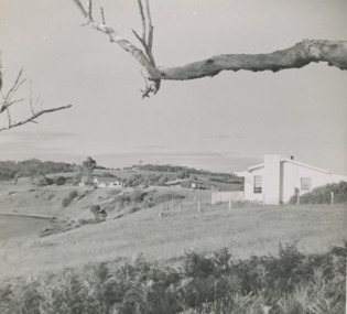
Photograph - " Corumbene" Carpenter Street Lakes Entrance, 1/11/1952 12:00:00 AM
White house in foreground Basil and Joan Mitchelson's, white house closer to Corumbene home of Jack and Aileen Daniel. Land adjacent to North Arm later subdivided for residential development Lakes . Corumbene later subdivided fronted by Carpenter Street today. House moved from Coates Rd to O'Neils Rd Lakes Entrance 1989 Black and white photograph of the property Corumbene at back of photograph behind tall tree c1952. White house in foreground Basil and Joan Mitchelson's, white house closer to Corumbene home of Jack and Aileen Daniel. Land adjacent to North Arm later subdivided for residential development Lakes Entrance Victoria. Also another black and white photographs showing property Corumbene later subdivided fronted by Carpenter Street today. Plus 2 coloured photos of a house being moved from Coates Rd to O'Neils Rd Lakes Entrance 1989land development, houses -
Glenelg Shire Council Cultural Collection
Photograph, Photograph Reclamation and Canal Work, 1959
Port of Portland Authority ArchivesFront: General view: Aerial view West showing wharf and canal areas. November 1959 - typed.port of portland -
Glenelg Shire Council Cultural Collection
Photograph, Photograph - Reclamation and Canal Work, 1959
Port of Portland Authority ArchivesBack: 1959 - black biroport of portland -
Glenelg Shire Council Cultural Collection
Photograph - Photograph - Queen Elizabeth II and Prince Phillip, 1970, 1970
From the Glenelg Shire Council records. The royal visit took place in 1970. The Queen and Prince Phillip visited Portland.Black and white photo. Queen Elizabeth II and Prince Phillip being driven in open land rover, past crowd of school children at Hanlon Park, Portlandroyal visit, queen elizabeth ii, prince phillip, 1970 -
Glenelg Shire Council Cultural Collection
Photograph - Photograph - Aerial photograph of coastline around Portland, Victoria, c. 1954
Black and white aerial photograph of coastline around Portland. Black border, scale all sides, 5 rows of 3 't' at regular intervals. Mostly landFront: '607 - 52 ' - handwritten, white, border 'RUN 7 ' 'PORTLAND', printed, white, border -
Glenelg Shire Council Cultural Collection
Photograph - Photograph - aerial view of Portland, c. 1954
Black and white aerial photograph of coastline around Portland. Black border, scale all sides, 5 rows of 3 't' at regular intervals. Mostly landFront: '607 - 53 ' - handwritten, white, border 'RUN 7 ' 'PORTLAND', printed, white, borderaerial photography, central portland, portland harbour, south west coastline -
 Kiewa Valley Historical Society
Black and White photograph of Road Making Machinery, Kiewa Road Making 25/08/1938 No. 2, 25/08/1938
Construction of the main road from South Tawonga to the Bogong High Plains, to provide access to the construction sites for the new Kiewa Hydro Electric Scheme, was commenced early in 1938, the work being undertaken on behalf of the commission by the Country Roads Board. For the construction work, the Commission purchased three Caterpillar - model R07 - diesel crawler tractors equipped with Kay Brunerei (Brunner) hydraulically operated trailbuilders (angle dozers). This acquisition resulted from a visit to the United States of America in May, 1937 by the Construction Engineer ( Mr. C.H. Kernot) and Assistant Civil Engineer ( Mr. J.F. Douglas) where they saw this relatively new type of equipment in use. With the co-operation of the CRB, the Commission demonstrated the operation of these machines at Fishermen's Bend on 6th April, 1938. They were then sent to Kiewa where they commenced operation towards the end of the month. From South Tawonga, the route let immediately across the Western Branch of the Kiewa River necessitating the construction of a bridge 100 feet long. By the end of 1939, the excavation had been 'opened up' for a distance of 19 1/2 miles (approx. 31 km.) and of this length, 10 miles (approx. 16 km.) had been surfaced. (see KVHS 0328)The purchase of this type of mechanical equipment in road making was a huge investment, as prior to this most of the work would have been done manually with the use of picks and shovels. Not only were many months of hard manual labour saved, but a very significant amount of time in providing access to the proposed work sites for the new Kiewa Hydro Scheme. This photo is an excellent reminder of how primitive the early machinery was compared to the present but also represents the forward thinking of the State Electricity Commissions engineers in purchasing such innovative equipment.A black and white photograph of road making near Mt. Beauty in 1938. Mount Beauty hills can be seen in the background with cleared land for grazing in the fore ground.Hand printed in black ink at the top of the photograph is 'Kiewa Road Making 25/8/1938'. On the right hand corner has been printed the number 2. It has been printed on gloss Velox paper.road making, state electricity commission, caterpillar tractor, kiewa, secv -
Glenelg Shire Council Cultural Collection
Photograph - Photograph - Main Breakwater Construction, n.d
Port of Portland Authority Archivesport of portland archives, portland harbour, reclaimed land, battery point -
Glenelg Shire Council Cultural Collection
Photograph - Photograph - Portland Harbour, Main Breakwater Construction, n.d
Port of Portland Authority Archivesport of portland archives, harbour construction, wharf, battery point -
 Bendigo Historical Society Inc.
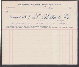
Document - CAMBRIDGE PRESS COLLECTION: ACCOUNT - J. F. KELLY
Account page from J F Kelly & Co, House Land and Estate Agents. Date line ends 193-. Printed in light and dark blue and red.business, printers, cambridge press, cambridge press collection, j f kelly & co, j f kelly, f j byrne, city mutual fire insurance company limited -
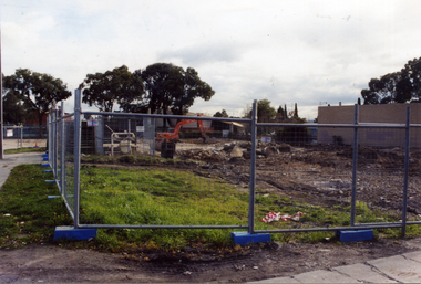
Port Melbourne Historical & Preservation Society
Photograph - Port Melbourne foreshore behind the piers prior to redevelopment, Dec 1992
Nine colour, wide angle photographs of the Port Melbourne foreshore and adjacent land behind Station and Princes Piers before the high-rise development, Dec 1992piers and wharves - princes pier, natural environment, transport - railways -
 National Vietnam Veterans Museum (NVVM)
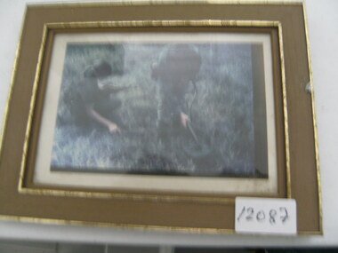
Photograph, Mine Detection
Photograph of 2 soldiers in jungle greens sweeping for land mines. 1 solider is drouching with an SLR. The other solider carries a mine sweeper and is wearing head phonesphotograph, mine sweeping, slr -
 Whitehorse Historical Society Inc.
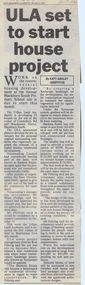
Article, ULA set to start house project, 6/10/1992 12:00:00 AM
Article on the development of 'Banksia Estate',Article on the development of 'Banksia Estate', former site of Blackburn South Primary School, Branksome Grove, by the Urban Land Authority. In Nunawading Gazette, 6 October 1992.Article on the development of 'Banksia Estate', banksia estate, victoria. urban land authority, blackburn south primary school, no. 4035, xeriscope, water supply, canterbury road, blackburn south, branksome grove, land subdivision -
 Whitehorse Historical Society Inc.
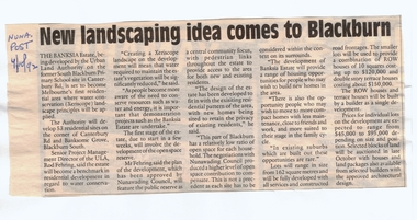
Article, New landscaping idea comes to Blackburn, 4/10/1992 12:00:00 AM
Article on the development of 'Banksia Estate',Article on the development of 'Banksia Estate', former site of the Blackburn South Primary School, Branksome Grove, by the Urban Land Authority. In Nunawading Post, 4 October 1992.Article on the development of 'Banksia Estate',banksia estate, victoria. urban land authority, blackburn south primary school, no. 4035, xeriscope, water supply, canterbury road, blackburn south, branksome grove, land subdivision -
 Whitehorse Historical Society Inc.
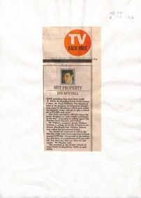
Newspaper - Article, Hot property, 1/09/1994
Sale of 32 blocks of land on former Blackburn East Primary School site, now known as Greenwood Estate. Expected purchase range between $80,000 and $100,000.williams, lloyd, fletcher and parker, hudson conway property group, blackburn east primary school, no. 4800, vicki street, blackburn south -
Whitehorse Historical Society Inc.
Map, Nunawading Planning Scheme, 7/06/1994 12:00:00 AM
Local Section maps 1 - 4 with index. Geographical information system land Information Branch. Scale 1:10,000 Shows zoning under planning scheme.Local Section maps 1 - 4 with index. Geographical information system land Information Branch. Scale 1:10,000 Shows zoning under planning scheme.Local Section maps 1 - 4 with index. Geographical information system land Information Branch. Scale 1:10,000 Shows zoning under planning scheme.blackburn, blackburn north, blackburn south, forest hill, heatherdale, maps, nunawading, vermont, vermont south, town planning, burwood east, laburnum -
Whitehorse Historical Society Inc.
Article, Sites for training scheme, 1993
Vacant land in Nunawading should be used for an employment training scheme to help long term unemployed.Vacant land in Nunawading should be used for an employment training scheme to help long term unemployed. Council wants to know what the community thinks about the idea.Vacant land in Nunawading should be used for an employment training scheme to help long term unemployed.youth, shambrook, tim, gardiner, bob -
Whitehorse Historical Society Inc.
Map, VR Box Hill - Blackburn, 1953
Maps of proposed station at Laburnum on Box Hill to Blackburn railway lines, by Victorian Railways, showing boundaries of Victorian Railways land and the proposed boundaries for Laburnum Station.Maps of proposed station at Laburnum on Box Hill to Blackburn railway lines, by Victorian Railways, showing boundaries of Victorian Railways land and the proposed boundaries for Laburnum Station.Maps of proposed station at Laburnum on Box Hill to Blackburn railway lines, by Victorian Railways, showing boundaries of Victorian Railways land and the proposed boundaries for Laburnum Station.laburnum railway station, laburnum street, blackburn, victorian railways -
Whitehorse Historical Society Inc.
Document, Property report, 1987
Property Report: Land at cnr. of Burwood Highway and Station Street BurwoodProperty Report: Land at cnr. of Burwood Highway and Station Street Burwood. For sale by tender on behalf of the Royal Victorian Institute for the Blind. Agent: Baillieu Knight Frank.Property Report: Land at cnr. of Burwood Highway and Station Street Burwoodburwood highway box hill south, station street box hill south, royal victorian institute for the blind, baillieu knight frank -
 Whitehorse Historical Society Inc.
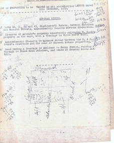
Legal record - Correspondence, Valuation of properties, 24/12/1929 12:00:00 AM
List of property valuations for Mitcham Riding of the Shire of Blackburn and Mitcham dated 24 / 12 / 1929.List of property valuations for Mitcham Riding of the Shire of Blackburn and Mitcham dated 24 / 12 / 1929. Valued by C. Morton of land that was being considered for parks in 1930.List of property valuations for Mitcham Riding of the Shire of Blackburn and Mitcham dated 24 / 12 / 1929. mitcham riding, mitcham road, shire of blackburn and mitcham, land values, charlesworth estate, mitcham, harrison street, burnett street, antonio, cook, w, whitehorse road, lucknow street, creek road, rooks, gell, percy street -
 Whitehorse Historical Society Inc.
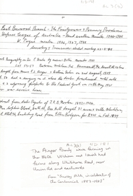
Map, Frank Ainger, 1873
Application by Frank Ainger for land in the Parish of Nunawading on Whitehorse Road near Mitcham Road. Also included are several references from other sources to Frank Ainger.ainger, frank, shire of nunawading, mitcham, land settlement -
Whitehorse Historical Society Inc.
Document - Illustration, George Gatter, n.d
Photocopy of photo of George Gatter, 1828 - 1886, market gardener, purchased land in Box Hill 1861.Photocopy of photo of George Gatter, 1828 - 1886, market gardener, purchased land in Box Hill 1861. First secretary , Horticultural and Agricultural Society of South Bourke.Photocopy of photo of George Gatter, 1828 - 1886, market gardener, purchased land in Box Hill 1861. gatter, george, market gardeners -
 Whitehorse Historical Society Inc.
Article, Heritage concern over site, 10/12/1997 12:00:00 AM
Report on application to build 16 two-storey town housesReport on application to build 16 two-storey town houses on land at 456 Mitcham Road, Mitcham. There have been 42 objections from near-by residents.Report on application to build 16 two-storey town houses kirisopoulos, jenny, daly, peter, nunawading and district historical society, walling, edna, australian tesselated tile co pty ltd., walker estate -
 Whitehorse Historical Society Inc.
Photograph, Colombo Street, Mitcham, 2006
Development of fourteen story apartment block. Given a permit in 2004. Permit not extended on 2007.Coloured photo of land for proposed development of a fourteen storey apartment block in Colombo Street, Mitcham (previously site of Brewer Sporting Goods Manufacturing Goods Factory)colombo street mitcham, high-rise buildings -
 8th/13th Victorian Mounted Rifles Regimental Collection
Photograph
The extensive stock routes of the Booligal area made a good training area for a reconnaissance squadron.Black and white photograph of Private Roche, A Squadron 8/13 Victorian Mounted Rifles at wheel of Land Rover during annual exercise in Booligal area 1983. -
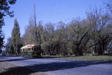 Ballarat Tramway Museum
Slide - 35mm slide/s, Robert Thomson, 2/04/1964 12:00:00 AM
Yields information about Ballarat's trams during 1964 and Wendouree Parade.Kodachrome cardboard mount, colour slide of No. 39 travelling south in Wendouree Parade, fairly land. Tram has the destination of Gardens via Drummond St North."Ballarat Single truck 32 2-4-64" in ink.tramways, trams, gardens loop, wendouree parade, tram stops, tram 39 -
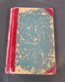 Bendigo Historical Society Inc.
Administrative record - Mallee Index
Blue and red Index book. The book contains list of names in alphabetical order, next to the names a series of numbers. Possibly relating to land sales. Date unknown. Mallee index on the spineledger, name index, mallee -
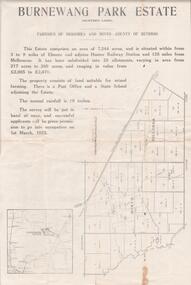 Bendigo Historical Society Inc.
Document - EDWIN BUCKLAND COLLECTION: BURNEWANG PARK ESTATE, 1982
Document. Burnewang Park Estate. Applications re closer Settlement board from Discharged Soldiers holding Qualification certificates to take up land for Farm Allotments. -
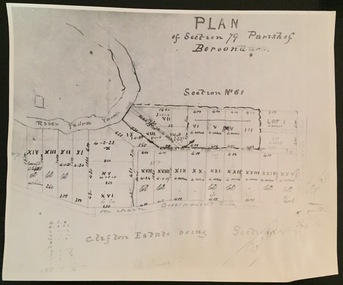 Kew Historical Society Inc
Print - Subdivision Plan (copy), Plan of Section 79 Parish of Boroondara (Clifton Estate), Nineteenth Century
This work forms part of the collection assembled by the historian Dorothy Rogers, that was donated to the Kew Historical Society by her son John Rogers in 2015. The manuscripts, photographs, maps, and documents were sourced by her from both family and local collections or produced as references for her print publications. Many were directly used by Rogers in writing ‘Lovely Old Homes of Kew’ (1961) and 'A History of Kew' (1973), or the numerous articles on local history that she produced for suburban newspapers. Most of the photographs in the collection include detailed annotations in her hand. The Rogers Collection provides a comprehensive insight into the working habits of a historian in the 1960s and 1970s. Together it forms the largest privately-donated collection within the archives of the Kew Historical Society.A photographic reproduction of a plan in the Vale Collection of the State Library of Victoria. The numbered lots represent the first land sales in Kew in the area north of Studley Park Road.maps (kew), plan of section 79 parish of boroondara