Showing 25660 items
matching plenty-township-estate
-
 City of Moorabbin Historical Society (Operating the Box Cottage Museum)
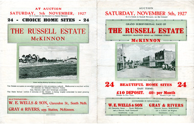
Flyer - Russell Estate, McKinnon
The train line from the city to Frankston was electrified in 1922 which intensified the sale in the municipality of Moorabbin, particularly land which was in the vicinity of the railway stations.Example of the progress of the Municipality of MoorabbinAdvertising flyer for auction of real estate sales - plan of building blocks for saleRussell Estate, McKinnon - 24 home sites - Auction 5 November 1927 - W.E. Wells and Sons, Gray and Riversmckinnon road, thomas street, hopkins street, mckinnon, real estate, auction -
 National Wool Museum
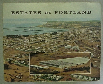
Booklet, Estates at Portland
Cover of booklet describing the Australian Estates Company building in Portland, Victoria, as well as a background on Portland."Estates at Portland"wool stores, australian estates company ltd -
 Kiewa Valley Historical Society
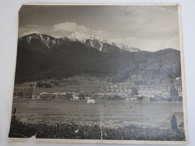
Photo - Mt Beauty c1948, Early photo of Mt Beauty Townhip c1948
Mt Beauty was constructed by the State Electricity Commission of Victoria to house employees of the Kiewa Hydro Electric Scheme. Mt Beauty township looking south east from Hollond's property c1948. Only one transmission line has been built.In the foreground are houses in Simmond's Creek Road. Some houses in North Beauty. The town is still under construction - not all roads have been made and houses haven't any garden around them.This is an early photo of Mt Beauty during construction of the town.d It shows a few houses in Simmonds Creek Road. Large black and white photo of Mt Beauty township with snow on the mountains in the background.mt beauty township 1948, mt beauty construction, simmonds creek road -
 Kiewa Valley Historical Society
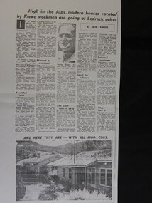
Newspaper Article Copy - Sale of Mt Beauty Town, 1960's
Mt Beauty township was sold in the 1960's after the State Electric Commission of Victoria had finished the construction of the Kiewa Hydro Electric Scheme. The sale of Mt Beauty township signified the end of construction of the Kiewa Hydro Electric Scheme and the beginning of Mt Beauty under the Bright Shire (now Alpine Shire). Many of the workers for the State Electricity Commission of Victoria remained in Mt Beauty and many returned to retire in the town in later years.An A3 sized Photocopy of the newspaper article regarding the sale of the Mt Beauty township with a photo of George Rosen and two houses and an A4 newspaper photocopy of the headline newspaper; mt beauty sale; secv; bright shire -
 Lakes Entrance Regional Historical Society (operating as Lakes Entrance History Centre & Museum)
Postcard, Murray View Gympie Qld, 1970 c
Also a second postcard lookin west showing township, North Arm and Kalimna Heights 05213.1 10 x 15 cmBlack and white postcard showing ariel of township, North Arm and Cunninghame Arm, Bullock Island and part of Kalimna Heights and Jemmys Point Lakes Entrance VictoriaAerial view of Lakes Entrance Vicbridges -
Eltham District Historical Society Inc
Folder, Mr Lawford, 1850s
Folder of information on Mr Lawford, Plenty River, 1850slawford -
Eltham District Historical Society Inc
Folder, John Foxton, 1850s
Folder of information on John Foxton, Lower Plenty, 1850sjohn foxton -
Lakes Entrance Regional Historical Society (operating as Lakes Entrance History Centre & Museum)
Photograph, L Carpenter, 1952 c
Also two black and white photographs of Western part of township taken from sand hummocks across Cunninghame Arm 04315.1 and 04315.2 15 x 11 cm and 11 x 15 cmBlack and white photograph of part of the township taken from shore of sand hummocks looking across Cunninghame Arm Lakes Entrance Victoriafishing industry, jetties -
 City of Moorabbin Historical Society (Operating the Box Cottage Museum)
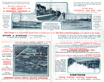
Flyer - Moorabbin Electric Station Estate, Moorabbin, 1925
The train line from the city to Frankston was electrified which intensified the sale in the municipality of Moorabbin, particularly land which was in the vicinity of the railway stations.Example of the progress of the Municipality of MoorabbinAdvertising flyer for auction of real estate sales - plan of building blocks for saleMoorabbin Electric Station Estate, Moorabbin - Auction Saturday 30 May 1925 - 65 Residential allotments Auctioneer Knight & Harwoodmoorabbin station, south road, station street, jasper street (now redholme street), central avenue, moorabbin, real estate, auction -
 City of Moorabbin Historical Society (Operating the Box Cottage Museum)
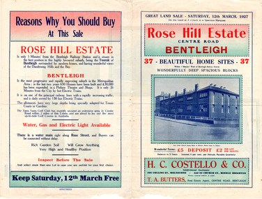
Flyer - Rose Hill Estate, 1927
The train line from the city to Frankston was electrified in 1922 which intensified the sale in the municipality of Moorabbin, particularly land which was in the vicinity of the railway stations.Example of the progress of the Municipality of MoorabbinAdvertising flyer for auction of real estate sales - plan of building blocks for saleRose Hill Estate, Bentleigh - 37 home sites - Auction Saturday 12 March 1927 - H. C. Costello & Cocentre road, rose street, real esate, auction, bentleigh -
 Orbost & District Historical Society
black and white photograph, late 19th / early 20th century?
This photograph shows a distant view of the Orbost township taken from Grandview Lookout at Newmerella. It appears to have been taken before the railway line was there.This is a pictorial record of early Orbost.A small black / white photograph of the Orbost township taken from Grandview Lookout , Newmerella. The main road can be seen below with paddocks of crops on both sides.on back - "Distant View, Orbost from Grandview"orbost-township-c19th grandview-lookout orbost-flats-paddocks -
Whitehorse Historical Society Inc.
Map, Dandenong Ranges Area, 1955
Sheet 13. Parts of Parishes: Nunawading, Mulgrave and Scoresby.Sheet 13. Parts of Parishes: Nunawading, Mulgrave and Scoresby. Includes area of Vermont South marked as proposed Township of Norwich. Scale 10 chains : 1 inch. Contours marked.Sheet 13. Parts of Parishes: Nunawading, Mulgrave and Scoresby. maps, vermont south, wantirna, dandenong creek -
 Stawell Historical Society Inc
Photograph, Pioneers Memorial on Big Hill -- Sunset through its Columns -- Coloured
Looking through Pioneers Memorial Columns. The photo shows the ground floor of the Pioneers memorial with the Corinthian pillars supporting the dome. The directional pedestal is in the center installed in c 1947. The Stawell township is in the background with the sun setting behind the Grampians.Looking through Pioneers Memorial Columns with the directional pedestal in the center. The view shows the Stawell township in the background and the sun setting behind the Grampians.Carol Anne Jonesstawell -
 City of Moorabbin Historical Society (Operating the Box Cottage Museum)
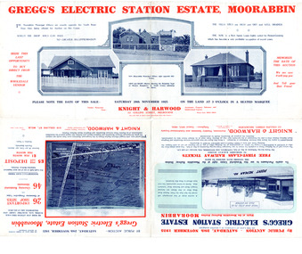
Flyer - Gregg's Electric Station Estate, Moorabbin, 1925
The train line from the city to Frankston was electrified which intensified the sale in the municipality of Moorabbin, particularly land which was in the vicinity of the railway stations.Example of the progress of the Municipality of MoorabbinAdvertising flyer for auction of real estate sales - plan of building blocks for saleGregg's Electric Station Estate, Moorabbin 26 business site and 46 home sites - Knight & Harwood pictures of local sites and buildingssouth road, barry street, south avenue, plym street, moorabbin, moorabbin station, gregg, real estate, auction -
 City of Moorabbin Historical Society (Operating the Box Cottage Museum)
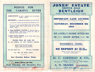
Flyer - Jones' Estate, Bentleigh, 1924
The train line from the city to Frankston was electrified which intensified the sale in the municipality of Moorabbin, particularly land which was in the vicinity of the railway stations.Example of the progress of the Municipality of MoorabbinAdvertising flyer for auction of real estate sales - plan of building blocks for saleJones' Estate, Brewer Road Bentleigh - 63 home sites & 19 business sites - H. C. Costello & Co - A. N. Moorepatterson road, brewer road, phillip street, north avenue, real estate, auction, bentleigh, moorabbin -
 City of Moorabbin Historical Society (Operating the Box Cottage Museum)
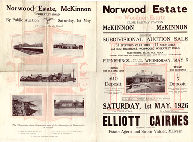
Flyer - Norwood Estate, McKinnon and Woodnor Estate, McKinnon, 1926
The train line from the city to Frankston was electrified which intensified the sale in the municipality of Moorabbin, particularly land which was in the vicinity of the railway stations.Example of the progress of the Municipality of MoorabbinAdvertising flyer for auction of real estate sales - plan of building blocks for saleNorwood and Woodnor Estate, McKinnon 31 Villa Site & 11 Shop sites - Auction Saturday 1 May - Auctioner Elliott Cairnesmckinnon, norwood, wheatley road, jean street, anne street, lysbeth street, mckinnon road, jasper road, real estate, auction -
 City of Moorabbin Historical Society (Operating the Box Cottage Museum)
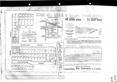
Flyer - Sunny Hill Estate, Carnegie, 1924
The train line from the city to Frankston was electrified in 1922 which intensified the sale in the municipality of Moorabbin, particularly land which was in the vicinity of the railway stations.Example of the progress of the Municipality of MoorabbinAdvertising flyer for auction of real estate sales - plan of building blocks for saleSunny Hill Estate in Carnegie - Ormond District Auction 46 Home sites - 14 Shop sites Auction 9 February 1924rigby ave, leila rd, koornanag road, grandview grove, oakleigh road, mckinnon, ormond, carnegie -
 Hume City Civic Collection
Photograph, c late 1980s
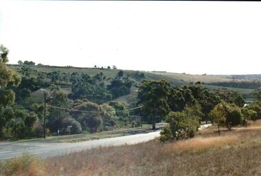
The photograph shows a section of the original settlement of the Bulla township. The cutting on the hillside is significant as it is the remains of one of the original stream crossings in Victoria.A coloured photograph of the Bulla Hill along Sunbury Road with a view of the cutting on the distant hillside. The photograph is a view of the old Bulla township looking to the NW. There is a wide grassy verge in the foreground.bulla township, deep creek, wright, william 'tulip', sunbury road, george evans collection -
 Glen Eira Historical Society
Photograph, Dalny Road, 5-17 Rear, Murrumbeena, 2001
Originally labelled "Beauville Estate, Established 1936, Still Thriving 65 years on, 10th March 2001", the Beauville Estate Album contains colour photographs of houses in the Estate. They were taken around the time of the Beauville Estate’s 65th Heritage Celebration held on 10/03/2001 and donated to the Caulfield Historical Society shortly afterwards. Photographer unknown. From Glen Eira’s Heritage Management Plan by Andrew Ward (1996) Vol 2 p78: "Beauville Avenue is unusual in that it is terminated in a cul-de-sac (see Section 3.9.2) whilst the design of the estate may well be unique for its time in that the houses back onto 6 tennis courts for public use. St. Patrick's Church, which adjoins the estate is a comparatively recent structure whilst the school has one building erected in 1930 and prior to the release of the Beauville lots." It also notes that St.Patrick's Church and School now run the tennis courts. The Beauville Historic Area is important at the State level as the first large housing estate undertaken by the AV Jennings Construction Co, later Jennings Group Limited, Victoria’s largest home builder. It is important also as a very early estate development incorporating a range of features other than houses and including made roads, shops and recreation facilities. In this respect it was the forerunner of the comprehensively planned housing estate of the post war era. The estate is distinguished by its aesthetic values, as is the earlier and comparable Hillcrest Estate, which are formed by a combination of restrained diversity in house styles, with the exception of no. 30 in the emerging International style, and by a landscaped garden environment. See Significance Statement in Glen Eira’s Heritage Management Plan by Andrew Ward (1996) Vol 2 p.79. Available from https://www.gleneira.vic.gov.au/media/4779/heritage_management_plan_volume_2.pdf (Note see p.84 of pdf)Colour photograph of a playground on the Beauville Estate. murrumbeena, houses, 1930's, a.v. jennings, av jennings, jennings, beauville estate, playgrounds, parks and reserves, sir albert victor jennings, a v jennings construction co, beauville estate heritage area, glen eira city council, jennings group limited, land subdivision, gardens, beauville historic area, st patrick's church, st patrick's school, dalny road -
Clunes Museum
Certificate, SWAINSON FAMILY, STATEMENT OF RECEIPTS AND EXPENDITURE
CERTIFICATE OF ESTATE FROM THE SWAINSON FAMILY HOME IN HILL STREET, CLUNES. THAT BEING SALE OF ASSET/S, LAND AND DWELLING, BEING ALLOTMENT 11, SECTION 6, TOWNSHIP OF CLUNES, PARISH OF CLUNES, COUNTY OF TALBOT. SOLD TO MRS. C.K. BUCHANAN. 1918-1919PHOTOCOPIES OF: .1 THE BALLARAT TRUSTEES EXECUTORS & AGENCY COMPANY LIMITED. STATEMENT OF RECEIPTS & EXPENDITURE FOR AND ON A/C OF ESTATE OF JOHN SWAINSON DECEASED DATED 23/9/1919 .2 & .3 PHOTOCOPIES OF THE BALLARAT TRUSTEES EXECUTORS & AGENCY COMPANY LIMITED. ESTATE OF JOHN SWAINSON DECEASED DATED 23/9/1919 .4 COVER LETTER FROM THE BALLARAT TRUSTEES EXECUTORS & AGENCY COMPANY LIMITED TO MRS. L.E. SWAINSON WIDOW OF JOHN SWAINSON DATED 17/10/1918 CHEQUE IN THE AMOUNT OF 93 POUNDS, 19 SHILLINGS AND ZERO PENCE IN LIEU OF THE SIGNED RELEASE.NILlocal history, certificates, swainson family, mrs. c k buchanan -
 Stawell Historical Society Inc
Photograph, Panorama of Stawell from Big Hill -- Sunset -- Coloured
Sunset from Big Hill. The photo shows the Stawell township with the Grampians in the background and the sun setting behind the Grampians. The majority of the image is a view of the cloud formation. Photo taken by Carol Anne JonesColour photograph of sunset from Big Hill. The photo shows the Stawell township with the sun setting behind the Grampians. The majority of the image is a view of the cloud formation.Carol Anne Jonesstawell -
 Marysville & District Historical Society
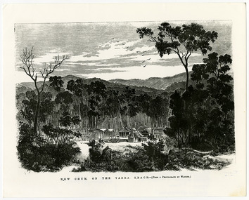
Work on paper (item) - Print of wood engraving, Frederick Grosse et al, New Chum on the Yarra Track, 27-09-1866
A copy of an early wood engraving taken from a photograph of the deserted township of New Chum, near Healesville, on the Yarra Track in Victoria.A copy of an early wood engraving taken from a photograph of the deserted township of New Chum, near Healesville, on the Yarra Track in Victoria. The Yarra Track is the former name of the gold fields road from Healesville to the Woods Point and Jordan Goldfields in Victoria.new chum, healesville, yarra track, victoria, frederick grosse, albert charles cooke, thomas waters, wood engraving -
 Hume City Civic Collection
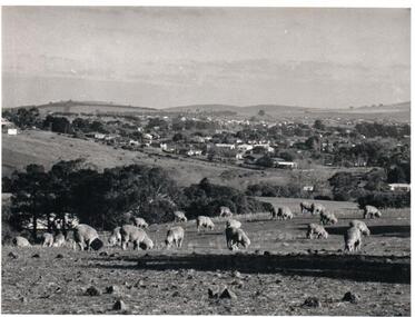
Photograph, Early 1970s
The photograph was taken when Sunbury township did not extend far beyond Anderson Road to the west and Powlett Street to the east. The Paynes housing development can be seen scattered across the hillside between Gap Road and Mitchells Lane.A black and white photograph of a panoramic view of Sunbury township looking west and taken from above the Goonawarra Winery. Sheep are grazing on the hilside in the foreground.sunbury township, goonawarra winery, george evans collection -
Eltham District Historical Society Inc
Folder, Francis Favier, 1960s
Folder of information on Francis Favier, Councillor, Lower Plenty, 1960sfrancis favier -
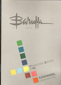
 National Wool Museum
Yarn sample book
Yarn sample book, Zegna Baruffa primavera estate, 1990.Baruffa/ PRIMAVERA ESTATE/1990/I COLORItextile industry merino sheep weaving, zegna baruffa, cloth - woollen, textile industry, merino sheep, weaving -
 Lakes Entrance Regional Historical Society (operating as Lakes Entrance History Centre & Museum)
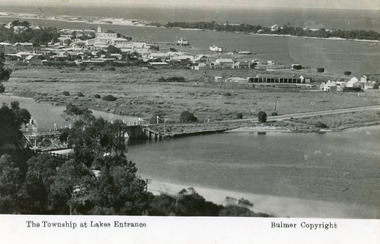
Postcard, Bulmer H D, 1935
Marine Parade has not yet been formed through the low lying marshy area adjacent to North Arm. Very little vegetation on Eastern end of hummocks.Black and white postcard of the western end of Lakes Entrance,showing a glimpse of the North Arm bridge, town situated adjacent to Cunninghame Arm, sand hummocks and ocean in distance. Lakes Entrance VictoriaThe Township at Lakes Entrancetownship, waterways, bridges, hotels -
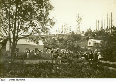 Mt Dandenong & District Historical Society Inc.
Photograph
1915 Olinda Township -
 National Wool Museum
Book, Cloth Sample
Jersey colour sample book, Zegna Baruffa primavera estate, 1990.Baruffa/ PRIMAVERA ESTATE/1990/I COLORItextile industry merino sheep weaving, zegna baruffa, cloth - woollen, textile industry, merino sheep, weaving -
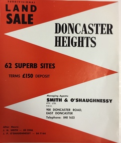 Kew Historical Society Inc
Plan - Subdivision Plan, Doncaster Heights
Real estate brochure produced for Smith & O'Shaughnessy of 900 Doncaster Road for the sale of the '65 superb sites' in the Doncaster Heights Estate. Streets with lots for sale include: Church Road, Norfolk Circuit, and Hampshire Road.Historic subdivision planFour-page colour real estate brochure issued for the sale of the Doncaster Heights Estate. The inside pages include a street plan with the numbered lots.subdivision plans - doncaster, doncaster heights estate -
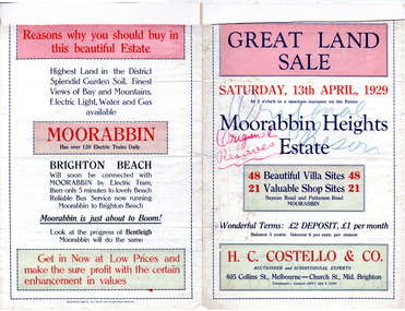 City of Moorabbin Historical Society (Operating the Box Cottage Museum)
Flyer - Moorabbin Heights Estate, Moorabbin, 1929
The train line from the city to Frankston was electrified which intensified the sale in the municipality of Moorabbin, particularly land which was in the vicinity of the railway stations.Example of the progress of the Municipality of MoorabbinAdvertising flyer for auction of real estate sales - plan of building blocks for saleMoorabbin Heights Estate, Moorabbin 48 Villa sties, 21 Shop sites Sale on Saturday 13 April 1929 - H. C. Costello & CO.point nepean road (nepean highway), harding street, howell street, north avenue, coates street