Showing 2967 items
matching mine and mining
-
 Bendigo Historical Society Inc.
Document - ALBERT RICHARDSON COLLECTION: EARLY HISTORY OF THE BENDIGO GOLDFIELD
Typed foolscap two sided document with information about the early history of the Bendigo Goldfield. Topics include the first gold discovery, how gullies were worked, quartz reefing, gold cakes, hand dollies and Chilian mills. Some brief statistics of the Bendigo goldfield include the total gold yield of 17,370,561 ounces plus 5,000,000 oz sold outside Bendigo. The greatest depth reached by any mine in the State, 4,593 feet below surface, or 3,700 feet below sea-level, was attained by the Victoria Quartz Company. About 100 shafts exceed a depth of 1,000 feet, of which 40 are between 2,000 and 3,000 feet deep, fifteen are between 3,000 and 4,000 feet and two are over 4,000 feet.bendigo, mining, mines department -
 Bendigo Historical Society Inc.
Document - ALBERT RICHARDSON COLLECTION: STATE BATTERIES
Two sided foolscap sheet, written on top in pencil: ' To State Battery, Easter Saturday, 21.4.1973 ( Mr. Bert Terrill).' The operation of the six state batteries is described, including the rates for crushing, the procedure of crushing and treatment, and the clean up. State batteries Group 1 were: Bendigo, Bright, Rutherglen. Group 2 Maldon, Edgerton and Wedderburn.Mines Department Museum, State Offices Annexe, 107 Russell Street, Melbourne.bendigo, mining, state battery -
 Bendigo Historical Society Inc.
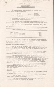
Photograph - KEN BICE COLLECTION: WATTLE GULLY GOLD MINE
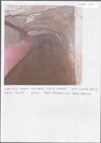
Colour photograph, laminated. On bottom of image: ' Ken Bice trucking from chute at No. 1 level, (60m) Wattle Gully Gold Mine, 1980'mining, underground equipment, wattle gully gold mine -
 Bendigo Historical Society Inc.
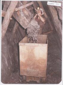
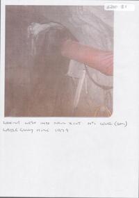
Photograph - KEN BICE COLLECTION: WATTLE GULLY GOLD MINE
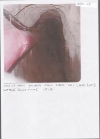
Colour photograph, faded and laminated. Image shows underground tunnel with air line on RH side. On bottom of image:' looking west into main xcut No. 1 level (60m) Wattle Gully Mine 1979.'mining, underground equipment, wattle gully gold mine -
 Bendigo Historical Society Inc.
Photograph - KEN BICE COLLECTION: WATTLE GULLY GOLD MINE
Colour photograph, faded and laminated. Image shows an underground tunnel with air/electricity wiring on LH side of decline. Written on bottom : looking east towards main shaft. No. 1 level (60m) main xcut 1979. Bob Farrell in background'mining, underground equipment, wattle gully gold mine -
 Bendigo Historical Society Inc.
Photograph - KEN BICE COLLECTION: WATTLE GULLY GOLD MINE
Laminated, faded colour photograph. Image shows stope with air lines. On bottom of image: ' looking east towards main shaft No. 1 level, Wattle Gully Mine 1979'mining, equipment, wattle gully gold mine -
 Bendigo Historical Society Inc.
Document - KEN BICE COLLECTION: WATTLE GULLY GOLD MINE 1979
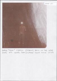
Laminated, faded black and white photograph. Image shows men with back to the camera, standing in a stope with hard hat and fluoro vest. On bottom of image 'Kerry Spud Martin watering down in the lead stope No. 1 level ( 60m) Wattle Gully Mine 1979'.mining, underground equipment, wattle gully gold mine -
 Bendigo Historical Society Inc.
Document - ALBERT RICHARDSON COLLECTION: WATTLE GULLY GOLD MINE
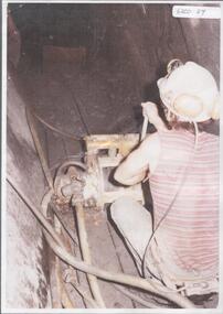
Black and white photo, faded, laminated. Image shows Ken Bice operating a scraper. On back of image ' Ken Bice operating a scraper in intermediate level 6 metres agove No. 1 level (60m) Wattle Gully Mine 1980 working on Gibbers Reef.'mining, underground equipment, wattle gully gold mine -
 Bendigo Historical Society Inc.
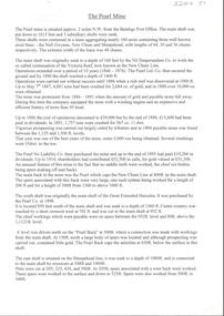
Document - ALBERT RICHARDSON COLLECTION: THE PEARL MINE
Typed, 2 page document, detailing the location and history of the operation of the Pearl Mine. The mine was located approximately 2 miles north west from the Bendigo Post Office. The main shaft was put down to 1613 feet and 3 subsidiary shafts were sunk, Information is given about the south shaft, originally the main shaft of the Great Extended Hercules and the east shaft, which was situated on the Sheepshead line.bendigo, mining, pearl company mine -
 Bendigo Historical Society Inc.
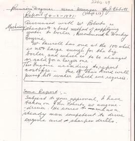
Document - ALBERT RICHARDSON COLLECTION: PRINCESS DAGMAR MINE, GARDEN GULLY LINE
4 page handwritten document, (copy) detailing some of the Mine Manager's reports for Princess Dagmar mine 1881 - 1914. Example: Reportof 8.3.1881, shaft 213, Mine Manager J. Ebboth. 'Discussed with Mr. Roberts re cheapest and bst method of supplying water to boiler, recommend a donkey engine. Mr. Lansell has one at the 180 which is not large enough for the big boiler and which is to be changed or sold for a larger one. This engine according to report costs 20 pounds. One of this kind will pump hot water which we require. Subject to your approval I have taken on John Roberts as engine driver. He comes to me as a steady man competent to drive engine and sharpen drills.'bendigo, mining, princess dagmar -
 Bendigo Historical Society Inc.
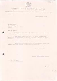
Letter - KANGAROO FLAT GOLD MINE COLLECTION: LETTER TO WESTERN MINING CORPORATION
Letter written by Ken Harris, 85 Lowndes Street, Bendigo, dated 10th November 1974, to Mr. A. Parbo, Managing Director of Western Mining Corporation. Attached to letter is a 3 page document titled 'Some notes on the Bendigo Gold Field' written by Ken Harris. Ken stated that 'Bendigo could have a future in goldmining even surpassing a glorious past'bendigo, gold mining, bendigo goldfield, bendigo, western mining corporation, a. parbo, ken harris, goldmining, goldfields. -
 Bendigo Historical Society Inc.
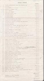
Letter - KANGAROO FLAT GOLD MINE COLLECTION: WESTERN MINING CORPORATION LETTERS
Two copies of letter sent from Western Mining Corporation dated 18th November, 1974, to: a. Mr. Ken Harris thanking him for his letter and notes re Bendigo Mining b. Mr. J.H Lalor, Regional Exploration Manager, Eastern States, informing him of Ken Harris' notes of the Bendigo goldfield.bendigo, gold mining, exploration, bendigo, western mining corporation, bendigo goldfield, mining, ken harris, a. parbo -
 Bendigo Historical Society Inc.
Document - STRUCTURE OF BENDIGO GOLDFIELD BULLETIN NO. 47
Booklet, 36 pages, that describes the structure of the Bendigo Goldfield. Booklet is enclosed in an envelope. On front of booklet : 1923 Victoria, Department of Mines, Bulletins of the Geological Survey of Victoria, W. Baragwanath, Director. Structure of Bendigo Goldfield, by H. Herman, late Director of Geological Survey. Maps under catalogue number 3769 accompanied the booklet and are listed as 'plates' on the contents page. Plans and Sections to accompany Bulletin No 47, Structure of Bendigo Gold-Field, by H Herman, B.C.E., M.M.E., F.G.S., late Director of Geological Survey.Geological Survey of Victoriabendigo, gold mining, structure of goldfield, bendigo, goldfield, gold mining, geology -
Bendigo Historical Society Inc.
Map - MAP: VIRGINIA MINE GARDEN GULLY LINE OF REEF
Map of Virginia Mine on the Garden Gully line of reef, Eaglehawk, transverse section. Shaft, levels and Garden Gully anticlinal axial line drawn. Key shows types of formations - quartz, spurs, sandstone, slate, cleavage, lava. This map forms part of the Geological Survey of Victoria, Structure of Bendigo Goldfield report, No. 47, 1923. H.Herman, late Director of Geological Survey.Geological Survey Victoria, Geological Survey Office, Bendigo.bendigo, gold mining, virgina mine eaglehawk, eaglehawk, bendigo, gold mining, virginia mine, garden gully line of reef. -
Bendigo Historical Society Inc.
Map - SECTIONS ACROSS BENDIGO GOLDFIELD
Map in three sections showing sections across Bendigo Gold Field, showing anticlines, synclines, faults, stratigraphical zones and mines along the reef lines. Key shows rock types Castlemaine, Bendigo B1, B2, B3 and B4, and Lancefieldian. First part of map shows sections A-A, B-B and C-C. Reef lines drawn with mines listed: Fault line shown are the Carshalton, Stafford, New Chum, Virginia and Clarence. A datum line shows 600 ft above sea level. On bottom of plan: ' Prepared in the Geological Survey Office, Bendigo, under the direction of H. Herman, late Director of Geological Survey, from surveys by H.S. Whitelaw, Field Geologist, assisted by E.S. Usher, A.J.J. Moore and R.A. Keble.' Second section of map shows sections D-D, and E-E. Fault lines listed are the Tambour Major fault, Carshalton fault, Stafford fault, Nell Gwynne fault, New Chum fault, Deborah fault. Third section shows sections F-F and G-G. Fault lines listed are the Bird Reef fault, Kangaroo Gully fault, Langdon fault, Carshalton fault, Nell Gwynne fault, Spring Gully fault, Hustlers fault, Gravel Hill fault, Ordes fault, Thanet fault. This map forms part of the Geological Survey of Victoria, Structure of Bendigo Goldfield report, No. 47, 1923. H.Herman, late Director of Geological Survey.Geological Survey of Victoriabendigo, gold mining, reef line maps -
Bendigo Historical Society Inc.
Map - BENDIGO GOLDFIELD VERTICAL PROJECTIONS
Map of Bendigo Gold Field in two sections showing 'vertical projections along several anticlinal axial planes showing pitch, stratigraphical zones, faultlines, shafts and etc.'. Bulletin No 47 written top left hand side. Lines of reef described: Christmas line Lancashire line Nell Gwynne line New Chum line Hustlers line Garden Gully line Sheepshead line Mines along the reef lines are listed. This map forms part of the Geological Survey of Victoria, Structure of Bendigo Goldfield report, No. 47, 1923. H.Herman, late Director of Geological Survey. On bottom of second section : Prepared in the Geological Survey Office, Bendigo, under the direction of H. Herman, late Director of Geological Survey, from surveys by H.S. Whitelaw, Field Geologist, assisted by E.S. Usher, A.J.J. Moore and R.A. Keble.Geological Survey of Victoriabendigo, gold mining, reef lines -
Bendigo Historical Society Inc.
Document - BENDIGO AND VICTORIA HILL REPORT ON GEOLOGY
Report, 8 pages, on the geology of Bendigo district and Victoria Hill, produced by the Geological Survey Dept., Victorian Government. G.J. Medwell, Geologist. 19.10.1967. On front 'Geological Survey of Victoria. Mines Department Victoria. Report on Geology of Bendigo and of Victoria Hill Area' Letter attached inside front cover to J.C.Balfour, Minister of Mines to G.A. Lambert, Liberal Party, Sunshine, Victoria, sent with book for his information. Report contains: Cobaw batholith and North Harcourt Bendigo goldfield generally Trought, reefs, saddles and spurs Victoria Hill mines; Victoria Consols, Great Central Victoria, Victoria Quartz, Lansells 180, North Old Chum. Maps attached show part of New Chum line of reef and a handdrawn map of Rae's Cutting.bendigo, mining, victoria hill, bendigo goldfield -
Bendigo Historical Society Inc.
Document - G ALICE JONES COLLECTION: CENTRAL BLUE, RED WHITE AND BLUE MINE
9 legal documents detailing costs incurred for managing the legal dealings of the Central Blue and the Red White and Blue Mines, Bendigo, dating from 1911 to 1917. Documents signed by J.D. Jones.bendigo, mining, central blue, red white and blue -
Bendigo Historical Society Inc.
Document - HUSTLERS REEF RESERVE CONSERVATION MANAGEMENT PLAN
Conservation management plan (112 pages) prepared by Lee Andrews & Associates, Heritage Consultants, in 2011, for the Hustlers Reef Reserve. The reserve cover the site of the former Great Extended Hustlers Mine site. Leigh McKinnons amendments to the plan are included with the document. History of the site, a physical survey and analysis, comparative analysis, cultural significance and conservation policy are addressed in the document.bendigo, mining, great extended hustlers mine site -
Bendigo Historical Society Inc.
Photograph - NORTH HUSTLERS MINE SITE
Black and white copy of a photograph of the North Hustlers poppet head and engine room shed. Wooden poppet head on LH side of photo, corrugated iron engine room shed on LH side. Metal chimney with supporting guy ropes at back of shed. Site appears to be deserted with large trees on adjoining poppet head and shed.bendigo, mining, north hustlers -
 Bendigo Historical Society Inc.
Document - CENTRAL DEBORAH GOLD MINE COLLECTION: COSTINGS FOR REPAIR
Typed document listing costs required to upgrade the Central Deborah Gold Mine as a tourist destination. Costs include the price of purchasing the Mine property and allowance for contingencies.bendigo, mining, central deborah gold mine -
 Bendigo Historical Society Inc.
Document - TAMBOUR MAJOR MINE
Six page document describing resources found in a search for 'Tambour major' and 'Mine' with Informit databaxse, VPI&E (formerly ELIXIR) and AESIS Databases. For example, record 1: Author Caldwell, J.J. Melbourne Geological Survey of Victoria 1946 3 figs, 3 microfiche frames, 2 negatives. Subject: Bendigo Major Mine, transverse section.bendigo, mining, tambour major -
Bendigo Historical Society Inc.
Document - GREAT EXTENDED HUSTLERS: MAPS OF HUSTLERS MINE SITE
Three maps, copies. Great Extended Hustlers mine site. Hustlers Royal Reserve No. 2 Mine. Streets around Great Extended Hustlers mine site and reserve.bendigo, mining, great extended hustlers -
Bendigo Historical Society Inc.
Document - GREAT EXTENDED HUSTLERS: GREAT EXTENDED HUSTLERS FATALITY FUND DISPERSAL OF FUND TO WIDOWS
Correspondence (copies, 9 pages) describing the funds raised and dispersed for the widows of the miners killed in the explosion at the Great Extended Hustlers Mine in 1914. Names of miners' families: Mrs Campbell, 3 children Mrs. Blair, 2 chldren Mrs Thomas, 3 children Mrs Martin Mrs Chinn Mrs Forster, 2 children Mrs Walkley Letter addressed to His Worship The Mayor, Town Hall dated 20 July 1914 describes the participants names and the terms of payment. Letter from Mrs Margaret Campell authorising bearer to pick up cheque Sandhurst and Northern District Trustees managed the fund.bendigo, mining, great extended hustlers -
Bendigo Historical Society Inc.
Photograph - PHOTOGRAPH FORTUNA VILLA AND MINES
Black and white photograph of Fortuna Villa mining sites, showing on foreground water dam, poppet head and chimney, Victoria Hill on the left. There are two copies one sepia colour.bendigo, mining, fortuna mine sites -
 Bendigo Historical Society Inc.
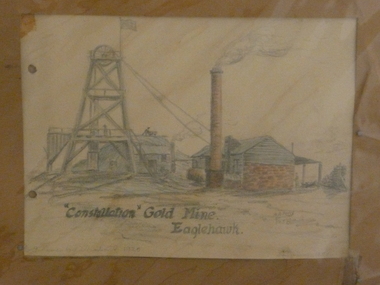
Painting - CONSTELLATION GOLD MINE EAGLEHAWK
Crayon artwork. Art shows poppet head with chimney and brick and timber engine house. Written on bottom ' Constellation Gold Mine, Eaglehawk. A.A. Perry 1958' Two punch holes on LH side. Written on back in pencil: This mine was west of the Victortia St railway gates on N side. I used to read the electricity meter here about 1918 - 20. This drawing was done from memory in 1958 when I was getting over a sickness'.eaglehawk, mining, constellation mine -
Bendigo Historical Society Inc.
Photograph - FORTUNA COLLECTION: COMET MINE
Black and white photograph. Image shows lattice work metal poppet head, with elevated tramway leading to poppet head. Mine chimney on RH side, building extreme right Number 31 written top centre.bendigo, mining, comet mine -
Bendigo Historical Society Inc.
Photograph - FORTUNA COLLECTION: HUSTLERS AND ENERGETIC MINE
Black and white photograph of mine site. Metal poppet head in centre, engine room buildings on LH side. Brick chimney extreme left. Large mullock/sand heap on RH side. Mine dam in foreground, three geese floating in water. In front of poppet head, horse drawn wooden cartbendigo, mining, hercules and energetic mine -
Bendigo Historical Society Inc.
Map - MINE LOCATION DRAWING AT VICTORIA HILL
Claims and shafts location for: Rae and co. - Noye and co. - Wittscheibe. Some additions to drawing made in pencil.mining, business -
Bendigo Historical Society Inc.
Photograph - FORTUNA COLLECTION: FORTUNA VILLA AND MINES
Black and white photograph ( copy) showing Lansell's Fortuna Villa in centre, lake in front. Elaborate gardens and steps leading to lake. On left hand side, mining chimney and elevated tramway leading to sheds. Large chimney on LH side. RH side of image: poppet head, tramways and mining chimneys (needle). Three poppet heads visible in background.bendigo, mining, fortuna mine sites