Showing 10388 items
matching plan
-
 Port Melbourne Historical & Preservation Society
Plan - Williamstown Road from Salmon Street to Prohasky Street, Engineering Department, Town of Port Melbourne, 1893 - 1919
Plan of Williamstown Road (Reconstruction of pitched portion). From Salmon Street to Prohasky Street. 1893 Loan Number 5.Reverse side - Williamstown Road, west of Salmon (Pitcher Construction).engineering - roads streets lanes and footpaths -
Clunes Museum
Plan - PLAN OF PROPOSED ADDITIONS TO THE CLUNES BUTTER FACTORY
HAND DRAWN PLANS IN BLACK AND RED INK ON GLASS PAPER WHICH IS PINNED WITH DRESSMAKER'S PINS TO BROWN PAPER BACKING SCALE: 1 INCH TO 1 FOOT VARIOUS NOTATIONS HANDWRITTEN INCLUDES "CREATED BY HARRY E SANDO C.E. SIGNED BY ABEL GOLDSWORTHY, CONTRACTOR AND HARRY E SANDO IN BLACK INK 1 DEC 1894clunes butter factory, commercial industry in clunes -
University of Melbourne, Burnley Campus Archives
Plan, Laidlaw & Laidlaw, Landscape Design Concept for Children's Garden, May 2010
landscape design, teaching material, laidlaw & laidlaw, children's garden, clifton hill primary school -
University of Melbourne, Burnley Campus Archives
Plan, Construction detail - Paving; Construction detail - Mower strip, 1990-2000
Coloured Plans for Courtyards at a hospital. Courtyards: 1,2 and 3; 4; 5; 6; Typical Courtyard Sections; Functional Areas.hospital, courtyard -
Bendigo Historical Society Inc.
Document - MARKS COLLECTION: PLAN OF MR. DENNIS'S MINE, NEW CHUM REEF
Mine plan drawn on heavy parchment paper. On top of plan 'Plan of workings for Mr. Dennis' Mine, New Chum Reef' Names on plan : Boundary line Koch & Hildebrandt; boundary line Bonati & Co. Signed on bottom (signature not clear) 14/9/72. -
Glen Eira Historical Society
Plan - Mount Scopus College, St. Kilda East
A copy of the amended Planning brief for the development of Mount Scopus College dated 24/10/1982. It includes a covering letter listing the amendments. The planning brief describes the school’s facilities, classrooms, playground and the planned development of the school. It includes a site plan and an architect’s illustration of the proposed development.mount scopus college, st. kilda east, city of caulfield, mayfield street, talbot avenue, floyd jeff, building permits, planning act, shaw house, m.m.b.w. planning scheme, classrooms, kindergarten, playgrounds, library, multipurpose hall, car parking, students, teachers, staff, secondary school, primary school, synagogue, architects, syman justin and bialek, site plan, hall, building development, education department, town and country planning board, brick, zoning, traffic, property, landscape planning, planting, fence -
University of Melbourne, Burnley Campus Archives
Plan, Royal Botanic Gardens Melbourne, 1978
Plan of RBG with grid references. Produced by Dept. of Crown Lands and Survey, Victoria, Division of Survey and Mapping. Prepared in 1978 from surveys completed in 1976. (1) 2 copies plan. Main areas, buildings, etc., labelled, beds outlined. (2) Original coloured plan and reduced size photocopy. More labelling, particularly beds (handwritten). Labelled Jeremy J. Wallace with handwritten notes on reverse re a project. (3) Reduced size photocopy. Handwritten labelling of beds. (4 - 11) Enlarged photocopies of sections of (1) Handwritten notes and plant labelling. (1). Photgraphed copies by FRESCO 510131-TA. (12) Plan on a grid, coloured. "No Public Access," areas marked.jeremy j. wallace, royal botanical gardens melbourne -
Port Melbourne Historical & Preservation Society
Plan - MMBW, Melbourne and Metropolitan Board of Works (MMBW), 1894 - 1895
Located on State Library Victoria (SLV) website by member Ray JelleyMelbourne Metropolitan Board of Works (MMBW) waste water (sewer) plans from 1894-95. Plan numbers 322, 331, 335, 564, 565, 575. Area bounded by Liardet St, East Esplanade, Foote St, Johns(t)on St and Hobsons Bay. Includes Gas works and Distillery.engineering - board of works, sewerage, mmbw, melbourne and metropolitan board of works -
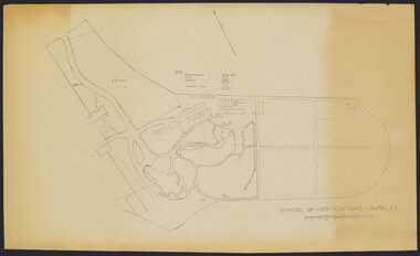 University of Melbourne, Burnley Campus Archives
Plan - Sketch, School of Horticulture - Burnley, 1957
A,B,C,E paper copies, D, tracing paper copy of plan. Hand drawn sketch of central area of grounds. Figures given for acreage of ornamentals, crops and grazing although only 1 acreage is shown on plan. (E) has further annotation. Scale 1 inch:40 ft.burnley gardens, ornmental, crops, grazing, burnley school of horticulture -
 Whitehorse Historical Society Inc.
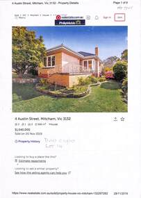
Document - Various including maps, titles, posters, Land ownership of 4 Austin Street, Mitcham, 1873 - 2019
Ownership history of 4 Austin Street, Mitcham.Ownership history of 4 Austin Street, Mitcham between 1873 to 2019, including the plan of the Mellorton Estate, Mitcham (1923), showing some lots priced at one hundred and forty-five pounds and the Charlesworth Estate ((1913). The Austin Street house was purchased by Martin and Shirley Gleeson 1956 and sold in 2019. Subdivision map of area south of Burnett Street to Harrison Street. non-fictionOwnership history of 4 Austin Street, Mitcham.drake real estate, charlesworth estate mitcham, mellorton estate mitcham, austin street mitcham no4, ainger frank -
 Bendigo Historical Society Inc.
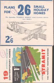
Magazine - Magazines and brochures
BHS Collection.Eight magazines and brochures. Titles are: Australian House and Garden book of Small Home plans, Best Homes, New horizons in houses, 19 Architect designed contemporary homes, 22 specially selected home plans, Plans for 26 small holiday homes, The Australian Women's weekly's home planning service 28 home plans and an advertising brochure for Daniel Robertson.Phillip Ellison name on several books, and the stamp of the State School No. 1008 Axedale on four others.homes, building -
Whitehorse Historical Society Inc.
Pamphlet, Keeping Blackburn Beautiful, 1984
Keeping Blackburn Beautiful, a planning scheme for Blackburn, a circular for residents soliciting comments for Advisory Committee, on a planning scheme.Keeping Blackburn Beautiful, a planning scheme for Blackburn, a circular for residents soliciting comments for Advisory Committee, on a planning scheme.Keeping Blackburn Beautiful, a planning scheme for Blackburn, a circular for residents soliciting comments for Advisory Committee, on a planning scheme.blackburn, advisory committee -
University of Melbourne, Burnley Campus Archives
Work on paper (item) - Student Work, Shane Furlong, Kneebone Habitat Landscape Design, 4th December, 2014
Created as an assignment for HORT90035, 'Landscape Construction and Graphics,' a subject at Burnley Horticultural College coordinated by Andrew Laidlaw. assignment, landscaping, burnley, 'landscape construction and graphics', hort90035, andrew laidlaw -
![Monnington [Estate], 1935](/media/collectors/550653872162f11fb04854aa/items/5907eb86d0ce0c14e82385c8/item-media/5907ecafd0ce0c14e823e87f/item-fit-380x285.jpg) Kew Historical Society Inc
Kew Historical Society IncPlan - Subdivision Plan, Monnington [Estate], 1935, 1935
Pru Sanderson, in her groundbreaking ‘City of Kew Urban Conservation Study : Volume 2 - Development History’ (1988), summarised the periods of urban development and subdivisions of land in Kew. The periods that she identified included 1845-1880, 1880-1893, 1893-1921, 1921-1933, 1933-1943, and Post-War Development. These periods were selected as they represented periods of rapid growth or decline in urban development. An obvious starting point for Sanderson’s groupings involved population growth and the associated economic cycles. These cycles also highlighted urban expansion onto land that was predominantly rural, although in other cases it represented the decline and breakup of large estates. A number of the plans in the Kew Historical Society’s collection can also be found in other collections, such as those of the State Library of Victoria and the Boroondara Library Service. A number are however unique to the collection.Subdivision plans are historically important documents used as evidence of the growth of suburbs in Australia. They frequently provide information about when the land was sold on which a built structure was subsequently constructed as well as evidence relating to surveyors and real estate and financial agents. The numerous subdivision plans in the Kew Historical Society's collection represent working documents, ranging from the initial sketches made in planning a subdivision to printed plans on which auctioneers or agents listed the prices for which individual lots were sold. In a number of cases, the reverse of a subdivision plan in the collection includes a photograph of a house that was also for sale by the agent. These photographs provide significant heritage information relating house design and decoration, fencing and household gardens.The first subdivision of Monnington took place in 1935. At that time, Monnington and 10 new allotments were offered for sale bordering Adeney and Marshall Avenues. In this subdivision plan, Monnington is one of 13 lots for sale. The subdivision created the irregular land holding of Monnington today. The excision of southwest corner of Monninton was caused by the need to have regular allotments facing the curve in Marshall Avenue.monnington - adeney avenue -- kew (vic.), subdivision plans -- kew (vic.) -
Whitehorse Historical Society Inc.
Article, City's Chief Executive Officer goes into retreat, 31/08/1988 12:00:00 AM
After five years as the City's Chief Executive Officer, Les Fell is to retire.After five years as the City's Chief Executive Officer, Les Fell is to retire. He looks back on his term with satisfaction, including his representation of Australia on the International City Management Association. He and his wife plan to run a seminar centre and executive retreat in Campaspe House, Woodend.After five years as the City's Chief Executive Officer, Les Fell is to retire. fell, les, fell, shirley, city of nunawading, local government -
 Melbourne Tram Museum
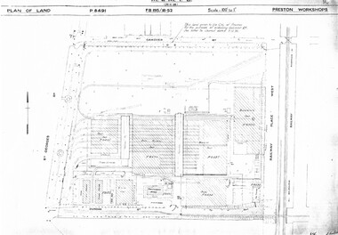
Drawing, Melbourne & Metropolitan Tramways Board (MMTB), "Preston Workshops", c1938
Set of nine photocopied plans or drawings on A3 sheets of the "Preston Workshops" - c1939 .1 - P8491 - Plan of land showing layout and associated drawings including Reservoir railway line - 19-4-1939. .2 - P8492 - Plan of Timber stacks and Hall - 3-2-1939 .3 - P8493 - Plan of Offices and location of sub-station - 13-12-1938 .4 - P8494 - Plan of Store including Oil store - c1939. .5 - P8495 - Plan of Paint Shop and relationship to timber stack - 1-3-1939 .6 - P8496 - Plan of Car building and Repairs shop - 6-12-1938 .7 - P8497 - Plan of machine shop - 10-12-1938 .8 - P8500 - Plan of Blacksmiths shop - 1-12-1938 .9 - P8590 - Plan of Substation - 1-12-1938trams, tramways, drawings, depots, property, preston workshops, workshops, substation -
Bendigo Historical Society Inc.
Plan - MARKS COLLECTION: PLAN FOR THE ADDITION OF A FOUR LEVEL STAIRCASE TOWER TO THE GARDEN ELEVATION OF FORTUNA VILLA FOR GEO. LANSELL ESQ
Plan for the addition of a four level staircase to the Garden Elevation of Fortuna Villa for George Lansell Esq. Plan shows: * Four levels of the staircase cobstructiob - Ground, Principal, First & Second levels of the staircase tower, with viewing walk at the second level * Entrance & garden elevations section showing exterior of the four level addition -
 Kew Historical Society Inc
Plan - Subdivision Plan, Eastlawn Estate, 1914
Subdivision plans are historically important documents used as evidence of the growth of suburbs in Australia. They frequently provide information about when the land was sold on which a built structure was subsequently constructed as well as evidence relating to surveyors and real estate and financial agents. The numerous subdivision plans in the Kew Historical Society's collection represent working documents, ranging from the initial sketches made in planning a subdivision to printed plans on which auctioneers or agents listed the prices for which individual lots were sold. In a number of cases, the reverse of a subdivision plan in the collection includes a photograph of a house that was also for sale by the agent. These photographs provide significant heritage information relating house design and decoration, fencing and household gardens.The ‘Eastlawn Estate’ was surveyed and ready for auction in March 1914, three months before the outbreak of World War I. Sixty-six allotments, created on the ‘order of Mr & Miss Preston’ surrounded the mansion of Woodlands in Harp Road. Woodlands formed part of the Estate, being advertised as lot 1. The allotments faced High, Station and Wright Streets, Harp and Normanby Roads, and Woodlands Avenue. Pru Sanderson in the Kew Conservation Study (Vol.2, 1988) wrote that the Eastlawn Estate ‘covered the western half of the failed Harp of Erin Estate’. Contemporary advertisements promoted the Eastlawn Estate as: ‘There will be no more convenient district nor pleasant Suburb than East Kew for the busy business man. When the Electric Tram is laid, he will be able to journey quickly and pleasantly direct from Collins Street to his home in the Eastlawn Estate in about 20 minutes’. The actual plans of subdivision were included in advertisements in The Argus and in the local newspapers.subdivision plans - east kew, eastlawn estate -
Ringwood and District Historical Society
Documents, 1997 Bushland Management Plans for BJ Hubbard Reserve, Wombolano Park, Loughie's Bushland, and weed control monitoring sheet
Five Bushland Management Documents 1. Bushland Reserve Management Plan 2. Weed Control Monitoring Sheet 3. BJ Hubbard Reserve - Bushland Management Plan 1997 4. Wombolano Park - Bushland Management Plan 1997 5. Loughie's Bushland Management Plan 1997 -
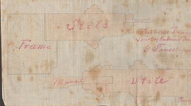 Bendigo Historical Society Inc.
Document - MARKS COLLECTION: DRAWING ENTRANCE DOOR FOR G. LANSELL
Plan drawn on waxed paper. Written on plan 'Full size Drawing of part of entrance door for G. Lansell, Esq' Plan shows line drawings of side elevations of Frame, Stile, Pelmet, Stile, Frame. On bottom of plan purple ink stamp 'Vahland & Getzschmann, Architects, Sandhurst'.Vahland & Getzschmann, Architects, Sandhurst.bendigo, house, fortuna villa -
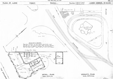 Melbourne Tram Museum
Drawing, Melbourne & Metropolitan Tramways Board (MMTB), "Candy Corner St Kilda", c1938
Set of two photocopied plans or drawings on A3 sheets of "Candy Corner St Kilda" .1 - P8427 - Plan showing locality plan, detail plan and adjacent buildings - 6-12-1938 .2 - ditto, but not the detail of the building in the centre of the island - "Green Knoll" Cafe and Amusement Park.trams, tramways, drawings, depots, property, candy corner, st kilda, turning loops -
Port Melbourne Historical & Preservation Society
Plan - Port Melbourne Yacht Club reconstruction, Taylor Howden Pty Ltd, Architects, c. 1990
Clubhouse burned 14 February 1990 and was rebuilt with volunteer labour over many years (opened 1998)Plan of Port Melbourne Yacht Club clubhouse reconstruction 1990 - pmyc, sketch of elevations of new clubhouse; faded almost to illegibilitybuilt environment - recreational facilities, societies clubs unions and other organisations, port melbourne yacht club, pmyc, taylor howden pty ltd -
Port Melbourne Historical & Preservation Society
Plan - Williamstown Road, Derham Street to Raglan Street, Port Melbourne, 14 Mar 1893
Plan of Williamstown road from Derham street to Raglan street. (67.1), together with written specification of works attached. (67.2), 1893.A.V. Heath (Town Surveyor). J.J. Bartlett (Mayor).engineering - roads streets lanes and footpaths, arthur victor heath, town clerks, james john bartlett, mayors -
Port Melbourne Historical & Preservation Society
Plan - Metalling and channelling Clark Street from Graham Street to Poolman Street, Engineering Department, Town of Port Melbourne, 14 Mar 1893
Plan for metalling channelling Clark Street from Graham Street to Poolman Street Loan Works 1893; relates to specification 96.1Signed by JJ Bartlett (Mayor)engineering - roads streets lanes and footpaths, arthur victor heath, town clerks, james john bartlett, mayors -
Port Melbourne Historical & Preservation Society
Plan - Port Melbourne, MMBW, 1987
Very large MMBW plan of Port Melbourne 1987 made up of several sections taped together; drains indicated in blackPMH&PS stamp on backengineering - canals and drainage, mmbw, melbourne and metropolitan board of works -
Port Melbourne Historical & Preservation Society
Plan - Sandridge, 1860
Original would have belonged to Joseph Turner, City Valuer 19th century and grandfather of member Ken Turner, who now holds original that he loaned to us for copying in 1998.Photocopy made from 1860 plan of Sandridge with proposals for various lots beyond the Lagoon, beyond the railway and even on the Railway Reservetown planning, built environment, joseph turner, land sales -
Clunes Museum
Plan - Map, Clunes Caravan Park Amenities Block
Four copies of draftsman plans for the amenities block at the Clunes Caravan Park, one copy has been amended with red penSigned by R. A. Boyd 12/71 Engineercaravan park, amenities upgrade -
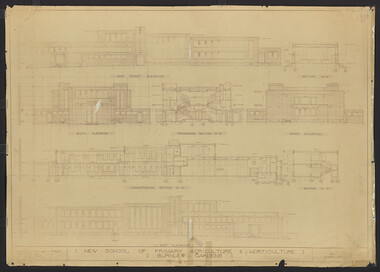 University of Melbourne, Burnley Campus Archives
Plan, New School of Primary Agriculture & Horticulture: Burnley Gardens, 1945
Original and photocopy of detailed architectural drawing and plan of new school by the Department of Public Works, Victoria Chief Architect, P. Everett.burnley school of horticulture, burnley gardens, percy everett -
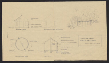 University of Melbourne, Burnley Campus Archives
Plan, G. Archer, Gazebo for Burnley Horticultural College, 1981
Plan for construction of Mudbrick Hut in the Native Garden - weekend workshop in 1981, drawn by G. Archer. Note final version is not round.native garden, mudbrick, g. archer -
University of Melbourne, Burnley Campus Archives
Plan - Student Work, D. Allen, Smith Residence - Back Yard: Concept, 07.06.2014
assignment, student work, landscape design