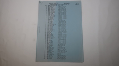
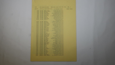
Showing 4247 items matching " prior"
-
 Melbourne Tram Museum
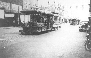
Photograph - Cable tram - Northcote terminus, 1930s
Photo of a cable tram set that has arrived at the Northcote line terminus in High St, prior to shunting. Another two cable sets are in the background. The gripman and conductor can be seen to be preparing to shunt the tram. The photo caption says the trailer is No. 235. A Bundy clock can been seen on the pavement on the left side of the photograph. A hairdresser and tobacconist shop are in the view. Photographer and date unknown.Yields information about Northcote cable tram terminus in High St at Dundas St.Black and white print with a hand written note on rear.In pencil "Car 235 at Dundas St"trams, tramways, northcote, high st, cable trams, tram 235, bundy clock -
 Melbourne Tram Museum
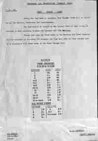
Document, Melbourne & Metropolitan Tramways Board (MMTB), "Fare Change cards", 12/1965
Notice to Drivers, conductors and conductresses titled "Fare Change cards" for reference for the period from 5/12/1965 to 13/2/1966. This followed an increase in fares and prior to the introduction of decimal currency on 14/2/1966. The card gives the revised fares for each section, and all night fares. Dated 15/11/1965 and signed by R C Drummond as Traffic Manager.Yields information about the fares prior to the introduction of decimal currency.Notice printed on quarto paper with a piece of paper glue to the base on the rear.tramways, fares, decimal conversion, conductors, crews -
 Ballarat Tramway Museum
Document, Electric Supply Co of Vic. (ESCo), "Instructions to Recruit Motormen", 1936
Single or front sheet of a set of notes titled "Instructions to Recruit Motormen", with a note that it was copied 10/2/1936 - has the heading of Electric Supply Co. of Vic. The document gives a description of the equipment fitted to a tram and its purpose. Most likely prepared for early ESCo tramcars, prior to the arrival of trams ex Melbourne. Only the first sheet of a multipage document has survived.Yields information and demonstrates ESCo information provided to motormen as part of their training.Single foolscap sheet, typed carbon copy.ballarat, trams, tramways, motormen, training, esco, equipment. -
 Melbourne Tram Museum
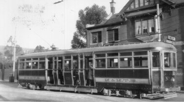
Photograph - L class 102 soon after commissioning, c1921
Photograph of L 106 soon after commissioning. Has the M&MTB on the side of the trams and four doorways as ordered by the PMTT. Prior to fitting the standard destination boxes and removing one of the doorways. Elsternwick Post Office in the background. See Keith's notes on the rear of the photograph for more information. See Reg Item 5251 for a better image from a copy negative. Printed on Kodak Paper.Yields infomation about L class tram 106, soon after its commissioning by the MMTBBlack and White Photograph with notes on the rear.On rear in ink a description - see image i2 and KSK number "S-A-133"trams, tramways, pmtt, l class, new tramcars, mmtb, tram 106 -
 Marysville & District Historical Society
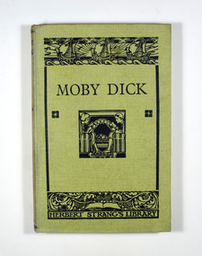
Book, Moby Dick
Moby Dick is the story of a man, a ship and a whale. It is a classic novel that was originally written in 1851.No dust cover. Front cover is light green. At the top of the cover is an illustration of three ships in black. Under the top illustration is the title of the book in black. In the center is an illustration of a boy and a girl sitting opposite each other, both reading books. At the foot of the cover is an illustration of an open book with a grape vine flowing across it. Underneath are the words 'Herbert Strang's Library in black. The title, author and publisher are in black on the spine.fictionMoby Dick is the story of a man, a ship and a whale. It is a classic novel that was originally written in 1851.moby dick, whale, whaling, whaling ship, herman melville, fiction -
 Mission to Seafarers Victoria
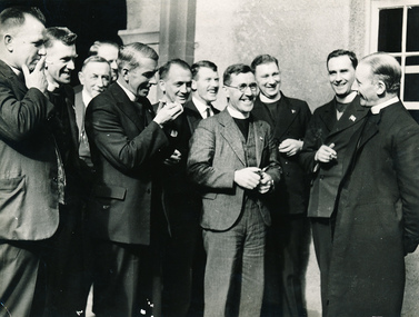
Photograph - Digital copy, Black and white, Herald Weekly Times, September 1936
This photograph was taken at the Triennial Congress, Melbourne. Frank Leslie Oliver served as chaplain at the Mission to Seafarers Melbourne for 30 years from 1930 - 1960. He is in this photograph, second from right, with a cigarette in his hand. Also in this photograph, at the far right, is the Most Reverend F. Head, Archbishop of Melbourne. The photograph is a record of a historic conference of MTS representatives from Australia and New Zealand. , September 1-3 , 1936: Revd Wm Hoog (Brisbane) Revd W.H. Terry (Port Pirie) Revd H.C Cuthbertson (Adelaide) Revd W.R. Tyler (Melbourne) Mr J.W. Neill (Melbourne) Revd. F. J. Evans (Sydney) Revd Frank L. Oliver ( Melbourne MTS) F W Melbourne (Archbishop F W Head 1929- 1942) Mr J.C. Grahame (Hobart) Rev B.J. Williams ((Wellington NZ) Rev J.C. Clift (Fremantle)Frank Leslie Oliver served as chaplain at the Mission to Seafarers Melbourne for 30 years from 1930 - 1960, including time served as chaplain with the Royal Australia Navy aboard HMAS Australia. He was a live-in chaplain and was supported by his entire family, including wife Moira, for whom a memorial window exists in the chapel. The Chaplains' Conference was held in 1936.Black and white photograph of a group of chaplains outside the Mission to Seafarers building in Flinders Street, Melbourne. Frank Oliver is second from right holding a cigarette in his right hand.Top left in blue ink (written by Padre Oliver): Australian MTS, Chaplains gathered in Triennal Congress, with most Rev.J Head, Abp of Melbourne. Top right corner in black ink: prior to 1939 In black and blue ink some names: Archbishop Head, Dad, Bill Tyler Port Melbourne, Padre Williams Wellington, Pat Neil Layreader Faded stamp in pink ink: Herald Feature Service, Melbourne A sticker with: Ret to B Kentroyal australian navy, mission to seafarers, anglican, frank leslie oliver, archbishop head, triennial conference, chaplains, herald newspaper, cigarette, robin kent, beverley kent nee oliver, chaplains conference, padre oliver, new zealand, pat neil, lay reader, bill tyler, port melbourne, reverend william wellington, chaplains group -
 The Beechworth Burke Museum
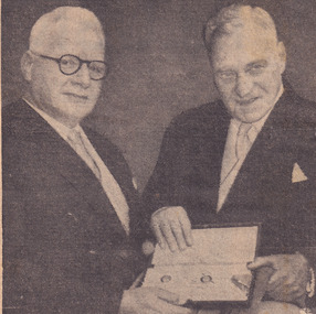
Newspaper - Photograph, c.1950
Taken in the 1950s, this picture is of two veterans of the First World War, Colonel Sir William Leggatt and Brigadier Sir Lionel Harris who fought together in France over 30 years prior. The two men were invested by the Queen at Buckingham palace as Knights, a prestigious honour for Australian soldiers, who for another 20 years would have no official recognition by the Australian government through the 'Order of Australia.' This image showcases the role of Australian service members who fought during the first world war being honoured by the British Government, personally meeting the Queen. Black and white photograph accompanied by text below taken from a NewspaperObverse: VICTORIA'S Agent-General, Colonel Sir William Leggatt (right) and his old / cobber's Brigadier Sir Lionel Harris, outside Buckingham Palace yesterday after hav- / ing received the accolade form the Queen. Thirty-two years ago as sergeant and private / they shared a trench in France. Yesterday as they waited to be knighted by the / Queen, Sir William said, "if anyone had told us then that we were ever going to / meet like this, we would have thought he was off his block. - Today's radiophoto / Reverse: 6539 (in pencil) / burke museum, beechworth, beechworth museum, world war one, military album, trenches, nighted, queen, buckingham palace, wwi, sir william leggatt, sir lionel harris -
 Kiewa Valley Historical Society
Book - Kiewa Voters' Roll, Shire of Bright - Voters' Roll 1979 - Kiewa Riding, 1979
Electoral rolls list people who are registered and eligible to vote at federal, state, territory & local government elections and referenda. Prior to 1990 the rolls list voters in alphabetical order by surnames & first names within each Sub division of an electoral division of each State or Territory. The roll is useful & interesting for family historians and the study of demographics. Alex McCullough lived in the Shire of Bright and was on its Council. Electoral roles help to locate the residential address of a person in a particular year or over a period of years. They can be used as a substitute for census records for family historians and the history of a particular place in this case the Kiewa Valley - Tawonga and Tawonga South.Approx. 60 pages of firm yellow paper with black typed print on one side only in 'landscape' format. Held by three staples. Each page has column - numbered 1 to 943; Surnames in alphabetical order; Given names; Occupation; includes L (=land). Address followed by Lot number and parish. Includes Tawonga and Tawonga SouthOn the cover on the right hand side handwritten and difficult to read - "Jack? / Indi / Benambra / Nth Eastern / Division? of Dawson / 123 Victoria Rd. / Melbourne 3000"shire of bright; kiewa riding; voters roll; alex mccullough; tawonga; tawonga south -
 Kiewa Valley Historical Society
Papers - Mt Beauty Voters' Roll, Shire of Bright - Voters' Roll 1985 - Mt Beauty, 4th July 1985
Electoral rolls list people who are registered and eligible to vote at federal, state, territory and local government elections and referenda. Prior to 1990 the rolls list voters in alphabetical order by surnames and first names within each Subdivision of an electoral division of each State or Territory. The roll is useful & interesting for family historians and the study of demographics. Alex McCullough lived in Mt Beauty and was a councillor for the Shire of Bright.Electoral Rolls help to locate the residential address of a person in a particular year or over a period of years. They can be used as a substitute for census records for family historians and the history of a particular place - in this case Mt Beauty.9 pages of firm blue paper with black typed print on one side only. Held at the top left corner with one staple. Each page has columns with 100 people listed up to 864 on page 9. surnames are in alphabetical order followed by given names and then addresses.shire of bright; voters' roll; alex mccullough; mt beauty -
 Kiewa Valley Historical Society
Papers - Kiewa Riding Voters' Roll, Shire of Bright - Voters'Rolls 1985 (May and June) - Kiewa Riding, 4th July 1985
Electoral rolls list people who are registered & eligible to vote at federal, state, territory & local government elections & referenda. Prior to 1990 the rolls list voters in alphabetical order by surname & first names within each subdivision of an electoral division of each state or territory. The roll is useful and interesting for family historians & the study of demographics. Alex McCullough lived in Mt Beauty and was a councillor for the Shire of Bright.Electoral Rolls help to locate the residential address of a person in a particular year or over a period of years. They can be used as a substitute for census records for family historians and the history of a particular place - in this case Tawonga, Tawonga South, Falls CreekMay 1985 is 7 pages; June 1985 is 9 pages of firm yellow paper with black typed print on one side only. Held by one staple at the top left hand corner. The May 1985 - Each page has columns with 100 people listed up to 628 on page 7. Surnames are in alphabetical order followed by given names and then address. June 1985 Voters Roll (Non resident) is created from Property & lists Voters No. (up to 406) Property No. Name (alphabetical) & address and are non resident voters.shire of bright; voters' rolls; kiewa riding; tawonga; tawonga south; alex mccullough; falls creek -
 Warrnambool and District Historical Society Inc.
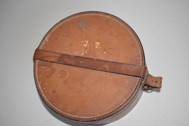
Collars and box
Detachable collars enclosed in a leather box such as this one were used in the 19th and early 20th centuries, particularly by men in the business and clerical professions. The collars were attached by studs or buttons to a shirt. The collars were removed prior to shirt washing the shirt. The leather box was most useful for travelling. Detachable collars could still be used today particularly by clergymen. Two are named E R Twomey.This box and collars are retained as an example of vintage men's wear. It will be useful for display.A brown leather cylindrical case with a strap and buckle. It has white thread stitching around the rim and upper edge of the lid, the slot for the buckle, the rim and lower edge of the base . Inside are four detachable white winged collars for wearing with a shirt. Each has three holes, one for a button and two for a stud or for buttons at the front, two wings and a curved slot at the back.They are made of very fine cotton and linen.002215.1 J.T. MADE IN ENGLAND ESPECIALLY FOR Buckley & Nunn Ltd. MELBOURNE 002215.2 A stamped lion, WELCH MARCETSON 7 CO. LTD. 4 THE ALATUS TRADE MARK DES M 9 M 520 1 3/4 x 1/2 T14 002215.3 MADE IN ENGLAND FOR BUCKLEY & NUNN MELBOURNE EXTRA QUALITY , A deer head with antlers in a pointed elipse E.R. THOMEY a red inverted drawn triangle two dots Lindum 2x 151/2 002215.4 MADE IN ENGLAND FOR BUCKLEY & NUNN MELBOURNE EXTRA QUALITY, A Deer head with antlers in a pointed elipse . T indecipherable . E.R.T.4 indecipherable. Lindum 2x15 002215.5 E.R. THOMEY Indecipherable Lindum 2x 15 ? warrnambool, detachable vintage collars, detachable men's shirt collars -
 Eltham District Historical Society Inc
Certificate, Shire of Eltham: Presented to Pte. George Melville Balfour, VX6104, 1 August 1942
Certificate of appreciation presented to Private George Melville Balfour, VX6104, for voluntary enlistment for active service overseas. Prior to the war, George Balfour lived at Wangakeirra(?), Kangaroo Ground. Post war, he lived at Lavender Park, Eltham. He served in the 2/8 Batallion, AIF, in North Africa and taken prisoner of war in Greece. In the UK post May 1945 and in Australia December 1949. Never married.Colour photocopy 33 x 24 cm of a certificate 2/8 battallion, aif, certiificate, cr. a. brinkkotter, cr. price, eltham, george melville balfour, lavender park, prisoner of war, second word war, shire of eltham, vx6104 -
 Bendigo Military Museum
Document - ASSOCIATION PROPOSAL, September 1982
A copy of the proposal to form the No 44 (Rhodesia) Squadron RAF was sent to F.G. Davey. Davey flew with this squadron during WW2. The proposal gives a brief outline of the squadrons role at the time of the Falklands War and at the time of its disbandment. Davey was not involved with the association as he had passed away in 1975, prior to it being formed. Part of the F.G. Davey Collection. See catalogue no, 3536P for his service record.Two page document on cream coloured paper. Pages are stapled in the top left hand corner with a copper coloured metal staple. Text is printed in black type. Page one had printing on both sides. Page two is a proforma with printing on one side only.no44 (rhodesia) squadron, f.g. davey -
 Ballarat Clarendon College
Book, Eight books of various titles and sizes
Presented to the school library by staff member Major A G (Gordon) S Edgar. Gordon was the Ballarat College and then Ballarat Clarendon College bursar 1959-1979 . The first six books were donated to the ballarat College library just prior to amalgamation Clarendon Presbyterian Ladies College. The second two books were donated to ballarat Clarendon College after Major Edgar had left the school's employ. Example of ongoing community support of the schoolEight large books of various titles, sizes and bindingsBook plate inside of six books : Crest / Ballarat College / Library / Presented by / Major Edgar / May 1973... Book plate inside of two books : Crest / Ballarat & Clarendon College / Library / Presented by / Major A G Edgar / 29th May 1981....major-gordon-edgar, ballarat-college, library, ballarat-clarendon-college -
 City of Moorabbin Historical Society (Operating the Box Cottage Museum)
Lights, candle snuff, c1900
A candle snuffer is an instrument used to extinguish burning candles. This is accomplished by smothering the flame with a small metal cup that is suspended from a long handle, and thus depriving it of oxygen. The use of a candle snuffer helps to avoid problems associated with blowing hot wax. Candle snuffers are still commonly used Churches. Prior to the introduction of gas and electricity, candles and kerosene lamps were used for lighting in households after sunsetEvery Early settlers depended on candlelight after sunset and candle snuffs were a safe, clean and efficient way to extinguish the candle flameThis candle snuff has a brass handle with a turned polished wood tip. The brass cup, that is placed over the flame to extinguish it, is decorated with an engraved brass moth.early settlers, pioneers, moorabbin, bentleigh, ormond, market gardeners, lights, lamps, candles -
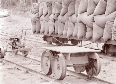 Puffing Billy Railway
C2N Type Trolly - Former Victorian Railways Gauge 2'6", circa 1910
This type of trolly is known to date from prior to 1910 and were in use before petrol engines were used to transport workmen along the railway lines. The exhibit was located at Colac in 1961, after being used on the Colac to Beech Forest and Crowes narrow gauge railway. This type of trolly was built in two versions; one for the Victorian Railways broad gauge lines, and one for the narrow gauge lines.Historic - Victorian Railways narrow gauge - track work vehicle. This vehicle was used in the days before petrol engines were used to drive vehicles transporting workmen along the railway line.C2N Type Trolly - Victorian Railways Gauge 2'6" Trolly Has a flat piece of wood that you would stand on with four metal wheels, one under each corner.c2n, trolley, victorian railways, hand power, narrow gauge, puffing billy, trolly -
Stawell Historical Society Inc
Photograph, Students of Pleasant Creek Training Centre 1950's
Bob Smith, Gordon Prior, Bill Kelly, Kath Delahunty, Margaret Forsyth, Peter Woods, Matron Carter, Matt Lynch, Miss Burnside, Ira Carter, Smart, Haywood, Irene Peters, John Scarlatti, Mavis Taylor, Brian Winks, Ray Squire, Lillian Haughton, Maureen Karline, Brian Siggins, Ken Thompson, Lindsay Thompson, Arthur Young, Brian Clugson, Bev Berry Students and Staff at Pleasant Creek Training Centre late 1950'seducation, students -
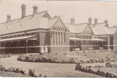 Sunbury Family History and Heritage Society Inc.
Photograph, Male Hospital Sunbury
The Male Hospital in Sunbury was one of the buildings that was within the grounds of the Sunbury Mental Hospital, later known as the Sunbury Asylum, that opened on 1st December 1879 on She-oak Hill ( Jacksons Hill). Patients and staff from the Ballarat Asylum were transferred there. Prior to the establishment of the Asylum, the Sunbury Industrial School occupied the site from 1865. The Sunbury Asylum, later known as Caloola, continued to operate until the 1992.The Sunbury Mental Hospital was an important institution and was the main source of employment for Sunbury residents for 120 years. It was also one of a number of similar institutions that were established around Melbourne's outer rural centres.A sepia non- digital photo in post card format of a hospital building with verandahs along a section of the front and down the side. Two nurses are standing in front. There are circular garden beds in from of the building. A message dated 23/11.09 from Gregor to Cookie has been written on the back of the card.MALE HOSPITAL/SUNBURYsunbury mental hospital, sunbury asylum, caloola, the hill -
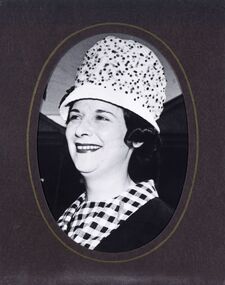
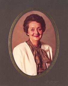
 City of Greater Bendigo - Civic Collection
Photograph - Portrait, Martin Washington, Gwen Jeffrey, Mayoress 1969 - 70, c 1969
Prior to the election of female Councillors and Mayors in the 1960’s, the Lady Mayoress role was one of the few ways women could officially undertake civic duties. Mayoresses made important contributions to their local communities through their charity work and as ambassadors for their region on a state and federal level. They also undertook some Mayoral duties on occasions when their husband was unavailable. Gwen Jeffrey served as Mayoress from 1969 - 70.Reproduction of Black and White photographic studio portrait sitting behind oval mount.lr; Martin Washingtoncity of bendigo mayoress, city of greater bendigo portraits, city of bendigo mayor, mayor jeffrey, mayoress jeffrey, lansell pendant -
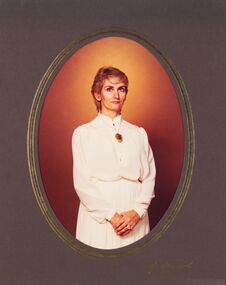
 City of Greater Bendigo - Civic Collection
Photograph - Portrait, Peg Elliott, Mayoress 1971 - 72, c 1971
Prior to the election of female Councillors and Mayors in the 1960’s, the Lady Mayoress role was one of the few ways women could officially undertake civic duties. Mayoresses made important contributions to their local communities through their charity work and as ambassadors for their region on a state and federal level. They also undertook some Mayoral duties on occasions when their husband was unavailable. Peg Elliott served as Mayoress from 1971 - 72.Black and White photographic portrait sitting behind oval mount.lr; Martin Washingtonstudio photography, city of bendigo mayoress, city of greater bendigo portraits, city of bendigo mayor, elliott collection, mayor d elliott, mayoress p elliot, lansell pendant -
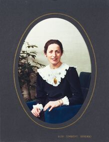
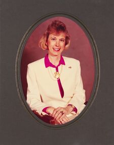
 City of Greater Bendigo - Civic Collection
Photograph - Portrait, Don Semmens, Kathy Tomkinson, Mayoress, 1980 - 81, c 1980
Prior to the election of female Councillors and Mayors in the 1960’s, the Lady Mayoress role was one of the few ways women could officially undertake civic duties. Mayoresses made important contributions to their local communities through their charity work and as ambassadors for their region on a state and federal level. They also undertook some Mayoral duties on occasions when their husband was unavailable. Kathy Tomkinson served as Mayoress from 1980 - 81.Colour photographic studio portrait sitting behind oval mount.Inside lr; Don Semmens / Bendigocity of bendigo mayoress, city of bendigo mayor, mayoress tomkinson, mayor tomkinson, lansell pendant -
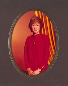
 City of Greater Bendigo - Civic Collection
Photograph - Portrait, Don Semmens, Elizabeth Stoltz Mayoress 1981 - 82, c 1981
Prior to the election of female Councillors and Mayors in the 1960’s, the Lady Mayoress role was one of the few ways women could officially undertake civic duties. Mayoresses made important contributions to their local communities through their charity work and as ambassadors for their region on a state and federal level. They also undertook some Mayoral duties on occasions when their husband was unavailable. Elizabeth Stolz served as Mayoress from 1981 - 82.Black and White photographic portrait sitting behind oval mount.lr; Don Semmens Bendigocity of bendigo mayoress, city of greater bendigo portraits, city of bendigo mayor, lansell pendant, mayoress stoltz, mayor stotz -
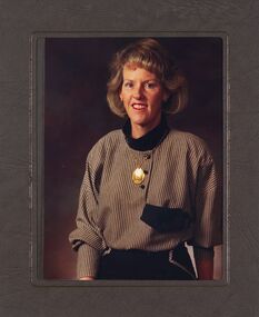
 City of Greater Bendigo - Civic Collection
Photograph - Portrait, H. Hampel, Judith Mansell, Mayoress 1983 - 84, c 1983
Prior to the election of female Councillors and Mayors in the 1960’s, the Lady Mayoress role was one of the few ways women could officially undertake civic duties. Mayoresses made important contributions to their local communities through their charity work and as ambassadors for their region on a state and federal level. They also undertook some Mayoral duties on occasions when their husband was unavailable. Judith Mansell served as Mayoress from 1983 - 84.Colour photographic portrait sitting behind oval mount.lr; H. Hampelcity of bendigo mayoress, city of greater bendigo portraits, city of bendigo mayor, lansell pendant, mayor mansell, mayoress mansell -
 City of Greater Bendigo - Civic Collection
Photograph - Portrait, H. Hampel, Gloria Quin, Mayoress 1985 - 86, c 1985
Prior to the election of female Councillors and Mayors in the 1960’s, the Lady Mayoress role was one of the few ways women could officially undertake civic duties. Mayoresses made important contributions to their local communities through their charity work and as ambassadors for their region on a state and federal level. They also undertook some Mayoral duties on occasions when their husband was unavailable. Gloria Quin was Mayoress from 1985 - 86.Colour photographic portrait sitting behind oval mount.lr; H. Hampelcity of bendigo mayoress, city of greater bendigo portraits, city of bendigo mayor, lansell pendant, mayor quin, mayoress quin -
 City of Greater Bendigo - Civic Collection
Photograph - Portrait, Helene Currie Mayoress 1986 - 87, c 1986
Prior to the election of female Councillors and Mayors in the 1960’s, the Lady Mayoress role was one of the few ways women could officially undertake civic duties. Mayoresses made important contributions to their local communities through their charity work and as ambassadors for their region on a state and federal level. They also undertook some Mayoral duties on occasions when their husband was unavailable. Gloria Quin was Mayoress from 1985 - 86.Colour photographic portrait sitting behind oval mount.city of bendigo mayoress, city of greater bendigo portraits, city of bendigo mayor, lansell pendant, mayor currie, mayoress currie -
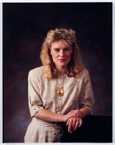
 City of Greater Bendigo - Civic Collection
Photograph - Portrait, Noela Nankervis, Mayoress 1985 - 86, c 1985
Prior to the election of female Councillors and Mayors in the 1960’s, the Lady Mayoress role was one of the few ways women could officially undertake civic duties. Mayoresses made important contributions to their local communities through their charity work and as ambassadors for their region on a state and federal level. They also undertook some Mayoral duties on occasions when their husband was unavailable. Noela Nankervis served as Mayoress from 1987 - 88.Colour photographic portrait sitting behind oval mount.city of bendigo mayoress, city of greater bendigo portraits, city of bendigo mayor, lansell pendant, mayor nankervis, mayoress nankervis -
 City of Greater Bendigo - Civic Collection
Photograph - Portrait, Richard Gibbs, Elizabeth Morley, Mayoress 1989 - 90, c 1989
Prior to the election of female Councillors and Mayors in the 1960’s, the Lady Mayoress role was one of the few ways women could officially undertake civic duties. Mayoresses made important contributions to their local communities through their charity work and as ambassadors for their region on a state and federal level. They also undertook some Mayoral duties on occasions when their husband was unavailable. Elizabeth Morley served as Mayoress from 1989 - 90.Colour photographic portrait sitting behind oval mount.Front cover; Photograph by: / Richard Gibbs / Tel: (054)413411city of bendigo mayoress, city of greater bendigo portraits, city of bendigo mayor, lansell pendant, mayor morley, mayoress morley -
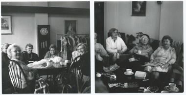 Melbourne Legacy
Photograph, Widows activities, 1987
Two photos of Legacy Widows Club gathering at Legacy House for craft group in 1987. It shows one of many activities that the widows were involved in. For many years there were workshops for craft and others for painting. The timetable for activities was published in The Answer (prior to Sept 1992 it was called the Melbourne Legacy Widows' Newsletter) each month. These regular meetings and workshops provided important opportunities for widows to meet, socialise and be active.A record of the type of activities Legacy provided as a social outlet for the widows.Colour photo a widows during craft meeting at Legacy House.widows, craft, activities -
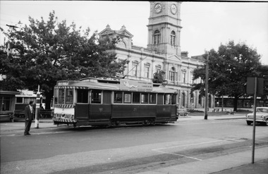 Ballarat Tramway Museum
Photograph - Digital image Set of 2 - tram 21, Graham Parry, 1971
Photographed inn Ballarat during 1971 prior to closure of the system by Graham Parry. All images from the scanned negative. .1 - tram 21 at the city terminus, Sturt St, with a Lydiard St North destination and a Twin Lakes sign. In the background is another tram on the other side of the road, the short tram stop pole and the Town Hall. .2 - ditto taken from the Post Office steps.Yields information about the Mt Pleasant terminus and tram operations in 1971.Set of two digital images of photograph of tramstrams, tramways, sturt st, lydiard st north, town hall, tram 21 -
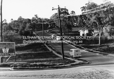 Eltham District Historical Society Inc
Photograph, R.J. Manuell, Sherbourne Rise, Briar Hill, c.1964
Sherbourne Rise Estate, looking up Woodland Grove from Calrossie Avenue, Briar Hill. The house is believed to be No. 8. This is prior to Regal Court being established off Woodland Grove. View of Squires land which was subdivided for housing - two parts Woodland Crest higher part off Woodland Grove and Calrossi Avenue, Briar Hill showing new roads with curb and channelling and footpaths. No date.Black and white photograph printed with white bordersVerso: COO2briar hill, real estate, woodland grove, squires, roads, sherbourne rise estate