Showing 10723 items
matching sites
-
 Bendigo Historical Society Inc.
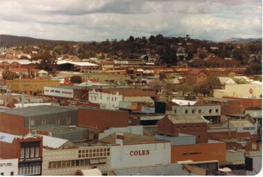
Photograph - VIEW FROM OLD BENDIGO POST OFFICE CLOCK TOWER LOOKING SOUTHWEST TOWARDS QUARRY HILL
View from old Bendigo Post Office Clock Tower South West in the direction of Quarry Hill. Names that appear on buildings are Coles, McCalmans, Bolton printers, New World Supermarket, Hopetoun hotel Target, and above these show buildings on the Bendigo Railway Station site.bendigo, history, buildings/streetscapes, coles, mccalmans, printers (boltons), new world supermarket, target, hopetoun hotel, and railway yards and buildings. -
 Bendigo Historical Society Inc.
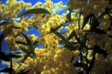
Slide - RALPH BIRRELL COLLECTION: EIG SCHOOL, c1966
EIG School - Ralph Birrell Collection. - Construction of Latrobe Uni. C1966. Bendigo Institute of Technology, Engineering School, Applied Science. Close up off wattle growing on the Latrobe University site. C1988. Markings In black 20 SEP 66M8.. In yellow Made in Australia.Kodakeducation, tertiary, latrobe university bendigo, eig school - ralph birrell collection. - construction latrobe uni. c1966. bendigo institute of technology, engineering school, applied science. wattle growing latrobe university. c1988. -
 Port Melbourne Historical & Preservation Society
Photograph - Various reserves, Port Melbourne, Ron Laing, 1986 - 1999
Part of Ron Laing's collection of photographs recording Port Melbourne over a thirteen year period. Donated to the PMH&PS by the photographer.A set of 42 colour photographs of the various reserves including Garden City Reserve, West Gate Park and ibis, Boulevard and site from Webb Dock, new Evans Street gardens on the old railway sidings, and panorama looking east from Webb Dock. 1990sbuilt environment, natural environment, parks and gardens, ron laing -
Port Melbourne Historical & Preservation Society
Plan - Port Melbourne Yacht Club, John Adam, Architect, 1960s
Plans for Port Melbourne Yacht Club new dinghy building 1962. .01 Storage layouts - sketch plan .02 Plan of new dinghy building .03 Location and pile plan .04 Working drawing - site elevations .05 Working drawing - plan view sport - yachting, built environment - recreational facilities -
 Bendigo Historical Society Inc.
Photograph - HARGREAVES STREET BENDIGO
Copy of black and white photograph. Image taken from Hargreaves Street, looking towards the Jewish Synagogue. Warren's Timber yard in foreground. Copy of research on site of synagogue, two letters written in 1855, to the Surveyor General Melbourne and one to G. Stanker (?) (name indecipherable)bendigo, streetscape, hargreaves street, jewish, synagogue, warren's timber yard -
Bendigo Historical Society Inc.
Newspaper - VICTORIA HILL - SITE FOR MINE MUSEUM
Newspaper article and photo from the Bendigo Advertiser dated 12/7/68. Article mentions Victoria Hill, behind John Brown Industries Factory, will be the site for the mining and historical museum. Photo shows two visitors looking at the open cut area of Victoria Hill.newspaper, bendigo advertiser, victoria hill, victoria hill, site for mine museum, john brown industries, bendigo city council, bendigo and district association, cr t r flood, victoria quartz gold mine, lansell's 180 mine, theodore ballerstedt, mr george lansell, heather champness, shirley leersen -
 Wangaratta RSL Sub Branch
Photograph - Photographs
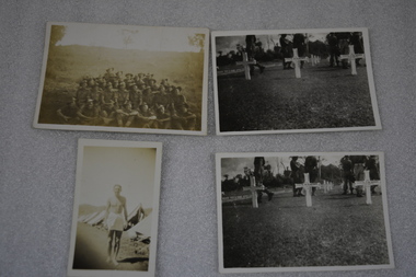
Photographs located in personal items belonging to John Brian MURRAY VX142238 - Photograph of three crosses taken at Bomana Cemetery in Port Moresby where the following servicemen are buried: - Thomas Rutherford HOPE VX141789 born 8/12/1919 at Footscray served with the 57/60 Australian Infantry Battalion and died of wounds on 22/6/1945 at Bougainville; Maxwell FISHER VX149937 born 23/6/1911 at Wangaratta/Carboor - Acting Sergeant with the Australian Army Catering Corp attached to the 58/59 Australian Infantry Battalion and died of wounds on 17/6/45 at Bougainville; and Thomas Martin BROWN WX16690 born 19/4/1916 at Fremantle - Trooper with 2/4 Armoured Regiment attached 24th Infantry Battalion and Killed in Action on 28/4/1945 at Bougainville.Four small black and white unframed photographs 1. Male standing with white towel around waist in front of row of tents 2. Group of soldiers with hill in background 3&4 Identical photographs - three white grave crosses with soldiers behind. Grave sites of j b murray vx142238, thomas rutherford hope, maxwell fisher, thomas martiin brown, bomana cemetery port moresby, ww2, new guinea -
Tatura Irrigation & Wartime Camps Museum
Document, Stefan Asboth and Arthur Knee, Camp 1 Tatura site inspection with Stefan Asboth May 28th 1989, May 28th 1989
Stefan Asboth retraced with Arthur Knee, the campsite and memories of the former, who was interned at Camp 1A clear plastic folder with a dark blue margin with white paper insert. Pale blue back cover. On the top right hand corner is a white self adhesive label on which is printed "Camp 1 Tatura site inspection with Stefan Asboth May 28th 1989"As abovecamp 1 tatura -
Whitehorse Historical Society Inc.
Article, Blackburn and Mitcham Shire & Mitcham Choral Society, 1925, 1928, 1935
Three articles from the reporter concerning the new Shire of Blackburn and Mitcham, 11 Sep 1925, 16 Sep 1925 re the site of the new Municipal hall and 7 Dec 1928, also an article in the age about Mitcham Choral Society, 5 Aug 1935.Three articles from the reporter concerning the new Shire of Blackburn and Mitcham, 11 Sep 1925, 16 Sep 1925 re the site of the new Municipal hall and 7 Dec 1928, also an article in the age about Mitcham Choral Society, 5 Aug 1935.Three articles from the reporter concerning the new Shire of Blackburn and Mitcham, 11 Sep 1925, 16 Sep 1925 re the site of the new Municipal hall and 7 Dec 1928, also an article in the age about Mitcham Choral Society, 5 Aug 1935.local government, shire of blackburn and mitcham, mitcham choral and orchestral society, municipal offices -
Whitehorse Historical Society Inc.
Article, Searching for proof
Financial documents from Heatherdale Primary School could contain information affecting future Council decisions regarding the school site.Financial documents from Heatherdale Primary School could contain information affecting future Council decisions regarding the school site. They might prove that Mitcham community was a major contributor to at least two buildings at the school. A search is being made in the school storage area for the documents.Financial documents from Heatherdale Primary School could contain information affecting future Council decisions regarding the school site.primary schools, heatherdale primary school, bushby, sue, middleton, jennifer -
Whitehorse Historical Society Inc.
Document, History of Burwood East State School No. 454, 1969
First School Established 1861, a non vested school Harkaway No. 184 on the present school site opened with twenty pupils who paid a fee of 6d a week. Changed name to Common School No. 454 in 1864 and became No. 454 Burwood East State School on 1902.burwood east state school no. 454, harkaway school, tally ho, wood, helen e., bennett, r.h. -
 Whitehorse Historical Society Inc.
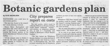
Newspaper - Article, Botanic Gardens Plan, 25/11/1998
Two articles in the Whitehorse Gazette and Whitehorse Post on the possibility of setting up a botanic garden on the site of the Whitehorse City's 'Bicentennial Orchard' situated between Hawthorn Road and Jolimont Road. Whitehorse Council have called for a feasibility report from an operational and financial point of view..parks and reserves, bicentennial orchard, hawthorn road, forest hill, jolimont road, springvale road -
 Ballarat Tramway Museum
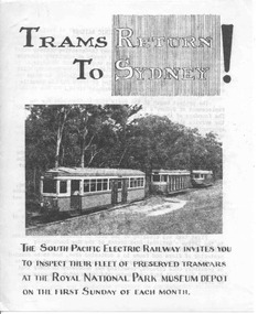
Pamphlet, South Pacific Electric Railway, "Trams Return to Sydney", 1961
Folded foolscap sheet, printed, titled "Trams Return to Sydney", with a photo of three trams on the Royal Park line at Loftus, c1961, prior to actual operation of the trams. Provides notes on the site, SPER, progress and plans. On rear has a plan of the area relative to Sutherland station.trams, tramways, sper, sydney trams -
University of Melbourne, Burnley Campus Archives
Work on paper (item) - Student Work, Lucas McGarrigle, Landscape Design Plan, 2018
Made as an assignment for HORT90035, a subject at Burnley Horticultural College coordinated by Andrew Laidlaw. assignment, landscaping, burnley horticultural college, landscape construction and graphics, hort90035 -
Canterbury History Group
Ephemera - 5 Scott Street Canterbury, 2001
Real estate advertisement for the sale by auction of 5 Scott Street Canterbury on Saturday 26 May 2001. Includes a coloured photograph of the exterior of the house and Maling Road, and a floor and site plan. A note on the flyer by Robin Kelly reports that the property was sold for $486, 500 in 2001canterbury, scott street, theatre place, maling road -
Canterbury History Group
Ephemera - Inspirational harmony, [2002]
Real estate advertisement for the sale by auction of 2a Golding Street Canterbury on Saturday 8 May [2002]. Includes coloured photographs of the interior and exterior of the house and floor and site plans. Flyer has sold sticker and Robin Kelly has noterd the price as $795, 000.canterbury, golding street -
 Ringwood and District Historical Society
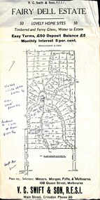
Flyer, Residential Land Sale Sub-division - Fairy Dell Estate, Warranwood, Vic. - circa 1950s
Land sale advertisement for 50 home sites with map of Sub-division showing layout of streets and allotments, summary of local features and services and terms of sale, and copy of sectional map of Crown Allotments 20 & 21B Parish of Warrandyte also showing layout of Sub-division.Subdivision includes Grandview Grove (later Bemboka Road), Merrill Crescent and Kerry Road, Warranwood. Estate Agents - V.C. Swift & Son R.E.S.I., Main Street, Croydon, Phone 20. Solicitors - Morgan, Fyffe & Mulkearns, 108 Queen Street, Melbourne. Handwritten 1970s real estate price notations for some blocks. -
 Bendigo Historical Society Inc.
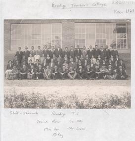
Photograph - LA TROBE UNIVERSITY BENDIGO COLLECTION: BENDIGO TEACHERS' COLLEGE STAFF AND STUDENTS
A black and white photograph of the staff and students of Bendigo Teachers' College in the year 1929. They are unnamed except Miss Dot McKay and Mr. Scott second row in the centre. The photograph is taken in front of the Court House which was the second site for Bendigo Teachers' College. See 3320.100bendigo, education, bendigo teachers' college, la trobe university bendigo collection, collection, bendigo, bendigo teachers' college, education, tertiary education, teacher training, photo, photograph, photographs, photography, history, teaching, miss j.c. burnett, mr. geoff pryor, d. mckay, t.f. scott -
 Bendigo Historical Society Inc.
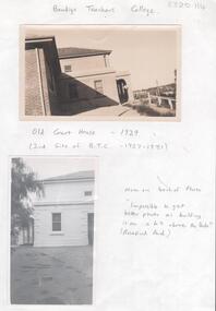
Photograph - LA TROBE UNIVERSITY BENDIGO COLLECTION: OLD COURT HOUSE BENDIGO
Two black and white photos of the Old Court House in the year 1929. This was the second site of the Bendigo Teachers' College from 1927 - 1931. Note on the back of the second photo 'Impossible to get better photo as building is on a hill above the Park'. (Rosalind Park.) See 3320.100bendigo, education, old courthouse, la trobe university bendigo collection, collection, bendigo, education, bendigo teachers' college, tertiary education, teacher training, photo, photos, photograph, photographs, photography, court house bendigo, old court house bendigo, miss j.c. burnett, mr. geoff. pryor, building, buildings, place, site, courthouse, old courthouse -
 Lakes Entrance Historical Society
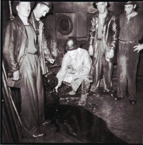
Photograph - Oil Industry, H D Bulmer, 1945
Also six black and white photographs showing activities and machinery in workroom of Lakes Oil Limited deep shaft Lakes Entrance 05322.1, .2, .3, .4, .5, .6 All 17 x 17 cmBlack and white photograph showing Mr Demaine Manager Director of Lakes Oil Limited with his hand in the oil flow with four workmen in the workrooms of the oil shaft. Plus six black and white photographs of operations at same oil well site Lakes Entrance Victoriaoil and gas industry -
 Flagstaff Hill Maritime Museum and Village
Functional object - Cow Bell, Circa 1878
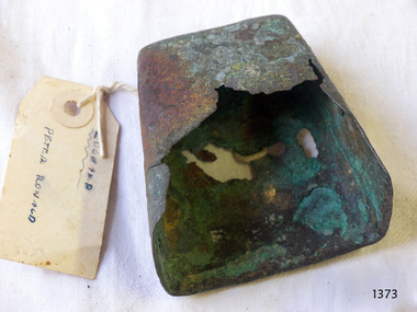
The artefact is a damaged brass cow bell recovered from the 1878 shipwreck of the LOCH ARD near Port Campbell. It was raised by Flagstaff Hill divers in 1973 and is in storage at the Maritime Village. The LOCH ARD was constructed on the Clyde in 1873 for the prestigious Loch Line of colonial clipper ships, designed for the Australian run. She sailed from England on 1 March 1878 carrying 37 crew, 17 passengers and a diverse general cargo ranging from luxury items to bulk railway iron. On 1 June 1878, emerging from fog and hearing too late the sound of breakers against the tall limestone cliffs, the vessel struck the southern foot of Mutton Bird Island and sank in 23 metres of water. Of the fifty-four people on board only two survived, one young male crewman and one young female passenger. A century later, despite the pounding seas and the efforts of looters, the wreck site continued to provide ample evidence of the extraordinary range of goods being imported into the Colony of Victoria in the post-Gold Rush era. Flagstaff Hill divers in the 1970s reported finds of “Bottles of champagne, window panes, rolls of zinc, barrels of cement, iron rails, clocks, lead shot, corrugated iron, lead, marble, salad oil bottles, ink bottles, copper wire, gin bottles, rolls of carpet, floor tiles, copper rivets, gas light fittings, pocket knives, toys, crystal chandeliers, beer mugs, cutlery, candles sticks, wick scissors, cow bells, and sauce bottles.” From this array of objects on the ocean floor emerged the humble brass cow bell. Cow bells were common to colonial agriculture and transport, used wherever animals were turned out to graze overnight and had to be rounded up again next morning. Bells were fastened around the necks of household milking cows, domestic goats, bullock teams, horse teams, and camel teams, to help find them in the pre-dawn light. Station shepherds and cattle drovers also used them to warn of any disturbances to their flocks and herds overnight. The bells were a necessary item in a largely unfenced continent. So important, that Anthony Mongon began making his pot-bells at Yackandandah from 1861, August Menneke produced the “Wagga Pot” from 1867, and Samuel Jones started manufacturing his distinctively shaped “Condamine Bell” in 1868. However, these deeply resonant Australian bells were made from iron — Mongon and Jones were blacksmiths who simply beat old pitsaw blades into shape. Few genuinely brass cow bells were made here, the vast majority being imported from Britain where the industry of brass founding was already well established. (Some bells were also imported from the United States, but these too were nearly all of iron).This bell is historically significant as typical of a cow bell used by farmers and herdsmen in Colonial Victoria. Its significance is increased by being one of a collection of artefact recovered by the Flagstaff Hill Divers from the wreck of the Loch Ard in the early 1970s. Items that come from several wrecks along Victoria's coast have also been recovered for Flagstaff Hill Maritime Village’s museum collection under Government permit, illustrating this item’s level of historical value. The cow bell is also significant for being part of Flagstaff Hill’s collection of artefacts from LOCH ARD, which is significant for being one of the largest collections of artefacts from this shipwreck in Victoria. It is significant for its association with the shipwreck, which is on the Victorian Heritage Register (VHR S417). The collection is significant because of the relationship between the objects, as together they have a high potential to interpret the story of the LOCH ARD. The LOCH ARD collection is archaeologically significant as the remains of a large international passenger and cargo ship. The LOCH ARD collection is historically significant for representing aspects of Victoria’s shipping history and its potential to interpret sub-theme 1.5 of Victoria’s Framework of Historical Themes (living with natural processes). The collection is also historically significant for its association with the LOCH ARD, which was one of the worst and best known shipwrecks in Victoria’s history.A small brass cow bell, in poor condition. It is blunt-wedge shaped. The sides expand outwards from the smaller rectangular roof of the bell to a larger open rectangle or bell mouth. A handwritten label is attached to the bel. Recovered from the wreck of the Loch Ard.Label text "["10/6/73, Brass Cow Bell, LOCH ARD, Found in the sandy hole in the centre of the wreck site. Cow bells were part of the cargo" - "10/6/73, LOCH ARD, small brass cow bell salvaged by FHMV divers"]. "LOCH ARD / PETER RONALD"flagstaff hill, warrnambool, shipwrecked coast, flagstaff hill maritime museum, maritime museum, shipwreck coast, flagstaff hill maritime village, great ocean road, loch line, loch ard, eva carmichael, mutton bird island, loch ard gorge, brass cow bell, colonial cow bells, 1878 shipwreck, shipwreck artefact, flagstaff hill divers -
 Greensborough Historical Society
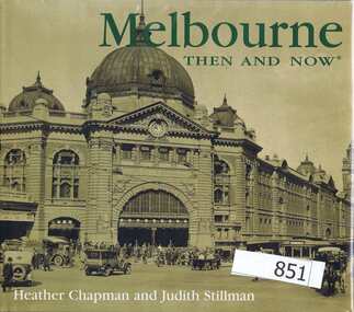
Book, Thunder Bay Press, Melbourne: then and now; by Heather Chapman and Judith Stillman, 2005_
This book shows early photographs of Melbourne landmarks and compares them with the same site in the 21st century. Some building remain and some sites have been redeveloped.A comparison of sites within Melbourne.144 pages, colour and black and white illustrations. Hard cover.melbourne, historic buildings -
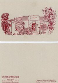 Ringwood and District Historical Society
Card - Commemorative Stationery, Printeam, Ringwood Primary School 2997: cards and etching of 1921 school. 1989, 1989
Card printed for the centenary celebration of Ringwood Primary School 1889-1989. Original site in 1898 Ringwood Street. The school moved to Greenwood Avenue site in 1921.Four buff coloured cards and envelopes with etching in red ink of 1921 Ringwood School no. 2997.Graphic by Nerrelle Williamson -
 Old Colonists' Association of Ballarat Inc.
Photographs, Clare Gervasoni, Renovation of Shops Associated with the Ballarat Old Colonist Hall, 2017, 04/08/2017
The Ballarat Old Colonists' Hall is on the site of the former Government Camp which governed the goldfield. The bluestone used in the foundation of the hall was reused from a building demolished on the site. A number of colour photographs showing the interiors of the Old Colonists' shops in Lydiard Street before the replacement of floorboards. ballarat old colonists' club, old colonists' association ballarat, old colonists' hall, bluestone, government camp, lydiard street north, shops -
 Federation University Historical Collection
Book - Scrap Book, Ballarat School of Mines Scrap Book, 1965-1967, 1965-1967
The Ballarat School of Mines was established in 1870.Grey hard covered scrapboks with clippings relating to the Ballarat School of Mines, including: 24-5-1965 - Mildura Students at School of Mines 16-9-1965 - Ballarat Junior Technical School Mothers' Club Clock 23-11-1965 - Plan for Mall in Lydiard Street 29-03-1966 - Punch card equipment for School of Mines 10-05-1966 - Apprentice Craftsmen Certificates 25-7-1966 - Ian Barker 01-08-1966 - Woman Diplomate - Jennifer Drummond and Sue Milbourne 05 August 1967 - New Woolclassing and Motor Mechanics Building on the corner of Albert Street and Grant Street 09-09-1966 - New School site 23-09-1966 - Inspection of gaol site 22-09-1966 - Murray Gillin 19-10-1966 - Michael Young 26-01-1967 - A new site for SMB (Mt Helen Campus) 06-05-1967 - Geology Gift to SMB (William Baragwanath)ballarat school of mines, murray gillin, gerald jenzen, ludovio hart, photography, mount helen campus, ron quick, lydiard street closure, ballarat junior technical school student accomodation, r.r. watson, phillip law, martin report, punch card equipment, ken ogden, ian barker, jennifer drummond, sue milbourne, women and physics, greg mcrae, jan butterworth, former ballarat gaol, peter donaldson, michae young, mount clear site, j.r. pound, eric sharman, chris sanos, john gorton, zaiga baltrocis, motor mechanics & woolclassing building, women, women diplomates, jennifer drummong, technical education growrh, e.j. barker, mothers club, w. johnson, pottery, ceramics, ian billington, matriculation, victoria institute of colleges, punch cards, computer, craftsman certificates, new campus site, architecture, michael young, sebastopol technical school, ballarat school of mines master plan, fourth university, 4th university, r. giles, william baragwanath geology collection, phil day, john phillips, greg strang, plumbing, centenary, langi logan minefield, a.l. mckenzie, peter bennett, r.w. richards medal, woolclassing, motor mechanics, new building, albert street, grant street, pound -
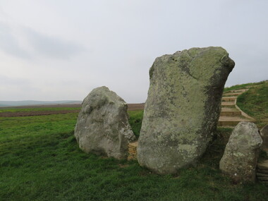
 Ballarat Heritage Services
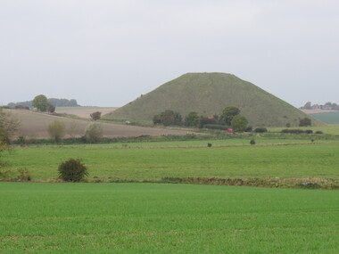
Photograph - Colour, Avebury World Heritage Site, Prehistoric Monuments, England, 2016
Colour photograph of the Silbury Hill, an immense Neolithic man-made mound part of the Avebury World Heritage Site. The Avebury World Heritage Site is a complex of outstanding prehistoric monuments comprising Windmill Hill (Early Neolithic enclosure and Bronze Age burial mounds); Silbury Hill; West Kennet Long Barrow; Avebury Stone Circles and West Kennet Avenue; The Sanctuary (site of stone and timber circles). It is part of National Trust and English Heritage. Visitors may walk to sites.avebury world heritage site, mound, prehistoric monuments, silbury hill, west kennet long barrow, neolithic, world heritage -
 Ballarat Heritage Services
Photograph - Colour, Avebury World Heritage Site, Prehistoric Monuments, England, 2016
Colour photograph of the Silbury Hill, an immense Neolithic man-made mound part of the Avebury World Heritage Site. The Avebury World Heritage Site is a complex of outstanding prehistoric monuments comprising Windmill Hill (Early Neolithic enclosure and Bronze Age burial mounds); Silbury Hill; West Kennet Long Barrow; Avebury Stone Circles and West Kennet Avenue; The Sanctuary (site of stone and timber circles). It is part of National Trust and English Heritage. Visitors may walk to sites.Colour photograph of Avebury World Heritage Stte.avebury world heritage site, prehistoric monuments, rocks -
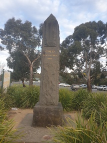 Federation University Historical Collection
Photograph, Clare Gervasoni, Ballarat Gold Discovery Obelisk, 06/09/2022
The obelisk is not on the original site. Coloured photograph of a basalt obelisk to mark the discovery of gold at Ballarat.ballarat gold discovery obelisk -
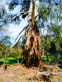 Eltham District Historical Society Inc
Photograph, Large Manna Gum Scar Tree, Wingrove Park, Eltham
A significant site for the WurundjeriColour photographscar tree, wurundjeri, wingrove park -
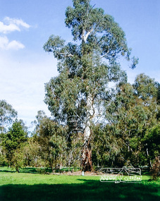 Eltham District Historical Society Inc
Photograph, Large Manna Gum Scar Tree, Wingrove Park, Eltham
A significant site for the WurundjeriColour photographscar tree, wurundjeri, wingrove park