Showing 10703 items matching "east melbourne"
-
 Ringwood and District Historical Society
Photograph, Loughnan Road 1960
Catalogue card reads, "Loughnan Road 1960. Looking at Ringwood. Round house being built, looking slightly east". -
 Ringwood and District Historical Society
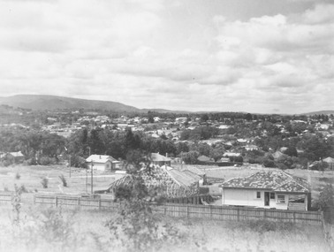
Photograph, View from Loughnan's Hill looking south east - c.1946
View from Loughnan's Hill looking south east - 1946. Written on back of photograph, "Smoke on left from Bamford's Timber Yard". -
 Ringwood and District Historical Society
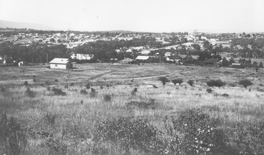
Photograph, View from Loughnan Rd. looking south east over Harrison Street/Andrew Street corner, c.1949
Black and white photograph showing some vacant land and new houses under construction. Developed area in background. (3 copies)Typed below photograph, "View from Loughnan Rd. looking south east, 1949". Written on backing sheet, "View from Loughnan Rd. to corner Harrison and Andrew Street, c1949". -
 Ringwood and District Historical Society
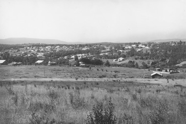
Photograph, Looking east from Loughnan Road across William & Andrew Streets c.1946
... Road Ringwood North melbourne Looking east from Loughnan Road ...Looking east from Loughnan Road across William & Andrew Streets 1946 -
 Ringwood and District Historical Society
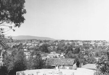
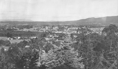
Photograph, Ringwood from Loughnans Hill. 1948
Black and white photograph taken from hill looking across valley towards settled area. Mountains in background. Catalogue card reads, "View from Loughnans Hill looking south east" -
 Ringwood and District Historical Society
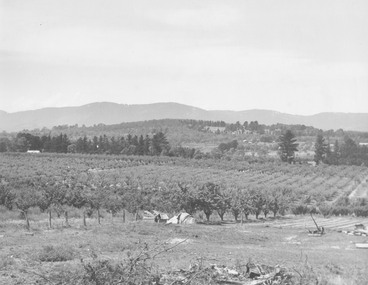
Photograph, View from Wonga Rd. over Mullum Rd. (centre) and beyond - 1946. Orchards: French, Vergers
"View from Wonga Rd. looking east towards Mullum Rd. 1946" and "Looking from Wonga Rd. over Mullum Rd. (centre) and beyond. Orchards: French, Vergers". -
 Ringwood and District Historical Society
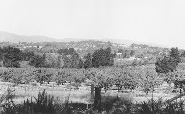
Photograph, Mr. F. Goulding's orchard. Looking across to Ringwood East from Wonga Rd. 1960
Typed below photograph, "Mr. F. Goulding's orchard. Looking across to Ringwood East from Wonga Rd. 1960". -
 Ringwood and District Historical Society
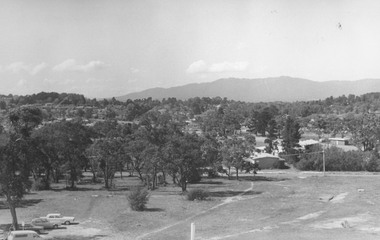
Photograph, Series of photographs taken from roof of Civic Centre in Braeside Avenue Ringwood East, 1973. (14 images)
Written on backing sheet, "Looking from roof of Civic Centre across sports grounds, Ringwood East, 1973". -
 Ringwood and District Historical Society
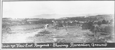
Photograph, Birds eye view East Ringwood - Showing Recreation Ground. Mt. Dandenong Rd. on right. Taken from present Civic Centre site. Football final in progress - 1923
Written below photograph, "Birds eye view East Ringwood - Showing Recreation Ground". Typed below photograph, "Mt. Dandenong Rd. on right. Taken from present Civic Centre site. Football final in progress - 1923". -
 Ringwood and District Historical Society
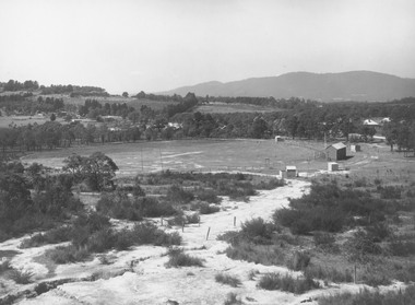
Photograph, East Ringwood oval c.1928
Typed below photograph, "View of East Ringwood oval from present site of Civic Centre. Mt. Dandenong Rd. on right - 1935". Catalogue card reads, "Suggest this photo is taken early 1920s.... E.R.F.C. was established approx. 1928. Prior to this the Ringwood F.C. played on the oval". -
 Ringwood and District Historical Society
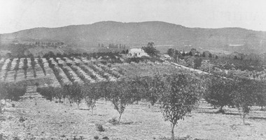
Photograph, View from Canterbury Road/Balfour Avenue area overlooking Martell's orchard, Heathmont, 1929
Black and white photograph of orchard. House in middle range, mountains in background. Photograph appears to be reproduced from subdivisional brochure. Note inserted in sleeve reads, "It has been pointed out that the mountains are to the east and the view is looking south. This therefore is not a 'straight' photograph. House still exists in Eden Avenue at October, 1996".(3 copies).Typed below photograph, "Panoramic view taken on the estate". "View overlooking Martell's orchard, Heathmont, 1929". Taken from corner Canterbury Rd. and Balfour Ave. looking south. Dandenong Creek just beyond house. Washusen Rd. on right". Written on back of one of the copies, "Heathmont Station Estate 1922". "Station Street, Lisgoold St. Canterbury Rd. Vivienne Cres. Balfour Ave." -
 Ringwood and District Historical Society
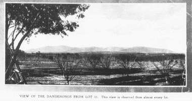
Photograph, Mullers orchard, Heathmont. Looking east from cnr. Canterbury and Dickasons Rds. "Charm View Estate" - 1926
Printed below photograph, "View of the Dandenongs from Lot 11. This view is observed from almost every lot". Written on back of a photograph, "Photo taken from sub. div. plan land sales. Charm View Estate, Heathmont, 1926?" Another copy reads, "Mullers orchard, Heathmont. Taken from cnr. Canterbury and Dickasons Rds. Looking east - 1926". -
 Ringwood and District Historical Society
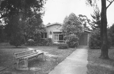
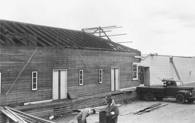
Photograph, Health Centre, Ringwood East, 1973
Written on backing sheet, "Health Centre, Ringwood East, 1973" -
 Ringwood and District Historical Society
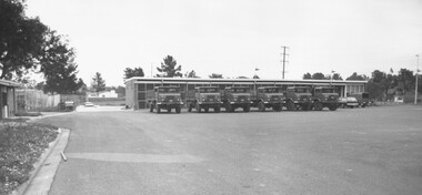
Photograph, Army Depot, Dublin Road, Ringwood East, 1973
Written on backing sheet, "Army Depot, Dublin Road, Ringwood East, 1973". -
 Ringwood and District Historical Society
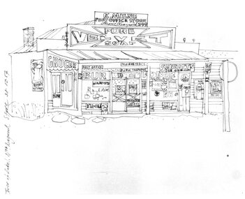
Photograph, Hand drawn picture by Eric Thake dated 1954 depicting Milne's Post Office and Store on the south-east corner of Oban Road and Warrandyte Road, North Ringwood
Typed below picture, "Mr. K. Milnes store. Corner Oban Rd. and Warrandyte Rd. 1954. Now demolished". -
 Ringwood and District Historical Society
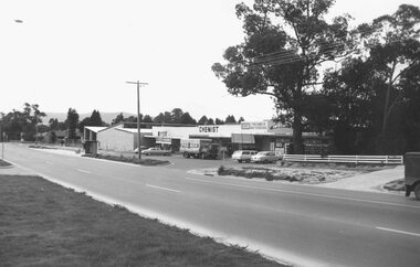
Photograph, Canterbury Road, Heathmont looking east from railway bridge. 1973
Catalogue card reads, "Canterbury Road, Heathmont looking east from railway bridge." -
 Ringwood and District Historical Society
Photograph, Canterbury Road shops, corner Armstrong Road, Heathmont, looking east - 1973
Catalogue card reads, "Canterbury Road shops, corner Armstrong Road, Heathmont, looking east - 1973". -
 Ringwood and District Historical Society
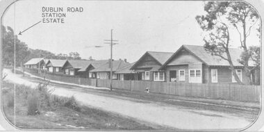
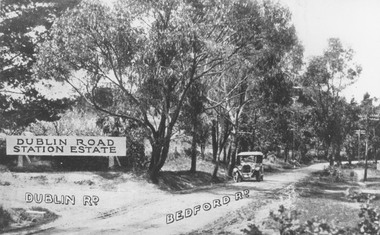
Photograph, Two images of 1924 Dublin Road Station Estate land sale promotional photograph - War of 1914-18 Soldiers homes on Bedford Road
Typed below photograph, "10 modern villas recently erected alongside the estate". Typed below photograph, "Soldiers Homes, Bedford Road. 1924." Catalogue card reads, "Soldiers homes Bedford Road, looking east from outside shops corner Illoura Ave. War of 1914-18 Soldiers Homes. From land sale brochure." -
 Ringwood and District Historical Society
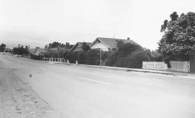
Photograph, Soldiers Homes' Bedford Rd. looking east from outside shops, Illoura Ave. 1973"
Typed below photograph, "Bedford Rd. looking uphill from near corner of Illoura Ave. 1974" Date of 1973 written on backing sheet. Catalogue card reads, "'Soldiers Homes' Bedford Rd. looking east from outside shops, Illoura Ave. 1973". -
 Ringwood and District Historical Society
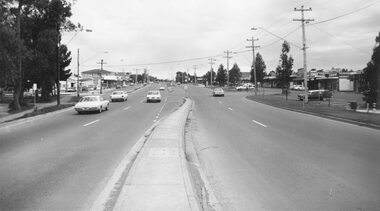
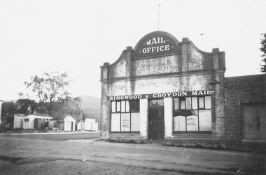
Photograph, Adelaide Street, Ringwood, showing 'Mail' Office - looking east. Demolished for Eastland parking area. Photograph circa early 1960s
Catalogue card reads, "Adelaide St. showing 'Mail' Office - looking east. Demolished for Eastland parking area". -
 Ringwood and District Historical Society
Photograph, Club Hotel, Ringwood from Whitehorse Road. Mt. Dandenong Road to old East Ringwood looking south. Taken about 1900-10
Catalogue card reads, "Club Hotel, Ringwood from Whitehorse Road. Mt. Dandenong Road to old East Ringwood looking south. Taken about 1900-10". Label below photograph is dated 1904. -
 Ringwood and District Historical Society
Photograph, View north east from Charter Street of new market buildings - 15/1/1982
Written on back of photograph, "E652. N17A. 15/1/82. View north east from Charter Street of new market buildings." -
 Ringwood and District Historical Society
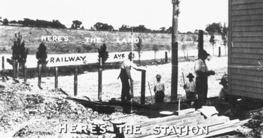
Photograph, Two promotional photographs depicting Ringwood East Railway Station Estate c.1925
Written on back of one of the photos, "Ringwood East Railway Station entrance and ext ramp opens right on the this Estate" and "Ringwood East Railway Station Estate" -
 Ringwood and District Historical Society
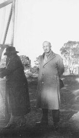
Photograph, A.T. Miles - opening of Tennis Court at East Ringwood whilst mayor of Ringwood, 1937. Two photographs
Written on back of photograph, "Opening of Tennis Court at East Ringwood whilst mayor of Ringwood, 1937". -
 Ringwood and District Historical Society
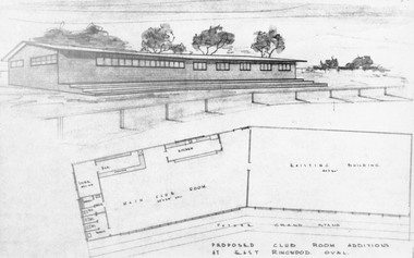
Photograph, Architectural drawings for proposed club room additions at Ringwood East oval -1965. (Photograph)
Catalogue card reads, "Ringwood East Football Pavilion". -
 Ringwood and District Historical Society
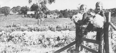
Photograph, Hazel Howship and Merle Purser with chrysanthemums at Lutch Floral Farm, East Ringwood,1939
Black and white photographAccompanying sheet of paper reads- "Chrysanthemums. Inspecting chrysanthemums while sitting on the gate of the Floral Farm of Mr. S. R. Lutch at East Ringwood on 24th April 1939. Hazel Howship and Merle Purser, daughter of Cr. Purser." "This photo appeared in the 'Herald' on Saturday Nov. 8th, 1958."agriculture -
 Ringwood and District Historical Society
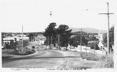
Postcard, Maroondah Highway West, Ringwood, 1956. Entrance to the town of Ringwood, Vic., looking East - Rose Series Postcard P13868
Black and white postcard photograph of Maroondah Highway Ringwood looking east. Note VC Item 4763 is a postal cover imprinted with Windmill Joinery. Inscription on front: "Rose Series P13688 Entrance to the Town of Ringwood, Vic" Hand Written on back of card, "1956 - 'Windmill' joinery on right - Coach and Horses Hotel on left". -
 Ringwood and District Historical Society
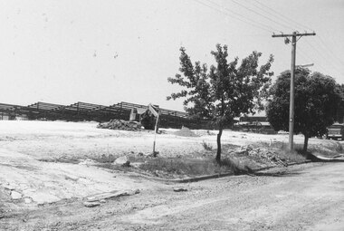
Photograph, Ringwood Cool Store demolition, Maroondah Highway, Ringwood - 1963
Black and white photographWritten on back of photograph: "Cool Store demolition, 1963". Photograph taken by Brian Pump, 36 Knaith Rd, Ringwood East, 3135. -
 Ringwood and District Historical Society
Photograph, Corner Dublin and Bedford Rds. Ringwood East, 10/11/19. Bloods Estate Sale
Typed below photograph, "Corner Dublin and Bedford Rds., 10/11/19". Written on back of photograph, "Bloods Estate Sale". -
 Ringwood and District Historical Society
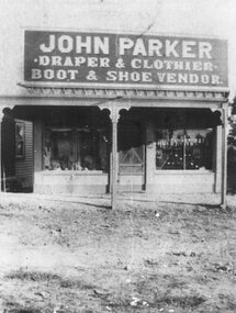
Photograph, Maroondah Highway Central, Ringwood. John Parker's Store, Whitehorse Rd- 1908
Black and white photograph (2 copies)Typed on front of backing sheet: "John Parker's Store, Whitehorse Rd. 1908". Written on back of photograph: "Main St slightly east of Adelaide St- c1908. Demolished for Eastland. Sign above veranda reads, "John Parker, Draper & Clothing. Boot & Shoe Vendor."