Showing 4552 items matching "historical map"
-
 Port Melbourne Historical & Preservation Society
Photograph - Launch of History of a Street Precinct, 25 Sep
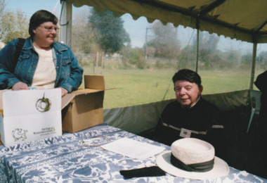
In 2005, members of the PMH&PS undertook a study of the residents of the houses in a Port Melbourne street precinct from the 1880s to 1960. The area is bounded by Evans Street, the E side of Bridge Street, S side of Williamstown Road, Farrell Street both the E & W sides plus the section of Ross Street between Farrell and Bridge and the part of Derham Street between Farrell and Bridge. The resulting map and an interactive CD won the Best Community Research, Registers & Records project at the 2007 Victorian Community History Awards. The project was launched on the railway reserve near the corner of Evans & Farrell streets. L- R - Val POWER, Jim POWER.Two members of the PMHPS the launch of the History of a Street Precinct25/9/05 Val Power, Jim Powerhistory of a street precinct, val power, jim power -
 Port Melbourne Historical & Preservation Society
Photograph - Launch of History of a Street Precinct, 25 Sep
In 2005, members of the PMH&PS undertook a study of the residents of the houses in a Port Melbourne street precinct from the 1880s to 1960. The area is bounded by Evans Street, the E side of Bridge Street, S side of Williamstown Road, Farrell Street both the E & W sides plus the section of Ross Street between Farrell and Bridge and the part of Derham Street between Farrell and Bridge. The resulting map and an interactive CD won the Best Community Research, Registers & Records project at the 2007 Victorian Community History Awards. The project was launched on the railway reserve near the corner of Evans & Farrell streets. L- R - Robyn ?, Maralyn KOBELTMaralyn & Robin at the launch of the History of a Street Precinct25/9/05 Robyn ?, Maralyn Kobelthistory of a street precinct, maralyn kobelt -
 Port Melbourne Historical & Preservation Society
Photograph - Launch of History of a Street Precinct, 25 Sep
In 2005, members of the PMH&PS undertook a study of the residents of the houses in a Port Melbourne street precinct from the 1880s to 1960. The area is bounded by Evans Street, the E side of Bridge Street, S side of Williamstown Road, Farrell Street both the E & W sides plus the section of Ross Street between Farrell and Bridge and the part of Derham Street between Farrell and Bridge. The resulting map and an interactive CD won the Best Community Research, Registers & Records project at the 2007 Victorian Community History Awards. The project was launched on the railway reserve near the corner of Evans & Farrell streets. Darren Ray, Mayor of City of Port Phillip.City of Port Phillip mayor, Cr Darren Ray at the launch of the History of a Street Precinct25/9/05 Darren Ray Mayor CoPPhistory of a street precinct, darren ray -
 Port Melbourne Historical & Preservation Society
Photograph - Launch of History of a Street Precinct, 25 Sep
In 2005, members of the PMH&PS undertook a study of the residents of the houses in a Port Melbourne street precinct from the 1880s to 1960. The area is bounded by Evans Street, the E side of Bridge Street, S side of Williamstown Road, Farrell Street both the E & W sides plus the section of Ross Street between Farrell and Bridge and the part of Derham Street between Farrell and Bridge. The resulting map and an interactive CD won the Best Community Research, Registers & Records project at the 2007 Victorian Community History Awards. The project was launched on the railway reserve near the corner of Evans & Farrell streets. Janet BOLITHO, former mayor of City of Port Phillip.Former City of Port Phillip mayor, Janet Bolitho, at the launch of the History of a Street Precinct25/9/05 Janet Bolithohistory of a street precinct, janet bolitho -
 Port Melbourne Historical & Preservation Society
Photograph - Launch of History of a Street Precinct, 25 Sep
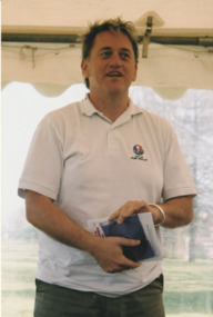
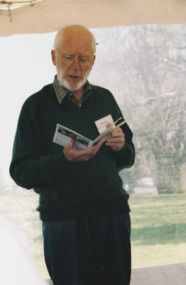
In 2005, members of the PMH&PS undertook a study of the residents of the houses in a Port Melbourne street precinct from the 1880s to 1960. The area is bounded by Evans Street, the E side of Bridge Street, S side of Williamstown Road, Farrell Street both the E & W sides plus the section of Ross Street between Farrell and Bridge and the part of Derham Street between Farrell and Bridge. The resulting map and an interactive CD won the Best Community Research, Registers & Records project at the 2007 Victorian Community History Awards. The project was launched on the railway reserve near the corner of Evans & Farrell streets. Co-author Graham BRIDE.Co-author, Graham Bride, at the launch of the History of a Street Precinct25/9/05 Graham Bridehistory of a street precinct, graham bride -
 Port Melbourne Historical & Preservation Society
Photograph - Launch of History of a Street Precinct, 25 Sep
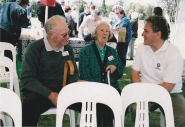
In 2005, members of the PMH&PS undertook a study of the residents of the houses in a Port Melbourne street precinct from the 1880s to 1960. The area is bounded by Evans Street, the E side of Bridge Street, S side of Williamstown Road, Farrell Street both the E & W sides plus the section of Ross Street between Farrell and Bridge and the part of Derham Street between Farrell and Bridge. The resulting map and an interactive CD won the Best Community Research, Registers & Records project at the 2007 Victorian Community History Awards. The project was launched on the railway reserve near the corner of Evans & Farrell streets. L - R - Unknown, Norah HOWARD, Mayor Darren RAY.CoPP mayor and PMHPS members at the launch of the History of a Street Precinct25/9/05 Not known, Norah Howard, Darren Ray, Mayorhistory of a street precinct, darren ray, norma howard -
 Port Melbourne Historical & Preservation Society
Photograph - Launch of History of a Street Precinct, 25 Sep
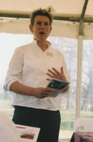
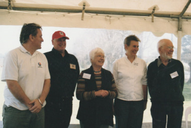
In 2005, members of the PMH&PS undertook a study of the residents of the houses in a Port Melbourne street precinct from the 1880s to 1960. The area is bounded by Evans Street, the E side of Bridge Street, S side of Williamstown Road, Farrell Street both the E & W sides plus the section of Ross Street between Farrell and Bridge and the part of Derham Street between Farrell and Bridge. The resulting map and an interactive CD won the Best Community Research, Registers & Records project at the 2007 Victorian Community History Awards. The project was launched on the railway reserve near the corner of Evans & Farrell streets. l - R - Mayor Darren RAY, David THOMPSON, Margaret BRIDE, Janet BOLITHO, Graham BRIDE.CoPP mayor and PMHPS members involved in the production at the launch of the History of a Street Precinct25/9/05 Mayor, David Thompson, Margaret Bride, Janet Bolitho, Graham Bridehistory of a street precinct, darren ray, graham bride, margaret bride, janet bolitho, david thompson -
 Port Melbourne Historical & Preservation Society
Photograph - Launch of History of a Street Precinct, 25 Sep
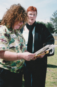
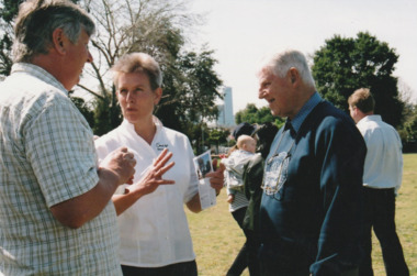
In 2005, members of the PMH&PS undertook a study of the residents of the houses in a Port Melbourne street precinct from the 1880s to 1960. The area is bounded by Evans Street, the E side of Bridge Street, S side of Williamstown Road, Farrell Street both the E & W sides plus the section of Ross Street between Farrell and Bridge and the part of Derham Street between Farrell and Bridge. The resulting map and an interactive CD won the Best Community Research, Registers & Records project at the 2007 Victorian Community History Awards. The project was launched on the railway reserve near the corner of Evans & Farrell streets. L - R - Unknown, Janet BOLITHO, Glen STUART.CoPP mayor and PMHPS members at the launch of the History of a Street Precinct25/9/05 Not known, Janet Bolitho, Glen Stuarthistory of a street precinct, janet bolitho, glen stuart -
 Port Melbourne Historical & Preservation Society
Map - Melbourne and suburbs, Department of Lands and Survey, 1 May 1934
Large printed map of Melbourne and suburbs 1936 showing historic sightsmelbourne, south melbourne, transport - tramways, transport - railways -
Port Melbourne Historical & Preservation Society
Plan - Proposed Lorimer Street realignment, City of Port Melbourne, 28 Oct 1938
Printed map of City of Port Melbourne with proposed Lorimer Street realignment marked in red and blue.Pencilled lower right: Proposed realignment Lorimer St Also 'Request by Council under Sec 523 L. Getch' : (Getel?)engineering - roads streets lanes and footpaths, l getel, l getch -
Port Melbourne Historical & Preservation Society
Map - City of Port Melbourne, Department of Lands and Survey, 29 Nov 1938
Printed map of City of Port Melbourne - Fishermens Bend area and down to Williamstown Road (Kitchens etc). 1938Red pencil marks through existing Lorimer St (refer 306)built environment - industrial, health - general health, fishermans bend, j kitchen & sons pty ltd -
Port Melbourne Historical & Preservation Society
Plan - Melbourne and suburbs sewerage works, MMBW, 1 Jul 1908
MMBW map of Melbourne and Suburbs sewerage work to 1-7-1908. Reticulation areas in red, reticulation areas under construction in blue.engineering - canals and drainage, engineering - board of works -
Port Melbourne Historical & Preservation Society
Map - Footscray, Public Lands Office, 19 Oct 1857
Map of Footscray, west of Saltwater Creek; south of Hopkins Street, east of Railway and north southern boundary of Botanical Garden reserve.The Township of Footscray, Parish of Cut-Paw-Pawfootscray -
Port Melbourne Historical & Preservation Society
Plan - Map and aerial photo of Port Melbourne, c. 1990
Notations made as a result of conversations Anne had in the early 1990s with an elderly male resident of Port Melbourne.Map and Aerial photo of Port Melbourne with handwritten annotations detailing the location of various buildings, trotting tracks, etc which previously existed in Port Melbourne (recollections only).fishermans bend -
Port Melbourne Historical & Preservation Society
Photograph - Aerial view of Port Melbourne, c. 1990
Notations made as a result of conversations Anne had in the early 1990's with an elderly male resident of Port Melbourne.Map and aerial photo of Port Melbourne with handwritten annotations detailing the location of various buildings, trotting tracks, etc which previously existed in Port Melbourne (recollections only).fishermans bend -
Port Melbourne Historical & Preservation Society
Map - Chart, Hobson's Bay, river and navigational aids, 1839 - 1843
On back is handwritten note - Hobson's Bay pp from HMS Beagle 1838-43.Map (Chart) of Hobson's Bay, River and Navigational Aids 1839. (Latrobe Library). in photographic form.melbourne harbor trust - port of melbourne authority, hobson's bay -
Port Melbourne Historical & Preservation Society
Map - Chart, Port Phillip, 1930
Photocopy in two large sections, of soundings chart for Port Phillip Bay, surveyed by Commander Henry L Cox RN, 1864, with corrections and additions to 1921. Top section (two copies)(Original had stamp of John Donne & Son Stationers)transport - shipping, hobson's bay, port phillip bay -
Port Melbourne Historical & Preservation Society
Map - Chart, Port Phillip, 1930
Photocopy in two large sections, of soundings chart for Port Phillip Bay, surveyed by Commander Henry L Cox RN, 1864, with corrections and additions to 1921. Lower section.(Original had stamp of John Donne & Son Stationers)transport - shipping, port phillip bay -
Port Melbourne Historical & Preservation Society
Map, City of Port Melbourne, Oct 1963
Gives a visual understanding of the Port Melbourne area in 1963A detailed map of the Port Melbourne area in October 1963. Details roads and laneways, undeground cables, light and power poles, sewer, bridges, piers reserve and park areas.local government, built environment, piers and wharves, natural environment - beaches and foreshore, parks and gardens, piers and wharves - princes pier, piers and wharves - station pier, engineering - roads streets lanes and footpaths, engineering - canals and drainage -
Port Melbourne Historical & Preservation Society
Map - Proposed cut and Ferguson Dock, Port Melbourne, Jul 2008
Map of proposed cut and Ferguson Dock which would have run from near the location of Princes Pier to swinging basin in Yarra River. Varied information on back - weather and some local informationpiers and wharves - miscellaneous, melbourne harbor trust - port of melbourne authority, mr ferguson, fishermans bend, ferguson dock -
Port Melbourne Historical & Preservation Society
Article - Newspaper cutting, Analysis of proposed dock and cutting, Jul 2008
Newspaper cutting with proposal for dock and cutting by Mr Ferguson. Analysis of the scheme and mappiers and wharves - miscellaneous, melbourne harbor trust - port of melbourne authority, mr ferguson, fishermans bend, ferguson dock -
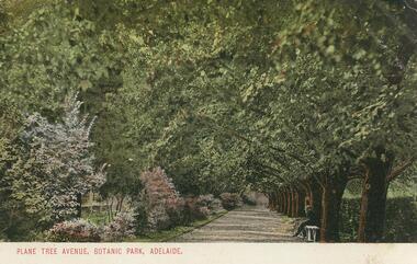 Bendigo Historical Society Inc.
Postcard - GLADYS DEAN COLLECTION: POSTCARD, 1906 - 1908
Coloured photographic postcard with 1cm white border at bottom edge. Image depicts an avenue of plane trees opposite a flower border. A person is seated on a white bench on the right hand side of the avenue. The words Plane Tree Avenue, Botanic Park, Adelaide are printed in red in the border. On the reverse, the words South Australia Post Card are printed with a map of Australia at the top. Card is addressed to Miss R Dean Golden Square Victoria and a one penny stamp is affixed.South Australia Post Cardpostcard -
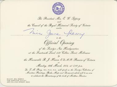 Bendigo Historical Society Inc.
Document - INVITATION, 1974
Official invitation to Miss June Parry to official opening of the new headquarters for the Royal Historical Society. Large cream coloured card the the emblem of the Royal Historical Society printed in blue at the top. The following words are printed in black script: The President Mrs E W Tipping and the Council of the Royal Historical Society of Victoria invites Miss June Parry to the Official Opening of the Society's New Headquarters at the Fourteenth level 459 Collins Street Melbourne by the Honourable R J Hamer Premier of Victoria on Monday 18th March 1974 at 5:00pm. Dr T M Perry will speak on the Societys Collection of Maritime Paintings, Books, Maps and Documents which will be on view to celebrate the Bicentenary of the birth of Matthew Flinders.event, official -
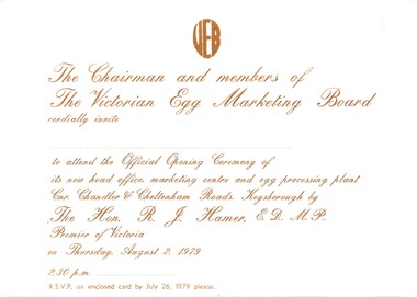 Bendigo Historical Society Inc.
Document - CEPA COLLECTION: VICTORIAN EGG MARKETING BOARD OFFICIAL OPENING
Victorian egg board (VEB) official opening - Thursday 2 August 1979 Three cards a official invitation to opening - white card with brown printing b VEB official Oening response card - yellow card with brown printing c VEB official opening Directional Map - yellow card with brown printing -
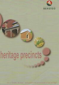 Bendigo Historical Society Inc.
Map - HERITAGE PRECINCTS
Map. Heritage precincts. City of Greater Bendigo - dedicated to the preservation of our heritage.map, bendigo, heritage precincts -
 Bendigo Historical Society Inc.
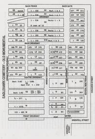
Book - NORM GILLIES COLLECTION: COMPANY PROMOTIONAL POCKET DIARY
Gillies Company promotional gift pocket diary 1985 - blank unused Green plastic cover, with blue text including coloured maps Diary / almanac For 1985, covering 28/12/1984 to 02/01/1986 One of two pocket diaries (1984 diary refer 11850.17) -
 Bendigo Historical Society Inc.
Document - FRIENDS OF WHITE HILLS CEMETERY COLLECTION: BROCHURE, 2014
Brochure. Eaglehawk Monumental Cemetery tour brochure. A tribute to some of the miners from Eaglehawk who lost their lives while on duty. Prepared by Bev Hanson and John Kelly 2014. Map on back of sheet.document, memo, brochure -
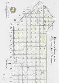 Bendigo Historical Society Inc.
Map - FRIENDS OF WHITE HILLS CEMETERY COLLECTION: TWO MAPS
Maps. Two maps of Bendigo Cemetery. (a) Bendigo Cemetery produced by Bendigo Cemeteries Trust. (b) Bendigo Remembrance Park produced by Remembrance Parks Central Victoria.map, bendigo, bendigo cemetery and remembrance park -
 Bendigo Historical Society Inc.
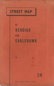
Document - BENDIGO TOURISM BROCHURES COLLECTION: MAP OF BENDIGO AND EAGLEHAWK
Document. Orange covered booklet containing fold-out Street Map of Bendigo and Eaglehawk. Four page index of street names pasted inside back cover. Printed on front cover 2/6, ''Bolton Bros. Printers- Bendigo.document, memo, bendigo tourism brochures -
 Bendigo Historical Society Inc.
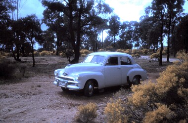
Slide - PETER ELLIS COLLECTION: SLIDE, May 1970 - Jan 1972
Coloured slide transparency. Image is of a car parked in a bush setting off a road. The car is a light coloured FJ Holden and is parked on dirt amongst low scrub and trees in the background. The words The car used to map the Whipstick are handwritten along the top border and the words The Whipstick Car Aug 31st 1974 are handwritten along the bottom border.Kodachrome Transparencyslide, bendigo, bendigo institute of technology