Showing 11172 items matching "planning "
-
 Port Melbourne Historical & Preservation Society
Plan - Open drainage channel, cnr Beach Street and Railway Place, Port Melbourne, Frederick William Bull, Principal Surveyor, 1862
Plan for open drainage channel at corner of Beach Street and Railway Place, 1892."Open Channel at Foot of Railway Place":Signed by Frederick William Bull, Principal Surveyorengineering - canals and drainage, engineering department - borough of sandridge, frederick william bull, business and traders - hotels -
Port Melbourne Historical & Preservation Society
Plan - Central rockery, Graham Street between Station and Princes Street, Port Melbourne, Engineering Department, City of Port Melbourne, 1950s
Plan - Central rockery in Graham Street between Station and Princes Street, 1950s.built environment - civic, parks and gardens -
Port Melbourne Historical & Preservation Society
Plan - Soundings, Yarra River, Operation Division, Port of Melbourne Authority, Jul 1987
Port of Melbourne Authority. Plan: soundings of Yarra River at entrance Beacon No 23melbourne harbor trust - port of melbourne authority, beacon no 23 -
Port Melbourne Historical & Preservation Society
Map - Yarra River, Saltwater River and Coode's Canal, 1935
Plan No.7. Yarra River, Saltwater River, Coode's Canal area 1935.Signed Walker A.W.melbourne, a w walker, melbourne and metropolitan board of works, mmbw -
Port Melbourne Historical & Preservation Society
Plan - Elevations at Concourse Level for gangway at Outer West berth, Station Pier, Port Melbourne, Port of Melbourne Authority, 1987
Plan - Elevations at Concourse Level - Gangway Station Pier - Outer West Berthpiers and wharves - station pier, melbourne harbor trust - port of melbourne authority -
Port Melbourne Historical & Preservation Society
Plan - Details at Concourse Level for gangway at Outer West berth, Station Pier, Port Melbourne, Port of Melbourne Authority, 1987
Plan - Details at Concourse Level - Gangway - Station Pier - Outer West Berthpiers and wharves - station pier, melbourne harbor trust - port of melbourne authority -
Port Melbourne Historical & Preservation Society
Plan - Williamstown Road from Farrell Street to Derham Street, Engineering Department, Town of Port Melbourne, 1893 - 1919
Plan of Williamstown Road, from Farrell Street to Derham Street. Loan No.5.engineering - roads streets lanes and footpaths -
Port Melbourne Historical & Preservation Society
Plan - Various ships, Melbourne Harbor Trust, 1980s
Various shipping plans of passenger ships from Melbourne Harbor Trust 1980s.piers and wharves - station pier, melbourne harbor trust - port of melbourne authority -
Port Melbourne Historical & Preservation Society
Plan - Concept, Boulevard upgrade at Sandridge Beach, landscape, 2003
Plans. Landscape concept for the Boulevard upgrade at Sandridge Beach. Dated October 2003local government - city of port phillip, engineering - roads streets lanes and footpaths -
Port Melbourne Historical & Preservation Society
Plan - Improvments, Beach Street, Port Melbourne, Beach Street Improvements, 9 Nov 1915
Plan for Beach Street improvements 1915 - hand drawn in ink and hand coloured.Signed by Heath and Chairman RH Gill - Scale altered in red ink from 2ft to the inch to 4ft to the inch (at bottom centre)built environment - civic, arthur victor heath, town clerks, richard henry gill, mayors -
Port Melbourne Historical & Preservation Society
Plan - Football Ground, Department of Survey & Lands, 13 May 1880
Plan for Football Ground on land being granted by Department of Survey & Lands, 1880sport - australian rules football, sport - recreational grounds, j kitchen & sons pty ltd, port melbourne football club, pmfc -
 Bendigo Historical Society Inc.
Map - JACK FLYNN COLLECTION: TARNAGULLA SHEET 4, 25/11/1926
Map: Parish of Tarnagulla Sheet 4, Counties of Gladstone and Bendigo. Parish plan.Photo-Lithographed at the Department of lands and Survey, Melbourne by W. J. Butson. 25.11.26map, gladstone, parish plan, tarnagulla sheet 4 -
 Bendigo Historical Society Inc.
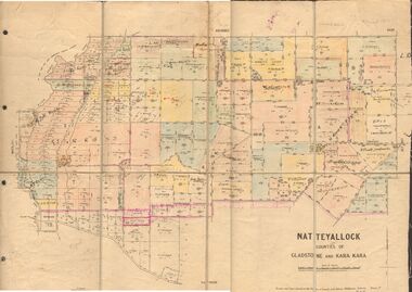
Map - JACK FLYNN COLLECTION: NATTE YALLOCK, 22/06/1937
Map: Parish of Natte Yallock, Counties of Gladstone and Kara Kara. Parish plan.By Authority H.J. Green Government Printer Melbourne. Drawn and Reproduced at the Depart., of Lands and Survey, Melbourne, Victoria.map, gladstone, parish plan, natte yallock -
 Bendigo Historical Society Inc.
Map - JACK FLYNN COLLECTION: LAANACOORIE, No date visible
Map: Parish of Laanacoorie, County of Bendigo. Parish plan. Half of the sheet is missing.By Authority H.J. Green. Govt, Printer.map, bendigo, parish plan, laanacoorie -
 Bendigo Historical Society Inc.
Map - JACK FLYNN COLLECTION: VILLAGE OF BETLEY, 30/06/1874
Map: Village of Betley, on the Bet Bet Creek, Parish of Dunolly. Parish plan.Photo Lithographed at the Department of Lands and Survey Melbourne by J. Noone 30.6.74map, gladstone, village, betley, bet bet creek, dunolly -
 Bendigo Historical Society Inc.
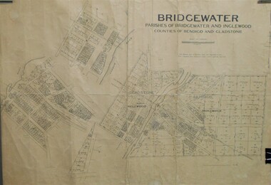
Map - JACK FLYNN COLLECTION: BRIDGEWATER, 10/09/1931
Map: Bridgewater, Parishes of Bridgewater and Inglewood, Counties of Bendigo and Gladstone. Parish plan.map, bendigo, parish plan, bridgewater inglewood -
Bendigo Historical Society Inc.
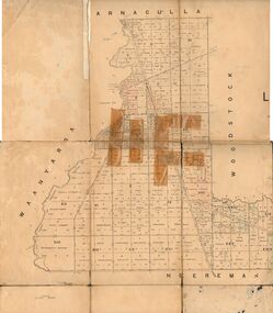
Map - NERRING SHEET 3, 1/12/1894
Map:Neriing sheet 3. parish plan ( number 188 in Map Cupboard 1)map, bendigo, parish plan, nerring -
Bendigo Historical Society Inc.
Map - HUNTLY RESURVEY, 1873
Map: Huntly resurvey. Parish plan ( number 242 in Map Cupboard 1)map, bendigo, parish plan, huntly -
Bendigo Historical Society Inc.
Map - MUSKERRY, No date visible
Map: Parish of Muskerry. Parish plan (number 310 in map cupboard 1)map, parish plan, muskerry -
National Vietnam Veterans Museum (NVVM)
Memorabilia, Memorabilia of Chris Cannin
Copies of photos of the NVVM being constructed & floor plans printed on sheets of paper.national vietnam veterans museum - construction -
 St Kilda Historical Society
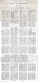
Document, Plan of Town of Melbourne 1837 AD, 1837 (original)
Shows the outcome of the first land sales held in Melbourne, on 1 June and 1 November 1837. All the names and prices for each lot are displayed.Photocopy of "Plan of Town of Melbourne 1837 A.D." showing first land sales.All lots printed with name of buyer and price paid.melbourne - history, town of melbourne- 1837, 19th century -
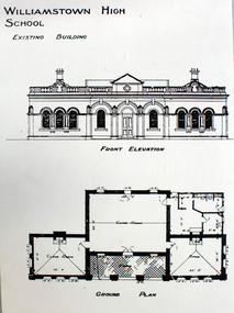 Williamstown High School
Original building 1890s?
Copy of plan and drawing of original building, mounted on board. Accompanied by a laminated caption.Caption reads: Original 1867 building - Williamstowm=n Grammar School Circa 1904.williamstown high school, 1890, school buildings -
University of Melbourne, Burnley Campus Archives
Document - Photocopy, [History of land reservations for Burnley site], 1837-1919
Photocopies of correspondence, newspaper articles, Government Gazette entries and plans - 29 sheetsland reservations, burnley, victoria horticultural society -
University of Melbourne, Burnley Campus Archives
Article - Photocopy, Gardens of the Horticultural Society, 1867
Newpaper article about progress of the gardens, plus Yarra Planning Scheme mapgardens -
University of Melbourne, Burnley Campus Archives
Document, Reconstruction of Gardens new building, 1948-1950
Diary notes by T.H. Kneen, notes of Burnley Gardens Co-ordinated Planningthomas h. kneen, burnley gardens -
Clunes Museum
Map, F.W. NIVEN EMBOSSER
SCROLL - SURVEVOR MAP AND PLAN OF NEW CRESWICK GOLD FIELDS SURFACE LEVELSlocal history, document, maps, mining - maps -
Koorie Heritage Trust
Book, Osborn, Betty et al, Maryborough, a social history, 1854-1904, 1985
The authors have given a picture of Maryborough from the earliest rough life on the diggings when a full-scale rebellion was narrowly averted over an incident at Tipperary Hill, to life at the turn of the century when a more sophisticated society had developed. Maryborough-History-1854-1904. Aborigines, Australian-Maryborough-Jajowurrong. (Dja Dja Wurrung); Aborigines-poisoningxx, 420 p. : ill., facsims., maps, plans, ports. ; 24 cm.The authors have given a picture of Maryborough from the earliest rough life on the diggings when a full-scale rebellion was narrowly averted over an incident at Tipperary Hill, to life at the turn of the century when a more sophisticated society had developed. Maryborough-History-1854-1904. Aborigines, Australian-Maryborough-Jajowurrong. (Dja Dja Wurrung); Aborigines-poisoningmaryborough (vic.) -- history. -
Koorie Heritage Trust
Book, Brooke, Brian (Brian J.) et al, A story of Horsham : a municipal century, 1982
Copy signed by both authors.278 p. : ill., facsims., plan, ports. ; 21 x 29 cm. Copy signed by both authors.1. horsham (vic.) -- history. i. finch, alan, 1934-, 2. aboriginal inhabitants. p.2-4, 3."mulga fred" -
Whitehorse Historical Society Inc.
Pamphlet, Nunawading parks and recreation information, c1982
History, plans and leaflet concerning the Nunawading Horticultural Centre and the Community Gardens Cooperative.History, plans and leaflet concerning the Nunawading Horticultural Centre and the Community Gardens Cooperative.History, plans and leaflet concerning the Nunawading Horticultural Centre and the Community Gardens Cooperative.city of nunawading, horticultural centre, forest hill, nunawading community gardens -
Whitehorse Historical Society Inc.
Document, Division of Survey and Mapping, 1984
Information guide to Parish and Township Plans - Division of Survey and Mapping - Victorian Government..Information guide to Parish and Township Plans - Division of Survey and Mapping - Victorian Government..Information guide to Parish and Township Plans - Division of Survey and Mapping - Victorian Government..crown lands, victorian government, land surveys