Showing 28487 items
matching street street
-
 Melbourne Tram Museum
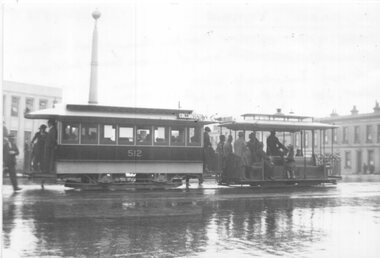
Photograph - Black and White photograph, Ian Hammond, 21/11/1938 12:00:00 AM
... St about to cross over Victoria Street into Lygon Street... to cross over Victoria Street into Lygon Street. Has the 8 hour ...Black and white photograph of a cable tram set in Russell St about to cross over Victoria Street into Lygon Street. Has the 8 hour monument in the background and part of the Emily McPherson School of Domestic Science. Trailer car No. 512 and taken on a wet day. Trailer has the destination of Collingwood. Photo has a detail description on the rear and details of the date and photographer - Ian Hammond, 21-11-1938. Also in an envelope was a hand written note dated 30/10/1995, by Keith about the photo. Filed with photo.trams, tramways, cable trams, russell st, lygon st, tram 512 -
 Eltham District Historical Society Inc
Slide, Shalbury Avenue, Eltham, c. Jan 1983
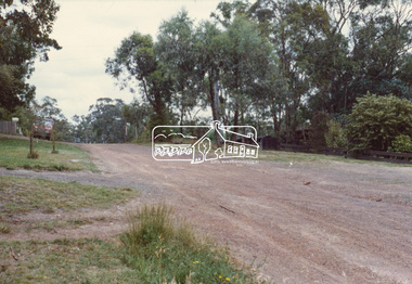
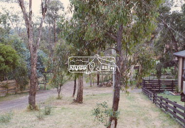
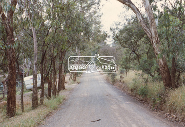
... private street scheme... of the Beard street group, a private street scheme, before construction... of the Beard street group, a private street scheme, before construction ...Roll of film taken by Eltham Shire Council officers of the Beard street group, a private street scheme, before construction commenced. They provide perspective of the changes in housing styles and road development that began sweeping in from the mid 1970s with increasing urbanisation of what was once more outlying suburbs and regions.35 mm colour positive transparency (1 of 7) Mount - Blank Card,eltham, housing estate, infrastructure, private street scheme, roads, shalbury avenue -
 Eltham District Historical Society Inc
Slide, Shalbury Avenue, Eltham, c. Jan 1983
... private street scheme... of the Beard street group, a private street scheme, before construction... of the Beard street group, a private street scheme, before construction ...Roll of film taken by Eltham Shire Council officers of the Beard street group, a private street scheme, before construction commenced. They provide perspective of the changes in housing styles and road development that began sweeping in from the mid 1970s with increasing urbanisation of what was once more outlying suburbs and regions.35 mm colour positive transparency (1 of 7) Mount - Blank Card,eltham, housing estate, infrastructure, private street scheme, roads, shalbury avenue -
 Eltham District Historical Society Inc
Slide, Andrews Street, Eltham, c. Jan 1983
... Andrews Street, Eltham...private street scheme... of the Beard street group, a private street scheme, before construction... of the Beard street group, a private street scheme, before construction ...Roll of film taken by Eltham Shire Council officers of the Beard street group, a private street scheme, before construction commenced. They provide perspective of the changes in housing styles and road development that began sweeping in from the mid 1970s with increasing urbanisation of what was once more outlying suburbs and regions.35 mm colour positive transparency (1 of 7) Mount - Blank Card,eltham, housing estate, infrastructure, private street scheme, roads, andrews street -
 Eltham District Historical Society Inc
Slide, Thomas Street, Eltham, c. Jan 1983
... Thomas Street, Eltham...private street scheme... of the Beard street group, a private street scheme, before construction... of the Beard street group, a private street scheme, before construction ...Roll of film taken by Eltham Shire Council officers of the Beard street group, a private street scheme, before construction commenced. They provide perspective of the changes in housing styles and road development that began sweeping in from the mid 1970s with increasing urbanisation of what was once more outlying suburbs and regions.35 mm colour positive transparency (1 of 7) Mount - Blank Card,eltham, housing estate, infrastructure, private street scheme, roads, thomas street -
 Eltham District Historical Society Inc
Slide, Andrews Street, Eltham, c. Jan 1983
... Andrews Street, Eltham...private street scheme... of the Beard street group, a private street scheme, before construction... of the Beard street group, a private street scheme, before construction ...Roll of film taken by Eltham Shire Council officers of the Beard street group, a private street scheme, before construction commenced. They provide perspective of the changes in housing styles and road development that began sweeping in from the mid 1970s with increasing urbanisation of what was once more outlying suburbs and regions.35 mm colour positive transparency (1 of 7) Mount - Blank Card,eltham, housing estate, infrastructure, private street scheme, roads, andrews street -
 Eltham District Historical Society Inc
Slide, Frank Street, Eltham, c. Jan 1983
... Frank Street, Eltham...private street scheme... of the Beard street group, a private street scheme, before construction... of the Beard street group, a private street scheme, before construction ...Roll of film taken by Eltham Shire Council officers of the Beard street group, a private street scheme, before construction commenced. They provide perspective of the changes in housing styles and road development that began sweeping in from the mid 1970s with increasing urbanisation of what was once more outlying suburbs and regions.35 mm colour positive transparency (1 of 7) Mount - Blank Card,eltham, housing estate, infrastructure, private street scheme, roads, frank street -
 Melbourne Tram Museum
Photograph - Bourke St from William St looking west - cable trams, c1910
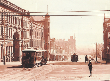
... with on the south side of Bourke Street the former St. James Building... with on the south side of Bourke Street the former St. James Building ...Photograph shows the view from William St looking west along Bourke St. Has two cable tram sets in the view, along with on the south side of Bourke Street the former St. James Building, Gollin & Company Building, then over King Street, Bourke Street West Police Station, McLean Bros. & Rigg Ironmongery & Hardware Store, (later Hudon's Store) and the Tramways Head Office Building. On the northside of Bourke Street is the Massey-Harris Building, John Connell & Co. Pty Ltd "Gresham House" and over King Street, H.V. McKay Harvester's Sunshine Head Office. Also in the distance is the Spencer Street Railway Station buildings. The Archway visible through the St. James Building led into the former Lt. James Street. Yields information about Bourke Street between 1909 and 1913Photograph - sepia toned on A4 sheetHas TMSV Sales stamp on rear.trams, bourke st, william st, cable trams, tramways, tram 402, st. james building -
 Bendigo Historical Society Inc.
Print - ETCHING OF VIEW STREET SANDHURST 1859, 1859
... ETCHING OF VIEW STREET SANDHURST 1859...view street buildings. 1859...Black and white etching of View Street buildings. Dudley... Inc. History House 11 Mackenzie Street Bendigo goldfields ...Black and white etching of View Street buildings. Dudley House. Mechanics Institute. Henry Jackson. Pikes bridge with children crossing. Horses & carts. People walking. Timber slats over creek. View street going towards Barnard street. Etching copy of original. View Street. Sandhurst. 1859. Survey & Post Office. FH 566 Not Found 8.12.2022place, bendigo, view street buildings. 1859 -
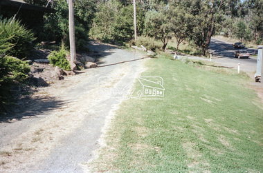
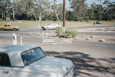
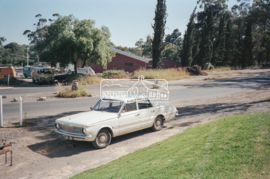
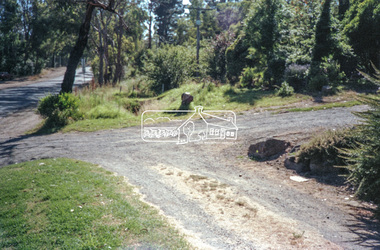
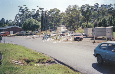
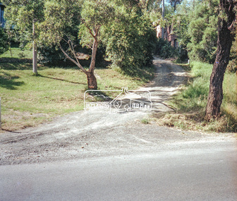
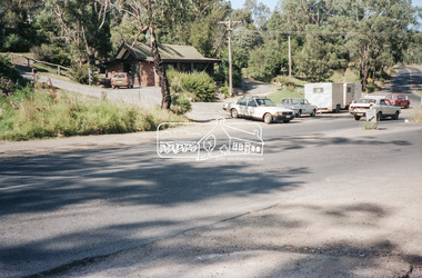 Eltham District Historical Society Inc
Negative - Photograph, Intersection of Mt Pleasant Road at Main Road, Eltham, c.Dec. 1983
... and Templestowe to be diverted down Bridge Street (and Bolton Street... and Templestowe to be diverted down Bridge Street (and Bolton Street ...Reconstruction work was planned for Main Road to install a roundabout at Mount Pleasant Road. Traffic to Lower Plenty and Templestowe to be diverted down Bridge Street (and Bolton Street) effective January 1984. The proposed roundabout did not proceed. Instead traffic islands on Mount Pleasant Road were installed in place of temporary blocked out islands and revised extended driveway to properties 622-642 Main Road with access off Mount Pleasant Road instead.Film - Kodak CM 400 5079 7 strips, 26 framesinfrastructure, roads, road construction, roundabout, road sign, main road, mount pleasant road, eltham -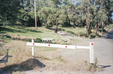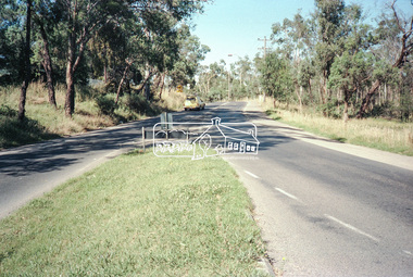
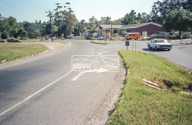 Eltham District Historical Society Inc
Negative - Photograph, Intersection of Mt Pleasant Road at Main Road, Eltham, c.Dec. 1983
... and Templestowe to be diverted down Bridge Street (and Bolton Street... and Templestowe to be diverted down Bridge Street (and Bolton Street ...Reconstruction work was planned for Main Road to install a roundabout at Mount Pleasant Road. Traffic to Lower Plenty and Templestowe to be diverted down Bridge Street (and Bolton Street) effective January 1984. The proposed roundabout did not proceed. Instead traffic islands on Mount Pleasant Road were installed in place of temporary blocked out islands and revised extended driveway to properties 622-642 Main Road with access off Mount Pleasant Road instead.Film - Kodak CM 400 5079 7 strips, 26 framesinfrastructure, roads, road construction, roundabout, road sign, main road, mount pleasant road, eltham, service station -
 Eltham District Historical Society Inc
Negative - Photograph, Intersection of Mt Pleasant Road at Main Road, Eltham, c.Dec. 1983
... and Templestowe to be diverted down Bridge Street (and Bolton Street... and Templestowe to be diverted down Bridge Street (and Bolton Street ...Reconstruction work was planned for Main Road to install a roundabout at Mount Pleasant Road. Traffic to Lower Plenty and Templestowe to be diverted down Bridge Street (and Bolton Street) effective January 1984. The proposed roundabout did not proceed. Instead traffic islands on Mount Pleasant Road were installed in place of temporary blocked out islands and revised extended driveway to properties 622-642 Main Road with access off Mount Pleasant Road instead.Film - Kodak CM 400 5079 7 strips, 26 framesinfrastructure, roads, road construction, roundabout, road sign, main road, mount pleasant road, eltham -
 Eltham District Historical Society Inc
Negative - Photograph, Intersection of Mt Pleasant Road at Main Road, Eltham, c.Dec. 1983
... and Templestowe to be diverted down Bridge Street (and Bolton Street... and Templestowe to be diverted down Bridge Street (and Bolton Street ...Reconstruction work was planned for Main Road to install a roundabout at Mount Pleasant Road. Traffic to Lower Plenty and Templestowe to be diverted down Bridge Street (and Bolton Street) effective January 1984. The proposed roundabout did not proceed. Instead traffic islands on Mount Pleasant Road were installed in place of temporary blocked out islands and revised extended driveway to properties 622-642 Main Road with access off Mount Pleasant Road instead.Film - Kodak CM 400 5079 7 strips, 26 framesinfrastructure, roads, road construction, roundabout, road sign, main road, mount pleasant road, eltham -
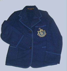 Federation University Historical Collection
Clothing - Blazer, Ballarat Teachers' College Blazer, c1948
... at Ballarat Teachers' College. She attended Urquhart Street Primary... Teachers' College. She attended Urquhart Street Primary School ...This blazer was worn by Helen Veitch while a student at Ballarat Teachers' College. She attended Urquhart Street Primary School and Ballarat High School. The first school she taught at was Wedderburn Primary School Grades 1 and 2 (46 students). She also taught at wendouree West , Urquhart Street and Pleasant Street Primary Schools. Helen Veitch married Max Bennett on 16 April 1965, and she died on 18 April 1979.Blue woollen blazer with blue braid and pocket with Ballarat Teachers' College logo. The blazer was worn by Helen Veitch.ballarat teachers' college, blazer, helen veitch -
!['Reno', St John's Parade [Kew]](/media/collectors/550653872162f11fb04854aa/items/658d16120f23e8f1e738df53/item-media/658d16680f23e8f1e738e098/item-fit-380x285.jpg) Kew Historical Society Inc
Kew Historical Society IncPhotograph - 'Reno', St John's Parade [Kew], c. 1965
... was bordered by Cotham Road, Glenferrie Road, Wellington Street... was bordered by Cotham Road, Glenferrie Road, Wellington Street ...‘Reno’, stood on the east side of St John’s Parade. Its earliest recorded owner was the architect Samuel Cocking who lived there from c.1865 until his death in 1888. The original landholding was bordered by Cotham Road, Glenferrie Road, Wellington Street, and Charles Street. The garden including rare plants supplied by Baron Von Mueller, surrounds the cottage in a tangled frenzy. Despite a ‘local significance’ classification by the National Trust, the house was demolished in 1977.This work forms part of the collection assembled by the historian Dorothy Rogers (1905-1973), donated to the Kew Historical Society by her son in 2015. The manuscripts, photographs, maps, and documents were sourced by her from both family and local collections or produced as references for her print publications. Many were directly used by Rogers in writing ‘Lovely Old Homes of Kew’ (1961) and 'A History of Kew' (1973), or the numerous articles on local history that she produced for suburban newspapers. Most of the photographs in the collection include detailed annotations in her hand. The Rogers Collection provides a comprehensive insight into the working habits of a historian from the 1960s to the 1970s. Original monochrome photograph of Reno, St John's Parade, Kew. Pictured are the garage in the distance at left, the weatherboard house with its simple verandah, and the overgrown front garden.Annotation verso: "Reno. St Johns Parade. Reno. Miss Green".dorothy rogers, reno.-- st john's parade (kew) -
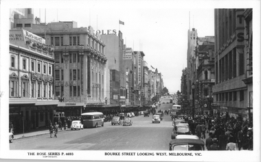 Melbourne Tram Museum
Postcard, Rose Stereograph Co, "Bourke Street Looking West, Melbourne", late 1940s
... "Bourke Street Looking West, Melbourne"...Rose Series postcard No. P 4693, titled "Bourke Street... Series postcard No. P 4693, titled "Bourke Street Looking West ...Rose Series postcard No. P 4693, titled "Bourke Street Looking West, Melbourne". Photo taken from the north side of Bourke St between Swanston St and Russell St. Has a number of double decker and single deck buses in the view. A W2 class tram is waiting on the south side of Bourke Street in Swanston Street. Photo late 1940s. The former cable tram tracks remain in the street. the Foys Department store is on the right. Yields information about the eastern end of Bourke St in the late 1940s.Postcard - printed real photograph with Rose Stereograph Co. name on the rear.tramways, trams, bourke st, buses, mmtb buses, leyland, td5c class, w2 class, swanston st -
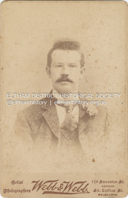 Eltham District Historical Society Inc
Photograph - Cabinet Photograph, Webb & Webb Artist Photographers, Albert Key, c.1895
... Street corner Little Collins Street, Melbourne Webb & Webb... Swanston Street corner Little Collins Street, Melbourne Webb & Webb ...Albert Key (1872-1921) was a brother of Ada Ingram (nee Key) Cabinet Photo Webb & Webb Artist Photographers 136 Swanston Street corner Little Collins Street, Melbourne Webb & Webb appeared to only operate at this location for a short time around 1895. By 1900 they were operating in Perth.On back in pencil Albert Keyalbert key, webb & webb artist photographers 136 swanston st melbourne, pam thoonen (nee ingram) collection -
 Kew Historical Society Inc
Photograph, J F C Farquhar, Bird's Eye View Looking West, 1891
... denmark street... in the foreground face the southern end of Gellibrand Street. Wellington... where we live photographic books henry kellett denmark street ...At the beginning of the 1890s, the Kew businessman and Town Councillor, Henry Kellett, commissioned J.F.C. Farquhar to photograph scenes of Kew. These scenes included panoramas as well as pastoral scenes. The resulting set of twelve photographs was assembled in an album, Kew Where We Live, from which customers could select images for purchase.The preamble to the album describes that the photographs used the ‘argentic bromide’ process, now more commonly known as the gelatine silver process. This form of dry plate photography allowed for the negatives to be kept for weeks before processing, hence its value in landscape photography. The resulting images were considered to be finely grained and everlasting. Evidence of the success of Henry Kellett’s venture can be seen today, in that some of the photographs are held in national collections.It is believed that the Kew Historical Society’s copy of the Kellett album is unique and that the photographs in the book were the first copies taken from the original plates. It is the first and most important series of images produced about Kew. The individual images have proved essential in identifying buildings and places of heritage value in the district.Before true aerial photography became possible, photographers such as J.F.C. Farquhar were compelled to shoot their images from the highest vantage point. Here, it is presumed to be the roof of Xavier College, from which the panoramic view extends west towards the rise of Studley Park. The houses in the foreground face the southern end of Gellibrand Street. Wellington Street is at an angle to the camera with the Queen Street intersection on the near right. The wooden building behind the large horse paddock on the other side of Gellibrand Street is the Kew Recreation Hall, built 1888, demolished 1960. It was reputed to have one of the finest dancing floors in or around Melbourne. The Bowling Green at the rear of the Hall belonged to the Kew Bowling Club. Further west is the Kew Railway Station on Denmark Street, opened to the public in 1887. At this period, much of Studley Park was locked up in large landholdings, dominated by large mansions such as ‘Byram’. Bird's Eye View Looking Westkew illustrated, kew where we live, photographic books, henry kellett, denmark street, kew recreation hall, kew bowling club, wellington street -
 Bendigo Historical Society Inc.
Map - GUIDE MAP OF BENDIGO & EAGLEHAWK, Late 1920's
... Showgrounds located between Park Street, Water Street, Barnard Street... Inc. History House 11 Mackenzie Street Bendigo goldfields ...Map. Guide Map of Bendigo & Eaglehawk. Light brown coloured booklet containing folded map of Bendigo and Eaglehawk. Outer cover is printed in blue and red ink and states - With compliments of J H Curnow & Son, Auctioneers, Real Estate Agents, Farm & Dairy Produce Merchants, Bendigo. Printed by J B Young, Lithographer. Map shows tramways & bus routes. Map shows Agricultural Showgrounds located between Park Street, Water Street, Barnard Street and Bridge Lane. Also shows Acclimitization Reserve located behind The Botanical Gardens at White Hills. Shows the location of Sailors Gully, Peg-Leg Gully, Jobs Gully, California Gully, Long Gully, Ironbark Gully, Golden Gully, Poverty Gully, Sheepshead Gully, Charcoal Gully, Eaglehawk Creek, Bendigo Creek and Back Creek. Contains interesting facts about Bendigo - Area 7,900 acres. Population - 26,000. First Council elected - 1855. Proclaimed a Borough - 1863. Proclaimed a City - 1871. Gold Rush broke out - 1851. For first 10 years gold yield averaged 8,600 ozs. per week . Total gold yield to 1923 - 572 tons valued at 82,000,000 pounds. Deepest mines - Victoria Quartz 4,614 ft., New Chum Railway 4,318 ft. 13 mines over 3.000 ft. deep. 53 mines over 2,000 ft. deep. Sewering of City commenced 1922, all principal buildings now sewered. Map printed by Arnall & Jackson, General Printers, Stationers & Engravers, 476 Collins Street. Map displays advertisement for J H Curnow & Son, Bendigo's leading Auctioneer and Estate Agents, Mitchell & Queen Sts. Bendigo. Map Scale 20 chs. = 1 in.cottage, miners, guide map of bendigo and eaglehawk -
 Bendigo Historical Society Inc.
Map - GUIDE MAP OF BENDIGO & EAGLEHAWK, Late 1920's
... between Park Street, Water Street, Barnard Street and Bridge Lane... Inc. History House 11 Mackenzie Street Bendigo goldfields MAP ...Map. Guide map of Bendigo & Eaglehawk. Folded map of Bendigo & Eaglehawk with blue outer cover booklet. Map is compiled by E E Parker, Eaglehawk. Map shows tramways, bus routes and cost one shilling. Map shows Agricultural Showgrounds located between Park Street, Water Street, Barnard Street and Bridge Lane. Also shows Acclimitization Reserve located behind the Botanical Gardens at White Hills. Shows the location of Sailors Gully, Peg-Leg Gully, Jobs Gully, California Gully, Long Gully, Ironbark Gully, Golden Gully, Poverty Gully, Sheepshead Gully, Charcoal Gully, Eaglehawk Creek, Bendigo Creek and Back Creek.Contains interesting facts about Bendigo:- Area - 7,900 acres, Population - 26,000, First Council elected - 1855, Proclaimed a City - 1871. Gold Rush broke out - 1851. For first 10 years gold yield averaged 8,600 ozs. Per week. Total gold yield to 1923 - 572 tons valued at 82,000,000 pounds. Deepest mines - Victoria Quartz 4,614 ft., New Chum Railway 4,318 ft., 13 mines over 3,000ft. deep, 53 mines over 2,000 ft. deep. Sewering of City commenced 1922. All principal buildings now sewered. Map printed by Arnall & Jackson, General Printers, Stationers & Engravers, 476 Collins Street. Outer map blue cover printed in red and blue ink by J B Young, Lithographer. Map displays advertisement for Bendigo Timber Co. Outer blue cover displays advertisement for Campbell Connelly & Co. Pty. Ltd, Ironmongers, Timware Manufacturers, Plumbers, Sewerage Contractors, High and Forest Sts, Bendigo 9outside back cover) and for Hartleys ( J L Shoosmith) Bendigo, displaying Indian Motor Cycles (inside back cover).map, bendigo, township, guide map of bendigo & eaglehawk -
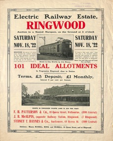 Ringwood and District Historical Society
Flyer, Land Sale Auction Brochure, Electric Railway Estate, Ringwood, Vic. - 1922
... Street, Myrtle Avenue, George Street, and Henry Street. Agents..., Williams Grove, Campbell Street, Myrtle Avenue, George Street ...Bi-folded single sheet with black and red print both sides advertising auction of allotments on Saturday, November 18, 1922, including details of subdivision features and local facilities. Subdivision includes Bedford Road, Williams Grove, Campbell Street, Myrtle Avenue, George Street, and Henry Street. Agents - F.H. Patterson & Co., 19 Queen Street, Melbourne, Tel. 4308 Central, J.B. McAlpin, Opposite Railway Station, Ringwood, Tel 7 Ringwood, SYDNEY T. Haynes & Co., Auctioneer, 60 Queen Street, Melbourne, Tel 3400 Central. -
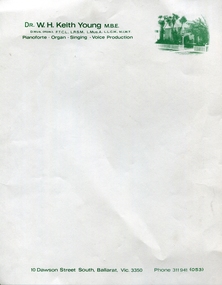 Federation University Historical Collection
Document - Document - Letterhead, Jeff Zilles, ZILLES COLLECTION: Dr W.H. Keith Young Letterhead
... 1930s. It was in McKenzie Street Ballarat. His son Jeffrey also.... It was in McKenzie Street Ballarat. His son Jeffrey also became a printer ...Zilles Printers was begun by Lewis Zilles in the early 1930s. It was in McKenzie Street Ballarat. His son Jeffrey also became a printer - letterpress, offset and screen printer. The business became Zilles Printers/Graphics and was in Armstrong Street and later Bell Street Ballarat. Letterhead produced for Dr Young - music teacher in Ballarat.Off-white paper with green printing. Image of house in top right cornerName and qualifications. Dress along bottom edgekeith young, letterhead, dawson st, music, voice production, pianoforte, organ, singing -
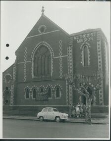 Uniting Church Archives - Synod of Victoria
Photograph, undated
... The Gipps Street Wesleyan Methodist Church of 1874... Church. The image is a street view of a group of children... Street Malvern East melbourne The Gipps Street Wesleyan Methodist ...The Gipps Street Wesleyan Methodist Church of 1874 and the adjoining school hall, were built in the Collingwood Flat area - one of the municipality's poorest areas. In 1903, the Collingwood Methodist Mission was established with its headquarters in the Gipps Street Church. Six Methodist Missions were created in inner Melbourne. Three churches were operated by the Collingwood Mission. They were: Sackville Street Collingwood, Elizabeth Street, North Richmond (demolished), and Gipps Street Collingwood (demolished). The Mission operated until approximately 1930.B & W exterior view of the Gipps St. Collingwood Methodist Church. The image is a street view of a group of children and an adult standing in front of the brick church.gipps st. methodist church, les gorrie, collingwood mission -
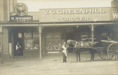 Kew Historical Society Inc
Postcard - V.G. Greenhill's Grocery Store, High Street (Kew), c.1902
... V.G. Greenhill's Grocery Store, High Street (Kew)...high street -- Kew (Vic.)... Store were located at 43 1/2 and 45 High Street (formerly... Street, Kew, circa 1902. The businesses were R. Hornby, jewellers... located at 43 1/2 and 45 High Street (formerly Bulleen Road ...R.H. Hornby & Sons, jewellers, and V. Greenhill's Grocery Store were located at 43 1/2 and 45 High Street (formerly Bulleen Road) respectively, in the block of shops between Brougham Street and Walpole Street. The grocery first appears at this location in 1893 but only in 1902 is the jeweller's shop located next door. (Sands & McDougall Directories). The Greenhill family were significant pioneers of Kew in the nineteenth century and their members participated in many civic, community and sporting organisations.Original sepia, real photo postcard of two shops in High Street, Kew, circa 1902. The businesses were R. Hornby, jewellers and opticians, and V.G. Greenhill, grocer. The proprietor of the jeweller's shop stands in his doorway while a member of staff of Greenhill's is standing on the road with a horse and cart owned by the business. The signage on the grocery shop identifies the kind of business offered - Choice fruits & confectionery / Dairy Produce a specialty. On the windows from left to right are advertisements for Fry's Chocolate, Fry's Pure Cocoa, and Cadbury's Cocoa and Cadbury's Chocolate. Above the doorway is a pane of etched glass reading GREENHILL 45.Unmarked postcard layout on reversev greenhill, grocery stores -- kew (vic.), jewellers -- kew (vic), high street -- kew (vic.), businesses -- kew (vic), hornby family, greenhill family